Traigh Ceann a' Chaolais

Coastal Marsh, Saltings in Cromartyshire

Scotland

Traigh Ceann a' Chaolais

Old Schoolhouse on Isle Martin The Isle Martin Trust is intending to renovate this so that it can be used. There is a newer schoolhouse nearer the main houses, now used as a small museum.
Old Schoolhouse on Isle Martin Credit: Chris and Meg Mellish

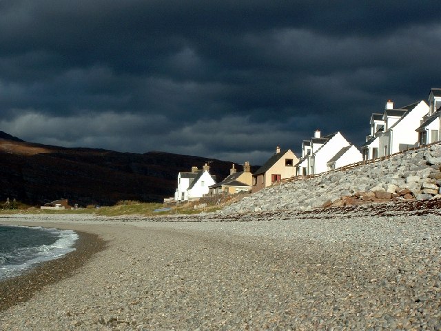
Traigh Ceann a' Chaolais, located in Cromartyshire, is a picturesque coastal marsh and saltings area known for its stunning natural beauty and diverse ecosystem. Stretching across a vast expanse of land, this coastal landscape offers visitors a unique and tranquil experience.

The marshland is characterized by its extensive network of shallow water channels, mudflats, and salt pans. These habitats provide a haven for a wide variety of plant and animal species. The area is home to an array of migratory birds, including sandpipers, curlews, and oystercatchers, which flock here during the breeding season.

The salt pans in Traigh Ceann a' Chaolais are particularly noteworthy. These shallow depressions are flooded with seawater during high tide and then left to dry during low tide, resulting in the formation of salt crystals. This process has attracted salt-loving plants and algae, creating a unique coastal ecosystem.

Aside from its ecological significance, Traigh Ceann a' Chaolais is also a popular destination for outdoor enthusiasts. The area offers several walking trails, allowing visitors to explore the marshland at their own pace. The breathtaking views of the surrounding coastline and the distant mountains make it an ideal spot for photographers and nature lovers.

In addition, the marshland plays a crucial role in flood control and water filtration, acting as a natural buffer against storm surges and filtering pollutants from the water before it reaches the sea.

Overall, Traigh Ceann a' Chaolais is a captivating and ecologically important coastal marsh and saltings area that offers both natural beauty and recreational opportunities for visitors to enjoy.

If you have any feedback on the listing, please let us know in the comments section below.

Traigh Ceann a' Chaolais Images

Images are sourced within 2km of 57.94485/-5.1805699 or Grid Reference NH1199. Thanks to Geograph Open Source API. All images are credited.

Old Schoolhouse on Isle Martin The Isle Martin Trust is intending to renovate this so that it can be used. There is a newer schoolhouse nearer the main houses, now used as a small museum.
Old Schoolhouse on Isle Martin
The Isle Martin Trust is intending to renovate this so that it can be used. There is a newer schoolhouse nearer the main houses, now used as a small museum.
Coastal path waymark approaching Blàr Mòr
View from Dùn Canna View from Dùn Canna
View from Dùn Canna
View from Dùn Canna
Camas Mòr At low tide, From the iron age fort, Dùn Canna.
Camas Mòr
At low tide, From the iron age fort, Dùn Canna.
Contrasting banks of the River Canaird The flood plain appears to be free draining whereas the moors above are not.
Contrasting banks of the River Canaird
The flood plain appears to be free draining whereas the moors above are not.
Riverside road at Blughasary
Anglers' bothy by the River Canaird
Ordnance Survey Flush Bracket 11924 This bracket can be found on the wall of a cottage in Ardmair.
The recorded details give a height of 8.1953 metres above sea level.
For more details see : <span class="nowrap"><a title="https://www.bench-marks.org.uk/bm10319" rel="nofollow ugc noopener" href="https://www.bench-marks.org.uk/bm10319">Link</a><img style="margin-left:2px;" alt="External link" title="External link - shift click to open in new window" src="https://s1.geograph.org.uk/img/external.png" width="10" height="10"/></span>
Ordnance Survey Flush Bracket 11924
This bracket can be found on the wall of a cottage in Ardmair. The recorded details give a height of 8.1953 metres above sea level. For more details see : LinkExternal link
A835, Glutton The A835 runs 66 miles from Tore to Ledmore <a href="https://www.geograph.org.uk/photo/7135759">NC2412 : A835, A837 junction, Ledmore</a>, via Ullapool.
<span class="nowrap"><a title="https://www.sabre-roads.org.uk/wiki/index.php?title=A835" rel="nofollow ugc noopener" href="https://www.sabre-roads.org.uk/wiki/index.php?title=A835">Link</a><img style="margin-left:2px;" alt="External link" title="External link - shift click to open in new window" src="https://s1.geograph.org.uk/img/external.png" width="10" height="10"/></span>
A835, Glutton
The A835 runs 66 miles from Tore to Ledmore NC2412 : A835, A837 junction, Ledmore, via Ullapool. LinkExternal link
A835 The A835 runs 66 miles from Tore to Ledmore <a href="https://www.geograph.org.uk/photo/7135759">NC2412 : A835, A837 junction, Ledmore</a>, via Ullapool.
<span class="nowrap"><a title="https://www.sabre-roads.org.uk/wiki/index.php?title=A835" rel="nofollow ugc noopener" href="https://www.sabre-roads.org.uk/wiki/index.php?title=A835">Link</a><img style="margin-left:2px;" alt="External link" title="External link - shift click to open in new window" src="https://s1.geograph.org.uk/img/external.png" width="10" height="10"/></span>
A835
The A835 runs 66 miles from Tore to Ledmore NC2412 : A835, A837 junction, Ledmore, via Ullapool. LinkExternal link
A835 approaching Loch Kanaird The North Coast 500 is a 516 mile scenic route around the north coast of Scotland, starting and ending at Inverness Castle. The route is also known as the NC500 and was launched in 2015, linking many features in the north Highlands of Scotland in one touring route.
The route has increased visitor numbers to parts of the north of Scotland, which has brought economic benefits to some areas. The increase in traffic has also led to more instances of bad and dangerous driving, as well as damage to the roads and concerns about the environmental impact. 
Apparently the route was amended in 2022 with detours etc being removed.
Wikipedia: <span class="nowrap"><a title="https://en.wikipedia.org/wiki/North_Coast_500" rel="nofollow ugc noopener" href="https://en.wikipedia.org/wiki/North_Coast_500">Link</a><img style="margin-left:2px;" alt="External link" title="External link - shift click to open in new window" src="https://s1.geograph.org.uk/img/external.png" width="10" height="10"/></span> 
Original route map: <span class="nowrap"><a title="https://en.wikipedia.org/wiki/North_Coast_500#/media/File:North_Coast_500,_Scotland.svg" rel="nofollow ugc noopener" href="https://en.wikipedia.org/wiki/North_Coast_500#/media/File:North_Coast_500,_Scotland.svg">Link</a><img style="margin-left:2px;" alt="External link" title="External link - shift click to open in new window" src="https://s1.geograph.org.uk/img/external.png" width="10" height="10"/></span> 
Latest route map: <span class="nowrap"><a title="https://www.northcoast500.com/explore-the-route/" rel="nofollow ugc noopener" href="https://www.northcoast500.com/explore-the-route/">Link</a><img style="margin-left:2px;" alt="External link" title="External link - shift click to open in new window" src="https://s1.geograph.org.uk/img/external.png" width="10" height="10"/></span>
A835 approaching Loch Kanaird
The North Coast 500 is a 516 mile scenic route around the north coast of Scotland, starting and ending at Inverness Castle. The route is also known as the NC500 and was launched in 2015, linking many features in the north Highlands of Scotland in one touring route. The route has increased visitor numbers to parts of the north of Scotland, which has brought economic benefits to some areas. The increase in traffic has also led to more instances of bad and dangerous driving, as well as damage to the roads and concerns about the environmental impact. Apparently the route was amended in 2022 with detours etc being removed. Wikipedia: LinkExternal link Original route map: LinkExternal link Latest route map: LinkExternal link
A835 towards Strathcanaird
Road towards Keanchulish
Ardmair beach on a stormy Sunday
Coigach View The view of the mighty Ben Mor Coigach as seen across the northern half of Ardmair Bay on a glorious early spring day.
Coigach View
The view of the mighty Ben Mor Coigach as seen across the northern half of Ardmair Bay on a glorious early spring day.
Ardmair Bay View across the whole extent of Ardmair Bay with Isle Martin at left and the Graham of Ben Mor Coigach centre. The holiday cottages at Ardmair can also be seen.
Ardmair Bay
View across the whole extent of Ardmair Bay with Isle Martin at left and the Graham of Ben Mor Coigach centre. The holiday cottages at Ardmair can also be seen.
View Across Loch Kanard Little jetty on Loch Kanard near Ardmair looking across to the fine mountain of Ben Mor Coigach.
View Across Loch Kanard
Little jetty on Loch Kanard near Ardmair looking across to the fine mountain of Ben Mor Coigach.
Show me another place!

Traigh Ceann a' Chaolais is located at Grid Ref: NH1199 (Lat: 57.94485, Lng: -5.1805699)

Unitary Authority: Highland

Police Authority: Highlands and Islands

What 3 Words

///townhouse.defend.fence. Near Ullapool, Highland

Related Wikis

Ardmair

Ardmair (Scottish Gaelic: Àird Mhèar) is a village in Wester Ross, in the North West Highlands of Scotland. Formerly a fishing village, Ardmair is located...

Isle Martin

Isle Martin (Scottish Gaelic: Eilean Mhàrtainn) is an uninhabited island in Loch Broom, on the west coast of Scotland. It is the closest of the Summer...

Rhue, Scotland

Rhue (An Rubha in Gaelic) is a small settlement north of Ullapool in Ross and Cromarty, and is in the Scottish council area of Highland, Scotland. ��2...

Loch Dubh Hydro-Electric Scheme

Loch Dubh Hydro-Electric Scheme is a small-scale hydro-electric power station, built by the North of Scotland Hydro-Electric Board and commissioned in...

Nearby Amenities

Located within 500m of 57.94485,-5.1805699
Source: PGS
Lat/Long: 57.9442723/-5.1884462
Source: PGS
Lat/Long: 57.9444008/-5.1878492
Source: PGS
Lat/Long: 57.9446359/-5.1870356
Source: PGS
Lat/Long: 57.9447703/-5.1867607
Source: PGS
Lat/Long: 57.944902/-5.186528
Source: PGS
Lat/Long: 57.945035/-5.186296
Source: PGS
Lat/Long: 57.9451874/-5.1859318
Source: PGS
Lat/Long: 57.9452508/-5.1856847
Source: PGS
Lat/Long: 57.9455291/-5.1855768
Source: PGS
Lat/Long: 57.945563/-5.185365
Source: PGS
Lat/Long: 57.946083/-5.184915
Source: PGS
Lat/Long: 57.9463905/-5.1844868
Source: PGS
Lat/Long: 57.9465731/-5.1841899
Source: PGS
Lat/Long: 57.9473288/-5.1832807
Source: PGS
Lat/Long: 57.9486253/-5.1837894
Source: PGS
Lat/Long: 57.9487229/-5.1839457
Source: PGS
Lat/Long: 57.9484074/-5.1784762
Source: PGS
Lat/Long: 57.9479907/-5.179458
Source: PGS
Lat/Long: 57.9475482/-5.1803217
Source: PGS
Lat/Long: 57.9473875/-5.1798802
Source: PGS
Lat/Long: 57.9470696/-5.1804384
Source: PGS
Lat/Long: 57.9470745/-5.1805806
Source: PGS
Lat/Long: 57.947097/-5.180759
Source: PGS
Lat/Long: 57.9467483/-5.1807581
Source: PGS
Lat/Long: 57.946875/-5.1814806
Source: PGS
Lat/Long: 57.9465798/-5.1814377
Source: PGS
Lat/Long: 57.9462487/-5.1812232
Source: PGS
Lat/Long: 57.9455806/-5.1806435
Source: PGS
Lat/Long: 57.9451393/-5.1792434
Source: PGS
Lat/Long: 57.9446895/-5.1785085
Source: PGS
Lat/Long: 57.9441424/-5.1780474
Source: PGS
Lat/Long: 57.9433852/-5.1777953
Source: PGS
Lat/Long: 57.9433649/-5.1777705
Source: PGS
Lat/Long: 57.9432174/-5.1786102
Source: PGS
Lat/Long: 57.9430417/-5.179159
Source: PGS
Lat/Long: 57.942933/-5.1799308
Source: PGS
Lat/Long: 57.9426777/-5.1804463
Source: PGS
Lat/Long: 57.9409318/-5.179728
Source: PGS
Lat/Long: 57.9408538/-5.1800841
Created By: almien_coastlines
Source: PGS
Lat/Long: 57.940785/-5.180259
Source: PGS
Lat/Long: 57.9405188/-5.181002
Power: pole
Lat/Long: 57.9458323/-5.1773783
Power: pole
Lat/Long: 57.945515/-5.1763846
Power: pole
Lat/Long: 57.945191/-5.175393
Power: pole
Lat/Long: 57.9448848/-5.1744181
Power: pole
Lat/Long: 57.9445686/-5.1734328
Power: pole
Lat/Long: 57.9442568/-5.1724662
The data included in this document is from www.openstreetmap.org. The data is made available under ODbL.

Have you been to Traigh Ceann a' Chaolais?

Leave your review of Traigh Ceann a' Chaolais below (or comments, questions and feedback).