Lower Howsell

Settlement in Worcestershire Malvern Hills

England

Lower Howsell

Tracks at Brook Farm The track was in regular use when photographed as crops were being harvested in the field ahead.  The Malvern Hills form the backdrop.
Tracks at Brook Farm Credit: Peter Whatley

Lower Howsell is a small village located in Worcestershire, a county in the West Midlands region of England. Situated on the outskirts of Malvern, Lower Howsell is a residential area known for its peaceful and picturesque surroundings. It is nestled amidst rolling countryside and offers stunning views of the nearby Malvern Hills, which are a designated Area of Outstanding Natural Beauty.

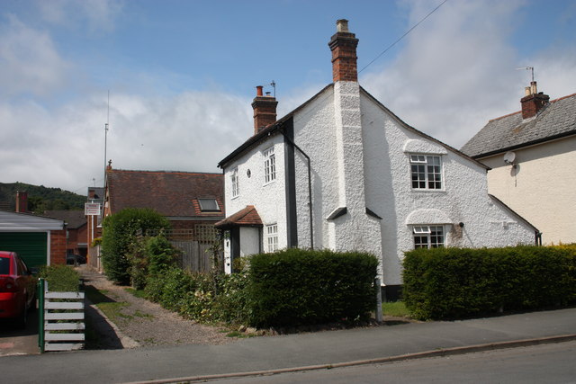
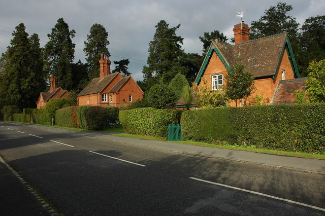
The village is primarily made up of traditional cottages and houses, reflecting its rural charm. The community is tight-knit, with a population of approximately 500 residents. Lower Howsell is known for its friendly and welcoming atmosphere, where neighbors often come together for local events and gatherings.

Despite its tranquil setting, Lower Howsell benefits from its proximity to nearby amenities. The larger town of Malvern is just a short drive away, providing residents with access to a range of shops, restaurants, and services. Additionally, the city of Worcester is easily accessible, offering further options for shopping, entertainment, and employment.

Nature enthusiasts are drawn to Lower Howsell due to its idyllic location. The Malvern Hills, with their extensive network of walking trails, are a popular destination for outdoor activities such as hiking, cycling, and horse riding. The village is also close to several parks and green spaces, providing ample opportunities for recreation and relaxation.

Overall, Lower Howsell offers a peaceful and rural lifestyle within reach of essential amenities and stunning natural surroundings, making it an attractive place to live for those seeking a balance between tranquility and convenience.

If you have any feedback on the listing, please let us know in the comments section below.

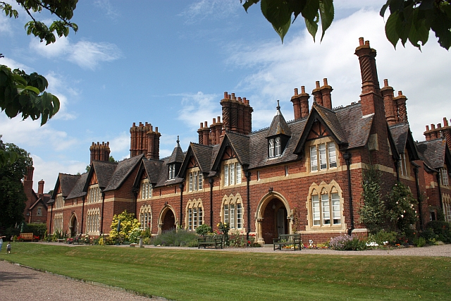
Lower Howsell Images

Images are sourced within 2km of 52.136644/-2.294378 or Grid Reference SO7948. Thanks to Geograph Open Source API. All images are credited.

Tracks at Brook Farm The track was in regular use when photographed as crops were being harvested in the field ahead.  The Malvern Hills form the backdrop.
Tracks at Brook Farm
The track was in regular use when photographed as crops were being harvested in the field ahead. The Malvern Hills form the backdrop.
Field and footpath A field beside the Malvern to Worcester railway line, a footpath to Bransfoed crosses this field.
Field and footpath
A field beside the Malvern to Worcester railway line, a footpath to Bransfoed crosses this field.
Stocks Lane by North Wood Cottage The red shipping container has appeared here since earlier visits to this spot.
Stocks Lane by North Wood Cottage
The red shipping container has appeared here since earlier visits to this spot.
North Wood Cottage, Stocks Lane A small enclosure in North Wood which can be seen in the background.
North Wood Cottage, Stocks Lane
A small enclosure in North Wood which can be seen in the background.
North Wood Cottage, near Leigh Sinton Tucked away from Stocks Lane and surrounded on three sides by the wood. Amount of daylight received must be minimal.
North Wood Cottage, near Leigh Sinton
Tucked away from Stocks Lane and surrounded on three sides by the wood. Amount of daylight received must be minimal.
Stocks Lane at North Wood Cottage Brook Wood in the distance.
Stocks Lane at North Wood Cottage
Brook Wood in the distance.
Stubble field by Stocks Lane Looking north-west in the general direction of Leigh Sinton.
Stubble field by Stocks Lane
Looking north-west in the general direction of Leigh Sinton.
Stocks Lane Looking north-west towards Leigh Sinton.
North Wood is opposite.
Stocks Lane
Looking north-west towards Leigh Sinton. North Wood is opposite.
Hampden Road, Malvern Link Residential cul-de-sac just off the main road and shops.
Part of the mid-late Victorian boom of Malvern.
Hampden Road, Malvern Link
Residential cul-de-sac just off the main road and shops. Part of the mid-late Victorian boom of Malvern.
Field Cottage, Hampden Road, Malvern Link Much older than the surrounding streets, this cottage is orthogonal to Hampden Road and sits on its own lane dating from when this was all fields.
Field Cottage, Hampden Road, Malvern Link
Much older than the surrounding streets, this cottage is orthogonal to Hampden Road and sits on its own lane dating from when this was all fields.
Hampden Road, Malvern Link Looking into the dead end of this residential cul-de-sac.
St Matthias Church in the distance.
Hampden Road, Malvern Link
Looking into the dead end of this residential cul-de-sac. St Matthias Church in the distance.
St Matthias Church Viewed from the end of the cul-de-sac of Hampden Road giving an excellent view of the tower.
The original church to seat 300 people cost £1900 and was consecrated on 13th January 1846.
Malvern was rapidly expanding at this time and, despite the church being extended in 1858, it was decided to almost rebuild it in the 1880s.
The new church, without a tower, cost £3200 and was completed in 1881.
The tower was added in 1889.
St Matthias Church
Viewed from the end of the cul-de-sac of Hampden Road giving an excellent view of the tower. The original church to seat 300 people cost £1900 and was consecrated on 13th January 1846. Malvern was rapidly expanding at this time and, despite the church being extended in 1858, it was decided to almost rebuild it in the 1880s. The new church, without a tower, cost £3200 and was completed in 1881. The tower was added in 1889.
St Matthias in stained glass, Malvern Link The window is by Kempe and is just inside the north door of St Matthias church. 
St Matthias was chosen to replace Judas as one of the twelve disciples. 
He carries the instrument of his own martyrdom, an axe. 
It is said he was beheaded after being stoned in Jerusalem.
<a href="https://www.geograph.org.uk/photo/2480210">SO7847 : St Matthias Church</a>
St Matthias in stained glass, Malvern Link
The window is by Kempe and is just inside the north door of St Matthias church. St Matthias was chosen to replace Judas as one of the twelve disciples. He carries the instrument of his own martyrdom, an axe. It is said he was beheaded after being stoned in Jerusalem. SO7847 : St Matthias Church
"Tree of Life" east window, St. Matthias, Malvern Link The magnificent window is by Kempe with a quotation from Revelation 22:2 :-
"The tree of life, which bare twelve manner of fruits, and yielded her fruit every month:
and the leaves of the tree were for the healing of the nations."
<a href="https://www.geograph.org.uk/photo/2480210">SO7847 : St Matthias Church</a>
"Tree of Life" east window, St. Matthias, Malvern Link
The magnificent window is by Kempe with a quotation from Revelation 22:2 :- "The tree of life, which bare twelve manner of fruits, and yielded her fruit every month: and the leaves of the tree were for the healing of the nations." SO7847 : St Matthias Church
West window, St. Matthias church, Malvern Link The left window depicts "Saint Peter's vision at Joppa" and the right hand one: the "Baptism of Cornelius".
<a href="https://www.geograph.org.uk/photo/2480210">SO7847 : St Matthias Church</a>
West window, St. Matthias church, Malvern Link
The left window depicts "Saint Peter's vision at Joppa" and the right hand one: the "Baptism of Cornelius". SO7847 : St Matthias Church
Morgan visitors' centre In a mixture of old wartime buildings and newer.
This was the RRE Sports and Social Club.
The long, low arched building, behind the white doors, was our skittle alley.
<a href="https://www.geograph.org.uk/photo/2494092">SO7847 : Morgan Aero Supersport</a>
Morgan visitors' centre
In a mixture of old wartime buildings and newer. This was the RRE Sports and Social Club. The long, low arched building, behind the white doors, was our skittle alley. SO7847 : Morgan Aero Supersport
Morgan Aero Supersport In the Morgan visitors'centre salesroom near to the Malvern Motor Company's Pickersleigh Road factory.  
4.8 litre, 170 mph, 6 speed gearbox.
<a href="https://www.geograph.org.uk/photo/2494061">SO7847 : Morgan visitors' centre</a>
Morgan Aero Supersport
In the Morgan visitors'centre salesroom near to the Malvern Motor Company's Pickersleigh Road factory. 4.8 litre, 170 mph, 6 speed gearbox. SO7847 : Morgan visitors' centre
The Bakery Inn, Malvern Link
Show me another place!

Lower Howsell is located at Grid Ref: SO7948 (Lat: 52.136644, Lng: -2.294378)

Administrative County: Worcestershire

District: Malvern Hills

Police Authority: West Mercia

What 3 Words

///small.outings.roughness. Near Great Malvern, Worcestershire

Related Wikis

Newland, Worcestershire

Newland is a village and civil parish on the north-eastern edge of Malvern Link, Worcestershire, England, on the A449 road. The village lies on the edge...

Newland Halt railway station

Newland Halt railway station was a station in Newland, Worcestershire, England. The station was opened on 18 March 1929 and closed on 5 April 1965. �...

Madresfield

Madresfield is a village and civil parish in the administrative district of Malvern Hills in the county of Worcestershire, England. It is located about...

West Worcestershire (UK Parliament constituency)

West Worcestershire is a constituency in Worcestershire represented in the House of Commons of the UK Parliament since 2010 by Harriett Baldwin, a Conservative...

Madresfield Court

Madresfield Court is a country house in Malvern, Worcestershire, England. The home of the Lygon family for nearly six centuries, it has never been sold...

Church of St Matthias, Malvern Link

The Church of St Matthias is an Anglican place of worship in Malvern Link, England. Prior to the establishment of this church, the residents of Malvern...

Malvern Link

Malvern Link is an area of Malvern, Worcestershire, England to the north and east of Great Malvern. The centres of Malvern Link and Great Malvern are separated...

Malvern Link railway station

Malvern Link railway station serves Malvern Link in Worcestershire, England. It is one of two stations serving the town of Malvern, the other being Great...

Nearby Amenities

Located within 500m of 52.136644,-2.294378
Bus Stop
Stocks Lane
Bus: yes
Naptan AtcoCode: 2000G502036
Naptan Bearing: S
Naptan CommonName: Stocks Lane
Naptan Crossing: Stocks Lane
Naptan NaptanCode: wocgdpaw
Naptan PlusbusZoneRef: GTMLVRN
Naptan Street: Worcester Road
Naptan Verified: no
Public Transport: platform
Source: naptan_import
Lat/Long: 52.1393093/-2.298645
Bus Stop
Newland Church
Bus: yes
Naptan AtcoCode: 2000G502037
Naptan Bearing: NE
Naptan CommonName: Newland Church
Naptan Indicator: opp
Naptan Landmark: Church
Naptan NaptanCode: wocdjtmt
Naptan PlusbusZoneRef: GTMLVRN
Naptan Street: Worcester Road
Naptan Verified: no
Public Transport: platform
Source: naptan_import
Lat/Long: 52.1347147/-2.3007994
Bus Stop
Newland Church
Bus: yes
Naptan AtcoCode: 2000G502038
Naptan Bearing: SW
Naptan CommonName: Newland Church
Naptan Indicator: adj
Naptan Landmark: Church
Naptan NaptanCode: wocdjtmw
Naptan PlusbusZoneRef: GTMLVRN
Naptan Street: Worcester Road
Naptan Verified: yes
Public Transport: platform
Source: naptan_import;manual
Lat/Long: 52.1349225/-2.3002116
Bus Stop
Stocks Lane
Bus: yes
Naptan AtcoCode: 2000G502046
Naptan Bearing: N
Naptan CommonName: Stocks Lane
Naptan Indicator: adj
Naptan Landmark: Swan Inn
Naptan NaptanCode: wocdjtpt
Naptan PlusbusZoneRef: GTMLVRN
Naptan Street: Stocks Lane
Naptan Verified: no
Public Transport: platform
Source: naptan_import
Lat/Long: 52.1390156/-2.2994694
Post Box
Collection Plate: CP7
Collection Times: Mo-Fr 17:00; Sa 07:00
Historic Operator: Royal Mail
Manufacturer: Machan Scotland
Note: RM replaced this box on about 2010-12-15; it had been stolen. It is now on a pier rather than being strapped to a post.
Post Box Mounting: wooden_post
Post Box Type: lamp
Ref: WR13 131
Royal Cypher: EIIR
Royal Cypher Wikidata: Q33102113
Lat/Long: 52.1345693/-2.3000792
Fixme: continue
Lat/Long: 52.1346013/-2.2992727
Pub
The Swan Inn
Lat/Long: 52.138673/-2.3000563
Newland
Place: village
Wikidata: Q955958
Wikipedia: en:Newland, Worcestershire
Lat/Long: 52.1371794/-2.2994291
Location Transition: yes
Power: pole
Lat/Long: 52.1349204/-2.3010577
Stocks Farm Newland
Power: pole
Transformer: distribution
Voltage Primary: 11000
Lat/Long: 52.1362893/-2.3005816
Power: pole
Lat/Long: 52.1389007/-2.3003778
Swan Inn
Power: pole
Transformer: distribution
Voltage Primary: 11000
Lat/Long: 52.1384591/-2.3003845
Power: pole
Lat/Long: 52.1377282/-2.3006608
Power: pole
Lat/Long: 52.1370227/-2.3009491
Power: pole
Lat/Long: 52.1360514/-2.3013139
The Grange
Power: pole
Transformer: distribution
Voltage Primary: 11000
Lat/Long: 52.134084/-2.295983
Power: pole
Lat/Long: 52.1370334/-2.2909069
Ashbed Cottage
Power: pole
Transformer: distribution
Voltage Primary: 11000
Lat/Long: 52.1397143/-2.2891273
Power: pole
Lat/Long: 52.1390797/-2.2893231
Power: pole
Lat/Long: 52.1384492/-2.2895283
Power: pole
Lat/Long: 52.1378171/-2.2897348
Power: pole
Lat/Long: 52.1374343/-2.2902873
Power: pole
Lat/Long: 52.1366293/-2.2915091
Power: pole
Lat/Long: 52.1360547/-2.2924358
Power: pole
Lat/Long: 52.1355172/-2.2932968
Power: pole
Lat/Long: 52.1349821/-2.2941095
Power: pole
Lat/Long: 52.1344718/-2.2949342
Power: pole
Lat/Long: 52.1342092/-2.295114
Power: pole
Lat/Long: 52.1334843/-2.2946466
Power: pole
Lat/Long: 52.1338149/-2.2953875
Benlake
Location Transition: yes
Power: pole
Transformer: distribution
Voltage Primary: 11000
Lat/Long: 52.1331616/-2.2939197
The data included in this document is from www.openstreetmap.org. The data is made available under ODbL.

Have you been to Lower Howsell?

Leave your review of Lower Howsell below (or comments, questions and feedback).