An Currachd
Coastal Marsh, Saltings in Argyllshire
Scotland
An Currachd

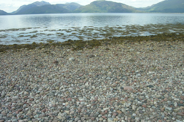
An Currachd, located in Argyllshire, is a coastal marsh area characterized by its extensive saltings. The site is situated along the western coast of Scotland, near the village of Kilcreggan. An Currachd covers a total area of approximately 100 hectares and is known for its rich biodiversity and unique coastal ecosystem.
The marshland of An Currachd is composed of a combination of fresh and brackish water, resulting in a diverse array of plant and animal species. The saltings, which are coastal areas that are regularly flooded by the tides, provide a vital habitat for numerous species of salt-tolerant plants. These include sea aster, sea lavender, and various types of grasses.
The marshland is also home to a variety of bird species, making it an important site for birdwatchers and ornithologists. Common sightings include wading birds such as curlews, oystercatchers, and redshanks. Additionally, the area serves as a breeding ground for several species of ducks, including teal and mallards.
An Currachd is not only a haven for wildlife but also a site of historical and cultural significance. The marshland has been utilized by local communities for centuries, particularly for grazing livestock and harvesting salt from the saltings. These traditional practices have contributed to shaping the landscape and maintaining the ecological balance of the area.
Overall, An Currachd in Argyllshire stands as a remarkable coastal marshland, with its diverse plant and animal life, as well as its historical and cultural significance. It offers visitors a unique opportunity to explore and appreciate the beauty and importance of this coastal ecosystem.
If you have any feedback on the listing, please let us know in the comments section below.
An Currachd Images
Images are sourced within 2km of 56.675039/-5.2445616 or Grid Reference NN0158. Thanks to Geograph Open Source API. All images are credited.


An Currachd is located at Grid Ref: NN0158 (Lat: 56.675039, Lng: -5.2445616)
Unitary Authority: Highland
Police Authority: Highlands and Islands
What 3 Words
///junction.depths.fines. Near Glencoe, Highland
Nearby Locations
Related Wikis

Kentallen railway station
Kentallen was a railway station at the head of Kentallen Bay, which is on the southern shore of Loch Linnhe in the Highland council area of Scotland. It...

Loch Linnhe
Loch Linnhe ( lokh LIN-ee) is a sea loch on the west coast of Scotland. The part upstream of Corran is known in Gaelic as An Linne Dhubh (the black pool...

Onich
Onich (; Gaelic: Omhanaich, 'abounding in froth, frothy place'), also spelled Ounich, is a village in the historic county of Inverness-shire on the east...

Glenachulish
Glenachulish (Scottish Gaelic: Gleann a' Chaolais: valley of the narrows; pronounced Glen – ah – hoolish) is a hamlet and glen which lie close to the village...
Ballachulish House
Ballachulish House is a restaurant located in Ballachulish, Highland, Scotland. As of 2008, the restaurant holds one star in the Michelin Guide. ��2�...

Duror
Duror (Scottish Gaelic: An Dùrar, meaning hard water), occasionally Duror of Appin, is a small, remote coastal village that sits at the base of Glen Duror...

Achindarroch
Achadh nan Darach (English: Achindarroch or Achnandarach) is a hamlet in Highland, Scotland. It lies near the banks of Loch Linnhe on the A828 road, just...

Ballachulish Ferry railway station
Ballachulish Ferry was a railway station on the south shore at the narrows of Loch Leven at South Ballachulish in Highland region, Scotland. It was on...
Nearby Amenities
Located within 500m of 56.675039,-5.2445616Have you been to An Currachd?
Leave your review of An Currachd below (or comments, questions and feedback).