Beavan's Hill

Settlement in Herefordshire

England

Beavan's Hill

Message on the road, Linton Hill, Herefordshire What more need I say?
Message on the road, Linton Hill, Herefordshire Credit: A J Paxton

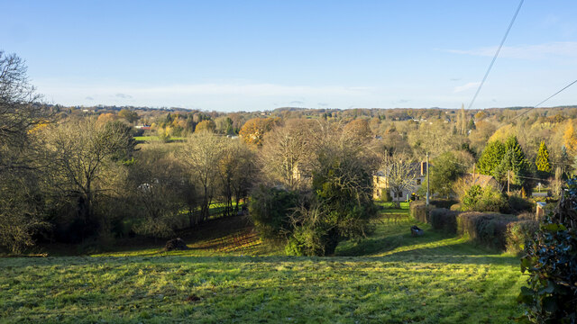
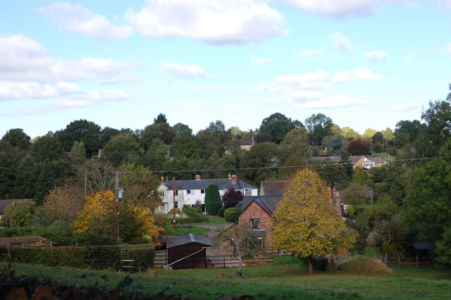
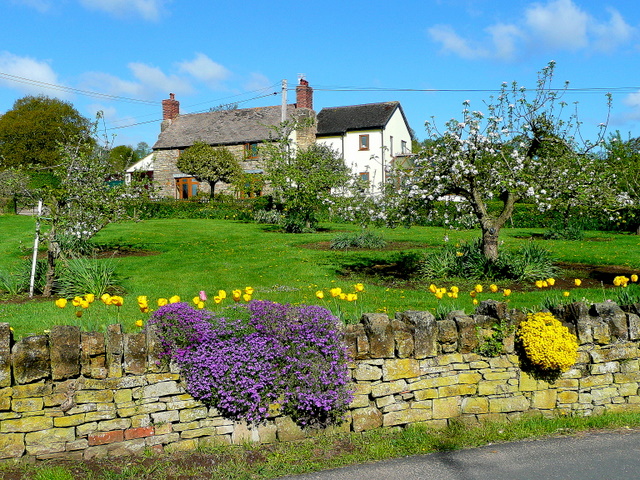
Beavan's Hill is a small village located in the county of Herefordshire, England. Situated in the western part of the county, it is nestled within the beautiful countryside and offers stunning views of the surrounding landscape. The village is part of the civil parish of Ewyas Harold.

The village is known for its peaceful and idyllic atmosphere, making it an ideal destination for those seeking a tranquil retreat. Its rural setting provides ample opportunities for outdoor activities such as hiking, cycling, and horseback riding. The nearby Golden Valley and the Black Mountains offer stunning natural landscapes for exploration.

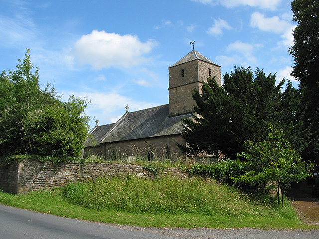
Beavan's Hill is a tight-knit community with a small population, primarily consisting of local residents who have lived in the area for generations. The village has a close community spirit and a strong sense of pride in its heritage. The historic St. Michael and All Angels Church, dating back to the 12th century, stands as a testament to the village's rich history.

Although Beavan's Hill is a small village, it is not far from larger towns and cities. The market town of Abergavenny is within easy reach, offering a range of amenities including shops, restaurants, and leisure facilities. The city of Hereford is also a short distance away, providing further options for entertainment and cultural experiences.

Overall, Beavan's Hill offers a peaceful and picturesque setting, making it an attractive destination for those seeking a rural escape amidst the natural beauty of Herefordshire.

If you have any feedback on the listing, please let us know in the comments section below.

Beavan's Hill Images

Images are sourced within 2km of 51.920388/-2.4676731 or Grid Reference SO6724. Thanks to Geograph Open Source API. All images are credited.

Message on the road, Linton Hill, Herefordshire What more need I say?
Message on the road, Linton Hill, Herefordshire
What more need I say?
Footpath from Linton Hill The Malvern Hills can be seen on the horizon from the western, Herefordshire, side.
Footpath from Linton Hill
The Malvern Hills can be seen on the horizon from the western, Herefordshire, side.
Track to Briery Hill A fine sunny scene with late autumnal lighting.
Track to Briery Hill
A fine sunny scene with late autumnal lighting.
Herefordshire meets Gloucestershire Woodland and small slivers of pasture land.
Herefordshire meets Gloucestershire
Woodland and small slivers of pasture land.
Snowdrops, sandstone wall Near the road junction by Gorsley Cross and the Roadmaker PH.
Snowdrops, sandstone wall
Near the road junction by Gorsley Cross and the Roadmaker PH.
Gorsley Goffs Summer Fete, 2022 Plenty of activity here, but those clouds approaching are going to stop play temporarily within ten minutes of this photo being taken.
Gorsley Goffs Summer Fete, 2022
Plenty of activity here, but those clouds approaching are going to stop play temporarily within ten minutes of this photo being taken.
May Hill in late summer This spot on the Linton ridge affords a great view of the distinctive dome of May Hill above the harvested fields of this corner of Herefordshire.
May Hill in late summer
This spot on the Linton ridge affords a great view of the distinctive dome of May Hill above the harvested fields of this corner of Herefordshire.
Christ Church, Gorsley Church of England church in the Diocese of Gloucester viewed from the south side of the B4221.
Christ Church, Gorsley
Church of England church in the Diocese of Gloucester viewed from the south side of the B4221.
Churchyard entrance gates, Gorsley, Gloucestershire Alongside the B4221 near the entrance porch to Christ
Church in the Church of England Diocese of Gloucester.
Churchyard entrance gates, Gorsley, Gloucestershire
Alongside the B4221 near the entrance porch to Christ Church in the Church of England Diocese of Gloucester.
GORSLEY - Please drive carefully At this sign alongside the B4221 near the corner of 
Stoney Road, the 50mph speed limit drops to 40mph.
GORSLEY - Please drive carefully
At this sign alongside the B4221 near the corner of Stoney Road, the 50mph speed limit drops to 40mph.
East side of the Roadmaker Inn, Gorsley Viewed from the B4221 in April 2023 when the Roadmaker Inn is owned 
and run by former Ghurka soldiers who served in the 1st Royal Ghurka Rifles.
East side of the Roadmaker Inn, Gorsley
Viewed from the B4221 in April 2023 when the Roadmaker Inn is owned and run by former Ghurka soldiers who served in the 1st Royal Ghurka Rifles.
Linton Village Hall, Herefordshire There are two Herefordshire villages named Linton.
This one is near Ross-on-Wye. The other one is near Bromyard.
Linton Village Hall, Herefordshire
There are two Herefordshire villages named Linton. This one is near Ross-on-Wye. The other one is near Bromyard.
West side of Linton Village Hall, Herefordshire There are two Herefordshire villages named Linton.
This one is near Ross-on-Wye. The other one is near Bromyard.
West side of Linton Village Hall, Herefordshire
There are two Herefordshire villages named Linton. This one is near Ross-on-Wye. The other one is near Bromyard.
Churchyard tree and shed, Linton, Herefordshire In St Mary the Virgin churchyard in the Church of England Diocese of Hereford.
There are two Herefordshire villages named Linton.
This one is near Ross-on-Wye. The other one is near Bromyard.
Churchyard tree and shed, Linton, Herefordshire
In St Mary the Virgin churchyard in the Church of England Diocese of Hereford. There are two Herefordshire villages named Linton. This one is near Ross-on-Wye. The other one is near Bromyard.
Open gate, Linton, Herefordshire At an exit from St Mary the Virgin churchyard 
in the Church of England Diocese of Hereford.
There are two Herefordshire villages named Linton.
This one is near Ross-on-Wye. The other one is near Bromyard.
Open gate, Linton, Herefordshire
At an exit from St Mary the Virgin churchyard in the Church of England Diocese of Hereford. There are two Herefordshire villages named Linton. This one is near Ross-on-Wye. The other one is near Bromyard.
Narrow track, Linton, Herefordshire Between weeds and the stone wall at the perimeter of the village hall site.
There are two Herefordshire villages named Linton.
This one is near Ross-on-Wye. The other one is near Bromyard.
Narrow track, Linton, Herefordshire
Between weeds and the stone wall at the perimeter of the village hall site. There are two Herefordshire villages named Linton. This one is near Ross-on-Wye. The other one is near Bromyard.
Village hall car park exit, Linton, Herefordshire Part of the village hall <a title="https://www.geograph.org.uk/photo/7495712" href="https://www.geograph.org.uk/photo/7495712">Link</a> is on the right.
There are two Herefordshire villages named Linton.
This one is near Ross-on-Wye. The other one is near Bromyard.
Village hall car park exit, Linton, Herefordshire
Part of the village hall Link is on the right. There are two Herefordshire villages named Linton. This one is near Ross-on-Wye. The other one is near Bromyard.
Track towards the churchyard, Linton, Herefordshire Ahead for St Mary the Virgin churchyard in the Church of England Diocese of Hereford.
There are two Herefordshire villages named Linton.
This one is near Ross-on-Wye. The other one is near Bromyard.
Track towards the churchyard, Linton, Herefordshire
Ahead for St Mary the Virgin churchyard in the Church of England Diocese of Hereford. There are two Herefordshire villages named Linton. This one is near Ross-on-Wye. The other one is near Bromyard.
Show me another place!

Beavan's Hill is located at Grid Ref: SO6724 (Lat: 51.920388, Lng: -2.4676731)

Unitary Authority: County of Herefordshire

Police Authority: West Mercia

What 3 Words

///worldwide.shame.glad. Near Linton, Herefordshire

Related Wikis

Beavan's Hill

Beavan's Hill is a village in south east Herefordshire, England. The village is situated on the edge of Withymoor Wood, an area of ancient woodland, and...

Gorsley and Kilcot

Gorsley and Kilcot is a civil parish forming part of the district of the Forest of Dean in the English county of Gloucestershire. The single parish of...

Gorsley

Gorsley is a small village in the Forest of Dean district of Gloucestershire, forming part of the civil parish of Gorsley and Kilcot in the South West...

Gorsley Common

Gorsley Common is a village in Herefordshire, west of Gorsley and Kilcot and east of Linton. == References == == External links == Media related to Gorsley...

Aston Ingham

Aston Ingham is a village in south-eastern Herefordshire, England, near Newent and about 7 miles (11 km) east of Ross-on-Wye. The population of the village...

Linton (near Ross-on-Wye)

Linton is a village and civil parish in south-east Herefordshire, England, approximately 3 miles (5 km) east of Ross-on-Wye. The village church of St Mary...

Burton Court, Linton

Burton Court is a grade II listed, large country house near Linton, Penyard, Herefordshire, England.The house is of brick-faced stone, with five bays....

Boulsdon

Boulsdon is a village in Gloucestershire, England. It is the location of the International Centre for Birds of Prey.A low mound in the village may have...

Nearby Amenities

Located within 500m of 51.920388,-2.4676731
Generator Output Electricity: yes
Generator Source: solar
Location: roof
Power: generator
Lat/Long: 51.9238591/-2.4639899
Generator Output Electricity: yes
Generator Source: solar
Location: roof
Power: generator
Lat/Long: 51.9215598/-2.4618092
Generator Output Electricity: yes
Generator Source: solar
Location: ground
Power: generator
Lat/Long: 51.9211826/-2.46631
Generator Output Electricity: yes
Generator Source: solar
Location: roof
Power: generator
Lat/Long: 51.9183968/-2.4695206
Power: pole
Lat/Long: 51.9244225/-2.4700644
Sergents Farm
Power: pole
Transformer: distribution
Voltage Primary: 11000
Lat/Long: 51.9236949/-2.470057
Power: pole
Lat/Long: 51.9239989/-2.4700543
Beavans Hill
Power: pole
Transformer: distribution
Voltage Primary: 11000
Lat/Long: 51.9183889/-2.4680189
Power: pole
Lat/Long: 51.9186166/-2.4675109
Power: pole
Lat/Long: 51.9188246/-2.4670378
Babylon Farm
Power: pole
Transformer: distribution
Voltage Primary: 11000
Lat/Long: 51.9206351/-2.4690311
Power: pole
Lat/Long: 51.9203298/-2.4684007
Power: pole
Lat/Long: 51.9201276/-2.4679877
Power: pole
Lat/Long: 51.9198782/-2.4674875
Power: pole
Lat/Long: 51.9194688/-2.4670435
Power: pole
Lat/Long: 51.919032/-2.4665742
Power: pole
Lat/Long: 51.9193253/-2.465907
Power: pole
Lat/Long: 51.9195879/-2.4653263
Power: pole
Lat/Long: 51.9199903/-2.464881
Power: pole
Lat/Long: 51.920427/-2.4643976
Power: pole
Lat/Long: 51.9207149/-2.4636673
Babylon Farm East
Power: pole
Transformer: distribution
Voltage Primary: 11000
Lat/Long: 51.9210118/-2.4629123
Power: pole
Lat/Long: 51.9211404/-2.4620808
Power: pole
Lat/Long: 51.9212707/-2.4611997
Power: pole
Lat/Long: 51.921879/-2.461136
Power: pole
Lat/Long: 51.9222508/-2.4616563
Power: pole
Lat/Long: 51.9228716/-2.4618468
Pine House
Power: pole
Transformer: distribution
Voltage Primary: 11000
Lat/Long: 51.9228463/-2.4635889
Power: pole
Lat/Long: 51.9227367/-2.4623369
Power: pole
Lat/Long: 51.9232111/-2.4627621
Power: pole
Lat/Long: 51.9237222/-2.463212
Stoneleigh Farm
Location Transition: yes
Power: pole
Transformer: distribution
Voltage Primary: 11000
Lat/Long: 51.9239753/-2.4634286
Baldwins Meadows
Power: pole
Transformer: distribution
Voltage Primary: 11000
Lat/Long: 51.9232686/-2.4719285
Power: pole
Lat/Long: 51.9233422/-2.4724978
The data included in this document is from www.openstreetmap.org. The data is made available under ODbL.

Have you been to Beavan's Hill?

Leave your review of Beavan's Hill below (or comments, questions and feedback).