Corran Glas

Coastal Marsh, Saltings in Inverness-shire

Scotland

Corran Glas

A87 at Sconser
A87 at Sconser Credit: Steven Brown

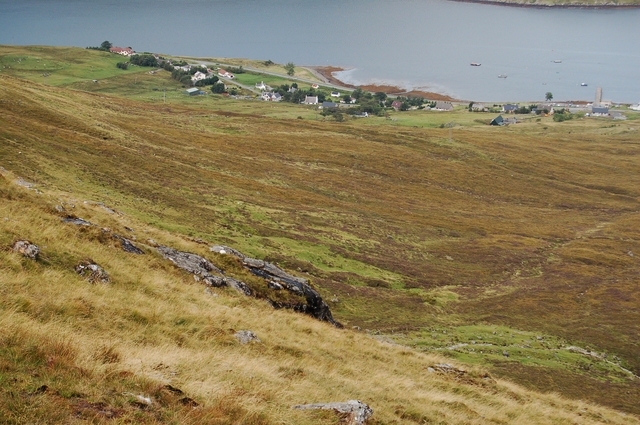
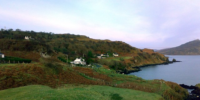
Corran Glas is a coastal marsh located in Inverness-shire, Scotland. Situated along the shores of the Moray Firth, it is an area characterized by its unique salt marshes, commonly known as saltings.

Covering an expansive stretch of land, Corran Glas features a diverse range of habitats and wildlife. The marshes are a haven for numerous bird species, including waders, ducks, and geese, which migrate here during the winter months. These birds are attracted to the rich feeding grounds provided by the salt marshes and mudflats, which are teeming with small invertebrates and marine life.

The area is also home to a variety of plant species that have adapted to the brackish conditions of the marshes. Salt-tolerant grasses and sedges dominate the landscape, providing crucial habitat and protection for many organisms. The marshes act as a natural filter, helping to improve water quality by capturing sediments and nutrients.

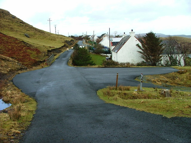
Corran Glas is not only important for its ecological significance but also for its historical and cultural value. The marshes have been utilized by humans for centuries, with evidence of ancient settlements and archaeological finds in the area. The unique landscape and biodiversity of Corran Glas make it an attractive destination for nature enthusiasts and birdwatchers, who can enjoy stunning views of the Moray Firth and its surrounding coastal scenery.

Overall, Corran Glas in Inverness-shire is a captivating coastal marsh known for its salt marshes, diverse wildlife, and rich cultural history.

If you have any feedback on the listing, please let us know in the comments section below.

Corran Glas Images

Images are sourced within 2km of 57.316581/-6.1277064 or Grid Reference NG5132. Thanks to Geograph Open Source API. All images are credited.

A87 at Sconser
A87 at Sconser
A87 near Sconser
A87 near Sconser
A87 at Sconser
A87 at Sconser
New building at Torr Dubh
Entering Sconser, A87 The A87 runs 99 miles from Invergarry to Uig on the Isle of Skye <a href="https://www.geograph.org.uk/photo/7374675">NG3863 : End of the A87, Uig</a>.
<span class="nowrap"><a title="https://www.sabre-roads.org.uk/wiki/index.php?title=A87" rel="nofollow ugc noopener" href="https://www.sabre-roads.org.uk/wiki/index.php?title=A87">Link</a><img style="margin-left:2px;" alt="External link" title="External link - shift click to open in new window" src="https://s1.geograph.org.uk/img/external.png" width="10" height="10"/></span>
Entering Sconser, A87
The A87 runs 99 miles from Invergarry to Uig on the Isle of Skye NG3863 : End of the A87, Uig. LinkExternal link
A87, Sconser The A87 runs 99 miles from Invergarry to Uig on the Isle of Skye <a href="https://www.geograph.org.uk/photo/7374675">NG3863 : End of the A87, Uig</a>.
<span class="nowrap"><a title="https://www.sabre-roads.org.uk/wiki/index.php?title=A87" rel="nofollow ugc noopener" href="https://www.sabre-roads.org.uk/wiki/index.php?title=A87">Link</a><img style="margin-left:2px;" alt="External link" title="External link - shift click to open in new window" src="https://s1.geograph.org.uk/img/external.png" width="10" height="10"/></span>
A87, Sconser
The A87 runs 99 miles from Invergarry to Uig on the Isle of Skye NG3863 : End of the A87, Uig. LinkExternal link
A87 The A87 runs 99 miles from Invergarry to Uig on the Isle of Skye <a href="https://www.geograph.org.uk/photo/7374675">NG3863 : End of the A87, Uig</a>.
<span class="nowrap"><a title="https://www.sabre-roads.org.uk/wiki/index.php?title=A87" rel="nofollow ugc noopener" href="https://www.sabre-roads.org.uk/wiki/index.php?title=A87">Link</a><img style="margin-left:2px;" alt="External link" title="External link - shift click to open in new window" src="https://s1.geograph.org.uk/img/external.png" width="10" height="10"/></span>
A87
The A87 runs 99 miles from Invergarry to Uig on the Isle of Skye NG3863 : End of the A87, Uig. LinkExternal link
Reflections in Loch Sligachan
Entering Sconser, A87 The A87 runs 99 miles from Invergarry to Uig on the Isle of Skye <a href="https://www.geograph.org.uk/photo/7374675">NG3863 : End of the A87, Uig</a>.
<span class="nowrap"><a title="https://www.sabre-roads.org.uk/wiki/index.php?title=A87" rel="nofollow ugc noopener" href="https://www.sabre-roads.org.uk/wiki/index.php?title=A87">Link</a><img style="margin-left:2px;" alt="External link" title="External link - shift click to open in new window" src="https://s1.geograph.org.uk/img/external.png" width="10" height="10"/></span>
Entering Sconser, A87
The A87 runs 99 miles from Invergarry to Uig on the Isle of Skye NG3863 : End of the A87, Uig. LinkExternal link
A87 to Kyle The A87 runs 99 miles from Invergarry to Uig on the Isle of Skye <a href="https://www.geograph.org.uk/photo/7374675">NG3863 : End of the A87, Uig</a>.
<span class="nowrap"><a title="https://www.sabre-roads.org.uk/wiki/index.php?title=A87" rel="nofollow ugc noopener" href="https://www.sabre-roads.org.uk/wiki/index.php?title=A87">Link</a><img style="margin-left:2px;" alt="External link" title="External link - shift click to open in new window" src="https://s1.geograph.org.uk/img/external.png" width="10" height="10"/></span>
A87 to Kyle
The A87 runs 99 miles from Invergarry to Uig on the Isle of Skye NG3863 : End of the A87, Uig. LinkExternal link
Sconser Pier and Ferry
Pier, slipway and ferry at Sconser The ferry waiting to travel to Raasay as it was on the morning of 23 August 1995 when to make the crossing to the island with three people in the car, we paid £16.50. There was room for three cars, a coal lorry and very little more. Little has changed in the view since that time: the current ferry is larger and so of course will be the cost involved!
The location at the far shore of Loch Sligachan is not of course the island of Raasay but ground which rises to Ben Lee.
Pier, slipway and ferry at Sconser
The ferry waiting to travel to Raasay as it was on the morning of 23 August 1995 when to make the crossing to the island with three people in the car, we paid £16.50. There was room for three cars, a coal lorry and very little more. Little has changed in the view since that time: the current ferry is larger and so of course will be the cost involved! The location at the far shore of Loch Sligachan is not of course the island of Raasay but ground which rises to Ben Lee.
Gorge of the Eas Ruadh A surprisingly dramatic feature, isolated in the rough moorland terrain of the southern slopes of Ben Lee. The burn breaks through a ridge of basalt in a series of waterfalls, exposing cliffs of chossy rock on either side.
Gorge of the Eas Ruadh
A surprisingly dramatic feature, isolated in the rough moorland terrain of the southern slopes of Ben Lee. The burn breaks through a ridge of basalt in a series of waterfalls, exposing cliffs of chossy rock on either side.
The Obscure Grouse A male red grouse on the slopes of Ben Lee. Not so well known as his famous cousin.
The Obscure Grouse
A male red grouse on the slopes of Ben Lee. Not so well known as his famous cousin.
Sconser Ferry Terminal Viewed from on board the MV Hallaig, just before departure for Raasay.  The hill in the background is Glamaig.
Sconser Ferry Terminal
Viewed from on board the MV Hallaig, just before departure for Raasay. The hill in the background is Glamaig.
Loch Sligachan from Sconser Looking west across the loch to the slopes of An Leitir under Ben Lee.
Loch Sligachan from Sconser
Looking west across the loch to the slopes of An Leitir under Ben Lee.
Loch Sligachan and Corran Ghlas The north shore of the loch, with steep wooded valleys on the slopes above.
Loch Sligachan and Corran Ghlas
The north shore of the loch, with steep wooded valleys on the slopes above.
Show me another place!

Corran Glas is located at Grid Ref: NG5132 (Lat: 57.316581, Lng: -6.1277064)

Unitary Authority: Highland

Police Authority: Highlands and Islands

What 3 Words

///region.become.novelists. Near Portree, Highland

Nearby Locations

Sgonnsair Corran Glas

Related Wikis

Sconser

Sconser (Scottish Gaelic: Sgonnsair) is a small crofting township on the island of Skye, in Scotland, situated on the south shore of Loch Sligachan. The...

Gedintailor

Gedintailor (Scottish Gaelic: Gead an t-Sailleir) is a crofting village, lying on the shores of the Narrows of Raasay on the east coast of the island of...

Peinachorran

Peinchorran (Scottish Gaelic: Peighinn a' Chorrain; Peinachorrain on Ordnance Survey maps) is a remote settlement, lying at the end of the B883 road, on...

Glamaig

Glamaig (Scottish Gaelic: Glàmaig) is the northernmost of the Red Hills on the Isle of Skye in Scotland. It lies immediately east of Sligachan. It is one...

Nearby Amenities

Located within 500m of 57.316581,-6.1277064
Source: PGS
Lat/Long: 57.3160753/-6.1312936
Source: PGS
Lat/Long: 57.3165232/-6.1300128
Source: PGS
Lat/Long: 57.3160538/-6.1282949
Source: PGS
Lat/Long: 57.318105/-6.1211538
Ford: yes
Lat/Long: 57.3186804/-6.1218782
Ford: yes
Lat/Long: 57.3165917/-6.1318236
Ford: yes
Lat/Long: 57.3170473/-6.1274061
Ford: yes
Lat/Long: 57.3168423/-6.130349
Waterway: waterfall
Lat/Long: 57.3166417/-6.1319254
Waterway: waterfall
Lat/Long: 57.3167315/-6.1321534
Corran Glas
Place: locality
Lat/Long: 57.3161637/-6.1273295
Man Made: cairn
Lat/Long: 57.3168532/-6.1273342
Man Made: cairn
Lat/Long: 57.3168908/-6.1273851
The data included in this document is from www.openstreetmap.org. The data is made available under ODbL.

Have you been to Corran Glas?

Leave your review of Corran Glas below (or comments, questions and feedback).