Lower Hergest

Settlement in Herefordshire

England

Lower Hergest

Offa's Dyke Path on Hergest Ridge Looking east over a vast landscape. It is just possible to make out the Malvern Hills towards the right on the skyline. The town of Kington in the middle distance.
Offa's Dyke Path on Hergest Ridge Credit: Oliver Dixon

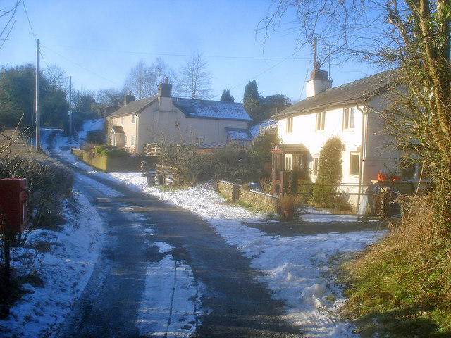
Lower Hergest is a small rural village located in the county of Herefordshire, England. Situated in the heart of the beautiful Welsh Marches, it lies approximately 5 miles northwest of the town of Kington. The village is nestled in a picturesque valley, surrounded by rolling hills and offering stunning views of the Herefordshire countryside.

Lower Hergest is characterized by its peaceful and idyllic setting, making it a popular destination for nature lovers and those seeking a tranquil retreat. The village is predominantly residential, with a small number of houses and cottages scattered throughout the area.

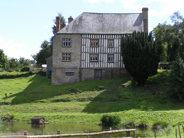
One of the notable features of Lower Hergest is Hergest Court, a magnificent country house that dates back to the 18th century. The house is set within extensive grounds, including a beautiful walled garden that is open to the public during certain times of the year. Visitors can explore the gardens, which are renowned for their variety of rare and exotic plants.

The village is also home to Hergest Ridge, a prominent hill that offers panoramic views of the surrounding landscape. It has become a popular spot for walkers and hikers, who can enjoy the tranquil atmosphere and stunning vistas.

Although Lower Hergest is a small village, it benefits from its proximity to nearby towns and amenities. The town of Kington provides a range of services, including shops, schools, and healthcare facilities, ensuring that residents have access to all necessary amenities.

Overall, Lower Hergest offers a charming and peaceful rural retreat, where visitors can immerse themselves in the natural beauty of Herefordshire and enjoy a sense of tranquility away from the hustle and bustle of urban life.

If you have any feedback on the listing, please let us know in the comments section below.

Lower Hergest Images

Images are sourced within 2km of 52.192411/-3.0601847 or Grid Reference SO2755. Thanks to Geograph Open Source API. All images are credited.

Offa's Dyke Path on Hergest Ridge Looking east over a vast landscape. It is just possible to make out the Malvern Hills towards the right on the skyline. The town of Kington in the middle distance.
Offa's Dyke Path on Hergest Ridge
Looking east over a vast landscape. It is just possible to make out the Malvern Hills towards the right on the skyline. The town of Kington in the middle distance.
View north from Hergest Ridge Dunfield Farm <a href="https://www.geograph.org.uk/gridref/SO2758">SO2758</a> can be seen in the valley with Herrock Hill <a href="https://www.geograph.org.uk/gridref/SO2759">SO2759</a> beyond.
View north from Hergest Ridge
Dunfield Farm SO2758 can be seen in the valley with Herrock Hill SO2759 beyond.
Cutting bracken on Hergest Ridge
One man and his dog Out for a walk on Offa's Dyke Path on Hergest Ridge.
One man and his dog
Out for a walk on Offa's Dyke Path on Hergest Ridge.
Offa's Dyke Path on Hergest Ridge
Out for a walk The section of Offa's Dyke Path on Hergest Ridge is extremely popular with walkers.
Out for a walk
The section of Offa's Dyke Path on Hergest Ridge is extremely popular with walkers.
"Welcome to Kington" Notice that greets Offa's Dyke walkers coming down off the bridleway on the Hergest Ridge in to Winterbourne Road in Kington. The town describes itself as "the centre for walking".
"Welcome to Kington"
Notice that greets Offa's Dyke walkers coming down off the bridleway on the Hergest Ridge in to Winterbourne Road in Kington. The town describes itself as "the centre for walking".
"Thank you for visiting Kington" Notice that bids farewell to Offa's Dyke walkers coming up from Winterbourne Road in Kington on to the bridleway on the Hergest Ridge. Kington describes itself as "the centre for walking".
"Thank you for visiting Kington"
Notice that bids farewell to Offa's Dyke walkers coming up from Winterbourne Road in Kington on to the bridleway on the Hergest Ridge. Kington describes itself as "the centre for walking".
Wind sculpture in Hergest Croft Gardens This finely balanced sculpture has three moving parts which rotate with the wind.
Wind sculpture in Hergest Croft Gardens
This finely balanced sculpture has three moving parts which rotate with the wind.
"Origin" Sculpture by Rolf Hook made from  Ledbury Yew (whatever that might be), standing in Hergest Croft Gardens.
"Origin"
Sculpture by Rolf Hook made from Ledbury Yew (whatever that might be), standing in Hergest Croft Gardens.
"Nascence" Sculpture by Rolf Hook made from  Ledbury Yew (whatever that might be), standing in Hergest Croft Gardens.
"Nascence"
Sculpture by Rolf Hook made from Ledbury Yew (whatever that might be), standing in Hergest Croft Gardens.
Stamping station, Offa's Dyke Path For those who wish to authenticate their walk along Offa's Dyke Path, this stamping station is provided beside the path into Hergest Croft Gardens.
Stamping station, Offa's Dyke Path
For those who wish to authenticate their walk along Offa's Dyke Path, this stamping station is provided beside the path into Hergest Croft Gardens.
View to Herrick Hill View to Herrick Hill from Offa's Dyke Path crossing Hergest Ridge. Bradnor Hill is on the right in the middle distance.
View to Herrick Hill
View to Herrick Hill from Offa's Dyke Path crossing Hergest Ridge. Bradnor Hill is on the right in the middle distance.
View north from Hergest Ridge The wooded hill in the middle distance is Navages Wood.  This hill includes Stanners Rocks which at 700 million years old are among the oldest rocks in Wales.
View north from Hergest Ridge
The wooded hill in the middle distance is Navages Wood. This hill includes Stanners Rocks which at 700 million years old are among the oldest rocks in Wales.
Ridgebourne Road Offa's Dyke Path follows Ridgebourne Road as it descends from Hergest Ridge into Kington.
Ridgebourne Road
Offa's Dyke Path follows Ridgebourne Road as it descends from Hergest Ridge into Kington.
Toll House, Kington "The Toll House". In Hergest Road in front Hergest Mill. Erected by the Kington Turnpike Trust in the 19ᵗʰ C. More local toll houses see <a title="https://www.geograph.org.uk/discuss/index.php?&action=vthread&forum=11&topic=33104" href="https://www.geograph.org.uk/discuss/index.php?&action=vthread&forum=11&topic=33104">Link</a>


Milestone Society National ID: HF.KIN04
Toll House, Kington
"The Toll House". In Hergest Road in front Hergest Mill. Erected by the Kington Turnpike Trust in the 19ᵗʰ C. More local toll houses see Link Milestone Society National ID: HF.KIN04
Toll House, Kington "The Toll House" on the A44 NW of Kington in the area known as Floodgates. Erected by the Kington Turnpike Trust in the 19ᵗʰ C. More local toll houses see <a title="https://www.geograph.org.uk/discuss/index.php?&action=vthread&forum=11&topic=33104" href="https://www.geograph.org.uk/discuss/index.php?&action=vthread&forum=11&topic=33104">Link</a>


Milestone Society National ID: HF.KIN01
Toll House, Kington
"The Toll House" on the A44 NW of Kington in the area known as Floodgates. Erected by the Kington Turnpike Trust in the 19ᵗʰ C. More local toll houses see Link Milestone Society National ID: HF.KIN01
Wych House, Kington Dates from the early nineteenth century <span class="nowrap"><a title="https://historicengland.org.uk/listing/the-list/list-entry/1208078?section=official-list-entry" rel="nofollow ugc noopener" href="https://historicengland.org.uk/listing/the-list/list-entry/1208078?section=official-list-entry">Link</a><img style="margin-left:2px;" alt="External link" title="External link - shift click to open in new window" src="https://s1.geograph.org.uk/img/external.png" width="10" height="10"/></span>
Wych House, Kington
Dates from the early nineteenth century LinkExternal link
Show me another place!

Lower Hergest is located at Grid Ref: SO2755 (Lat: 52.192411, Lng: -3.0601847)

Unitary Authority: County of Herefordshire

Police Authority: West Mercia

What 3 Words

///cards.pencils.simulates. Near Kington, Herefordshire

Related Wikis

Lower Hergest

Lower Hergest is a hamlet in Herefordshire, England.The local manor house, Hergest Court, is a Grade II* listed building built of a mixture of stone and...

Kington Rural

Kington Rural is a civil parish in west Herefordshire, England, and is approximately 17 miles (30 km) north-west from the city and county town of Hereford...

Upper Hergest

Upper Hergest is a hamlet in Herefordshire, England. == References ==

Lady Hawkins' School

Lady Hawkins' School is a 11-16 secondary school in Kington, Herefordshire. The headteacher is Paul Jennings.The school comprises two houses named after...

Nearby Amenities

Located within 500m of 52.192411,-3.0601847
Lower Hergest
Place: hamlet
Source: OS_OpenData_StreetView
Wikidata: Q20592843
Lat/Long: 52.1925712/-3.0605131
Information: guidepost
Tourism: information
Lat/Long: 52.1892903/-3.0651488
Barrier: stile
Material: metal
Stile: squeezer
Lat/Long: 52.1926363/-3.0596929
Castle Twts
Place: locality
Lat/Long: 52.1928239/-3.0588953
Crossing
Crossing: unmarked
Lat/Long: 52.1905716/-3.0582188
Depth: 0.25
Ford: yes
Lat/Long: 52.190372/-3.0586423
Barrier: stile
Lat/Long: 52.1895484/-3.0589745
Entrance: yes
Lat/Long: 52.1903798/-3.0567188
Barrier: stile
Lat/Long: 52.1905069/-3.0585509
Crossing
Crossing: unmarked
Lat/Long: 52.1904951/-3.0584901
Barrier: swing_gate
Lat/Long: 52.1907535/-3.0629878
Barrier: stile
Note: 2021: this stile has a 4-ft drop on the East side. It is also in poor repair.
Stile: stepover
Lat/Long: 52.1902169/-3.0623075
Barrier: stile
Lat/Long: 52.1904017/-3.0608801
Information: guidepost
Tourism: information
Lat/Long: 52.1905667/-3.0604773
Information: guidepost
Tourism: information
Lat/Long: 52.1905698/-3.0600431
Information: guidepost
Tourism: information
Lat/Long: 52.1905375/-3.0597406
Barrier: stile
Stile: squeezer
Lat/Long: 52.195329/-3.0588217
Barrier: stile
Stile: squeezer
Lat/Long: 52.195043/-3.0590497
Barrier: stile
Material: wood
Stile: squeezer
Lat/Long: 52.1935616/-3.0592685
Ford: yes
Lat/Long: 52.1934432/-3.0592375
Tourism: viewpoint
Lat/Long: 52.1927523/-3.0590806
Barrier: stile
Material: wood
Stile: stepover
Lat/Long: 52.1904621/-3.0569219
The data included in this document is from www.openstreetmap.org. The data is made available under ODbL.

Have you been to Lower Hergest?

Leave your review of Lower Hergest below (or comments, questions and feedback).