Rubha nan Lion

Coastal Marsh, Saltings in Ross-shire

Scotland

Rubha nan Lion

B8011 at Leathad Mòr
B8011 at Leathad Mòr Credit: Sandy Gerrard

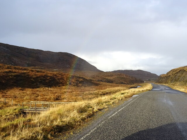
Rubha nan Lion, located in Ross-shire, Scotland, is a coastal marshland characterized by its unique saltings. The site is situated on a peninsula that juts out into the North Atlantic Ocean, providing stunning views of the surrounding seascape. The area is known for its diverse range of flora and fauna, making it a popular destination for nature enthusiasts and birdwatchers.

The marshland at Rubha nan Lion is composed of a mixture of salt-tolerant grasses, sedges, and rushes that thrive in the brackish conditions. These wetland plants create a complex ecosystem, providing habitat and food sources for various bird species, including wading birds, waterfowl, and seabirds. The area is particularly important for breeding and wintering birds, as it offers protection and abundant foraging opportunities.

The coastal location also attracts a variety of marine life. Seals can often be spotted basking on the rocks, while dolphins and porpoises occasionally swim close to the shore. The intertidal zone of the saltings is home to a range of invertebrates, such as crabs, mollusks, and worms, which play a vital role in the marshland's ecological balance.

In addition to its natural beauty, Rubha nan Lion has cultural significance. The site has historical remnants, including the remains of a medieval chapel and a nearby lighthouse, which adds to its charm and allure.

Overall, Rubha nan Lion in Ross-shire offers a captivating blend of coastal landscapes, diverse wildlife, and historical elements, making it a captivating destination for those seeking to immerse themselves in nature and Scottish heritage.

If you have any feedback on the listing, please let us know in the comments section below.

Rubha nan Lion Images

Images are sourced within 2km of 58.188915/-6.9309004 or Grid Reference NB1032. Thanks to Geograph Open Source API. All images are credited.

B8011 at Leathad Mòr
An Sùileachan Monument A monument to the Lewis land clearances <span class="nowrap"><a title="https://bhaltostrust.co.uk/suileachan-project/" rel="nofollow ugc noopener" href="https://bhaltostrust.co.uk/suileachan-project/">Link</a><img style="margin-left:2px;" alt="External link" title="External link - shift click to open in new window" src="https://s1.geograph.org.uk/img/external.png" width="10" height="10"/></span>
An Sùileachan Monument
A monument to the Lewis land clearances LinkExternal link
Derelict house on slope of Beinn a' Ghlinne Ruaidh
Geisiadar On Croft Number 8 - The Crofting Commission are looking to evict the tenant of this croft and destroy the woods.
Geisiadar
On Croft Number 8 - The Crofting Commission are looking to evict the tenant of this croft and destroy the woods.
Lochan at Cragavig An old boundary wall snakes across the moorland
Lochan at Cragavig
An old boundary wall snakes across the moorland
Cerishader: postbox № HS2 158 A small postbox on the B8011, with its back to Loch Ròg. It is emptied at 9 o'clock each morning, except Sunday.
Cerishader: postbox № HS2 158
A small postbox on the B8011, with its back to Loch Ròg. It is emptied at 9 o'clock each morning, except Sunday.
Carishader postbox The sea inlet is part of Loch Ròg.
Carishader postbox
The sea inlet is part of Loch Ròg.
Old black house walls, Cairisiadar Looking up An Gleann Ruadh.
Old black house walls, Cairisiadar
Looking up An Gleann Ruadh.
Abhainn Mhòr a' Ghlinne Ruaidh
Bridge over the Abhainn Mhor a' Ghlinne Ruaidh
A hint of a rainbow by Abhainn Mhòr a Ghlinne Ruaidh Just cross the footbridge and you are at the end of the rainbow (now where's my shovel!).
A hint of a rainbow by Abhainn Mhòr a Ghlinne Ruaidh
Just cross the footbridge and you are at the end of the rainbow (now where's my shovel!).
Name That Tune This cheerful accordionist stands just inside a field by the cattle grid on the B8011 north of Cairisiadar. The label at his feet reads 'Name That Tune'.
Name That Tune
This cheerful accordionist stands just inside a field by the cattle grid on the B8011 north of Cairisiadar. The label at his feet reads 'Name That Tune'.
Cairisiadar (Carishader) Though the B8011 has been much improved, there are still some single-track stretches, notably where it crosses narrow bridges which have not been rebuilt, as here at Cairisiadar.
Cairisiadar (Carishader)
Though the B8011 has been much improved, there are still some single-track stretches, notably where it crosses narrow bridges which have not been rebuilt, as here at Cairisiadar.
Miabhaig harbour pontoon View from RIB afloat to pontoon at Miabhaig, Ceann A Tuath Na Hearadh (North Harris).  Compare to <a href="https://www.geograph.org.uk/photo/575251">NB0934 : Miabhaig Jetty</a> taken by Dave Fergusson on 1 Oct 2007.
Miabhaig harbour pontoon
View from RIB afloat to pontoon at Miabhaig, Ceann A Tuath Na Hearadh (North Harris). Compare to NB0934 : Miabhaig Jetty taken by Dave Fergusson on 1 Oct 2007.
If you are ever up this way... RIB moored alongside Miabhaig pontoon <a href="https://www.geograph.org.uk/photo/2429707">NB0934 : Miabhaig harbour pontoon</a> on Ceann A Tuath Na Hearadah (North Harris) from which we enjoyed a great trip.  (No financial benefit in anyway to me from posting this; simply a community service.)
If you are ever up this way...
RIB moored alongside Miabhaig pontoon NB0934 : Miabhaig harbour pontoon on Ceann A Tuath Na Hearadah (North Harris) from which we enjoyed a great trip. (No financial benefit in anyway to me from posting this; simply a community service.)
Join the Band Name That Tune and take a seat to have your photograph taken with the band at Carishader / Cairisiadar. Maybe it's Heather and Pete playing the field.
Join the Band
Name That Tune and take a seat to have your photograph taken with the band at Carishader / Cairisiadar. Maybe it's Heather and Pete playing the field.
Sheep Pens at Carishader One of many roadside pens on Lewis where sheep farming is a major agricultural industry.
Sheep Pens at Carishader
One of many roadside pens on Lewis where sheep farming is a major agricultural industry.
Show me another place!

Rubha nan Lion is located at Grid Ref: NB1032 (Lat: 58.188915, Lng: -6.9309004)

Unitary Authority: Na h-Eileanan an Iar

Police Authority: Highlands and Islands

What 3 Words

///mostly.lease.remaining. Near Carloway, Na h-Eileanan Siar

Related Wikis

Flodaigh, Lewis

Flodaigh is a small island in Loch Roag on the west coast of Lewis in the Outer Hebrides of Scotland. It is about 33 hectares (82 acres) in extent and...

Fuaigh Beag

Fuaigh Beag or Vuia Be(a)g is an island in the Outer Hebrides. It is off the west coast of Lewis near Great Bernera in Loch Roag. Its name means "little...

Loch na Berie

Loch Na Berie is a broch in the Outer Hebrides of Scotland, located approximately 400 yards from the shore, and is thought to have been located on an island...

Loch Ròg

Loch Ròg or Loch Roag is a large sea loch on the west coast of Lewis, Outer Hebrides. It is broadly divided into East Loch Roag and West Loch Roag with...

Fuaigh Mòr

Fuaigh Mòr (sometimes anglicised as Vuia Mor) is an island in the Outer Hebrides of Scotland. It is off the west coast of Lewis near Great Bernera in...

Cliff, Lewis

Cliff (Scottish Gaelic: Cliobh) is a small settlement on the Isle of Lewis, in the Outer Hebrides, Scotland. Cliff is within the parish of Uig. The settlement...

Kneep

Kneep (Scottish Gaelic: Cnìp) is a village on the Isle of Lewis, in the Outer Hebrides, Scotland. Kneep is within the parish of Uig.Various archaeological...

Vacsay

Vacsay (Scottish Gaelic: Bhacsaigh from Old Norse "bakkiey" meaning "peat bank island") is one of the Outer Hebrides. It is off the west coast of Lewis...

Related Videos

Reef Beach #short Isle Of Harris

The Crystal clear water on Reef beach in the Isle of Harris Check my other videos out for a longer flight Please like and Subscribe ...

Driving on Country Roads in Uigen Isle of Lewis Scotland

Driving up from the beach in the evening light in Outer Hebrides, Sept. 2023.

Nearby Amenities

Located within 500m of 58.188915,-6.9309004
Passing Place
Lat/Long: 58.185188/-6.9334825
Ele: 122
Natural: peak
Source: OS7
Lat/Long: 58.1851532/-6.9278866
Post Box
Carishader
Collection Times: Mo-Fr 10:15; Sa 10:15
Operator: Royal Mail
Post Box Type: lamp
Ref: HS2 158
Royal Cypher: scottish_crown
Source: survey
Lat/Long: 58.1904868/-6.9365692
Cairisiadar
Name En: Carishader
Name Gd: Cairisiadar
Place: village
Lat/Long: 58.1908178/-6.936825
Power: pole
Lat/Long: 58.1853908/-6.9341988
Power: pole
Lat/Long: 58.1861821/-6.9345667
Power: pole
Lat/Long: 58.186965/-6.9349391
Power: pole
Lat/Long: 58.1875506/-6.9352219
Power: pole
Lat/Long: 58.1879832/-6.9354217
Power: pole
Lat/Long: 58.188782/-6.9356259
Power: pole
Lat/Long: 58.1891265/-6.9359388
Power: pole
Lat/Long: 58.1899691/-6.9367064
Power: pole
Lat/Long: 58.1903046/-6.9370088
Power: pole
Lat/Long: 58.1907153/-6.9374399
Power: pole
Lat/Long: 58.1910471/-6.937753
Power: pole
Lat/Long: 58.1874695/-6.9343387
Power: pole
Lat/Long: 58.1878787/-6.9344155
Power: pole
Lat/Long: 58.1881738/-6.9346096
Power: pole
Lat/Long: 58.1895102/-6.936576
Power: pole
Lat/Long: 58.1895491/-6.93634
Power: pole
Lat/Long: 58.1889461/-6.9358625
Power: pole
Lat/Long: 58.1884109/-6.9356104
Power: pole
Lat/Long: 58.1884039/-6.9352698
Power: pole
Lat/Long: 58.1900227/-6.9372238
Power: pole
Lat/Long: 58.1906646/-6.9380365
Passing Place
Lat/Long: 58.1912112/-6.9374171
The data included in this document is from www.openstreetmap.org. The data is made available under ODbL.

Have you been to Rubha nan Lion?

Leave your review of Rubha nan Lion below (or comments, questions and feedback).