Leathad Rèidh

Coastal Marsh, Saltings in Ross-shire

Scotland

Leathad Rèidh

Mullach na h-Airde Bige Second HuMP around the northern edge of Loch Resort on an Alan Holmes RIB trip. What a brilliant day.
Name: Mullach na h-Airde Bige
Hill number: 4947
Height: 182m / 597ft
Area: 24A: Lewis and Nearby Islands
Class: Hu,1
Grid ref: NB026188 (est)
Drop: 128m
Col: 54m  NB044194
Mullach na h-Airde Bige Credit: Rude Health

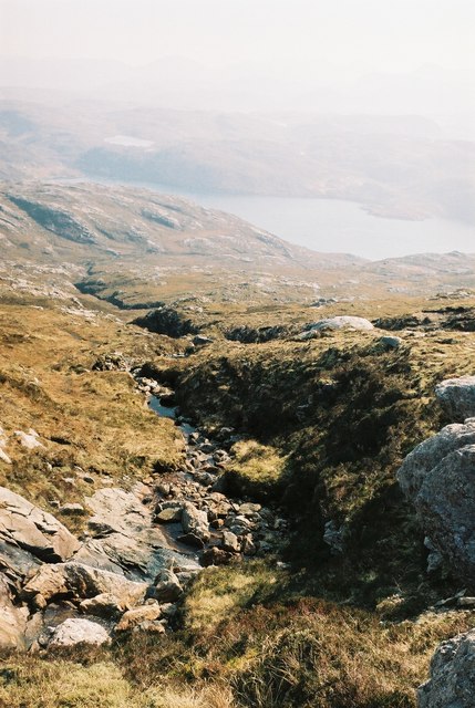
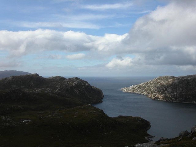
Leathad Rèidh is a coastal marshland located in Ross-shire, Scotland. Situated along the coast, it encompasses an area of diverse salt marshes and saltings. The site is known for its unique ecological characteristics and is of significant importance for both wildlife and conservation.

The marshland is characterized by its flat, low-lying terrain, which is often flooded by tidal waters. This creates a dynamic ecosystem that supports a wide range of plant and animal species. The vegetation in Leathad Rèidh includes various types of salt-tolerant plants, such as samphire, sea lavender, and saltmarsh grasses. These plants provide critical habitats and feeding grounds for numerous bird species, including waders and migrating waterfowl.

Leathad Rèidh is a designated Special Protection Area (SPA) and a Site of Special Scientific Interest (SSSI), reflecting its importance for bird populations and its ecological significance. It is also recognized as a Ramsar site, highlighting its international importance as a wetland habitat.

Visitors to Leathad Rèidh can enjoy its natural beauty and observe the diverse wildlife that inhabits the area. The marshland provides excellent opportunities for birdwatching, with the possibility of spotting species such as redshanks, oystercatchers, and curlews. The surrounding coastal landscape offers stunning views and opportunities for coastal walks.

Efforts are made to protect and preserve the delicate balance of Leathad Rèidh's ecosystem. Conservation management practices, including controlling grazing levels and managing water levels, are implemented to maintain and enhance the biodiversity of the area.

If you have any feedback on the listing, please let us know in the comments section below.

Leathad Rèidh Images

Images are sourced within 2km of 58.068264/-7.0323329 or Grid Reference NB0319. Thanks to Geograph Open Source API. All images are credited.

Mullach na h-Airde Bige Second HuMP around the northern edge of Loch Resort on an Alan Holmes RIB trip. What a brilliant day.
Name: Mullach na h-Airde Bige
Hill number: 4947
Height: 182m / 597ft
Area: 24A: Lewis and Nearby Islands
Class: Hu,1
Grid ref: NB026188 (est)
Drop: 128m
Col: 54m  NB044194
Mullach na h-Airde Bige
Second HuMP around the northern edge of Loch Resort on an Alan Holmes RIB trip. What a brilliant day. Name: Mullach na h-Airde Bige Hill number: 4947 Height: 182m / 597ft Area: 24A: Lewis and Nearby Islands Class: Hu,1 Grid ref: NB026188 (est) Drop: 128m Col: 54m NB044194
Steep Climb From Landing Point For Mullach na h-Airde Bige Our boatman Neil was a little worried by the steep climb up from our landing point. It proved to be no problem for Douglas Law, Alan Holmes, George Morl, Michael Earnshaw, Jim Bloomer, Martin Richardson, Mark Smith, Richard Tibbetts and Colin Crawford who were soon on top of the HuMP, Mullach na h-Airde Bige.
Steep Climb From Landing Point For Mullach na h-Airde Bige
Our boatman Neil was a little worried by the steep climb up from our landing point. It proved to be no problem for Douglas Law, Alan Holmes, George Morl, Michael Earnshaw, Jim Bloomer, Martin Richardson, Mark Smith, Richard Tibbetts and Colin Crawford who were soon on top of the HuMP, Mullach na h-Airde Bige.
Eoranish More Bagged on a RIB trip with 8 others to the HuMPs north of Loch Resort. Looking west towards Mullach na h-Airde Bige.
Name: Eoranish More
Hill number: 104363
Height: 158m / 518ft
Area: 24A: Lewis and Nearby Islands
Class: 1
Grid ref: NB032188 (est)
Drop: 79m
Col: 79m
Eoranish More
Bagged on a RIB trip with 8 others to the HuMPs north of Loch Resort. Looking west towards Mullach na h-Airde Bige. Name: Eoranish More Hill number: 104363 Height: 158m / 518ft Area: 24A: Lewis and Nearby Islands Class: 1 Grid ref: NB032188 (est) Drop: 79m Col: 79m
View Across Loch Gruineabhat View across Loch Gruineabhat and beyond to the subHuMP Aineabhal which is the next hill on our bagging list today.
View Across Loch Gruineabhat
View across Loch Gruineabhat and beyond to the subHuMP Aineabhal which is the next hill on our bagging list today.
Crossing Damp Moorland Crossing damp moorland after descending from Eoranish More and heading towards Aineabhal.
Crossing Damp Moorland
Crossing damp moorland after descending from Eoranish More and heading towards Aineabhal.
House and Outbuildings at Tamnabhaigh
Loch Tamnabhaigh Aird Bheag to left of image and Tamana Sear to right
Loch Tamnabhaigh
Aird Bheag to left of image and Tamana Sear to right
Loch Cheann Chuisil This sheltered loch offers anchorage during stormy weather
Loch Cheann Chuisil
This sheltered loch offers anchorage during stormy weather
Burn flowing into Gleann Sgaladail
The head of Gleann Sgaladail The lower picture shows ruined shielings with a burn running through.
The head of Gleann Sgaladail
The lower picture shows ruined shielings with a burn running through.
Ruined shielings in Gleann Sgaladail
Gleann Sgaladail burn meets Loch Tamnabhaigh
Moorland above Loch Tamnabhaigh
Bridge over Abhainn Tamnabhaig
Mol Tealasbhaigh Even in this remote inlet on the Atlantic Western Seaboard of Harris there is much evidence of plastic litter
Mol Tealasbhaigh
Even in this remote inlet on the Atlantic Western Seaboard of Harris there is much evidence of plastic litter
Aird Bheag Number 1 Aird Bheag on the shore of Loch Hamnaway
Aird Bheag
Number 1 Aird Bheag on the shore of Loch Hamnaway
Ard Bheag Landing Place This is the point where stores etc are landed for the house at Ard Bheag. A rough and very ancient and fairly steep path leads from the sea up to the house.
Ard Bheag Landing Place
This is the point where stores etc are landed for the house at Ard Bheag. A rough and very ancient and fairly steep path leads from the sea up to the house.
Loch Thamnabhaigh Entrance A sheltered sealoch and anchorage in south west Lewis.
Loch Thamnabhaigh Entrance
A sheltered sealoch and anchorage in south west Lewis.
Show me another place!

Leathad Rèidh is located at Grid Ref: NB0319 (Lat: 58.068264, Lng: -7.0323329)

Unitary Authority: Na h-Eileanan an Iar

Police Authority: Highlands and Islands

What 3 Words

///dates.gown.emulating. Near Tarbert, Na h-Eileanan Siar

Related Wikis

Mealista

Mealista (Scottish Gaelic: Mealasta) was a township in the west of the Isle of Lewis. It is currently largely uninhabited due to the Highland Clearances...

Game pieces of the Lewis chessmen hoard

Game pieces of the Lewis chessmen hoard include the ninety-three game pieces of the Lewis chessmen hoard found on the Isle of Lewis in the Outer Hebrides...

Eilean Mhealasta

Eilean Mhealasta (Mealista Island) is an uninhabited island off the west coast of Lewis in the Outer Hebrides of Scotland. It takes its name from Mealista...

Scarp, Scotland

Scarp (Scottish Gaelic: An Sgarp) is an uninhabited island in the Outer Hebrides of Scotland, west of Hushinish on Harris. Once inhabited, the island was...

Nearby Amenities

Located within 500m of 58.068264,-7.0323329
Tob Cul na h-Airde Bige
Natural: bay
Lat/Long: 58.066964/-7.035142
Loch Tamnabhaigh
Natural: bay
Lat/Long: 58.0702779/-7.0362364
Aird Sleitinis
Natural: cape
Lat/Long: 58.0670221/-7.0381429
Tatarol
Place: locality
Lat/Long: 58.0653219/-7.0328126
The data included in this document is from www.openstreetmap.org. The data is made available under ODbL.

Have you been to Leathad Rèidh?

Leave your review of Leathad Rèidh below (or comments, questions and feedback).