Beachy Head

Coastal Feature, Headland, Point in Sussex Eastbourne

England

Beachy Head

Pinnacle Point, Holywell Eroded cliffs and the footpath to the beach. Looking south.
Pinnacle Point, Holywell Credit: Simon Carey

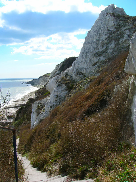
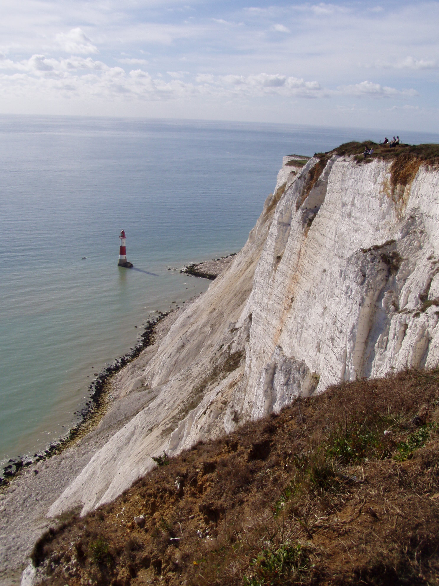
Beachy Head is a prominent headland located on the South Coast of England in East Sussex. It is situated about 3.2 kilometers west of the town of Eastbourne and stands at an impressive height of 162 meters (530 feet) above sea level. This iconic coastal feature is part of the South Downs National Park and is renowned for its breathtaking views and dramatic cliffs.

The cliffs at Beachy Head are composed of chalk, giving them a distinctive white appearance that contrasts beautifully with the blue waters of the English Channel. These cliffs are the highest chalk sea cliffs in Britain and are a popular destination for hikers, birdwatchers, and nature enthusiasts. The area is home to a diverse range of flora and fauna, including several rare and endangered species.

Aside from its natural beauty, Beachy Head also holds historical significance. The headland was used as a defensive fortification during World War II and remnants of gun placements can still be seen today. Additionally, during the 19th century, the area became notorious for its shipwrecks, earning it the nickname "mariners' graveyard."

Beachy Head is a place of both natural and historical importance, attracting thousands of visitors each year. It offers a variety of recreational activities, such as hiking along the South Downs Way, birdwatching, or simply enjoying the stunning panoramic views. However, it is important to note that due to the height of the cliffs and the nature of the terrain, caution must be exercised when visiting Beachy Head to ensure personal safety.

If you have any feedback on the listing, please let us know in the comments section below.

Beachy Head Images

Images are sourced within 2km of 50.736351/0.25068659 or Grid Reference TV5895. Thanks to Geograph Open Source API. All images are credited.

Pinnacle Point, Holywell Eroded cliffs and the footpath to the beach. Looking south.
Pinnacle Point, Holywell
Eroded cliffs and the footpath to the beach. Looking south.
The seashore near to Holywell This photo was taken during a late night crabbing expedition (this is where you might end up if you hit your golf ball too hard from the pitch and putt at Helen Gardens!).
The seashore near to Holywell
This photo was taken during a late night crabbing expedition (this is where you might end up if you hit your golf ball too hard from the pitch and putt at Helen Gardens!).
The Beach off Holywell This was taken at night and shows how beautiful the coastline really is when most people are tucked up in the bi - bi ! and never see it in this way.
The Beach off Holywell
This was taken at night and shows how beautiful the coastline really is when most people are tucked up in the bi - bi ! and never see it in this way.
Pinnacle Point Viewed from the beach at low tide with the steps to the beach in front of it.
Pinnacle Point
Viewed from the beach at low tide with the steps to the beach in front of it.
Cliffs at Holywell Near to the steps to the beach and taken at low tide next to the western most groyne along Eastbourne's seafront. The cliffs behind have 'slumped' due to landslides, a feature of the cliffline between Holywell and Cow Gap.
Cliffs at Holywell
Near to the steps to the beach and taken at low tide next to the western most groyne along Eastbourne's seafront. The cliffs behind have 'slumped' due to landslides, a feature of the cliffline between Holywell and Cow Gap.
Beach at Holywell Taken at low tide with Cow Gap in the distance.
Beach at Holywell
Taken at low tide with Cow Gap in the distance.
Foyle Way Track linking Dukes Drive to the playing fields at Whitbread Hole.
Foyle Way
Track linking Dukes Drive to the playing fields at Whitbread Hole.
Cliff Top footpath At Holywell area
Cliff Top footpath
At Holywell area
Eastbourne Beach From Holywell area
Eastbourne Beach
From Holywell area
Eastbourne Coastline South of Holywell
Eastbourne Coastline
South of Holywell
Pinnacle Point, Eastbourne This crumbling chalk cliff appears, like a mini mountain, above the beach.  A set of steps, followed by a winding path, lead up towards the outskirts of Eastbourne.  The alternative route, at low tide, is to walk along the beach.
Pinnacle Point, Eastbourne
This crumbling chalk cliff appears, like a mini mountain, above the beach. A set of steps, followed by a winding path, lead up towards the outskirts of Eastbourne. The alternative route, at low tide, is to walk along the beach.
Beach at Holywell, Eastbourne Anyone interested in rock pools, might well find this beach of interest, at low tide.  However; the main beach, near Eastbourne, would be more enticing for anyone wishing to bathe.  The view, here, is towards Cow Gap.
Beach at Holywell, Eastbourne
Anyone interested in rock pools, might well find this beach of interest, at low tide. However; the main beach, near Eastbourne, would be more enticing for anyone wishing to bathe. The view, here, is towards Cow Gap.
Steep climb on the South Downs Way
Foreshore, Holywell, Eastbourne Looking along towards Cow Gap.
Foreshore, Holywell, Eastbourne
Looking along towards Cow Gap.
Holywell Ledge The far reef, submerged at higher tides. It is Upper Greensand.
Holywell Ledge
The far reef, submerged at higher tides. It is Upper Greensand.
Remains of groyne, Holywell This is the southernmost groyne here. It appears on maps in the second half of the 20th century. This basically concrete abutment to the cliff looks to have had a sort of stone sett facing to the concrete which has not weathered too well - neither has the cliff.
Remains of groyne, Holywell
This is the southernmost groyne here. It appears on maps in the second half of the 20th century. This basically concrete abutment to the cliff looks to have had a sort of stone sett facing to the concrete which has not weathered too well - neither has the cliff.
Foyle Way, Eastbourne
Pinnacle Point, Holywell, Eastbourne This photo shows Pinnacle Point which is alternatively known as "Gibraltar" and the "Sugar Loaf". The top of Pinnacle Point can be accessed by a path on the landward side which is visible in the photo.
Pinnacle Point, Holywell, Eastbourne
This photo shows Pinnacle Point which is alternatively known as "Gibraltar" and the "Sugar Loaf". The top of Pinnacle Point can be accessed by a path on the landward side which is visible in the photo.
Show me another place!

Beachy Head is located at Grid Ref: TV5895 (Lat: 50.736351, Lng: 0.25068659)

Administrative County: East Sussex

District: Eastbourne

Police Authority: Sussex

What 3 Words

///storming.agreement.unsigned. Near Eastbourne, East Sussex

Nearby Locations

Beachy Head

Related Wikis

RAF Beachy Head

RAF Beachy Head is a former Royal Air Force radar station and one of the many Chain Home Low radar stations, being situated near Beachy Head and Eastbourne...

Beachy Head

Beachy Head is a chalk headland in East Sussex, England. It is situated close to Eastbourne, immediately east of the Seven Sisters. Beachy Head is located...

Action of 2 May 1707

The action of 2 May 1707, also known as Beachy Head, was a naval battle of the War of the Spanish Succession in which a French squadron under Claude de...

Beachy Head Lighthouse

Beachy Head Lighthouse is a lighthouse located in the English Channel below the cliffs of Beachy Head in East Sussex. It is 33 m (108 ft) in height and...
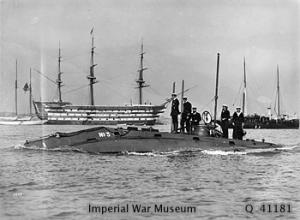
HMS Holland 5

Holland 5 was the last of the five Holland-class submarines ordered by the British Admiralty to evaluate the potential of the submarine with the Royal...

Murder of Jessie Earl

Jessie Earl (16 December 1957 – between 15 and 18 May 1980) was a 22-year-old student who disappeared from Eastbourne, England in May 1980. It was not...

Meads

Meads is an area of the town of Eastbourne in the English county of East Sussex. It is situated at the westerly end of the town below the South Downs....

MT Sitakund

Sitakund was a Norwegian motor oil tanker owned by Tschudi & Eitzen was sailing from Wilhelmshaven to Libya on 20 October 1968, when three explosions occurred...

Nearby Amenities

Located within 500m of 50.736351,0.25068659
Created By: almien_coastlines
Source: PGS
Lat/Long: 50.735143/0.245698
Source: PGS
Lat/Long: 50.7353506/0.2462468
Source: PGS
Lat/Long: 50.7355659/0.2476075
Bus Stop
Beachy Head
Bench: no
Bin: no
Bus: yes
Lit: no
Public Transport: platform
Shelter: no
Tactile Paving: no
Lat/Long: 50.7389653/0.2484262
Bus Stop
Beachy Head Hotel
Bench: yes
Bin: no
Bus: yes
Lit: no
Public Transport: platform
Shelter: no
Tactile Paving: no
Lat/Long: 50.7398574/0.2519749
Restaurant
Beachy Head
Addr Postcode: BN20 7YA
Addr Street: Beachy Head Road
Alt Name: Beachy Head Hotel
Brand: Vintage Inns
Brand Wikidata: Q87067899
Contact Website: https://www.vintageinn.co.uk/restaurants/south-east/thebeachyheadeastbourne
Lat/Long: 50.7402033/0.2515295
Beachy Head
Natural: cliff
Website: https://www.beachyhead.org.uk/
Wikidata: Q812895
Wikipedia: en:Beachy Head
Lat/Long: 50.738185/0.2494669
Post Box
Beachy Head
Brand: Royal Mail
Brand Wikidata: Q638098
Check Date Collection Times: 2022-05-25
Collection Times: Mo-Fr 17:00; Sa 11:00
Operator: Royal Mail
Operator Wikidata: Q638098
Post Box Type: lamp
Ref: BN20 709
Royal Cypher: EIIR
Royal Cypher Wikidata: Q33102113
Source: survey
Lat/Long: 50.7404607/0.2518763
Free Flying Site: takeoff
Sport: free_flying
Lat/Long: 50.7400306/0.2530797
OS marker
Historic: boundary_stone
Lat/Long: 50.7399524/0.2526032
Information: map
Tourism: information
Lat/Long: 50.7395731/0.2526579
Bus Stop
Beachy Head
Bench: no
Bin: no
Bus: yes
Lit: no
Public Transport: platform
Shelter: no
Tactile Paving: no
Lat/Long: 50.7390216/0.2474812
Vending Machine
Vending: parking_tickets
Lat/Long: 50.738821/0.2466351
Tourism: viewpoint
Lat/Long: 50.73893/0.2462502
Man Made: mast
Tower Type: communication
Lat/Long: 50.7407374/0.2520919
The data included in this document is from www.openstreetmap.org. The data is made available under ODbL.

Have you been to Beachy Head?

Leave your review of Beachy Head below (or comments, questions and feedback).