Barkie

Coastal Feature, Headland, Point in Shetland

Scotland

Barkie

Loch of Birriesgirt The north shore of this remote lake. In the distance you can see there is not much separating it from the cliff edge and the sea.
Loch of Birriesgirt Credit: Des Blenkinsopp

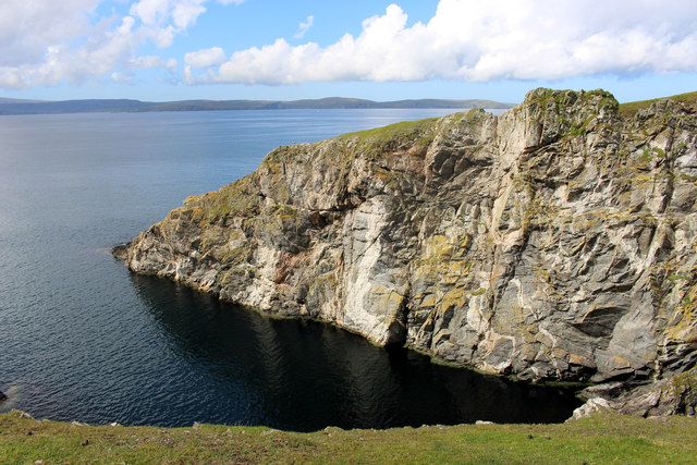
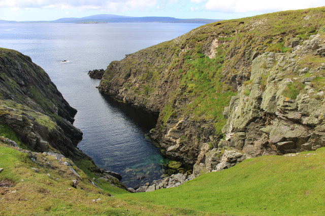
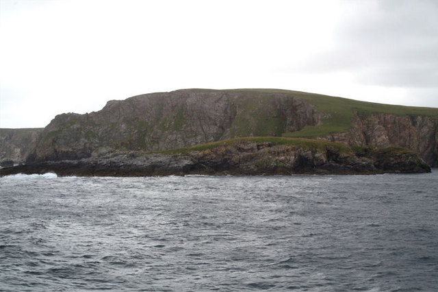
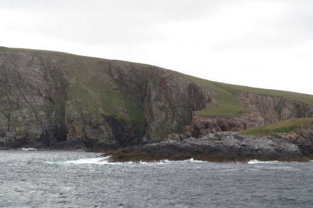
Barkie is a prominent coastal feature located in Shetland, an archipelago in Scotland. It is classified as a headland or point, extending out into the North Sea. Situated on the eastern coast of Shetland, Barkie offers stunning views of the surrounding rugged coastline and the vast expanse of the sea.

The headland is formed by layers of sedimentary rocks, primarily sandstone and shale, which have been shaped over thousands of years by the relentless forces of erosion. This geological composition gives Barkie its distinct appearance, characterized by tall cliffs and exposed rock formations.

Barkie is known for its diverse wildlife, attracting nature enthusiasts and birdwatchers from around the world. The surrounding coastal waters are home to a variety of seabirds, including puffins, guillemots, and razorbills. Visitors can witness these magnificent creatures nesting and diving into the sea in search of fish.

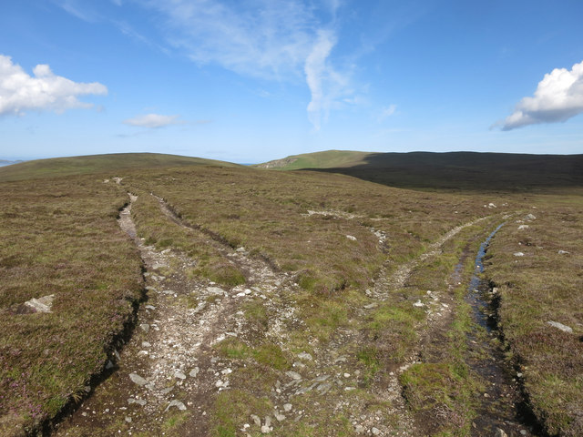
The headland is also a popular spot for coastal walks and hiking trails. A well-maintained path leads visitors along the rugged coastline, offering breathtaking views and opportunities to explore the nearby beaches and coves. The area is rich in flora and fauna, with wildflowers and grasses dotting the landscape.

Barkie is easily accessible by road, with nearby parking facilities available for visitors. The headland is a perfect destination for those seeking solitude and tranquility, as it is relatively untouched and less crowded compared to other tourist spots in Shetland.

Overall, Barkie is a remarkable coastal feature in Shetland, offering a unique blend of natural beauty, wildlife, and recreational opportunities for all who venture to this remote part of Scotland.

If you have any feedback on the listing, please let us know in the comments section below.

Barkie Images

Images are sourced within 2km of 60.602167/-1.2003058 or Grid Reference HU4391. Thanks to Geograph Open Source API. All images are credited.

Loch of Birriesgirt The north shore of this remote lake. In the distance you can see there is not much separating it from the cliff edge and the sea.
Loch of Birriesgirt
The north shore of this remote lake. In the distance you can see there is not much separating it from the cliff edge and the sea.
Towards Varnadil Not too bad walking around here. Mostly grassy, with scrubby heather in places, and a lot of sheep tracks to help visitors.
This was one of the wet bits.
Towards Varnadil
Not too bad walking around here. Mostly grassy, with scrubby heather in places, and a lot of sheep tracks to help visitors. This was one of the wet bits.
Barkie, of Birrier, Barkie and Slog There are three of these promontories side by side along here named Birrier, Barkie and Slog, like a firm of dodgy solicitors.
This is Barkie, the middle one.
Barkie, of Birrier, Barkie and Slog
There are three of these promontories side by side along here named Birrier, Barkie and Slog, like a firm of dodgy solicitors. This is Barkie, the middle one.
Birrier, of Birrier, Barkie and Slog There are three of these promontories side by side along here named Birrier, Barkie and Slog, like a firm of dodgy solicitors.
This is Birrier, the northern one.
Birrier, of Birrier, Barkie and Slog
There are three of these promontories side by side along here named Birrier, Barkie and Slog, like a firm of dodgy solicitors. This is Birrier, the northern one.
Slog, of Birrier, Barkie and Slog There are three of these promontories side by side along here named Birrier, Barkie and Slog, like a firm of dodgy solicitors.
This is Slog, the southern one.
Slog, of Birrier, Barkie and Slog
There are three of these promontories side by side along here named Birrier, Barkie and Slog, like a firm of dodgy solicitors. This is Slog, the southern one.
High Road or Low Road The high road looked the better option, although it wasn't shown on the map, but it petered out after about 1/4 mile.
High Road or Low Road
The high road looked the better option, although it wasn't shown on the map, but it petered out after about 1/4 mile.
A Small Loch Nameless on the 1:25000 sheet, but at maximum zoom on the input map the name Loch of Lungasta Quhamm appears.
A fine big name for quite a small loch.
A Small Loch
Nameless on the 1:25000 sheet, but at maximum zoom on the input map the name Loch of Lungasta Quhamm appears. A fine big name for quite a small loch.
Sky & Stones, Mill Loch
Arch on the Holm of West Sandwick At the north end of the island. Taken from one of the Yell Sound ferries on a North Isles cruise.
Arch on the Holm of West Sandwick
At the north end of the island. Taken from one of the Yell Sound ferries on a North Isles cruise.
Cliffs at the Head Just north of West Sandwick. Taken from one of the Yell Sound ferries on a North Isles cruise.
Cliffs at the Head
Just north of West Sandwick. Taken from one of the Yell Sound ferries on a North Isles cruise.
Birrier There is apparently an ancient settlement on this promontory. Taken from one of the Yell Sound ferries on a North Isles cruise.
Birrier
There is apparently an ancient settlement on this promontory. Taken from one of the Yell Sound ferries on a North Isles cruise.
Sweinna Stack With the hill of Varnadil. Taken from one of the Yell Sound ferries on a North Isles cruise.
Sweinna Stack
With the hill of Varnadil. Taken from one of the Yell Sound ferries on a North Isles cruise.
Sweinna Stack The tongue of land behind the stack gives an idea of the topography of the land before erosion. Taken from one of the Yell Sound ferries on a North Isles cruise.
Sweinna Stack
The tongue of land behind the stack gives an idea of the topography of the land before erosion. Taken from one of the Yell Sound ferries on a North Isles cruise.
Point of Bugarth The two small stacks offshore which form the extreme of the headland are in the square. The Hill of Rulkie behind is in the next square. Taken from one of the Yell Sound ferries on a North Isles cruise.
Point of Bugarth
The two small stacks offshore which form the extreme of the headland are in the square. The Hill of Rulkie behind is in the next square. Taken from one of the Yell Sound ferries on a North Isles cruise.
Rulkies Hill, Graveland
Sweinna Stack
Sweinna Stack
Sweinna Stack
Sweinna Stack
Sweinna Stack from the south
Show me another place!

Barkie is located at Grid Ref: HU4391 (Lat: 60.602167, Lng: -1.2003058)

Unitary Authority: Shetland Islands

Police Authority: Highlands and Islands

What 3 Words

///fattest.absent.scar. Near Ulsta, Shetland Islands

Related Wikis

West Sandwick

West Sandwick is a settlement on the island of Yell, Shetland Islands, Scotland. It is one of the few settlements in the west of the island. West Sandwick...

Muckle Holm, Yell Sound

Muckle Holm is a small island in Shetland. It is in Yell Sound, near the Northmavine. It is 23 metres (75 ft) at its highest point. There is a lighthouse...

Yell Sound

Yell Sound is the strait running between Yell and Mainland, Shetland, Scotland. It is the boundary between the Mainland and the North Isles and it contains...

Ern Stack

Ern Stack is a sea stack off Yell, in Shetland, Scotland. The word "ern" means an eagle (it is a cognate of, for example, Swedish "örn"), and it is said...

Yell, Shetland

Yell (Scots: Yell) is one of the North Isles of Shetland, Scotland. In the 2011 census it had a usually resident population of 966. It is the second largest...

Little Holm, Yell Sound

Little Holm is a small island in Yell Sound, in Shetland, Scotland. It lies between Northmavine and the island of Yell. There is a lighthouse here. In...

Fethaland

Fethaland or Fedeland (pronounced [ˈfeɪdələnd]) is an abandoned settlement at the extreme north end of Mainland, Shetland. It was the site of the largest...

Mid Yell

Mid Yell is a coastal settlement on the island of Yell, the second largest of Shetland Islands, Scotland. Mid Yell, the largest settlement on the island...

Have you been to Barkie?

Leave your review of Barkie below (or comments, questions and feedback).