Baa Taing

Coastal Feature, Headland, Point in Shetland

Scotland

Baa Taing

Ness of Hillwick Taken from the B9078 between Burnside and Eshaness, Shetland, I am looking across Sand Wick to the Ness of Hillswick. The Isle of Westerhouse is visible just off the Pund of Grevasand to the west of the Ness.
Ness of Hillwick Credit: Carroll Pierce

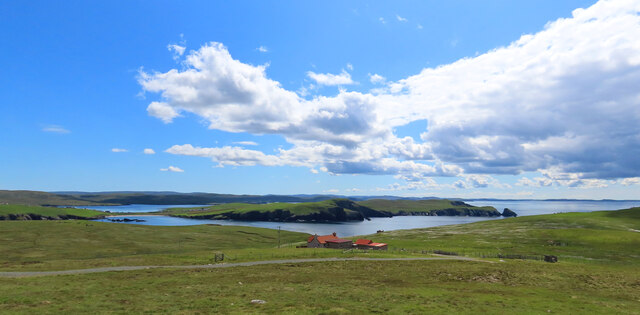
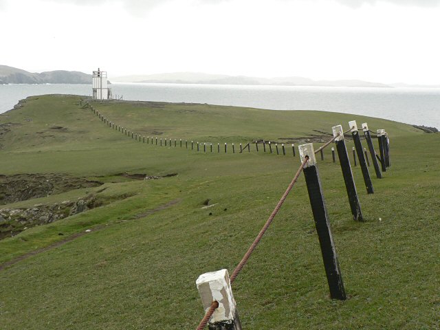
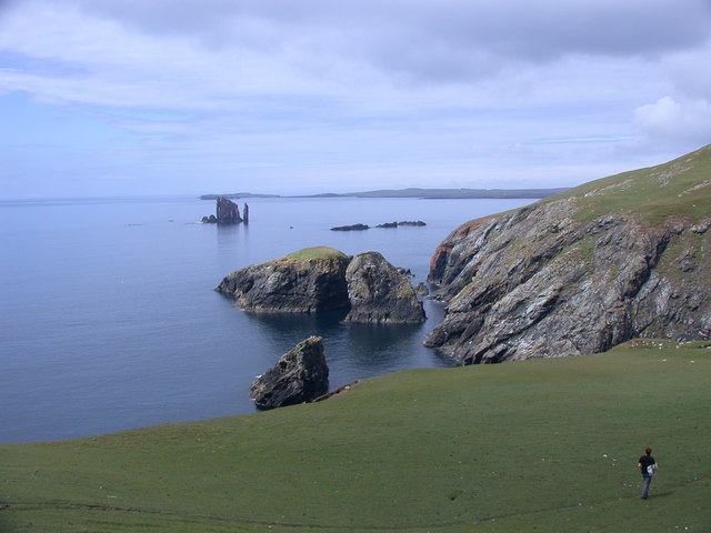
Baa Taing is a prominent coastal feature located on the west coast of the Shetland Islands, Scotland. It is a picturesque headland that juts out into the North Atlantic Ocean, offering stunning views of the surrounding landscape.

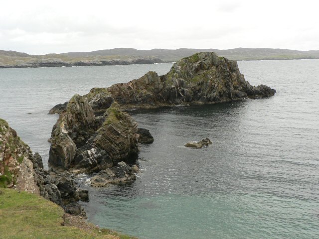
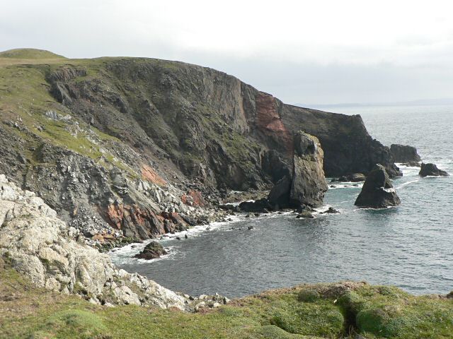
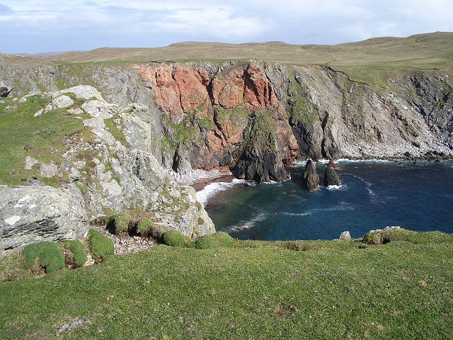
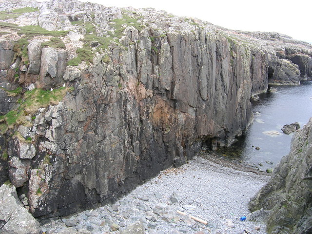
Situated near the village of Walls, Baa Taing is characterized by its rugged and rocky terrain. The headland is composed of layered rock formations, showcasing the geological history of the area. These layers, formed over millions of years, provide an insight into the region's ancient past.

Baa Taing is known for its dramatic cliffs, which rise up to considerable heights. These cliffs are home to a variety of seabirds, including puffins, gannets, and kittiwakes. Birdwatchers flock to the area to witness the impressive displays of these avian inhabitants.

The headland also boasts a small pebble beach, where visitors can relax and enjoy the peacefulness of the coastal environment. The beach is a great spot for rock pooling, as it teems with marine life during low tide.

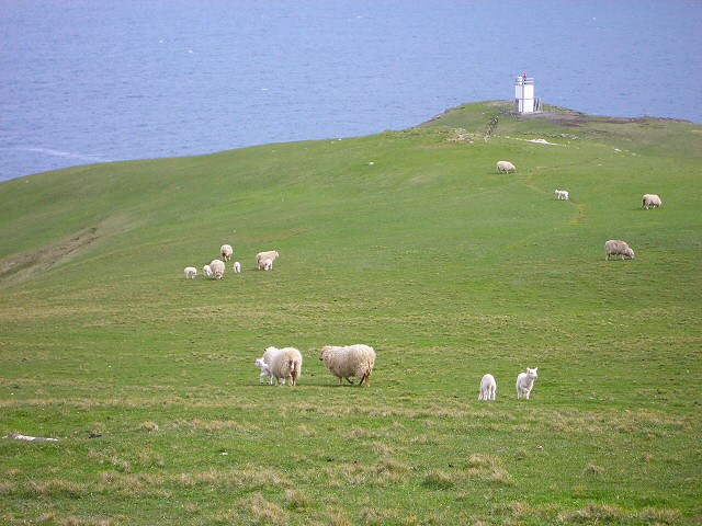
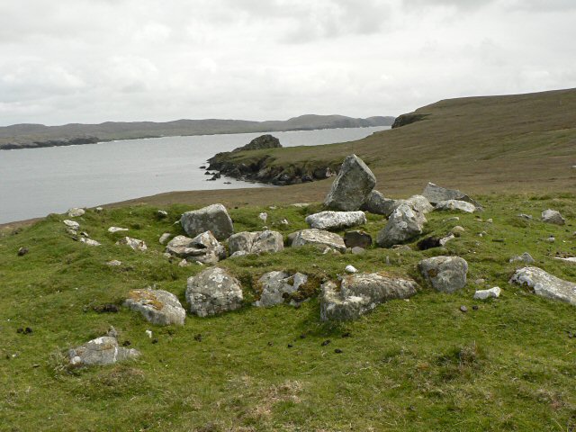
In addition to its natural beauty, Baa Taing is steeped in local folklore and history. The name "Baa Taing" is derived from the Old Norse language, meaning "sheep field." This reflects the area's historical use as grazing land for sheep.

Overall, Baa Taing is a captivating coastal feature that showcases the stunning natural wonders and cultural heritage of the Shetland Islands. Its unique geological formations, diverse birdlife, and rich history make it a must-visit destination for nature enthusiasts and history buffs alike.

If you have any feedback on the listing, please let us know in the comments section below.

Baa Taing Images

Images are sourced within 2km of 60.452793/-1.4974347 or Grid Reference HU2774. Thanks to Geograph Open Source API. All images are credited.

Ness of Hillwick Taken from the B9078 between Burnside and Eshaness, Shetland, I am looking across Sand Wick to the Ness of Hillswick. The Isle of Westerhouse is visible just off the Pund of Grevasand to the west of the Ness.
Ness of Hillwick
Taken from the B9078 between Burnside and Eshaness, Shetland, I am looking across Sand Wick to the Ness of Hillswick. The Isle of Westerhouse is visible just off the Pund of Grevasand to the west of the Ness.
The Quilse
The Quilse
Gordi Stack This is the stack seen edge on. From other directions it looks much wider. In the distance to the right are the Drongs - another dramatic rock formation. See <a href="https://www.geograph.org.uk/photo/550985">HU2675 : The Drongs</a> for an telephoto view.
Gordi Stack
This is the stack seen edge on. From other directions it looks much wider. In the distance to the right are the Drongs - another dramatic rock formation. See HU2675 : The Drongs for an telephoto view.
Cliffs and stack The view south from this point is spectacular.

(The stack and the point to the right lie in this grid square, while the cliff to the left is in <a href="https://www.geograph.org.uk/gridref/HU2775">HU2775</a>).
Cliffs and stack
The view south from this point is spectacular. (The stack and the point to the right lie in this grid square, while the cliff to the left is in HU2775).
Sheep near Baa Taing Looking down the sheep pasture towards the lighthouse.
Sheep near Baa Taing
Looking down the sheep pasture towards the lighthouse.
Baa Taing light A rope handrail provides safe access to the light in bad weather. The headland is wide and flat, so the conditions that might require the safety rail defy imagination.
Baa Taing light
A rope handrail provides safe access to the light in bad weather. The headland is wide and flat, so the conditions that might require the safety rail defy imagination.
Lochan and cliffs Looking across the lochan at the south end of Hillswick Ness, backed by the cliffs above Queen Geos.
Lochan and cliffs
Looking across the lochan at the south end of Hillswick Ness, backed by the cliffs above Queen Geos.
Opposite a red cliff Looking across the short turf of this promontory at a red cliff across the bay.
Opposite a red cliff
Looking across the short turf of this promontory at a red cliff across the bay.
Neolithic house The outline of this ancient building is easier to see on the ground than it appears in this photo.
Neolithic house
The outline of this ancient building is easier to see on the ground than it appears in this photo.
Cairn These are the remains of a prehistoric burial mound.
Cairn
These are the remains of a prehistoric burial mound.
Remains of township There was a crofting township here. This is the remains of a pond, and beyond are the outlines of buildings.
Remains of township
There was a crofting township here. This is the remains of a pond, and beyond are the outlines of buildings.
Ness of Hillswick, SW coastal cliffs SW cliffs of Ness of Hillswick on right, Isle of Niddister in centre. The Drongs <a href="https://www.geograph.org.uk/gridref/HU2675">HU2675</a> rock stacks beyond, with the South edge of Esha Ness on the horizon to their left.
Ness of Hillswick, SW coastal cliffs
SW cliffs of Ness of Hillswick on right, Isle of Niddister in centre. The Drongs HU2675 rock stacks beyond, with the South edge of Esha Ness on the horizon to their left.
Medusa Walls, Hamar Medusa isn't the local name for the geo, it doesn't appear to have one. The wall was named Medusa from the name of a climb that takes the wall just above the start of the beach at the sea line. It was first climbed in 2005 on the day this photo was taken.
Medusa Walls, Hamar
Medusa isn't the local name for the geo, it doesn't appear to have one. The wall was named Medusa from the name of a climb that takes the wall just above the start of the beach at the sea line. It was first climbed in 2005 on the day this photo was taken.
Natural Arch on east coast of Ness of Hillswick A natural arch which probably hasn't that long (in geological terms) before it becomes an isolated stack. It provided us with a little entertainment later in the week when the weather had calmed down enough to paddle round Ness of Hillswick in sea kayaks. Although the water looks flat here, this is simply because Ura Firth is quite sheltered and the wind blowing away from the photographer. The southern and western sides of the Ness were getting a big swell on the day this view was seen, and it was still too windy to venture out in small boats.
Natural Arch on east coast of Ness of Hillswick
A natural arch which probably hasn't that long (in geological terms) before it becomes an isolated stack. It provided us with a little entertainment later in the week when the weather had calmed down enough to paddle round Ness of Hillswick in sea kayaks. Although the water looks flat here, this is simply because Ura Firth is quite sheltered and the wind blowing away from the photographer. The southern and western sides of the Ness were getting a big swell on the day this view was seen, and it was still too windy to venture out in small boats.
Stack of Niddister The Stack of Niddister (seen here from a peninsula which juts out southeast into Ura Firth from the Ness of Hillswick) is not really what most people would think of as a sea stack - its sides are not vertical and it is vegetated. Not enough grass to graze a sheep on, though, so it qualifies as a skerry rather than an island. The Ness is composed of a series of highly metamorphosed rocks, almost vertically bedded, forming a group of peninsulas all pointing southeast and somewhat broken into skerries with a few natural arches and sea caves - a great place to  play in sea kayaks when the weather allows. On this particular day it was very windy, and the southern and western parts of the Ness were exposed to a substantial swell - hence why we were walking rather than paddling !
Stack of Niddister
The Stack of Niddister (seen here from a peninsula which juts out southeast into Ura Firth from the Ness of Hillswick) is not really what most people would think of as a sea stack - its sides are not vertical and it is vegetated. Not enough grass to graze a sheep on, though, so it qualifies as a skerry rather than an island. The Ness is composed of a series of highly metamorphosed rocks, almost vertically bedded, forming a group of peninsulas all pointing southeast and somewhat broken into skerries with a few natural arches and sea caves - a great place to play in sea kayaks when the weather allows. On this particular day it was very windy, and the southern and western parts of the Ness were exposed to a substantial swell - hence why we were walking rather than paddling !
Ness of Hillswick lighthouse and Baa Taing Not obvious from the path to the lighthouse, but visible from the continuing path towards Gordi Stack, is the arch in Baa Taing, seen here as a white spot in the headland. Although Ura Firth had seemed calm, once onto the southern side of Ness of Hillswick, the power of the swell from the heavy weather two days earlier became obvious (this is why we were walking round the Ness, and not paddling sea kayaks). The waves are breaking ferociously over the rocky skerries below the Taing and a gusty wind was keeping us well away from the cliff edge. The lighthouse is approached on a path which, at first glance, has a fence alongside. Closer inspection shows that the fence is not there to keep livestock from straying, but is a single heavy cable anchored to a series of posts, presumably to give some security to anyone who has to come and do maintenance on the lighthouse during a storm.

Beyond the Firth is south Mainland and the Isle of Nibon, another area with many stacks and caves to keep the sea paddler entertained, but quite unapproachable in these conditions.
Ness of Hillswick lighthouse and Baa Taing
Not obvious from the path to the lighthouse, but visible from the continuing path towards Gordi Stack, is the arch in Baa Taing, seen here as a white spot in the headland. Although Ura Firth had seemed calm, once onto the southern side of Ness of Hillswick, the power of the swell from the heavy weather two days earlier became obvious (this is why we were walking round the Ness, and not paddling sea kayaks). The waves are breaking ferociously over the rocky skerries below the Taing and a gusty wind was keeping us well away from the cliff edge. The lighthouse is approached on a path which, at first glance, has a fence alongside. Closer inspection shows that the fence is not there to keep livestock from straying, but is a single heavy cable anchored to a series of posts, presumably to give some security to anyone who has to come and do maintenance on the lighthouse during a storm. Beyond the Firth is south Mainland and the Isle of Nibon, another area with many stacks and caves to keep the sea paddler entertained, but quite unapproachable in these conditions.
Isle of Niddister and Windy Geo Below the cliffs of the Ness of Hillswick lies a fantastic playground of stacks and geos to keep the sea kayaker entertained for hours.  However, only the very brave or foolhardy would be down there in a big swell and gusty wind such as we found on our walking visit (even days later when things had improved immensely, we were forced to keep clear of these rocks). The biggest of these skerries is the Isle of Niddister, though it scarcely looks big enough to graze a sheep (the criterion which distinguishes an island from a skerry) and getting one up there (and not blown away) would be challenging.

The Ness, and these skerries, are made of steeply dipping metamorphic rocks, particularly visible in the cliffs on the right. Out in the wild sea lie the Drongs, of an entirely different geological period, dramatic granite stacks a kilometre offshore. In the distance beyond them is the big headland of Esha Ness.
Isle of Niddister and Windy Geo
Below the cliffs of the Ness of Hillswick lies a fantastic playground of stacks and geos to keep the sea kayaker entertained for hours. However, only the very brave or foolhardy would be down there in a big swell and gusty wind such as we found on our walking visit (even days later when things had improved immensely, we were forced to keep clear of these rocks). The biggest of these skerries is the Isle of Niddister, though it scarcely looks big enough to graze a sheep (the criterion which distinguishes an island from a skerry) and getting one up there (and not blown away) would be challenging. The Ness, and these skerries, are made of steeply dipping metamorphic rocks, particularly visible in the cliffs on the right. Out in the wild sea lie the Drongs, of an entirely different geological period, dramatic granite stacks a kilometre offshore. In the distance beyond them is the big headland of Esha Ness.
Isle of Westerhouse The Pund of Grevasand is the westernmost peninsula of the Ness of Hillswick and is separated from the Isle of Westerhouse by Houlma Sound. The nearer skerry is Herta Stack, whilst Isle of Westerhouse itself is surrounded by smaller skerries, of which Lunga skerries, The Snuildies, Bio Stack, The Spindle and many smaller rocks are seen in this view. These have all been separated from the Ness along lines of weakness in the steeply dipping (almost vertical) metamorphic rocks which make up the Ness. In the distance, a kilometre offshore, the dramatic stacks of The Drongs are composed of an entirely different (and much younger) rock - granite, which is significantly more able to resist the battering of Atlantic swell. The Drongs are an irresistible target for sea kayakers, but would have to wait a few days before we were able to visit, in much calmer conditions.
Isle of Westerhouse
The Pund of Grevasand is the westernmost peninsula of the Ness of Hillswick and is separated from the Isle of Westerhouse by Houlma Sound. The nearer skerry is Herta Stack, whilst Isle of Westerhouse itself is surrounded by smaller skerries, of which Lunga skerries, The Snuildies, Bio Stack, The Spindle and many smaller rocks are seen in this view. These have all been separated from the Ness along lines of weakness in the steeply dipping (almost vertical) metamorphic rocks which make up the Ness. In the distance, a kilometre offshore, the dramatic stacks of The Drongs are composed of an entirely different (and much younger) rock - granite, which is significantly more able to resist the battering of Atlantic swell. The Drongs are an irresistible target for sea kayakers, but would have to wait a few days before we were able to visit, in much calmer conditions.
Show me another place!

Baa Taing is located at Grid Ref: HU2774 (Lat: 60.452793, Lng: -1.4974347)

Unitary Authority: Shetland Islands

Police Authority: Highlands and Islands

What 3 Words

///brand.hardly.inherits. Near Brae, Shetland Islands

Related Wikis

The Drongs

The Drongs are a group of sea stacks off the coast of Hillswick Ness, Northmavine, Shetland, Scotland. They lie to the west of the Isle of Westerhouse...

Hillswick

Hillswick is a small village in Northmavine, on the shore of the Atlantic Ocean and lies to the north-north west of Mainland, Shetland, the most northerly...

Gunnister

Gunnister is a small 'abandoned' village at the North-West Mainland in Shetland, Scotland. It is most commonly known for the Gunnister Man - the remains...

Punds Water

Punds Water is a freshwater loch near Mangaster in Northmavine, Shetland. It also gives its name to a nearby Neolithic heel-shaped cairn. == Heel-shaped... ==

Nearby Amenities

Located within 500m of 60.452793,-1.4974347
Man Made: lighthouse
Seamark Light 1 Character: Fl
Seamark Light 1 Colour: white
Seamark Light 1 Group: 4
Seamark Light 1 Height: 34
Seamark Light 1 Period: 15
Seamark Light 1 Range: 9
Seamark Light 1 Sector End: 93
Seamark Light 1 Sector Start: 217
Seamark Light 1 Sequence: 1+(2),1+(2),1+(2),1+(5)
Seamark Light 2 Character: Fl
Seamark Light 2 Colour: red
Seamark Light 2 Group: 4
Seamark Light 2 Height: 34
Seamark Light 2 Period: 15
Seamark Light 2 Range: 6
Seamark Light 2 Sector End: 114
Seamark Light 2 Sector Start: 93
Seamark Light 2 Sequence: 1+(2),1+(2),1+(2),1+(5)
Seamark Light Reference: A 3840
Seamark Type: light_minor
Source: US NGA Pub. 114. 2011-05-26.
Lat/Long: 60.4535/-1.4964667
The data included in this document is from www.openstreetmap.org. The data is made available under ODbL.

Have you been to Baa Taing?

Leave your review of Baa Taing below (or comments, questions and feedback).