Burton, Lower

Settlement in Herefordshire

England

Burton, Lower

A4112 in Stockingfield
A4112 in Stockingfield Credit: Colin Pyle

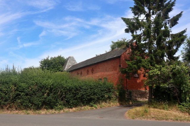
Burton is a small village located in the county of Herefordshire, England. Situated in the lower region of the county, it is part of the civil parish of Lower. The village is nestled amidst the picturesque countryside and is surrounded by lush green fields and rolling hills.

Burton is known for its peaceful and idyllic setting, offering residents and visitors a tranquil escape from the hustle and bustle of city life. The village consists of a cluster of charming cottages, some of which date back several centuries, adding to the area's historical charm.

The heart of Burton is centered around the village church, which stands as a prominent landmark. The church, dedicated to St. Michael and All Angels, is a fine example of medieval architecture and attracts visitors with its beautiful stained glass windows and intricate stonework.

The village also boasts a community hall, which serves as a hub for various local events and gatherings. The hall hosts a range of activities, including art exhibitions, music concerts, and social gatherings, fostering a sense of community spirit among the residents.

Surrounded by natural beauty, Burton offers ample opportunities for outdoor activities. The village is located near several walking trails and is a popular starting point for hikers exploring the nearby countryside. The serene surroundings also make it an ideal location for picnics and nature enthusiasts.

Overall, Burton, Lower, Herefordshire is a charming and serene village, offering its residents and visitors a peaceful retreat in the heart of the English countryside.

If you have any feedback on the listing, please let us know in the comments section below.

Burton, Lower Images

Images are sourced within 2km of 52.199166/-2.8500305 or Grid Reference SO4256. Thanks to Geograph Open Source API. All images are credited.

A4112 in Stockingfield
Oast House Twin round kiln oast house.
Oast House
Twin round kiln oast house.
View to Oast House
View to Oast House
View to Oast House
View to Oast House
View to Oast House
View to Oast House
Land awaiting development Land awaiting development on the west side of the village of Dilwyn.
Land awaiting development
Land awaiting development on the west side of the village of Dilwyn.
Land awaiting development Land awaiting development on the west side of the village of Dilwyn.
Land awaiting development
Land awaiting development on the west side of the village of Dilwyn.
Knight's tomb, Dilwyn church The identity of this knight is not certain, it may be Sir Gilbert Talbot, 3rd Baron Talbot of Goodrich.  He served under John of Gaunt during his invasion of Castille; he died in Castille in 1387.
Knight's tomb, Dilwyn church
The identity of this knight is not certain, it may be Sir Gilbert Talbot, 3rd Baron Talbot of Goodrich. He served under John of Gaunt during his invasion of Castille; he died in Castille in 1387.
Knight's memorial, Dilwyn church The identity of this knight is not certain, it may be Sir Gilbert Talbot, 3rd Baron Talbot of Goodrich.  He served under John of Gaunt during his invasion of Castille; he died in Castille in 1387. Note the ball flowers, a particular feature of the English Decorated style of architect in Herefordshire.
Knight's memorial, Dilwyn church
The identity of this knight is not certain, it may be Sir Gilbert Talbot, 3rd Baron Talbot of Goodrich. He served under John of Gaunt during his invasion of Castille; he died in Castille in 1387. Note the ball flowers, a particular feature of the English Decorated style of architect in Herefordshire.
St Mary’s C of E Primary School The school building in Dilwyn was building in the early 19th century.  The building has a rather grand porch which appears a little oversized when compared with the building.  The school is Grade II listed, see: <span class="nowrap"><a title="https://historicengland.org.uk/listing/the-list/list-entry/1301584?section=official-list-entry" rel="nofollow ugc noopener" href="https://historicengland.org.uk/listing/the-list/list-entry/1301584?section=official-list-entry">Link</a><img style="margin-left:2px;" alt="External link" title="External link - shift click to open in new window" src="https://s1.geograph.org.uk/img/external.png" width="10" height="10"/></span>
St Mary’s C of E Primary School
The school building in Dilwyn was building in the early 19th century. The building has a rather grand porch which appears a little oversized when compared with the building. The school is Grade II listed, see: LinkExternal link
Porch of Dilwyn church The late C15 or early C16 porch of St Mary's church, Dilwyn.  The church is Grade I listed, see: <span class="nowrap"><a title="https://historicengland.org.uk/listing/the-list/list-entry/1349814?section=official-list-entry" rel="nofollow ugc noopener" href="https://historicengland.org.uk/listing/the-list/list-entry/1349814?section=official-list-entry">Link</a><img style="margin-left:2px;" alt="External link" title="External link - shift click to open in new window" src="https://s1.geograph.org.uk/img/external.png" width="10" height="10"/></span>
Porch of Dilwyn church
The late C15 or early C16 porch of St Mary's church, Dilwyn. The church is Grade I listed, see: LinkExternal link
The village of Dilwyn View across the village green in Dilwyn to a row of timber-framed cottages.
The village of Dilwyn
View across the village green in Dilwyn to a row of timber-framed cottages.
The spire of Dilwyn church A glimpse of the spire of St Mary's church, Dilwyn.
The spire of Dilwyn church
A glimpse of the spire of St Mary's church, Dilwyn.
The Great House The Great House is probably timber-framed and dating from the 17th century, with an 18th century Georgian brick facade.  The house is Grade II listed, see: <span class="nowrap"><a title="https://historicengland.org.uk/listing/the-list/list-entry/1349815?section=official-list-entry" rel="nofollow ugc noopener" href="https://historicengland.org.uk/listing/the-list/list-entry/1349815?section=official-list-entry">Link</a><img style="margin-left:2px;" alt="External link" title="External link - shift click to open in new window" src="https://s1.geograph.org.uk/img/external.png" width="10" height="10"/></span>  The Tyler family lived here in the 18th century, the poet Robert Southey was a distant relative through marriage and stayed here.
The Great House
The Great House is probably timber-framed and dating from the 17th century, with an 18th century Georgian brick facade. The house is Grade II listed, see: LinkExternal link The Tyler family lived here in the 18th century, the poet Robert Southey was a distant relative through marriage and stayed here.
Henwood Henwood, an 18th century Georgian house near Dilwyn.  The house is Grade II listed, see: <span class="nowrap"><a title="https://historicengland.org.uk/listing/the-list/list-entry/1081929?section=official-list-entry" rel="nofollow ugc noopener" href="https://historicengland.org.uk/listing/the-list/list-entry/1081929?section=official-list-entry">Link</a><img style="margin-left:2px;" alt="External link" title="External link - shift click to open in new window" src="https://s1.geograph.org.uk/img/external.png" width="10" height="10"/></span>
Henwood
Henwood, an 18th century Georgian house near Dilwyn. The house is Grade II listed, see: LinkExternal link
Timber Framed houses and barn at Karen Court <span class="nowrap"><a title="https://historicengland.org.uk/listing/the-list/list-entry/1081941?section=official-list-entry" rel="nofollow ugc noopener" href="https://historicengland.org.uk/listing/the-list/list-entry/1081941?section=official-list-entry">Link</a><img style="margin-left:2px;" alt="External link" title="External link - shift click to open in new window" src="https://s1.geograph.org.uk/img/external.png" width="10" height="10"/></span>
Timber Framed houses and barn at Karen Court
Church of St Mary <span class="nowrap"><a title="https://historicengland.org.uk/listing/the-list/list-entry/1349814?section=official-list-entry" rel="nofollow ugc noopener" href="https://historicengland.org.uk/listing/the-list/list-entry/1349814?section=official-list-entry">Link</a><img style="margin-left:2px;" alt="External link" title="External link - shift click to open in new window" src="https://s1.geograph.org.uk/img/external.png" width="10" height="10"/></span>
Church of St Mary
Old Milestone by the former A4112, Dilwyn Metal plate detached from post, by the UC road (was A4112), in parish of Dilwyn (District), by North entrance to churchyard, high on the stone retaining wall, on West side of road. Previously located further North, and still shown at that location on maps up to 1983/4. Parton Stone, erected by the Monkland & Parton turnpike trust in the 19th century. 

Inscription reads:-
Lemster
6
Miles

Herefordshire SMR listed.
SMR Number: 56720 <span class="nowrap"><a title="https://www.heritagegateway.org.uk/Gateway/Results_Single.aspx?uid=MHE28476&resourceID=101" rel="nofollow ugc noopener" href="https://www.heritagegateway.org.uk/Gateway/Results_Single.aspx?uid=MHE28476&resourceID=101">Link</a><img style="margin-left:2px;" alt="External link" title="External link - shift click to open in new window" src="https://s1.geograph.org.uk/img/external.png" width="10" height="10"/></span>

Milestone Society National ID: HF_LMHY06
Old Milestone by the former A4112, Dilwyn
Metal plate detached from post, by the UC road (was A4112), in parish of Dilwyn (District), by North entrance to churchyard, high on the stone retaining wall, on West side of road. Previously located further North, and still shown at that location on maps up to 1983/4. Parton Stone, erected by the Monkland & Parton turnpike trust in the 19th century. Inscription reads:- Lemster 6 Miles Herefordshire SMR listed. SMR Number: 56720 LinkExternal link Milestone Society National ID: HF_LMHY06
Show me another place!

Burton, Lower is located at Grid Ref: SO4256 (Lat: 52.199166, Lng: -2.8500305)

Unitary Authority: County of Herefordshire

Police Authority: West Mercia

What 3 Words

///maps.pushover.sailor. Near Weobley, Herefordshire

Related Wikis

Burton Court, Eardisland

Burton Court is a Grade II* listed English country manor house in the Parish of Eardisland, southwest of Leominster, Herefordshire, England. The manor...

Dilwyn

Dilwyn is a village in Herefordshire, England located about 18 km (11 mi) from the city of Hereford and 9 km (6 mi) from its nearest town, Leominster....

St Cosmas and St Damian's Church, Stretford

St Cosmas and St Damian's Church is a redundant Anglican church standing in a farmyard in Stretford, Herefordshire, England. It is recorded in the National...

Stretford, Herefordshire

Stretford is a small village and former civil parish, now in the parish of Monkland and Stretford, in Herefordshire, England, about three miles (5 km)...

Nearby Amenities

Located within 500m of 52.199166,-2.8500305
Stockingfield
Place: hamlet
Source: NPE
Lat/Long: 52.1951722/-2.8503397
The data included in this document is from www.openstreetmap.org. The data is made available under ODbL.

Have you been to Burton, Lower?

Leave your review of Burton, Lower below (or comments, questions and feedback).