Tarri Geo

Coastal Feature, Headland, Point in Shetland

Scotland

Tarri Geo

Aesha Head One of the many fine stretches of coast on Papa Stours, Aesha Head is the furthest west point of the main island, though there are various smaller islands and skerries beyond.
Aesha Head Credit: Anne Burgess

Tarri Geo is a prominent coastal feature located in the Shetland Islands, Scotland. It is a stunning headland that extends into the North Sea, forming a distinct point along the rugged coastline. Tarri Geo is situated on the west coast of the mainland of Shetland, near the village of Walls.

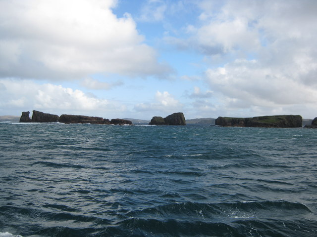
This headland is characterized by its towering cliffs, which rise dramatically from the sea. The cliffs are composed of rugged rock formations, showcasing various layers of sedimentary deposits, including sandstone and conglomerate. These formations offer a glimpse into the geological history of the region, with evidence of ancient landforms and geological processes.

Tarri Geo also serves as an important habitat for various seabird species, including puffins, guillemots, and fulmars. These birds nest on the cliff ledges, taking advantage of the inaccessible and protected environment. The surrounding waters are rich in marine life, attracting seals, dolphins, and occasionally even whales.

The headland offers breathtaking panoramic views of the North Sea, with its deep blue waters contrasting against the rugged landscape. Visitors to Tarri Geo can immerse themselves in the natural beauty of the area, exploring the coastal trails and cliff-top paths. The site is popular among hikers and nature enthusiasts who are drawn to its stunning vistas and abundant wildlife.

Overall, Tarri Geo is a remarkable coastal feature in Shetland, showcasing the power of nature and offering a unique glimpse into the geological and ecological diversity of the area.

If you have any feedback on the listing, please let us know in the comments section below.

Tarri Geo Images

Images are sourced within 2km of 60.341808/-1.7040247 or Grid Reference HU1662. Thanks to Geograph Open Source API. All images are credited.

Aesha Head One of the many fine stretches of coast on Papa Stours, Aesha Head is the furthest west point of the main island, though there are various smaller islands and skerries beyond.
Aesha Head
One of the many fine stretches of coast on Papa Stours, Aesha Head is the furthest west point of the main island, though there are various smaller islands and skerries beyond.
Natural Arch, Aesha Head This is a closer view of the fine arch in Aesha Head, with a glimpse of Lyra Skerry beyond.
Natural Arch, Aesha Head
This is a closer view of the fine arch in Aesha Head, with a glimpse of Lyra Skerry beyond.
Kirstan's Hole Actually, it isn't the Kirstan's Hole (or Christie's Hole) shown on the maps, but a second hole which opened suddenly a few years ago, where previously there had been a depression in the ground, into the same sea-cave system as the original Kirstan's Hole.
Kirstan's Hole
Actually, it isn't the Kirstan's Hole (or Christie's Hole) shown on the maps, but a second hole which opened suddenly a few years ago, where previously there had been a depression in the ground, into the same sea-cave system as the original Kirstan's Hole.
Storm Beach These boulders, thrown up by the waves to form a storm beach 30 metres above the sea, demonstrate the power of the seas which pound the exposed north side of Papa Stour
Storm Beach
These boulders, thrown up by the waves to form a storm beach 30 metres above the sea, demonstrate the power of the seas which pound the exposed north side of Papa Stour
Plantiecrub near Flaes Point A plantiecrub is a small walled enclosure in which cabbage seedlings are grown until they are big enough to plant out in croft gardens. They are usually built well away from the croft to protect the seedlings against the crofters' hens.
Plantiecrub near Flaes Point
A plantiecrub is a small walled enclosure in which cabbage seedlings are grown until they are big enough to plant out in croft gardens. They are usually built well away from the croft to protect the seedlings against the crofters' hens.
Ruined Meal Mills Several traditional mills straddle this little burn. Inside the building was a fixed lower millstone, and a rotating upper millstone driven by the water falling on to the paddles below, which were mounted at 45º to the vertical drive shaft.
Ruined Meal Mills
Several traditional mills straddle this little burn. Inside the building was a fixed lower millstone, and a rotating upper millstone driven by the water falling on to the paddles below, which were mounted at 45º to the vertical drive shaft.
The Loch that Ebbs and Flows The interior of Papa Stour is mainly moorland, though there are several lochans in the central part. This one's curious name reflects its closeness to the sea, from which it is cut off only by an ayre or shingle spit.
The Loch that Ebbs and Flows
The interior of Papa Stour is mainly moorland, though there are several lochans in the central part. This one's curious name reflects its closeness to the sea, from which it is cut off only by an ayre or shingle spit.
Lang Geo One of the many inlets typical of the north coast of Papa Stour.
Lang Geo
One of the many inlets typical of the north coast of Papa Stour.
Hurdibrack The last stretch of the footpath back from the west side of the island. In the middle distance is the wall which crosses the entire island, separating the arable land in the east from the pasture to the west.
Hurdibrack
The last stretch of the footpath back from the west side of the island. In the middle distance is the wall which crosses the entire island, separating the arable land in the east from the pasture to the west.
The Wall This is the wall which cuts across the whole island. The west side (left) has a steep face to prevent animals climbing over it. The east (right) side has a sloping face so that any animals which have managed to cross it can easily be driven back on to the pasture land.
The Wall
This is the wall which cuts across the whole island. The west side (left) has a steep face to prevent animals climbing over it. The east (right) side has a sloping face so that any animals which have managed to cross it can easily be driven back on to the pasture land.
Robie's Noust This is a very dull shot of a square which would certainly have yielded a more interesting image if we had had time to explore it before the ferry left.
Robie's Noust
This is a very dull shot of a square which would certainly have yielded a more interesting image if we had had time to explore it before the ferry left.
The Dales As with the next-door square, HU1861 would certainly have yielded a more interesting shot if we had not had to rush to catch the ferry!
The Dales
As with the next-door square, HU1861 would certainly have yielded a more interesting shot if we had not had to rush to catch the ferry!
Ruined House
Ruined House
Ruined house The number of ruined buildings on the island seem to far outnumber those still habitable or used.
Ruined house
The number of ruined buildings on the island seem to far outnumber those still habitable or used.
Road and ruins This is the main road for the island.  Even this close to the pier the ruins of abandoned crofts can be found just off the road.
Road and ruins
This is the main road for the island. Even this close to the pier the ruins of abandoned crofts can be found just off the road.
View towards Papa Stour Airstrip The cleared and smoothed ground in the upper right of the image is the airstrip for Papa Stour which is located in <a href="https://www.geograph.org.uk/gridref/HU1759">HU1759</a>.
View towards Papa Stour Airstrip
The cleared and smoothed ground in the upper right of the image is the airstrip for Papa Stour which is located in HU1759.
Remains of Observation Post The concrete and iron are the only remains of a World War Two observation post that used to stand here.  As can be seen from the image, in good visibility this location provides an excellent view of the surrounding area.
Remains of Observation Post
The concrete and iron are the only remains of a World War Two observation post that used to stand here. As can be seen from the image, in good visibility this location provides an excellent view of the surrounding area.
Rocky coastline
Rocky coastline
Show me another place!

Tarri Geo is located at Grid Ref: HU1662 (Lat: 60.341808, Lng: -1.7040247)

Unitary Authority: Shetland Islands

Police Authority: Highlands and Islands

What 3 Words

///grinders.trying.dreamer. Near Walls, Shetland Islands

Related Wikis

Papa Stour

Papa Stour is one of the Shetland Islands in Scotland, with a population of under fifteen people, some of whom immigrated after an appeal for residents...

Biggings

Biggings is a village on the island of Papa Stour, in Shetland, Scotland. Papa Stour's church is situated at the south of Biggings. A homestead of Duke...

Papa Stour Airstrip

Papa Stour Airstrip is a small airstrip in the village of Biggings on the island of Papa Stour. Shetland, Scotland. == History == Papa Stour Airstrip opened...

Maiden Stack

The Maiden Stack or Frau Stack is a tiny stack in the western Shetland Islands to the north of Brei Holm and east of Housa Voe about 140 metres (150 yd...

Have you been to Tarri Geo?

Leave your review of Tarri Geo below (or comments, questions and feedback).