Little Partons

Coastal Feature, Headland, Point in Aberdeenshire

Scotland

Little Partons

Guillemot Nap Time Guillemots taking a nap on the sheer cliffs of the Bullers of Buchan in Aberdeenshire.
Guillemot Nap Time Credit: Iain Smith

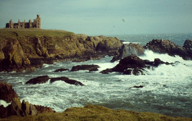
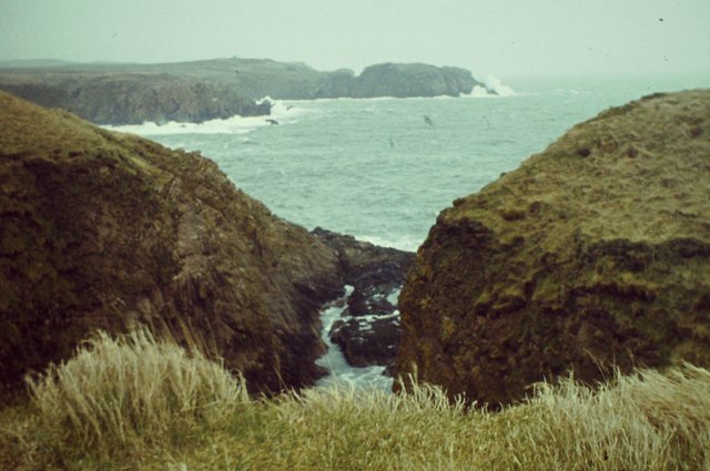
Little Partons is a picturesque coastal feature located in Aberdeenshire, Scotland. It is a headland that juts out into the North Sea, forming a prominent point along the coastline. The headland is characterized by its steep and rugged cliffs, which provide stunning panoramic views of the surrounding area.

The cliffs of Little Partons are composed of ancient rock formations, showcasing layers of sedimentary rocks that have been shaped by centuries of erosion from the crashing waves. The exposed rocks offer a glimpse into the geological history of the region, revealing evidence of past environments and ancient marine life.

The headland is also home to a diverse range of flora and fauna, making it a haven for nature enthusiasts. The surrounding coastal grasslands provide a habitat for various species of wildflowers, while the surrounding waters support a rich marine ecosystem. Visitors can often spot seabirds soaring overhead, including gannets, puffins, and kittiwakes.

Little Partons is a popular destination for outdoor activities such as hiking and birdwatching. There are several walking trails that lead visitors along the cliff tops, offering breathtaking views of the coastline and the North Sea. The headland is also a great spot for fishing, with anglers often casting their lines from the rocky shores.

Overall, Little Partons is a stunning coastal feature that combines natural beauty, geological significance, and abundant wildlife. Whether exploring the rugged cliffs, observing the diverse flora and fauna, or simply enjoying the awe-inspiring views, visitors to Little Partons are sure to be captivated by its natural splendor.

If you have any feedback on the listing, please let us know in the comments section below.

Little Partons Images

Images are sourced within 2km of 57.423496/-1.8235716 or Grid Reference NK1037. Thanks to Geograph Open Source API. All images are credited.

Guillemot Nap Time Guillemots taking a nap on the sheer cliffs of the Bullers of Buchan in Aberdeenshire.
Guillemot Nap Time
Guillemots taking a nap on the sheer cliffs of the Bullers of Buchan in Aberdeenshire.
Stormy Coast A rough day at New Slains Castle with big waves battering the rocky Buchan coast.
Stormy Coast
A rough day at New Slains Castle with big waves battering the rocky Buchan coast.
Long Haven Deep and extensive geo to the north of New Slains Castle.
Long Haven
Deep and extensive geo to the north of New Slains Castle.
The Pot Looking into The Pot, a collapsed sea cave at the Bullers of Buchan. The North Sea is visible through the arch.
<span class="nowrap"><a title="http://bullersofbuchan.me.uk/" rel="nofollow ugc noopener" href="http://bullersofbuchan.me.uk/">Link</a><img style="margin-left:2px;" alt="External link" title="External link - shift click to open in new window" src="https://s1.geograph.org.uk/img/external.png" width="10" height="10"/></span>
The Pot
Looking into The Pot, a collapsed sea cave at the Bullers of Buchan. The North Sea is visible through the arch. LinkExternal link
Bullers o' Buchan Famous collapsed sea cave on the Buchan coast south of Peterhead.
<span class="nowrap"><a title="http://bullersofbuchan.me.uk/" rel="nofollow ugc noopener" href="http://bullersofbuchan.me.uk/">Link</a><img style="margin-left:2px;" alt="External link" title="External link - shift click to open in new window" src="https://s1.geograph.org.uk/img/external.png" width="10" height="10"/></span>
Bullers o' Buchan
Famous collapsed sea cave on the Buchan coast south of Peterhead. LinkExternal link
Track to Slains Castle, Cruden Bay
Slains Castle from above Port Erroll harbour
Puffin at the Bullers of Buchan Sadly, there seems to be less puffins this year than usual on the cliffs at the Bullers of Buchan. Possibly due to the very extreme weather whilst they were at sea this season.
Puffin at the Bullers of Buchan
Sadly, there seems to be less puffins this year than usual on the cliffs at the Bullers of Buchan. Possibly due to the very extreme weather whilst they were at sea this season.
The cliffs just south of Bullers of Buchan
At Bullers of Buchan
Bullers of Buchan
Bullers of Buchan
An overbridge and the track bed formation of the Buchan Railway above North Haven
Natural arch at Bullers of Buchan
Bullers of Buchan
Bullers of Buchan
Mussel Craig
Mussel Craig
Cairn-na-hilt
Cairn-na-hilt
Bullers of Buchan Erosion of the cliff into a sea arch.
Bullers of Buchan
Erosion of the cliff into a sea arch.
Old Railway Embankment An embankment and single bridge stanchion, remaining from the former Great North of Scotland Railway as the line headed north.
Old Railway Embankment
An embankment and single bridge stanchion, remaining from the former Great North of Scotland Railway as the line headed north.
Show me another place!

Little Partons is located at Grid Ref: NK1037 (Lat: 57.423496, Lng: -1.8235716)

Unitary Authority: Aberdeenshire

Police Authority: North East

What 3 Words

///splints.winter.tensions. Near Port Erroll, Aberdeenshire

Related Wikis

Bullers O'Buchan Platform railway station

Bullers O'Buchan Platform railway station also known as Bullers O'Buchan Halt railway station was a railway station serving visitors to the Bullers of...
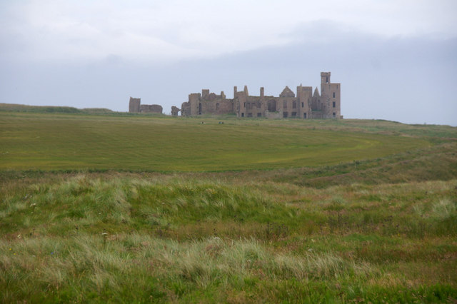
New Slains Castle

Slains Castle, also known as New Slains Castle to distinguish it from the nearby Old Slains Castle, is a ruined castle in Aberdeenshire, Scotland. It overlooks...

Bullers of Buchan

The name Bullers of Buchan refers both to a collapsed sea cave and to the adjacent village, situated about 6 miles (9.7 km) south of Peterhead in Buchan...

Water of Cruden

The Water of Cruden is a short broadly east-flowing river in Buchan in northeast Scotland. Its headwaters streams rise in the countryside north of Ellon...

Cruden Bay

Cruden Bay is a small village in Scotland, on the north coast of the Bay of Cruden in Aberdeenshire, 26 miles (42 km) north of Aberdeen. Just west of Slains...

Cruden Bay railway station

Cruden Bay railway station was a railway station serving Cruden Bay, Aberdeenshire, Scotland. == History == The station opened on 2 August 1897.The station...

A90 road

The A90 road is a major north to south road in eastern Scotland, running from Edinburgh to Fraserburgh, through Dundee and Aberdeen. Along with the A9...

Cruden Bay Hotel Tramway

The Cruden Bay Hotel Tramway operated an electric tramway service between the Cruden Bay Hotel and Cruden Bay railway station between 1899 and 1940....

Nearby Amenities

Located within 500m of 57.423496,-1.8235716
Source: OS7
Lat/Long: 57.4265659/-1.8175588
Source: OS7
Lat/Long: 57.4263831/-1.8179081
Source: OS7
Lat/Long: 57.4255123/-1.8193157
Source: OS7
Lat/Long: 57.4248411/-1.8185797
Source: OS7
Lat/Long: 57.424785/-1.8179585
Source: OS7
Lat/Long: 57.424521/-1.8170143
Source: OS7
Lat/Long: 57.424225/-1.8173968
Source: OS7
Lat/Long: 57.4243082/-1.8176463
Source: OS7
Lat/Long: 57.4243719/-1.819165
Source: OS7
Lat/Long: 57.4249168/-1.8192861
Source: OS7
Lat/Long: 57.4249043/-1.8202303
Source: OS7
Lat/Long: 57.4254401/-1.8211235
Source: OS7
Lat/Long: 57.4249032/-1.8212565
Source: OS7
Lat/Long: 57.4243162/-1.822041
Source: OS7
Lat/Long: 57.4241915/-1.8222221
Source: OS7
Lat/Long: 57.4235621/-1.8230429
Source: OS7
Lat/Long: 57.4232366/-1.8238314
Source: OS7
Lat/Long: 57.423034/-1.8235782
Source: OS7
Lat/Long: 57.4220176/-1.8247069
Source: OS7
Lat/Long: 57.4215537/-1.8270351
Source: OS7
Lat/Long: 57.4213011/-1.8277432
Source: OS7
Lat/Long: 57.4203418/-1.8279177
Source: OS7
Lat/Long: 57.4198849/-1.8284321
Source: OS7
Lat/Long: 57.4252831/-1.8207531
Source: OS7
Lat/Long: 57.4257185/-1.8214765
Source: OS7
Lat/Long: 57.4257861/-1.8218466
Source: OS7
Lat/Long: 57.4259178/-1.8218305
Source: OS7
Lat/Long: 57.4260875/-1.821573
Source: OS7
Lat/Long: 57.426008/-1.8202909
Source: OS7
Lat/Long: 57.4261124/-1.819556
Source: OS7
Lat/Long: 57.4262967/-1.8183233
Source: OS7
Lat/Long: 57.4258487/-1.8203096
Source: OS7
Lat/Long: 57.4257982/-1.8208971
Source: OS7
Lat/Long: 57.4255319/-1.8208435
The Kaim
Natural: cape
Lat/Long: 57.4213986/-1.826552
Bowfarts
Natural: cape
Lat/Long: 57.4221194/-1.8244689
Meikle Partans
Natural: cape
Lat/Long: 57.4229642/-1.8229365
Clubbs Chair
Natural: cape
Lat/Long: 57.4209274/-1.827509
Coral
Natural: cape
Lat/Long: 57.420379/-1.8278416
Twa Havens
Natural: bay
Lat/Long: 57.4212207/-1.8269434
Power: pole
Lat/Long: 57.4263441/-1.8296397
The data included in this document is from www.openstreetmap.org. The data is made available under ODbL.

Have you been to Little Partons?

Leave your review of Little Partons below (or comments, questions and feedback).