Dunbuy

Island in Aberdeenshire

Scotland

Dunbuy

Guillemot Nap Time Guillemots taking a nap on the sheer cliffs of the Bullers of Buchan in Aberdeenshire.
Guillemot Nap Time Credit: Iain Smith

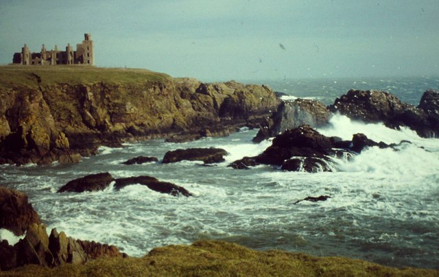
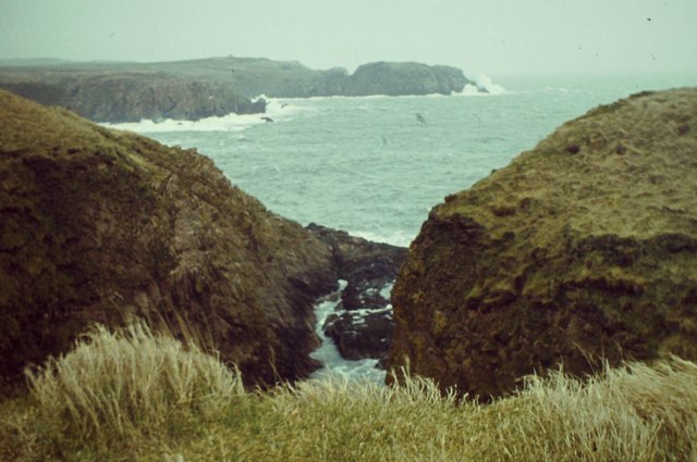
Dunbuy is a small island located off the coast of Aberdeenshire in Scotland. It is situated in the North Sea, approximately 2.5 miles northeast of the town of Stonehaven. The island spans an area of about 2.5 acres and is characterized by its rugged coastline and rocky terrain.

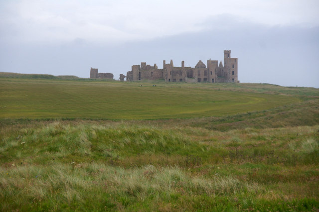
Dunbuy is primarily known for its historical significance. The island is home to the ruins of Dunbuy Castle, a medieval fortress that was built in the 13th century. The castle served as a defensive stronghold during various conflicts in Scottish history, including the Wars of Independence. Today, only the remains of the castle's walls and towers can be seen, but it still attracts visitors who are interested in exploring its history.

The island is also a popular spot for birdwatching enthusiasts. Its location along the coast makes it a haven for various seabird species, including gulls, puffins, and cormorants. Birdwatchers can often spot these creatures nesting and feeding along the cliffs and shorelines of Dunbuy.

Access to Dunbuy is mainly by boat or kayak, as there are no bridges or ferries connecting it to the mainland. Due to its small size and lack of amenities, the island is generally not inhabited, making it a peaceful and tranquil destination for those seeking solitude or a quiet retreat.

Overall, Dunbuy is a historical and natural gem of Aberdeenshire, offering visitors the opportunity to step back in time and appreciate Scotland's rich heritage and stunning coastal landscapes.

If you have any feedback on the listing, please let us know in the comments section below.

Dunbuy Images

Images are sourced within 2km of 57.425062/-1.8193846 or Grid Reference NK1037. Thanks to Geograph Open Source API. All images are credited.

Guillemot Nap Time Guillemots taking a nap on the sheer cliffs of the Bullers of Buchan in Aberdeenshire.
Guillemot Nap Time
Guillemots taking a nap on the sheer cliffs of the Bullers of Buchan in Aberdeenshire.
Stormy Coast A rough day at New Slains Castle with big waves battering the rocky Buchan coast.
Stormy Coast
A rough day at New Slains Castle with big waves battering the rocky Buchan coast.
Long Haven Deep and extensive geo to the north of New Slains Castle.
Long Haven
Deep and extensive geo to the north of New Slains Castle.
The Pot Looking into The Pot, a collapsed sea cave at the Bullers of Buchan. The North Sea is visible through the arch.
<span class="nowrap"><a title="http://bullersofbuchan.me.uk/" rel="nofollow ugc noopener" href="http://bullersofbuchan.me.uk/">Link</a><img style="margin-left:2px;" alt="External link" title="External link - shift click to open in new window" src="https://s1.geograph.org.uk/img/external.png" width="10" height="10"/></span>
The Pot
Looking into The Pot, a collapsed sea cave at the Bullers of Buchan. The North Sea is visible through the arch. LinkExternal link
Bullers o' Buchan Famous collapsed sea cave on the Buchan coast south of Peterhead.
<span class="nowrap"><a title="http://bullersofbuchan.me.uk/" rel="nofollow ugc noopener" href="http://bullersofbuchan.me.uk/">Link</a><img style="margin-left:2px;" alt="External link" title="External link - shift click to open in new window" src="https://s1.geograph.org.uk/img/external.png" width="10" height="10"/></span>
Bullers o' Buchan
Famous collapsed sea cave on the Buchan coast south of Peterhead. LinkExternal link
Track to Slains Castle, Cruden Bay
Slains Castle from above Port Erroll harbour
Puffin at the Bullers of Buchan Sadly, there seems to be less puffins this year than usual on the cliffs at the Bullers of Buchan. Possibly due to the very extreme weather whilst they were at sea this season.
Puffin at the Bullers of Buchan
Sadly, there seems to be less puffins this year than usual on the cliffs at the Bullers of Buchan. Possibly due to the very extreme weather whilst they were at sea this season.
The cliffs just south of Bullers of Buchan
At Bullers of Buchan
Bullers of Buchan
Bullers of Buchan
An overbridge and the track bed formation of the Buchan Railway above North Haven
Natural arch at Bullers of Buchan
Bullers of Buchan
Bullers of Buchan
Mussel Craig
Mussel Craig
Cairn-na-hilt
Cairn-na-hilt
Bullers of Buchan Erosion of the cliff into a sea arch.
Bullers of Buchan
Erosion of the cliff into a sea arch.
Old Railway Embankment An embankment and single bridge stanchion, remaining from the former Great North of Scotland Railway as the line headed north.
Old Railway Embankment
An embankment and single bridge stanchion, remaining from the former Great North of Scotland Railway as the line headed north.
Show me another place!

Dunbuy is located at Grid Ref: NK1037 (Lat: 57.425062, Lng: -1.8193846)

Unitary Authority: Aberdeenshire

Police Authority: North East

What 3 Words

///selects.transfers.minimums. Near Port Erroll, Aberdeenshire

Related Wikis

Bullers O'Buchan Platform railway station

Bullers O'Buchan Platform railway station also known as Bullers O'Buchan Halt railway station was a railway station serving visitors to the Bullers of...

Bullers of Buchan

The name Bullers of Buchan refers both to a collapsed sea cave and to the adjacent village, situated about 6 miles (9.7 km) south of Peterhead in Buchan...

New Slains Castle

Slains Castle, also known as New Slains Castle to distinguish it from the nearby Old Slains Castle, is a ruined castle in Aberdeenshire, Scotland. It overlooks...

Cruden Bay

Cruden Bay is a small village in Scotland, on the north coast of the Bay of Cruden in Aberdeenshire, 26 miles (42 km) north of Aberdeen. Just west of Slains...

Water of Cruden

The Water of Cruden is a short broadly east-flowing river in Buchan in northeast Scotland. Its headwaters streams rise in the countryside north of Ellon...

A90 road

The A90 road is a major north to south road in eastern Scotland, running from Edinburgh to Fraserburgh, through Dundee and Aberdeen. Along with the A9...

Cruden Bay railway station

Cruden Bay railway station was a railway station serving Cruden Bay, Aberdeenshire, Scotland. == History == The station opened on 2 August 1897.The station...

Cruden Bay Hotel Tramway

The Cruden Bay Hotel Tramway operated an electric tramway service between the Cruden Bay Hotel and Cruden Bay railway station between 1899 and 1940....

Nearby Amenities

Located within 500m of 57.425062,-1.8193846
Source: Old Landsat image trace
Lat/Long: 57.4292327/-1.816594
Source: Old Landsat image trace
Lat/Long: 57.4286626/-1.8164135
Source: OS7
Lat/Long: 57.4278889/-1.818401
Source: OS7
Lat/Long: 57.4265659/-1.8175588
Source: OS7
Lat/Long: 57.4263831/-1.8179081
Source: OS7
Lat/Long: 57.4255123/-1.8193157
Source: OS7
Lat/Long: 57.4248411/-1.8185797
Source: OS7
Lat/Long: 57.424785/-1.8179585
Source: OS7
Lat/Long: 57.424521/-1.8170143
Source: OS7
Lat/Long: 57.424225/-1.8173968
Source: OS7
Lat/Long: 57.4243082/-1.8176463
Source: OS7
Lat/Long: 57.4243719/-1.819165
Source: OS7
Lat/Long: 57.4249168/-1.8192861
Source: OS7
Lat/Long: 57.4249043/-1.8202303
Source: OS7
Lat/Long: 57.4254401/-1.8211235
Source: OS7
Lat/Long: 57.4249032/-1.8212565
Source: OS7
Lat/Long: 57.4243162/-1.822041
Source: OS7
Lat/Long: 57.4241915/-1.8222221
Source: OS7
Lat/Long: 57.4235621/-1.8230429
Source: OS7
Lat/Long: 57.4232366/-1.8238314
Source: OS7
Lat/Long: 57.423034/-1.8235782
Source: OS7
Lat/Long: 57.4220176/-1.8247069
Source: OS7
Lat/Long: 57.4252831/-1.8207531
Source: OS7
Lat/Long: 57.4257185/-1.8214765
Source: OS7
Lat/Long: 57.4257861/-1.8218466
Source: OS7
Lat/Long: 57.4259178/-1.8218305
Source: OS7
Lat/Long: 57.4260875/-1.821573
Source: OS7
Lat/Long: 57.426008/-1.8202909
Source: OS7
Lat/Long: 57.4261124/-1.819556
Source: OS7
Lat/Long: 57.4262967/-1.8183233
Source: OS7
Lat/Long: 57.4258487/-1.8203096
Source: OS7
Lat/Long: 57.4257982/-1.8208971
Source: OS7
Lat/Long: 57.4255319/-1.8208435
Source: OS7
Lat/Long: 57.4269559/-1.8174786
Source: OS7
Lat/Long: 57.4269979/-1.8160946
Source: OS7
Lat/Long: 57.4278251/-1.8154227
Source: Old Landsat image trace
Lat/Long: 57.4284802/-1.8161921
Bowfarts
Natural: cape
Lat/Long: 57.4221194/-1.8244689
Gray Mare
Natural: cape
Lat/Long: 57.4275466/-1.8152359
Meikle Partans
Natural: cape
Lat/Long: 57.4229642/-1.8229365
Lammylair
Natural: bay
Lat/Long: 57.4280527/-1.816484
The data included in this document is from www.openstreetmap.org. The data is made available under ODbL.

Have you been to Dunbuy?

Leave your review of Dunbuy below (or comments, questions and feedback).