Aver Hill

Coastal Feature, Headland, Point in Aberdeenshire

Scotland

Aver Hill

Old Slains Castle
Old Slains Castle Credit: Alan Reid

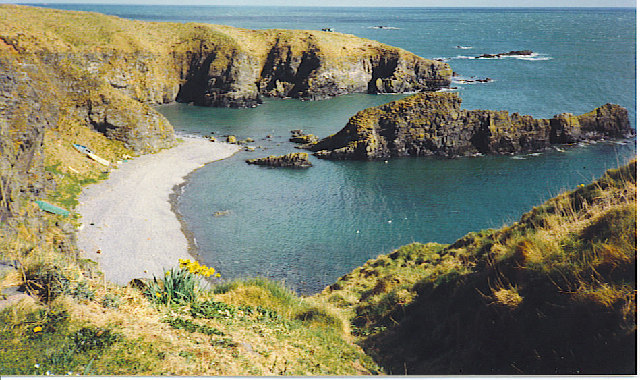
Aver Hill is a prominent coastal feature located in Aberdeenshire, Scotland. This headland, also referred to as Aver Point, is situated on the eastern coast of Scotland and offers stunning views of the North Sea. With its rugged cliffs and rocky terrain, Aver Hill stands as a majestic landmark in the area.

The headland is known for its picturesque beauty and is a popular destination for nature enthusiasts and hikers. The rugged coastal path that winds around Aver Hill provides visitors with an opportunity to explore the stunning surroundings and take in the breathtaking panoramic views of the sea and coastline.

Aver Hill is home to a diverse range of flora and fauna, making it an important ecological site. The cliffs and rock formations are inhabited by various seabirds, including kittiwakes, fulmars, and gannets, which nest in the crevices. The area is also known for its rich marine life, with seals often spotted basking on the rocks or swimming in the nearby waters.

The headland offers a sense of tranquility and seclusion, allowing visitors to escape the hustle and bustle of daily life and immerse themselves in nature. The crashing waves against the cliffs create a soothing soundtrack, while the fresh sea breeze invigorates the senses.

Aver Hill is easily accessible, with a car park located nearby for convenience. The area is well-maintained and offers paths and trails suitable for all levels of fitness. Whether it's a leisurely stroll along the coastline or a more challenging hike, Aver Hill provides a memorable experience for all who visit.

If you have any feedback on the listing, please let us know in the comments section below.

Aver Hill Images

Images are sourced within 2km of 57.350414/-1.9237764 or Grid Reference NK0428. Thanks to Geograph Open Source API. All images are credited.

Old Slains Castle
Old Slains Castle
Broad Haven Looking north-east up the coastline to Broad Haven.
Broad Haven
Looking north-east up the coastline to Broad Haven.
Mains of Slains Mains of Slains viewed from the road to the north.
Mains of Slains
Mains of Slains viewed from the road to the north.
Barley near the A975 Billowing barley field next to the A975 near Slains School.
Barley near the A975
Billowing barley field next to the A975 near Slains School.
Slains: all is safely gathered in All is safely gathered in as the first of the Winter storms develops over the Buchan countryside.
Slains: all is safely gathered in
All is safely gathered in as the first of the Winter storms develops over the Buchan countryside.
Slains Kirk, Collieston
Creels Fishing paraphernalia on the beach at Collieston.
Creels
Fishing paraphernalia on the beach at Collieston.
Former fishermans' cottages, Collieston
Road out of the village
The Old Manse, Collieston
The big rock behind the car park, Collieston
Rocky coast, Collieston Unforgiving rocks stretch for several kilometres either side of the narrow entrance to Collieston harbour.
Rocky coast, Collieston
Unforgiving rocks stretch for several kilometres either side of the narrow entrance to Collieston harbour.
Harbour views, Collieston
Collieston: walrus This walrus was photographed on the rocks in Collieston, in 1954, by the late Dr Bruce Forman. It was the first UK record in 100 years.
Collieston: walrus
This walrus was photographed on the rocks in Collieston, in 1954, by the late Dr Bruce Forman. It was the first UK record in 100 years.
Old winch at Collieston Harbour Boats at Collieston are pulled up on the hill, well above the high water mark. Other fishing paraphernalia, including this winch, creels and float, are also stored ere.
Old winch at Collieston Harbour
Boats at Collieston are pulled up on the hill, well above the high water mark. Other fishing paraphernalia, including this winch, creels and float, are also stored ere.
Entrance to Collieston Harbour Viewed from the southern side of the harbour.
Entrance to Collieston Harbour
Viewed from the southern side of the harbour.
Field of rape near Kirktown of Slains A large field of oilseed rape to the north-west of the minor road between Kirktown and Whinnyfold.
Field of rape near Kirktown of Slains
A large field of oilseed rape to the north-west of the minor road between Kirktown and Whinnyfold.
Collieston on a sunny day Collieston from the Kirkton of Slains headland.
Collieston on a sunny day
Collieston from the Kirkton of Slains headland.
Show me another place!

Aver Hill is located at Grid Ref: NK0428 (Lat: 57.350414, Lng: -1.9237764)

Unitary Authority: Aberdeenshire

Police Authority: North East

What 3 Words

///painted.newer.mopped. Near Newburgh, Aberdeenshire

Related Wikis

Collieston

Collieston is a small former fishing village on the North Sea coast in Aberdeenshire, Scotland. The village lies just north of the Sands of Forvie Special...

Old Slains Castle

Slains Castle (otherwise known as Old Slains Castle) is a ruined castle near Collieston in Aberdeenshire, Scotland. It is not to be confused with New Slains...

Cotehill Loch

Cotehill Loch is a freshwater loch located in Scotland in the Aberdeenshire area, approximately one mile (1.5 km) northwest of the coastal town of Collieston...

Ythan Estuary

The Ythan Estuary (Scottish Gaelic: Inbhir Eithein) is the tidal component of the Ythan River, emptying into the North Sea 19 kilometres (12 mi) north...

Meikle Loch

Meikle Loch is an inland loch some miles north of Collieston, Aberdeenshire, Scotland. It is designated as part of the Ythan Estuary complex, along with...

Hackley Head

Hackley Head (otherwise Forvie Ness) is a headland in Aberdeenshire, northeast Scotland. Hackley Head is located to the south of Hackley Bay and to the...

Forvie

Forvie was a village in what is now the Forvie National Nature Reserve, located at the modern location of Rockend some fourteen miles north of Aberdeen...

Whinnyfold

Whinnyfold or Whinneyfold is a small coastal village at the southern end of the Bay of Cruden in Aberdeenshire, Scotland. Whinnyfold (locally pronounced...

Nearby Amenities

Located within 500m of 57.350414,-1.9237764
Source: Old Landsat image trace
Lat/Long: 57.3543544/-1.9226752
Source: Old Landsat image trace
Lat/Long: 57.3540513/-1.9226114
Source: Old Landsat image trace
Lat/Long: 57.3537536/-1.9215948
Source: Old Landsat image trace
Lat/Long: 57.3533169/-1.9212749
Source: Old Landsat image trace
Lat/Long: 57.3531544/-1.9214517
Source: Old Landsat image trace
Lat/Long: 57.3526548/-1.9222717
Source: Old Landsat image trace
Lat/Long: 57.3530141/-1.9229266
Source: Old Landsat image trace
Lat/Long: 57.3527476/-1.923557
Source: Old Landsat image trace
Lat/Long: 57.3524596/-1.9240408
Source: Old Landsat image trace
Lat/Long: 57.3508131/-1.9248192
Source: Old Landsat image trace
Lat/Long: 57.3507468/-1.9240811
Source: Old Landsat image trace
Lat/Long: 57.3507807/-1.9235908
Source: Old Landsat image trace
Lat/Long: 57.3505892/-1.922568
Source: Old Landsat image trace
Lat/Long: 57.3503664/-1.9227572
Source: Old Landsat image trace
Lat/Long: 57.3499005/-1.9233873
Source: Old Landsat image trace
Lat/Long: 57.3498101/-1.9254307
Source: Old Landsat image trace
Lat/Long: 57.3500279/-1.9264024
Source: Old Landsat image trace
Lat/Long: 57.3494481/-1.9265325
Source: Old Landsat image trace
Lat/Long: 57.3499716/-1.9275074
Recycling
Recycling Type: container
Lat/Long: 57.3488466/-1.9311936
Source: Old Landsat image trace
Lat/Long: 57.3508783/-1.9229721
The data included in this document is from www.openstreetmap.org. The data is made available under ODbL.

Have you been to Aver Hill?

Leave your review of Aver Hill below (or comments, questions and feedback).