Brotherston's Hole

Coastal Feature, Headland, Point in Northumberland

England

Brotherston's Hole

Two churches Berwick upon Tweed The two churches to the east side of the town centre that are within the town walls. Photograph actually taken from town walls.
Two churches Berwick upon Tweed Credit: Clive Nicholson

Brotherston's Hole is a distinctive coastal feature located in Northumberland, England. It is situated on a headland, jutting out into the North Sea, and is known for its rugged beauty and dramatic cliffs. The hole itself is a deep, narrow inlet that has been carved out by the relentless action of the waves over centuries.

The hole is named after the Brotherston family, who were local landowners in the area. It has become a popular destination for tourists and nature lovers, attracting visitors from near and far. The sheer cliffs surrounding the hole provide a breathtaking view of the sea below, and the crashing waves against the rocks create a mesmerizing spectacle.

The area around Brotherston's Hole is rich in wildlife, with various seabirds nesting on the cliffs. Visitors can often spot species such as puffins, guillemots, and razorbills. The surrounding waters are also home to a diverse range of marine life, including seals and dolphins, which can sometimes be seen swimming in the distance.

Access to Brotherston's Hole is relatively easy, with a footpath leading down to the inlet from the nearby coastal path. However, caution is advised as the cliffs can be unstable, and the area is exposed to strong winds and rough seas.

Overall, Brotherston's Hole is a beautiful and captivating coastal feature, offering visitors a glimpse into the raw power of nature. Whether it's for a leisurely stroll along the cliffs or an opportunity to observe the diverse wildlife, this Northumberland gem is sure to leave a lasting impression.

If you have any feedback on the listing, please let us know in the comments section below.

Brotherston's Hole Images

Images are sourced within 2km of 55.786107/-2.0009948 or Grid Reference NU0054. Thanks to Geograph Open Source API. All images are credited.

Two churches Berwick upon Tweed The two churches to the east side of the town centre that are within the town walls. Photograph actually taken from town walls.
Two churches Berwick upon Tweed
The two churches to the east side of the town centre that are within the town walls. Photograph actually taken from town walls.
Observation Tower I will have to pay this place a visit and try and give you some information
Observation Tower
I will have to pay this place a visit and try and give you some information
Barracks, Berwick. One of the many fine old buildings in the town, this is of great importance as the first ever purpose built barracks. A forerunner of the ruins at Ruthven and Bernera, dating to 1721. Now in the care of English Heritage.
Barracks, Berwick.
One of the many fine old buildings in the town, this is of great importance as the first ever purpose built barracks. A forerunner of the ruins at Ruthven and Bernera, dating to 1721. Now in the care of English Heritage.
Berwick town walls The east facing wall.
Berwick town walls
The east facing wall.
Walking the walls, Berwick The town walls make a good walk and the first thing I do when visiting a walled town is try and walk around them. The wall area is effectively a big park surrounding the town centre and is put to good use by the locals.
Walking the walls, Berwick
The town walls make a good walk and the first thing I do when visiting a walled town is try and walk around them. The wall area is effectively a big park surrounding the town centre and is put to good use by the locals.
The Ditches. Below the fortifications, a playground.
The Ditches.
Below the fortifications, a playground.
A townhouse, Berwick
Beach at Sharper's Head, North of Berwick Access down to the beach from the Caravan Park at Sharper's Head.
Beach at Sharper's Head, North of Berwick
Access down to the beach from the Caravan Park at Sharper's Head.
Beach at Sharper's Head, North of Berwick Access to the beach from the caravan park at Sharper's Head.
Beach at Sharper's Head, North of Berwick
Access to the beach from the caravan park at Sharper's Head.
Cliffs, Sharper's Head, North of Berwick Craggy cliffs with numerous caves north of Berwick-upon-Tweed. There is the remains of a building of some sort in the foreground.
Cliffs, Sharper's Head, North of Berwick
Craggy cliffs with numerous caves north of Berwick-upon-Tweed. There is the remains of a building of some sort in the foreground.
Cliffs from Berwickshire Coastal path Craggy cliffs and caves
Cliffs from Berwickshire Coastal path
Craggy cliffs and caves
Brotherston's Hole, North of Berwick-upon-Tweed
Beach at Sharper's Head, North of Berwick View towards Sharper's Head with the caravan park visible on the cliff top.
Beach at Sharper's Head, North of Berwick
View towards Sharper's Head with the caravan park visible on the cliff top.
Caves, near Shaper's Head There are a number of caves in the cliffs north of Berwick-upon-Tweed.
Caves, near Shaper's Head
There are a number of caves in the cliffs north of Berwick-upon-Tweed.
Oystercatchers on the Tee At Magdalene Fields Golf Course, Berwick-upon-Tweed.
Oystercatchers on the Tee
At Magdalene Fields Golf Course, Berwick-upon-Tweed.
The Beach at Sharper's Head, Berwick-upon-Tweed Just after high tide.
The Beach at Sharper's Head, Berwick-upon-Tweed
Just after high tide.
Caravan Park at Shaper's Head, Berwick-upon-Tweed
Barracks from the  ramparts Berwick Barracks were begun in 1717 and were among the first in England to be purpose-built.  They were designed by architect Nicholas Hawksmoor who was an assistant to Sir Christopher Wren.  He also worked for Sir John Vanbrugh on the construction of Castle Howard and on Blenheim Palace.
Barracks from the ramparts
Berwick Barracks were begun in 1717 and were among the first in England to be purpose-built. They were designed by architect Nicholas Hawksmoor who was an assistant to Sir Christopher Wren. He also worked for Sir John Vanbrugh on the construction of Castle Howard and on Blenheim Palace.
Show me another place!

Brotherston's Hole is located at Grid Ref: NU0054 (Lat: 55.786107, Lng: -2.0009948)

Unitary Authority: Northumberland

Police Authority: Northumbria

What 3 Words

///unable.trick.healers. Near Berwick-Upon-Tweed, Northumberland

Related Wikis

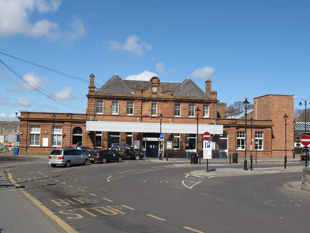
Berwick-upon-Tweed railway station

Berwick-upon-Tweed is a railway station on the East Coast Main Line, which runs between London King's Cross and Edinburgh Waverley. The station, situated...

Sack of Berwick (1296)

The sack of Berwick was the first significant battle of the First War of Scottish Independence in 1296. == Background == Upon the death of Margaret, Maid...

English invasion of Scotland (1482)

In July 1482 an English army invaded Scotland during the Anglo-Scottish Wars. The town of Berwick-upon-Tweed and its castle were captured and the English...
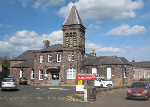
Berwick Infirmary

Berwick Infirmary is a community hospital in Berwick-upon-Tweed, Northumberland, England. It is managed by Northumbria Healthcare NHS Foundation Trust...

Nearby Amenities

Located within 500m of 55.786107,-2.0009948
Brotherston's Hole
Place: locality
Lat/Long: 55.7862711/-1.9994137
The data included in this document is from www.openstreetmap.org. The data is made available under ODbL.

Have you been to Brotherston's Hole?

Leave your review of Brotherston's Hole below (or comments, questions and feedback).