Crawpeel Shore

Coastal Feature, Headland, Point in Kincardineshire

Scotland

Crawpeel Shore

Quarry at Blackhills, south of Aberdeen, from the air Taken from a plane approaching Aberdeen Airport.
Quarry at Blackhills, south of Aberdeen, from the air Credit: Mike Pennington

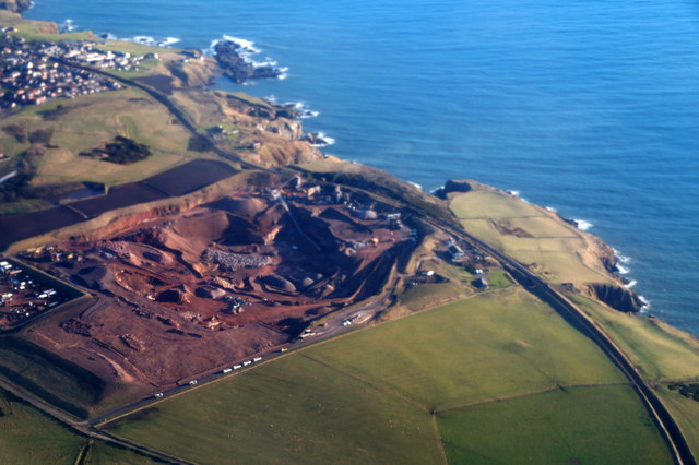
Crawpeel Shore is a prominent coastal feature located in Kincardineshire, Scotland. Situated on the east coast, it is a headland that extends into the North Sea, forming a distinctive point along the coastline.

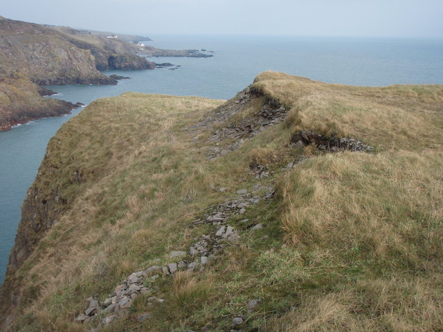
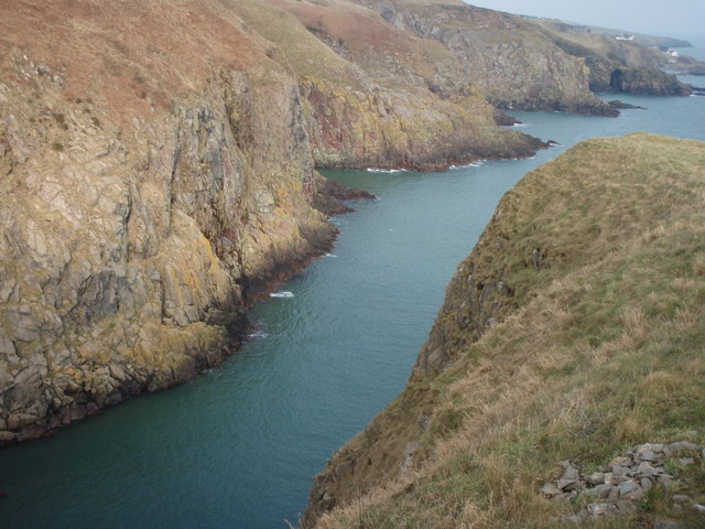
The shore is characterized by its rugged and picturesque landscape, with steep cliffs rising from the sea below. These cliffs are composed of various rock formations, including sandstone and shale, which have been shaped by the constant erosion caused by the crashing waves and strong currents.

Due to its exposed location, Crawpeel Shore experiences the full force of the North Sea, making it an ideal spot for observing the power and beauty of the ocean. The area is known for its dramatic scenery, with panoramic views of the sea and surrounding coastline.

The headland is also home to a diverse range of flora and fauna. The cliffs provide nesting grounds for numerous seabirds, including gannets, kittiwakes, and fulmars. The rock pools found at low tide are teeming with various marine life, such as crabs, starfish, and small fish.

Crawpeel Shore is a popular destination for nature enthusiasts, hikers, and photographers. Its remote location and untouched beauty make it an idyllic spot for coastal walks, birdwatching, and capturing stunning sunsets.

Overall, Crawpeel Shore is a captivating coastal feature in Kincardineshire, offering visitors a chance to immerse themselves in the raw and untamed beauty of Scotland's eastern coastline.

If you have any feedback on the listing, please let us know in the comments section below.

Crawpeel Shore Images

Images are sourced within 2km of 57.098015/-2.0723709 or Grid Reference NJ9500. Thanks to Geograph Open Source API. All images are credited.

Quarry at Blackhills, south of Aberdeen, from the air Taken from a plane approaching Aberdeen Airport.
Quarry at Blackhills, south of Aberdeen, from the air
Taken from a plane approaching Aberdeen Airport.
View into Clashrodney View into this deep inlet from the south slopes
View into Clashrodney
View into this deep inlet from the south slopes
Fields above cliffs near Hare Ness
Bales in a field
Bales in a field
Coastal pasture, Aberdeenshire
Blackhill Quarry Taken from the entrance gate looking into the quarry on the new entrance road.
Blackhill Quarry
Taken from the entrance gate looking into the quarry on the new entrance road.
Blackhill Quarry A view of the inside of Blackhill Quarry and the processing plant.
Blackhill Quarry
A view of the inside of Blackhill Quarry and the processing plant.
Hareness looking SW From the head, looking slightly SW. Taken at noon.
Hareness looking SW
From the head, looking slightly SW. Taken at noon.
Hareness looking West and down
Hareness looking NNW Looking NNW further out clockwise from <a title="https://www.geograph.org.uk/photo/696452" href="https://www.geograph.org.uk/photo/696452">Link</a>
Hareness looking NNW
Looking NNW further out clockwise from Link
Hareness NNW Looking NNW  along the coast.
Hareness NNW
Looking NNW along the coast.
Hareness looking W up
Hareness NNE down
Hareness NNE down
Hareness looking WSW
Hareness looking NNW down
Hareness looking south Something man-made but why, what?
Hareness looking south
Something man-made but why, what?
Hareness looking E down
Looking E towards Hareness Head From the inland side of the railway bridge.
Looking E towards Hareness Head
From the inland side of the railway bridge.
Show me another place!

Crawpeel Shore is located at Grid Ref: NJ9500 (Lat: 57.098015, Lng: -2.0723709)

Unitary Authority: City of Aberdeen

Police Authority: North East

What 3 Words

///cargo.wire.pipes. Near Cove, Aberdeen

Related Wikis

Nearby Amenities

Located within 500m of 57.098015,-2.0723709
Post Box
Collection Times: Mo-Fr 17:00; Sa 11:45
Post Box Type: pillar
Postal Code: AB12
Ref: AB12 454
Royal Cypher: GVIR
Royal Cypher Wikidata: Q33102169
Source: survey
Lat/Long: 57.0986882/-2.0797913
Shop: convenience
Lat/Long: 57.0986835/-2.0798579
Cove Bay
Historic Railway: station
Railway: site
Wikidata: Q55608504
Wikipedia: en:Cove Bay railway station
Lat/Long: 57.1001903/-2.0786913
Bus Stop
Colsea Road
Bench: yes
Bin: no
Bus: yes
Lit: yes
Naptan AtcoCode: 639002831
Naptan CommonName: Colsea Road
Naptan Indicator: adj
Naptan NaptanCode: 23232354
Naptan Verified: no
Public Transport: platform
Shelter: yes
Tactile Paving: no
Lat/Long: 57.098946/-2.0797173
Colour: green
Man Made: street_cabinet
Operator: Cityfibre
Street Cabinet: telecom
Telecom Medium: fibre
Lat/Long: 57.0996216/-2.0798156
Cove Bay Harbour
Leisure: marina
Seamark Harbour Category: marina
Seamark Type: harbour
Lat/Long: 57.0967499/-2.0749262
Generator Method: photovoltaic
Generator Output Electricity: yes
Generator Source: solar
Generator Type: solar_photovoltaic_panel
Power: generator
Lat/Long: 57.1014844/-2.0765307
Isie Caie
Artist Name: Albertino Costa
Artwork Type: statue
Tourism: artwork
Lat/Long: 57.0978844/-2.0792074
Generator Method: photovoltaic
Generator Output Electricity: yes
Generator Source: solar
Generator Type: solar_photovoltaic_panel
Location: roof
Power: generator
Lat/Long: 57.099728/-2.0793611
Grit Bin
Lat/Long: 57.0977374/-2.0794952
Grit Bin
Lat/Long: 57.0980489/-2.0737378
The data included in this document is from www.openstreetmap.org. The data is made available under ODbL.

Have you been to Crawpeel Shore?

Leave your review of Crawpeel Shore below (or comments, questions and feedback).