Craig Stirling

Coastal Feature, Headland, Point in Kincardineshire

Scotland

Craig Stirling

House and fields north of Newtonhill
House and fields north of Newtonhill Credit: Mike Pennington

Craig Stirling is a prominent coastal feature located in Kincardineshire, Scotland. It is widely known as a headland and point, offering stunning views of the North Sea.

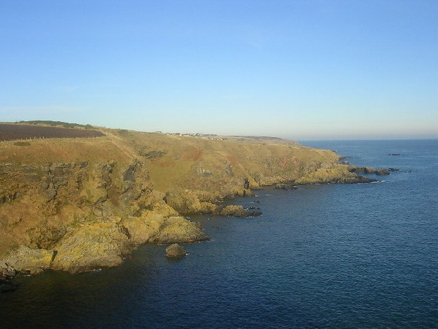
Situated on the east coast of Scotland, Craig Stirling is characterized by its rugged cliffs and rocky terrain. Rising steeply from the sea, it provides a dramatic backdrop to the surrounding landscape. The headland is composed of a mixture of sedimentary and igneous rocks, which have been shaped over time by the relentless forces of wind and water.

At the top of Craig Stirling, visitors can enjoy breathtaking vistas of the North Sea and the surrounding countryside. On a clear day, it is even possible to spot distant landmarks such as Dunnottar Castle and the picturesque town of Stonehaven. The headland is also home to a variety of wildlife, including seabirds and grazing sheep.

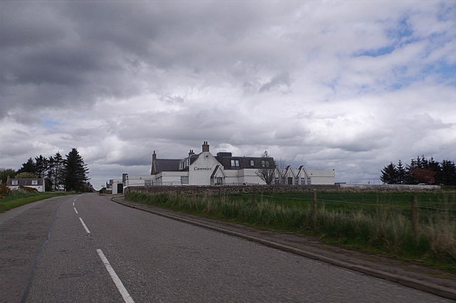
Access to Craig Stirling is relatively easy, with a well-maintained footpath leading from the nearby coastal village. The path offers a leisurely walk, allowing visitors to immerse themselves in the natural beauty of the area. However, caution is advised when exploring the headland, as the cliffs can be treacherous and require care.

Overall, Craig Stirling is a captivating coastal feature that attracts nature enthusiasts, hikers, and photographers alike. Its rugged beauty, panoramic views, and rich biodiversity make it a must-visit destination for those exploring the Kincardineshire coastline.

If you have any feedback on the listing, please let us know in the comments section below.

Craig Stirling Images

Images are sourced within 2km of 57.033842/-2.1339811 or Grid Reference NO9193. Thanks to Geograph Open Source API. All images are credited.

House and fields north of Newtonhill
Looking towards Cammachmore Bay Photographer is standing at the verge of the minor paved road.
Looking towards Cammachmore Bay
Photographer is standing at the verge of the minor paved road.
Cammies Inn, Cammachmore Near Newtonhill, on the former main road from Stonehaven to Aberdeen (now bypassed by A90 dual carriageway).
Cammies Inn, Cammachmore
Near Newtonhill, on the former main road from Stonehaven to Aberdeen (now bypassed by A90 dual carriageway).
Bend in road, Cammachmore village
Road into Cammachmore, near Newtonhill
Junction at Cammachmore, near Portleithen
Windyedge, Newtonhill
Site of Newtonhill Station The station closed in 1956 although there is some talk of reopening it as Newtonhill has transformed from a fishing village to a commuter settlement.  Compare the photo from 2009 <a title="https://www.geograph.org.uk/photo/1454732" href="https://www.geograph.org.uk/photo/1454732">Link</a> for changes to track layout and signals.
Site of Newtonhill Station
The station closed in 1956 although there is some talk of reopening it as Newtonhill has transformed from a fishing village to a commuter settlement. Compare the photo from 2009 Link for changes to track layout and signals.
High Speed Train The 14:52 from Aberdeen to King's Cross passes the site of Newtonhill station.
High Speed Train
The 14:52 from Aberdeen to King's Cross passes the site of Newtonhill station.
Newtonhill parish church This modest structure dates from 1987.
Newtonhill parish church
This modest structure dates from 1987.
Newtonhill: walking to the harbour The cat was friendly...
Newtonhill: walking to the harbour
The cat was friendly...
Newtonhill Bay
Newtonhill Bay
Walking the coastal path The rugged Cran Hill (elev. 86 m) is in the background: could it be called a tor?
Walking the coastal path
The rugged Cran Hill (elev. 86 m) is in the background: could it be called a tor?
The Newton Arms, Newtonhill
Houses at Newtonhill Viewed from the A92.
Houses at Newtonhill
Viewed from the A92.
Plaxton Elite Coach on the A92 at Newtonhill Park's of Hamilton Volvo B11R/Plaxton Elite (LSK 873) heading south on the A92 at Newtonhill.
Plaxton Elite Coach on the A92 at Newtonhill
Park's of Hamilton Volvo B11R/Plaxton Elite (LSK 873) heading south on the A92 at Newtonhill.
Bridge over the A92 at Newtonhill The A92 is a major highway that runs for 89 miles through Fife, Dundee, Angus, Aberdeenshire, and Aberdeen City in Scotland. From south to north, it runs from Dunfermline to Blackdog, just north of Aberdeen.
Bridge over the A92 at Newtonhill
The A92 is a major highway that runs for 89 miles through Fife, Dundee, Angus, Aberdeenshire, and Aberdeen City in Scotland. From south to north, it runs from Dunfermline to Blackdog, just north of Aberdeen.
Northbound A92 near to Cammachmore The A92 is a major highway that runs for 89 miles through Fife, Dundee, Angus, Aberdeenshire, and Aberdeen City in Scotland. From south to north, it runs from Dunfermline to Blackdog, just north of Aberdeen.
Northbound A92 near to Cammachmore
The A92 is a major highway that runs for 89 miles through Fife, Dundee, Angus, Aberdeenshire, and Aberdeen City in Scotland. From south to north, it runs from Dunfermline to Blackdog, just north of Aberdeen.
Show me another place!

Craig Stirling is located at Grid Ref: NO9193 (Lat: 57.033842, Lng: -2.1339811)

Unitary Authority: Aberdeenshire

Police Authority: North East

What 3 Words

///piled.proposes.paraded. Near Newtonhill, Aberdeenshire

Related Wikis

Burn of Elsick

The Burn of Elsick is a coastal stream in Aberdeenshire, Scotland that discharges to the North Sea. This watercourse drains primarily agricultural lands...

Newtonhill railway station

Newtonhill railway station served the town of Newtonhill in Aberdeenshire, Scotland, United Kingdom from its opening in 1851 to its closure in 1956. Newtonhill...

Newtonhill

Newtonhill is a commuter town in Kincardineshire, Scotland. It is popular due to its location, just six miles south of Aberdeen with easy reach of Stonehaven...

Downies

Downies is a cliff-top village in Aberdeenshire, Scotland situated on Cammachmore Bay. Historically Downies was a fishing village, until much of the local...

May Craig (island)

May Craig is a rocky island situated along the North Sea coast of Aberdeenshire, Scotland. May Craig lies about one half mile (0.8 km) south of Newtonhill...

Cammachmore Bay

Cammachmore Bay is an embayment of the North Sea between Stonehaven and Aberdeen in Aberdeenshire, Scotland. The fishing village of Downies is situated...

Cammachmore

Cammachmore (Gaelic An Camach Mòr) is a hamlet in the coastal region near the North Sea in Aberdeenshire. It lies slightly west of the A92 road and the...

Brown Jewel

The Brown Jewel is a sea stack on the North Sea coast of Scotland, north of the village of Muchalls in Aberdeenshire. == History == Brown Jewel is situated...

Nearby Amenities

Located within 500m of 57.033842,-2.1339811
Source: PGS
Lat/Long: 57.0326863/-2.1419141
Source: PGS
Lat/Long: 57.0323102/-2.1413758
Source: PGS
Lat/Long: 57.032211/-2.1402098
Source: PGS
Lat/Long: 57.0327007/-2.1395445
Source: PGS
Lat/Long: 57.032452/-2.138041
Source: PGS
Lat/Long: 57.032574/-2.137099
Source: PGS
Lat/Long: 57.032832/-2.137328
Source: PGS
Lat/Long: 57.033089/-2.137557
Source: PGS
Lat/Long: 57.03321/-2.136615
Source: PGS
Lat/Long: 57.03345/-2.134261
Source: PGS
Lat/Long: 57.033577/-2.134024
Source: PGS
Lat/Long: 57.033833/-2.134018
Source: PGS
Lat/Long: 57.0339378/-2.1338582
Source: PGS
Lat/Long: 57.034353/-2.135179
Source: PGS
Lat/Long: 57.0345084/-2.1345127
Source: PGS
Lat/Long: 57.0349063/-2.1342573
Source: PGS
Lat/Long: 57.0351369/-2.1337198
Source: PGS
Lat/Long: 57.035881/-2.13397
Source: PGS
Lat/Long: 57.036139/-2.134198
Source: PGS
Lat/Long: 57.0362741/-2.1314233
Source: PGS
Lat/Long: 57.036373/-2.131141
Source: PGS
Lat/Long: 57.036885/-2.131129
Source: PGS
Lat/Long: 57.0376678/-2.1316271
The data included in this document is from www.openstreetmap.org. The data is made available under ODbL.

Have you been to Craig Stirling?

Leave your review of Craig Stirling below (or comments, questions and feedback).