Douniefell
Coastal Feature, Headland, Point in Kincardineshire
Scotland
Douniefell

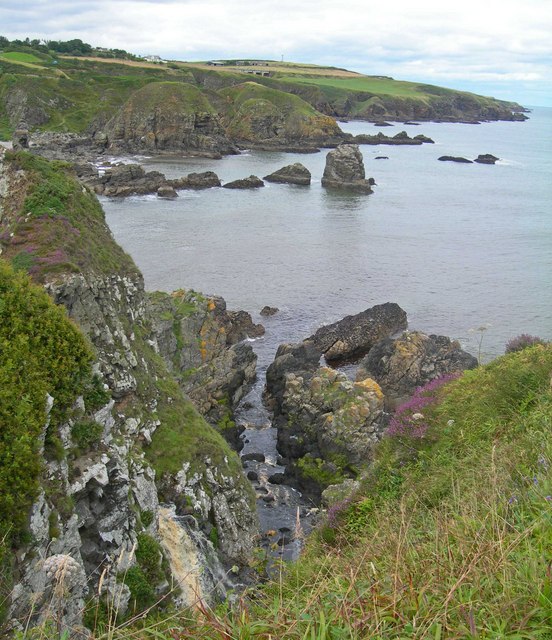
Douniefell is a prominent coastal feature located in the region of Kincardineshire, Scotland. It is an impressive headland that juts out into the North Sea, forming a distinctive point along the coastline. The name "Douniefell" is believed to originate from the Gaelic language, with "dounie" meaning "hill" and "fell" referring to a high, barren landscape.
This headland is characterized by its rugged terrain and steep cliffs that provide breathtaking views of the surrounding area. The cliffs are composed of sedimentary rock, showcasing layers of different geological formations, which are of great interest to geologists and nature enthusiasts alike. The headland is also home to a diverse array of flora and fauna, including various seabirds that nest along the cliffs.
The coastal feature of Douniefell offers visitors an opportunity to explore its rugged beauty and experience the power of the North Sea. Walking trails have been established along the headland, allowing hikers to enjoy the stunning coastal scenery and observe the abundant wildlife. Additionally, fishing is a popular activity in the surrounding waters, attracting anglers seeking a catch of sea trout or mackerel.
Douniefell is not only a natural attraction but also holds historical significance. The headland served as a lookout point during times of war and is believed to have played a role in coastal defense strategies. The remnants of old fortifications can still be seen, serving as a reminder of the region's rich history.
Overall, Douniefell is a captivating coastal feature, with its dramatic cliffs, diverse wildlife, and historical significance. It offers visitors a chance to immerse themselves in the natural beauty of the Scottish coastline and appreciate the historical heritage of the area.
If you have any feedback on the listing, please let us know in the comments section below.
Douniefell Images
Images are sourced within 2km of 57.015565/-2.1614495 or Grid Reference NO9091. Thanks to Geograph Open Source API. All images are credited.


Douniefell is located at Grid Ref: NO9091 (Lat: 57.015565, Lng: -2.1614495)
Unitary Authority: Aberdeenshire
Police Authority: North East
What 3 Words
///backed.says.kidney. Near Newtonhill, Aberdeenshire
Nearby Locations
Related Wikis
Grim Brigs
Grim Brigs (Grid reference NO9091) is a rocky headland on the North Sea at Muchalls, Scotland. Notable historic features in this vicinity include St....

Muchalls railway station
Muchalls railway station served the village of Muchalls, Kincardineshire, Scotland from 1849 to 1950 on the Aberdeen Railway. == History == The station...
Burn of Muchalls
The Burn of Muchalls is an easterly flowing stream in Aberdeenshire, Scotland that discharges to the North Sea. Its point of discharge is on a rocky beach...
Burn of Monboys
Burn of Monboys is a stream that rises in the Mounth, or eastern range of the Grampian Mountains, northwest of Stonehaven and south of Netherley, Aberdeenshire...
Nearby Amenities
Located within 500m of 57.015565,-2.1614495Have you been to Douniefell?
Leave your review of Douniefell below (or comments, questions and feedback).