Bottle Craig

Coastal Feature, Headland, Point in Kincardineshire

Scotland

Bottle Craig

Coast of pebbles south of Gourdon Looking up the coast towards Gourdon and Bervie Brow in the distance.
Coast of pebbles south of Gourdon Credit: Scott Cormie

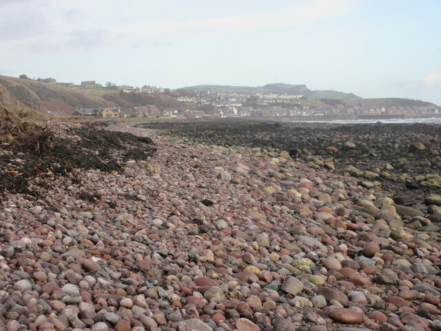
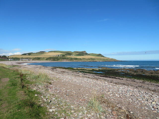
Bottle Craig is a prominent coastal feature located in Kincardineshire, Scotland. It is a striking headland that juts out into the North Sea, forming a distinctive point along the coastline. The name "Bottle Craig" is derived from its unique shape, which resembles an inverted bottle.

This headland is composed of rugged cliffs that rise steeply from the sea, providing a dramatic backdrop to the surrounding landscape. The cliffs are made up of sedimentary rock, showcasing layers of different geological formations, which are of great interest to geologists and nature enthusiasts alike.

Bottle Craig is known for its stunning natural beauty and is a popular destination for outdoor enthusiasts. The headland offers breathtaking panoramic views of the North Sea and the surrounding coastline, making it an ideal spot for photographers and nature lovers to capture the beauty of the Scottish coastline.

The area around Bottle Craig is also home to a diverse range of marine and birdlife. Seals can often be spotted basking on the rocks, while seabirds such as gulls, fulmars, and cormorants can be seen nesting on the cliffs.

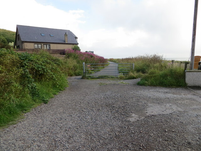
Access to Bottle Craig is relatively easy, with a well-maintained coastal path leading visitors to the headland. The path offers opportunities for leisurely walks, allowing visitors to explore the surrounding area and soak in the stunning coastal scenery.

In conclusion, Bottle Craig is a captivating coastal feature in Kincardineshire, Scotland, renowned for its distinctive shape, rugged cliffs, and breathtaking views. It is a must-visit destination for those seeking to experience the natural beauty of the Scottish coastline.

If you have any feedback on the listing, please let us know in the comments section below.

Bottle Craig Images

Images are sourced within 2km of 56.834044/-2.2760063 or Grid Reference NO8371. Thanks to Geograph Open Source API. All images are credited.

Coast of pebbles south of Gourdon Looking up the coast towards Gourdon and Bervie Brow in the distance.
Coast of pebbles south of Gourdon
Looking up the coast towards Gourdon and Bervie Brow in the distance.
Couts Rocks This superficially dull-looking rocky shore was full of interest. The variety of pebbles on the beach was astonishing, and the rocky pools were alive with wading birds. The rocks are Old Red Sandstone conglomerates.
Couts Rocks
This superficially dull-looking rocky shore was full of interest. The variety of pebbles on the beach was astonishing, and the rocky pools were alive with wading birds. The rocks are Old Red Sandstone conglomerates.
The shoreline south of Gourdon
Coastline South of Gourdon From the footpath to the Haughs of Benholm the coastline South of Gourdon
Coastline South of Gourdon
From the footpath to the Haughs of Benholm the coastline South of Gourdon
Coast path Appears to be a raised beach with a steep slope a little inland, enough for an arable field.
Coast path
Appears to be a raised beach with a steep slope a little inland, enough for an arable field.
Offshore Rocks Nearly submerged rocks off the stony foreshore.
Offshore Rocks
Nearly submerged rocks off the stony foreshore.
Coutts Rock An outcrop of rock to the south of Gourdon.
Coutts Rock
An outcrop of rock to the south of Gourdon.
Rocky shore at Couts Rocks With a small platoon of cormorants.
Rocky shore at Couts Rocks
With a small platoon of cormorants.
Shingle beach and rocky shore Just south of Gourdon village.
Shingle beach and rocky shore
Just south of Gourdon village.
Minor road at Dendoldrum Farm Looking south-westward.
Minor road at Dendoldrum Farm
Looking south-westward.
Church Street, Inverbervie Looking north-westward from beside Bervie School.
Church Street, Inverbervie
Looking north-westward from beside Bervie School.
Kirk Burn, Inverbervie Looking south-eastward from near to the Fire Station.
Kirk Burn, Inverbervie
Looking south-eastward from near to the Fire Station.
A part of Gourdon Cemetery Looking westward towards private housing on Brae Road.
A part of Gourdon Cemetery
Looking westward towards private housing on Brae Road.
Gourdon Harbour Looking north-westward.
Gourdon Harbour
Looking north-westward.
Recreational Trail converted from a disused railway line at Gourdon Looking north-eastward.
Recreational Trail converted from a disused railway line at Gourdon
Looking north-eastward.
Recreational Trail converted from a disused railway line beside Horse Crook Bay, Gourdon Looking north-eastward.
Recreational Trail converted from a disused railway line beside Horse Crook Bay, Gourdon
Looking north-eastward.
Flowering boat Inverbervie An old boat finds a new use on the green above the beach at Inverbervie.
Flowering boat Inverbervie
An old boat finds a new use on the green above the beach at Inverbervie.
Beach at Inverbervie Pebble beach with rocky reefs along the shoreline.
Beach at Inverbervie
Pebble beach with rocky reefs along the shoreline.
Show me another place!

Bottle Craig is located at Grid Ref: NO8371 (Lat: 56.834044, Lng: -2.2760063)

Unitary Authority: Aberdeenshire

Police Authority: North East

What 3 Words

///dolly.aviation.lame. Near Inverbervie, Aberdeenshire

Related Wikis

Gourdon railway station (NBR)

Gourdon railway station served the village of Gourdon, Aberdeenshire, Scotland from 1865 to 1951 on the Montrose and Bervie Railway. == History == The...

Gourdon, Aberdeenshire

Gourdon () nicknamed Gurdin by the population, is a coastal fishing village in Aberdeenshire, Scotland, south of Inverbervie and north of Johnshaven, with...

Inverbervie railway station

Bervie railway station served the town of Inverbervie, Aberdeenshire, Scotland from 1865 to 1966 on the Montrose and Bervie Railway. == History == The...

Inverbervie

Inverbervie (from Scottish Gaelic: Inbhir Biorbhaidh or Biorbhaigh, "mouth of the River Bervie") is a small town on the north-east coast of Scotland, south...

Bervie Water

Bervie Water (Scottish Gaelic: Uisge Bhiorbhaigh) is a river in Aberdeenshire, Scotland which rises in the Drumtochty Forest and flows across The Mearns...

Inverbervie Town House

Inverbervie Town House is a municipal structure in Church Street in Inverbervie, Aberdeenshire, Scotland. The structure, which is primarily used as a public...

Allardice Castle

Allardice Castle (also spelled Allardyce) is a sixteenth-century manor house in Kincardineshire, Scotland. It is approximately 1.5 kilometres north-west...

Benholm Mill

Benholm Mill in Kincardineshire, Scotland, is a restored and fully working water-powered meal mill. It is sited in ancient woodland near Johnshaven (13...

Nearby Amenities

Located within 500m of 56.834044,-2.2760063
Source: PGS
Lat/Long: 56.8300624/-2.2773418
Source: PGS
Lat/Long: 56.8307235/-2.2777685
Source: PGS
Lat/Long: 56.8310314/-2.2774833
Source: PGS
Lat/Long: 56.8318566/-2.2772519
Source: PGS
Lat/Long: 56.8326006/-2.2758359
Turning Circle
Lat/Long: 56.8341731/-2.2816599
Noexit: yes
Lat/Long: 56.8306957/-2.2787423
Horse Crook Bay
Natural: bay
Lat/Long: 56.8308862/-2.2744725
Power: pole
Lat/Long: 56.8359196/-2.2833351
Board Title: A Railway Which Shaped a Village
Board Type: history
Information: board
Tourism: information
Lat/Long: 56.8300598/-2.2792005
Bench
Backrest: no
Lat/Long: 56.8300879/-2.2791616
Bench
Backrest: no
Lat/Long: 56.8300012/-2.2785604
Covered: no
Leisure: picnic_table
Lat/Long: 56.8299345/-2.2788483
Covered: no
Leisure: picnic_table
Lat/Long: 56.8299099/-2.2788833
Covered: no
Leisure: picnic_table
Lat/Long: 56.8299429/-2.2789604
Binoculars
Lat/Long: 56.8299565/-2.2785661
Mudlins Den
Place: locality
Lat/Long: 56.8374099/-2.2765805
The data included in this document is from www.openstreetmap.org. The data is made available under ODbL.

Have you been to Bottle Craig?

Leave your review of Bottle Craig below (or comments, questions and feedback).