Boddin Point

Coastal Feature, Headland, Point in Angus

Scotland

Boddin Point

North End of Lunan Beach Tide was on its way in, and a very blustery day whipping up the surf. In the distance on the RHS are The Limekilns at Boddin.
North End of Lunan Beach Credit: Jacqueline Hamilton

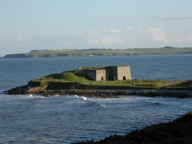
Boddin Point is a prominent coastal feature located in Angus, Scotland. Situated at the easternmost point of Lunan Bay, this headland juts out into the North Sea, offering stunning panoramic views of the surrounding landscape.

The point itself is characterized by rugged cliffs that rise up to approximately 50 meters in height, providing a dramatic backdrop to the crashing waves below. The exposed nature of the headland makes it an ideal spot for birdwatching, as various seabirds can often be seen nesting and soaring above the cliffs. Visitors can expect to witness species such as gannets, kittiwakes, and fulmars in their natural habitat.

Boddin Point is accessible via a coastal path that winds its way along the clifftops, offering visitors an opportunity to explore the area and enjoy its natural beauty. The path is well-maintained and provides an easy walk for individuals of all ages and abilities.

In addition to its stunning natural features, Boddin Point is also steeped in history. The remains of an ancient fortification, believed to date back to the Iron Age, can be found on the headland. This archaeological site adds an element of intrigue and historical significance to the area, making it a popular destination for history enthusiasts.

Overall, Boddin Point is a coastal gem that showcases the rugged beauty of the Angus coastline. With its breathtaking views, diverse wildlife, and historical significance, it is a must-visit destination for nature lovers and history buffs alike.

If you have any feedback on the listing, please let us know in the comments section below.

Boddin Point Images

Images are sourced within 2km of 56.670416/-2.4685578 or Grid Reference NO7153. Thanks to Geograph Open Source API. All images are credited.

North End of Lunan Beach Tide was on its way in, and a very blustery day whipping up the surf. In the distance on the RHS are The Limekilns at Boddin.
North End of Lunan Beach
Tide was on its way in, and a very blustery day whipping up the surf. In the distance on the RHS are The Limekilns at Boddin.
Road passing Nether Dysart Road passing Nether Dysart heading towards Lunan
Road passing Nether Dysart
Road passing Nether Dysart heading towards Lunan
Natural Arch One of many arches in the cliffs both north and south of Lunan Bay.
Natural Arch
One of many arches in the cliffs both north and south of Lunan Bay.
Nether Dysart Straw bales waiting to be collected at Nether Dysart Farm.
Nether Dysart
Straw bales waiting to be collected at Nether Dysart Farm.
Cave in cliffs at Lunan Bay This cave has two entrances. It is positioned near the junction of the cliffs and the sandy beach at Lunan Bay.
Cave in cliffs at Lunan Bay
This cave has two entrances. It is positioned near the junction of the cliffs and the sandy beach at Lunan Bay.
Nether Dysart
Nether Dysart
Crop field, Nether Dysart
National Cycle Route 1 heading north  At Nether Dysart.
National Cycle Route 1 heading north
At Nether Dysart.
Farmland towards East Mains of Dysart
Country road towards Ferryden
Salmon nets below cliffs at Lunan
Whelks I'm bound to get into a muddle over what these are. We always called them whelks, in contrast to the edible gastropods we call buckies (Littorina littorea). However I know that the edible ones are widely referred to as whelks or wulks or winkles, and the term buckie is applied to different gastropods in different places. Anyway, I think these are one of a number of species called dog whelks (Nucella lapillus). They are very common, but don't usually pack themselves quite so tightly together.
Whelks
I'm bound to get into a muddle over what these are. We always called them whelks, in contrast to the edible gastropods we call buckies (Littorina littorea). However I know that the edible ones are widely referred to as whelks or wulks or winkles, and the term buckie is applied to different gastropods in different places. Anyway, I think these are one of a number of species called dog whelks (Nucella lapillus). They are very common, but don't usually pack themselves quite so tightly together.
Pinnacle and a Peephole Some weirdly shaped rocke, eroded from lava of the Montrose Formation.
Pinnacle and a Peephole
Some weirdly shaped rocke, eroded from lava of the Montrose Formation.
Buried Rocks There are, no doubt, more curiously shaped rocks beneath the layer of sand that now blankets the area at the foot of the cliffs. As it is the whole of the end of the beach is made up of sandy alleyways and wider sand patches among the outcrops of rock. A great place for exploring.
Buried Rocks
There are, no doubt, more curiously shaped rocks beneath the layer of sand that now blankets the area at the foot of the cliffs. As it is the whole of the end of the beach is made up of sandy alleyways and wider sand patches among the outcrops of rock. A great place for exploring.
View through an Arch This is the view through one of the many holes and arches along this stretch of the beach.
View through an Arch
This is the view through one of the many holes and arches along this stretch of the beach.
Kittiwake Colony Normally this stack is far more densely populated with Kittiwake nests, but Kittiwakes (Rissa tridactyla) are very scarce this year. There were none at all in what is usually a much bigger colony at Red Head.
Kittiwake Colony
Normally this stack is far more densely populated with Kittiwake nests, but Kittiwakes (Rissa tridactyla) are very scarce this year. There were none at all in what is usually a much bigger colony at Red Head.
Rock Stacks The lavas at the north end of Lunan Bay have been sculpted by the sea into a series of stacks and gullies.
Rock Stacks
The lavas at the north end of Lunan Bay have been sculpted by the sea into a series of stacks and gullies.
Mouth of the Burn This is where the burn emerging from Buckie Den enters the sea. Notice the heavy shower at the far side of the bay.
Mouth of the Burn
This is where the burn emerging from Buckie Den enters the sea. Notice the heavy shower at the far side of the bay.
Show me another place!

Boddin Point is located at Grid Ref: NO7153 (Lat: 56.670416, Lng: -2.4685578)

Unitary Authority: Angus

Police Authority: Tayside

What 3 Words

///serenade.coveted.exacted. Near Montrose, Angus

Related Wikis

Boddin, Angus

Boddin is a coastal village in Angus, Scotland, two miles south of Montrose. There are lime kilns at Boddin Point. == References ==

Ferryden

Ferryden is a village in Angus, Scotland in the community council area of Ferryden & Craig. It lies southerly adjacent to the town of Montrose on the south...

Lunan Bay railway station

Lunan Bay railway station served the village of Lunan, Angus, Scotland from 1883 to 1964 on the North British, Arbroath and Montrose Railway. == History... ==

Lunan Water

The Lunan Water is an easterly flowing river in Angus, Scotland, that discharges to the North Sea 11 kilometres (6.8 mi) north of the town of Arbroath...

Lunan, Angus

Lunan is a hamlet in Angus, Scotland, in the parish of the same name, 6 kilometres (3.7 mi) south of Montrose. The hamlet overlooks Lunan Bay, which is...

Red Castle, Angus

Red Castle of Lunan is a ruined fortified house on the coast of Angus, Scotland. It is about 4 miles (6.4 km) south-southwest of Montrose. == History... ==

Arbikie distillery

Arbikie distillery is a scotch whisky, vodka and gin distillery in Inverkeilor, Angus, Scotland. == History == The distillery was built in 2013 on the...

Scurdie Ness

Scurdie Ness is a headland located on the South side of the River South Esk estuary, Montrose, Angus, Scotland. The River leads from the North Sea into...

Nearby Amenities

Located within 500m of 56.670416,-2.4685578
Created By: almien_coastlines
Source: PGS
Lat/Long: 56.672278/-2.475098
Source: PGS
Lat/Long: 56.672272/-2.4742297
Source: PGS
Lat/Long: 56.6725704/-2.4727039
Source: PGS
Lat/Long: 56.6724686/-2.4727212
Source: PGS
Lat/Long: 56.6724771/-2.4710933
Source: PGS
Lat/Long: 56.6721745/-2.4707669
Source: PGS
Lat/Long: 56.6719978/-2.4706493
Source: PGS
Lat/Long: 56.6718448/-2.4705271
Source: PGS
Lat/Long: 56.6717327/-2.4705098
Boddin
Place: hamlet
Wikidata: Q4936413
Wikipedia: en:Boddin, Angus
Lat/Long: 56.6728711/-2.4713642
Power: pole
Lat/Long: 56.6728372/-2.4706925
Power: pole
Lat/Long: 56.6734131/-2.4709524
Power: pole
Lat/Long: 56.6738961/-2.4711581
Power: pole
Lat/Long: 56.6744934/-2.471431
The data included in this document is from www.openstreetmap.org. The data is made available under ODbL.

Have you been to Boddin Point?

Leave your review of Boddin Point below (or comments, questions and feedback).