Auld Mains
Coastal Feature, Headland, Point in Angus
Scotland
Auld Mains

Auld Mains is a prominent coastal feature located in Angus, Scotland. It is a headland that extends into the North Sea, forming a distinctive point along the coastline. The headland is characterized by its rugged cliffs, which rise steeply from the sea, providing stunning panoramic views of the surrounding area.
The geology of Auld Mains is primarily composed of sandstone and shale, which have been shaped by the relentless action of wind and water over thousands of years. The cliffs exhibit dramatic formations, with layers of sedimentary rock clearly visible, showcasing the area's geological history.
Auld Mains is also known for its rich biodiversity. The headland is home to a variety of plant and animal species, including seabirds such as gannets, kittiwakes, and fulmars, which nest in the cliffs. The surrounding waters are teeming with marine life, with seals often spotted basking on the rocks, and occasional sightings of dolphins and porpoises.
The headland is a popular destination for nature enthusiasts and hikers who are drawn to its natural beauty and tranquility. Several walking trails traverse the area, providing access to the cliffs and offering breathtaking vistas of the North Sea and the coastline. Visitors can explore the rugged terrain, take in the fresh sea air, and immerse themselves in the peaceful ambiance of this coastal gem.
Overall, Auld Mains is a remarkable coastal feature, boasting stunning cliffs, diverse wildlife, and picturesque views. It is a place where nature and tranquility converge, offering a unique and memorable experience for those who venture to its shores.
If you have any feedback on the listing, please let us know in the comments section below.
Auld Mains Images
Images are sourced within 2km of 56.621334/-2.4810839 or Grid Reference NO7047. Thanks to Geograph Open Source API. All images are credited.


Auld Mains is located at Grid Ref: NO7047 (Lat: 56.621334, Lng: -2.4810839)
Unitary Authority: Angus
Police Authority: Tayside
What 3 Words
///proven.dumpling.snacks. Near Arbroath, Angus
Nearby Locations
Related Wikis
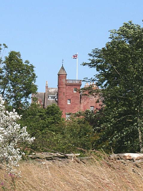
Ethie Castle
Ethie Castle is a 15,091 square feet (1,402.0 m2) 14th-century castle, situated around 3 miles north of the fishing town of Arbroath in Angus, Scotland...
Lunan Water
The Lunan Water is an easterly flowing river in Angus, Scotland, that discharges to the North Sea 11 kilometres (6.8 mi) north of the town of Arbroath...

Red Castle, Angus
Red Castle of Lunan is a ruined fortified house on the coast of Angus, Scotland. It is about 4 miles (6.4 km) south-southwest of Montrose. == History... ==

Inverkeilor railway station
Inverkeilor railway station served the village of Inverkeilor, Angus, Scotland from 1883 to 1930 on the North British, Arbroath and Montrose Railway....

Lunan, Angus
Lunan is a hamlet in Angus, Scotland, in the parish of the same name, 6 kilometres (3.7 mi) south of Montrose. The hamlet overlooks Lunan Bay, which is...

Auchmithie
Auchmithie is a small fishing village in Angus, Scotland, three miles north east of the town of Arbroath. It sits atop a cliff of red sandstone conglomerate...

Inverkeilor
Inverkeilor is a village and parish in Angus, Scotland. It lies near the North Sea coast, midway between Arbroath and Montrose. The A92 road now bypasses...

Lunan Bay railway station
Lunan Bay railway station served the village of Lunan, Angus, Scotland from 1883 to 1964 on the North British, Arbroath and Montrose Railway. == History... ==
Nearby Amenities
Located within 500m of 56.621334,-2.4810839Have you been to Auld Mains?
Leave your review of Auld Mains below (or comments, questions and feedback).