Achiemore

Settlement in Sutherland

Scotland

Achiemore

Bunkhouse and Bridge Renovated corn mill and old bridge in Strath Halladale
Bunkhouse and Bridge Credit: John MacKenzie

Achiemore is a small village located in the county of Sutherland, in the Highlands of Scotland. Situated approximately 4 miles southeast of the town of Lairg, Achiemore is nestled in a picturesque landscape surrounded by rolling hills and vast open moorland.

The village itself is home to a tight-knit community, with a population of around 100 residents. The houses in Achiemore are mostly traditional stone cottages, giving the village a charming and rustic feel. The local economy is largely based on agriculture, with farming and sheep rearing being the primary occupations of the villagers.

Achiemore is known for its tranquil and unspoiled natural beauty. The area offers numerous walking and hiking opportunities, with several scenic trails that lead to breathtaking viewpoints and waterfalls. Wildlife enthusiasts will also find plenty to explore, as the village is home to a wide variety of bird species, as well as deer and other indigenous animals.

The village lacks amenities such as shops and schools, with residents often traveling to nearby towns for their daily needs. However, Achiemore benefits from its proximity to Lairg, where residents can access a range of services and amenities, including shops, schools, and healthcare facilities.

For those seeking a peaceful and idyllic countryside setting, Achiemore presents an ideal location. Its natural beauty, close-knit community, and access to nearby towns make it an attractive place to live for those who appreciate a slower pace of life.

If you have any feedback on the listing, please let us know in the comments section below.

Achiemore Images

Images are sourced within 2km of 58.493859/-3.897529 or Grid Reference NC8957. Thanks to Geograph Open Source API. All images are credited.

Bunkhouse and Bridge Renovated corn mill and old bridge in Strath Halladale
Bunkhouse and Bridge
Renovated corn mill and old bridge in Strath Halladale
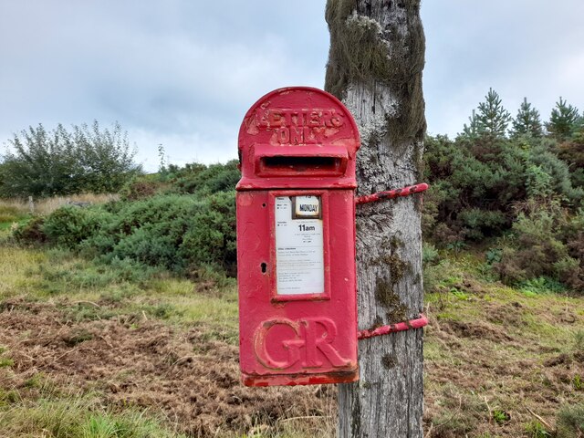
Strath Halladale: postbox № KW13 51 This small postbox is referred to on the box as "postbox no. 51 Mickleburn" although I can find no record of the name Mickleburn on the map here. The box does not appear on the Royal Mail's list but there is no doubt it is here!

The box is emptied, according to the information plate, at 11am each day (except Sunday) so, since it is after that time on a Monday and the indicator says Tuesday, the postman is obviously aware of its existence!
Strath Halladale: postbox № KW13 51
This small postbox is referred to on the box as "postbox no. 51 Mickleburn" although I can find no record of the name Mickleburn on the map here. The box does not appear on the Royal Mail's list but there is no doubt it is here! The box is emptied, according to the information plate, at 11am each day (except Sunday) so, since it is after that time on a Monday and the indicator says Tuesday, the postman is obviously aware of its existence!
River Halladale River Halladale at Craigtown
River Halladale
River Halladale at Craigtown
Halladale River north of Achiemore
Post Box at Dalhalvaig KW11 41. Royal Mail list this box as 'Bunahoun Bridge Dalhalvaig' however there is another box at that location that I cannot find listed. There is some confusion in the records I suspect. It's an example of a 'Hovis' style box from the reign of King George V.
Post Box at Dalhalvaig
KW11 41. Royal Mail list this box as 'Bunahoun Bridge Dalhalvaig' however there is another box at that location that I cannot find listed. There is some confusion in the records I suspect. It's an example of a 'Hovis' style box from the reign of King George V.
Smigel, Strath Halladale
Smigel Burn and mill View from a newer road bridge.
Smigel Burn and mill
View from a newer road bridge.
Smigel corn mill, Strath Halladale
Smigel Burn, Strath Halladale
River Halladale Looking upstream from the A897 at Connagill
River Halladale
Looking upstream from the A897 at Connagill
Lochan Dubh A small lochan with boggy margins and very dark water.
Lochan Dubh
A small lochan with boggy margins and very dark water.
Strath Halladale common grazings On its way to the Halladale river Smigel Burn has carved a deep gorge into the hillside.
Strath Halladale common grazings
On its way to the Halladale river Smigel Burn has carved a deep gorge into the hillside.
Smigel Burn coming through gorge
Smigel Burn entering gorge
Smigel Burn path approaching ford
View across Poll-Ashil from near Calgarry Beg Track through Am Bealach can be seen in background. That was the walk I was planning to take until stopped by flooded fords.
View across Poll-Ashil from near Calgarry Beg
Track through Am Bealach can be seen in background. That was the walk I was planning to take until stopped by flooded fords.
The Smigel Burn The Smigel Burn is a major tributary of the Halladale River.
The Smigel Burn
The Smigel Burn is a major tributary of the Halladale River.
Strath Halladale Moorland Moorland above Craigtown.
Strath Halladale Moorland
Moorland above Craigtown.
Show me another place!

Achiemore is located at Grid Ref: NC8957 (Lat: 58.493859, Lng: -3.897529)

Unitary Authority: Highland

Police Authority: Highlands and Islands

What 3 Words

///tucked.gardens.pans. Near Reay, Highland

Nearby Locations

Smigel Pool Achiemore

Related Wikis

Achiemore, Strath Halladale

Achiemore is a hamlet in Strath Halladale in Sutherland, in the Highland council area of Scotland. Achiemore is situated to the north of Smigel Burn on...

Upper Bighouse

Upper Bighouse is a remote linear crofting township, which lies on the west bank of the Halladale River in the former county of Sutherland. It is now in...

Strath Halladale

Strath Halladale is a strath in the traditional county of Sutherland in the north of Scotland down which the Halladale River flows to enter the Atlantic...

Dalhalvaig

Dalhalvaig (Scottish Gaelic: Dail Healabhaig) is a small crofting village, located in the right bank of the River Halladale in the Scottish council area...

Nearby Amenities

Located within 500m of 58.493859,-3.897529
Power: tower
Source: Bing
Lat/Long: 58.4912273/-3.8913194
Power: tower
Source: Bing
Lat/Long: 58.494233/-3.8907322
Passing Place
Source: Bing
Lat/Long: 58.490366/-3.8978599
Passing Place
Source: Bing
Lat/Long: 58.493855/-3.8975179
Passing Place
Source: Bing
Lat/Long: 58.4968762/-3.8981182
Passing Place
Source: Bing
Lat/Long: 58.4919935/-3.8978926
Passing Place
Source: Bing
Lat/Long: 58.4981243/-3.8983816
Passing Place
Source: Bing
Lat/Long: 58.4952623/-3.8974214
Passing Place
Source: Bing
Lat/Long: 58.4930014/-3.8977191
Post Box
Collection Times: Mo-Fr 11:00; Sa 11:00
Old Ref: TH051
Operator: Royal Mail
Post Box Design: hovis
Post Box Type: lamp
Royal Cypher: GR
Royal Cypher Wikidata: Q33102273
Lat/Long: 58.4937674/-3.8973758
Power: pole
Lat/Long: 58.4905178/-3.9003391
Power: pole
Lat/Long: 58.4914086/-3.9005033
Power: pole
Lat/Long: 58.4921808/-3.9006602
Power: pole
Lat/Long: 58.4927081/-3.9008002
Power: pole
Lat/Long: 58.4935862/-3.9010175
Power: pole
Lat/Long: 58.4944378/-3.9012541
Power: pole
Lat/Long: 58.4952427/-3.9007182
Power: pole
Lat/Long: 58.4960362/-3.9001943
Power: pole
Lat/Long: 58.496831/-3.8996728
Power: pole
Lat/Long: 58.4975551/-3.8991997
Power: pole
Lat/Long: 58.4982666/-3.898741
Power: pole
Lat/Long: 58.4963226/-3.8988243
Power: pole
Lat/Long: 58.4957637/-3.8972188
Power: pole
Lat/Long: 58.4932273/-3.8987663
Power: pole
Lat/Long: 58.4927883/-3.898228
Power: pole
Lat/Long: 58.4922003/-3.8971923
Power: pole
Lat/Long: 58.4917146/-3.8975472
Power: pole
Lat/Long: 58.4926898/-3.8968253
Power: pole
Lat/Long: 58.4932008/-3.8964463
Power: pole
Lat/Long: 58.4908844/-3.8979962
Power: pole
Lat/Long: 58.4904989/-3.8993614
Power: pole
Lat/Long: 58.4904459/-3.8987965
Power: pole
Lat/Long: 58.4903393/-3.8979829
Power: pole
Lat/Long: 58.4912482/-3.8913636
Power: pole
Lat/Long: 58.4942675/-3.8907272
The data included in this document is from www.openstreetmap.org. The data is made available under ODbL.

Have you been to Achiemore?

Leave your review of Achiemore below (or comments, questions and feedback).