Arboll, Lower

Settlement in Ross-shire

Scotland

Arboll, Lower

Beach near Inver
Beach near Inver Credit: valenta

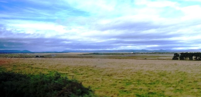
Arboll is a small village located in the Lower area of Ross-shire, Scotland. Situated on the eastern coast of the country, it is nestled between the picturesque Dornoch Firth and the rolling hills of the Scottish Highlands. With a population of around 200 residents, Arboll offers a tranquil and close-knit community atmosphere.

The village is renowned for its natural beauty, with stunning landscapes that attract visitors throughout the year. The surrounding area is characterized by lush greenery, numerous walking trails, and breathtaking coastal views. The nearby Dornoch Firth is a popular spot for fishing enthusiasts, offering ample opportunities to catch salmon or sea trout.

Despite its small size, Arboll is equipped with essential amenities to cater to its residents. It boasts a local primary school, providing education for the village's younger population. Additionally, a small convenience store meets the daily needs of the locals, while a quaint village pub serves as a social hub for gatherings and community events.

Arboll's location makes it an attractive destination for outdoor activities, such as hiking, cycling, and birdwatching. The village is also within close proximity to the historic town of Dornoch, renowned for its medieval cathedral and championship golf course.

Overall, Arboll offers a peaceful and idyllic setting for those seeking a slower pace of life and a connection with nature. Its charming community and stunning surroundings make it a hidden gem in the Ross-shire region.

If you have any feedback on the listing, please let us know in the comments section below.

Arboll, Lower Images

Images are sourced within 2km of 57.813022/-3.9204114 or Grid Reference NH8682. Thanks to Geograph Open Source API. All images are credited.

Beach near Inver
Beach near Inver
Path Inver Beach Stone monument to the mass grave of half the population of Inver, who died of the cholera epidemic of 1832.
Path Inver Beach
Stone monument to the mass grave of half the population of Inver, who died of the cholera epidemic of 1832.
Plaque Plaque to the mass grave of half the population of Inver, who died of the cholera epidemic of 1832.
Plaque
Plaque to the mass grave of half the population of Inver, who died of the cholera epidemic of 1832.
Looking towards Inver Minor road in view is Shore Street. Inver Bay and Dornoch Firth in the background.
Looking towards Inver
Minor road in view is Shore Street. Inver Bay and Dornoch Firth in the background.
Landscape from near Inver Looking from the road between Tain and Portmahomack across a flat landscape with a sweeping view towards the edge of Inver Bay, a Danger Area, the Dornoch Firth and distant mountains.
Landscape from near Inver
Looking from the road between Tain and Portmahomack across a flat landscape with a sweeping view towards the edge of Inver Bay, a Danger Area, the Dornoch Firth and distant mountains.
Low tide, Inver
Low tide, Inver
Inver School
Inver School
Shore at Inver
Shore at Inver
Shore Street, Inver
Shore Street, Inver
Inver School Inver school complete with wind turbine.
Inver School
Inver school complete with wind turbine.
Inver Bay Small boats moored in Inver Bay.
Inver Bay
Small boats moored in Inver Bay.
Inver Sculpture In a garden at Inver
Inver Sculpture
In a garden at Inver
Inver: across Inver Bay A view across the sandy bay at Inver, with the outer reaches of the Dornoch Firth visible beyond.
Inver: across Inver Bay
A view across the sandy bay at Inver, with the outer reaches of the Dornoch Firth visible beyond.
Gateway near Arboll
Gateway near Arboll
Willow-herb and pines near Arboll
Grain-fields near Arboll
Road junction near Newton
Road from Tain to Portmahomack
Show me another place!

Arboll, Lower is located at Grid Ref: NH8682 (Lat: 57.813022, Lng: -3.9204114)

Unitary Authority: Highland

Police Authority: Highlands and Islands

What 3 Words

///revamping.briskly.conqueror. Near Balintore, Highland

Related Wikis

Inver, Highland

Inver is a small village located on the south east shore of the Inver Bay at the point where the bay opens out into the Dornoch Firth and is in Ross-shire...

Arboll

Arboll (Scottish Gaelic: Àrbol) is a place in the parish of Tarbat, Easter Ross, Highland, northern Scotland made up of several scattered farms. It is...

Loch Slin Castle

Loch Slin Castle (sometimes spelt Lochslin) is a ruined castle near Fearn, Highland, Scotland. From the 15th to 17th centuries it was the seat of the Vass...

Lochslin

Lochslin (Scottish Gaelic: Loch Slinn) is a small hamlet, situated northeast of the fresh water loch, Loch Eye in Tain, Ross-shire, Scottish Highlands...

Tain Air Weapons Range

Tain Air Weapons Range is a Ministry of Defence air weapons range on the Dornoch Firth near Tain in Scotland. Royal Air Force aircrews from RAF Lossiemouth...

Morrich More

Morrich More is an extensive area of dune grassland with wetland communities, on the southern shore of the Dornoch Firth, Scotland. Morrich More lies east...

Loch Eye

Loch Eye is a shallow freshwater loch, located close to the east coast of Scotland between the Moray Firth, Dornoch Firth and Cromarty Firth. Covering...

Toulvaddie

Toulvaddie (Scottish Gaelic: Toll a' Mhadaidh) is a hamlet, in the Tarbat peninsula, located in Tain, Ross-shire, Scottish Highlands and is in the Scottish...

Nearby Amenities

Located within 500m of 57.813022,-3.9204114
Source: PGS
Lat/Long: 57.8172195/-3.9198462
Created By: dmgroom_coastlines
Source: PGS
Lat/Long: 57.817141/-3.920283
Source: PGS
Lat/Long: 57.8168144/-3.9225698
Created By: dmgroom_coastlines
Source: PGS
Lat/Long: 57.816732/-3.923631
Created By: dmgroom_coastlines
Source: PGS
Lat/Long: 57.816725/-3.92459
Source: PGS
Lat/Long: 57.8165289/-3.9249945
Power: pole
Lat/Long: 57.8159426/-3.9141931
Power: pole
Lat/Long: 57.8156681/-3.915719
Power: pole
Lat/Long: 57.8154757/-3.9167783
Power: pole
Lat/Long: 57.8153136/-3.9176427
Power: pole
Lat/Long: 57.814771/-3.9175372
Power: pole
Lat/Long: 57.8142262/-3.9174723
Power: pole
Lat/Long: 57.8136598/-3.9173749
Power: pole
Lat/Long: 57.8130589/-3.9172896
Power: pole
Lat/Long: 57.8125443/-3.9170745
Power: pole
Lat/Long: 57.8120741/-3.9168878
Power: pole
Lat/Long: 57.8110083/-3.9164901
Power: pole
Lat/Long: 57.8110321/-3.9159402
Power: pole
Lat/Long: 57.8110386/-3.9143493
Power: pole
Lat/Long: 57.8110407/-3.9134037
Power: pole
Lat/Long: 57.8149212/-3.9200636
Power: pole
Lat/Long: 57.8150909/-3.9188684
Power: pole
Lat/Long: 57.8120406/-3.9281276
Power: pole
Lat/Long: 57.8124795/-3.9272165
Power: pole
Lat/Long: 57.812981/-3.9261349
Power: pole
Lat/Long: 57.8134231/-3.9252279
Power: pole
Lat/Long: 57.8139247/-3.9241707
Power: pole
Lat/Long: 57.8143495/-3.9232778
Power: pole
Lat/Long: 57.8145256/-3.9222734
Power: pole
Lat/Long: 57.8147083/-3.9212425
Power: pole
Lat/Long: 57.8147623/-3.9235213
Power: pole
Lat/Long: 57.815186/-3.9238054
Power: pole
Lat/Long: 57.8090895/-3.9233326
Power: pole
Lat/Long: 57.8095392/-3.9224418
Power: pole
Lat/Long: 57.8099543/-3.9215773
Power: pole
Lat/Long: 57.8104018/-3.9206967
Power: pole
Lat/Long: 57.8108688/-3.9197916
The data included in this document is from www.openstreetmap.org. The data is made available under ODbL.

Have you been to Arboll, Lower?

Leave your review of Arboll, Lower below (or comments, questions and feedback).