Mu Geo

Coastal Feature, Headland, Point in Orkney

Scotland

Mu Geo

Eday Youth Hostel 1992
Eday Youth Hostel 1992 Credit: fabio sassi

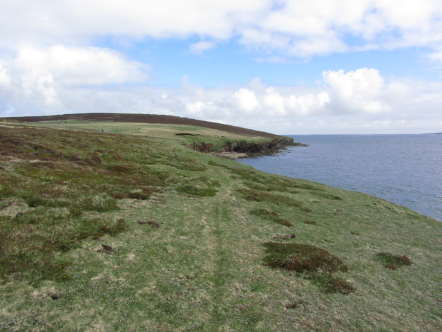
Mu Geo is a prominent coastal feature located in the Orkney Islands, an archipelago situated off the northeastern coast of Scotland. It is classified as a headland, specifically a point that extends out into the sea. Mu Geo is positioned on the western coast of the island of Mainland, the largest and most populated island within the Orkney group.

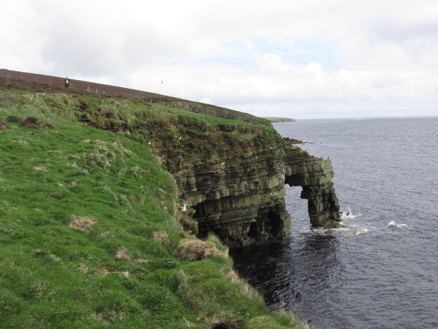
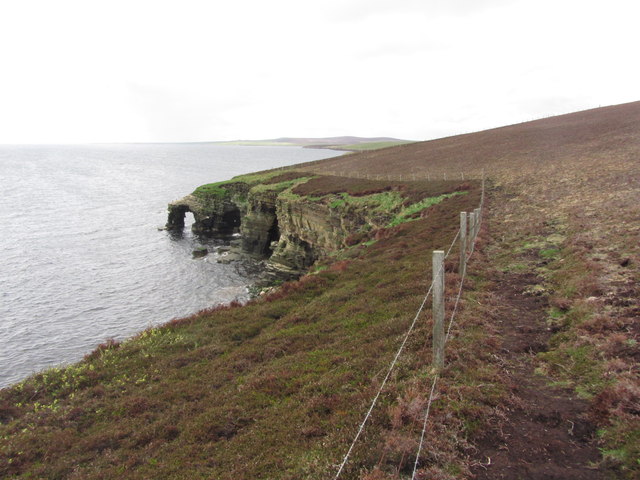
Standing tall and sturdy, Mu Geo is characterized by its rugged and imposing cliffs that rise steeply from the sea. These cliffs are composed of sandstone and have been sculpted over time by the relentless forces of erosion, resulting in striking geological formations. The headland offers breathtaking panoramic views of the surrounding sea, with clear visibility extending to neighboring islands and the vast horizon beyond.

Due to its exposed position, Mu Geo is subject to the powerful forces of the North Atlantic Ocean. Waves crash against the cliffs, relentlessly shaping the coastline and creating a dynamic environment. The headland is often buffeted by strong winds, adding to its wild and untamed allure.

Mu Geo is not only a natural spectacle but also serves as an important habitat for a diverse range of wildlife. The cliffs provide nesting sites for various seabirds, including puffins, guillemots, and razorbills. Visitors to the area have the opportunity to observe these fascinating creatures in their natural habitat, particularly during the breeding season.

Overall, Mu Geo is a captivating coastal feature that showcases the raw beauty and power of nature. Its dramatic cliffs, breathtaking views, and rich ecological significance make it a must-visit destination for nature enthusiasts and those seeking a truly immersive experience in the Orkney Islands.

If you have any feedback on the listing, please let us know in the comments section below.

Mu Geo Images

Images are sourced within 2km of 59.212346/-2.740149 or Grid Reference HY5736. Thanks to Geograph Open Source API. All images are credited.
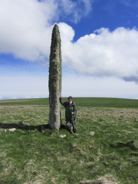
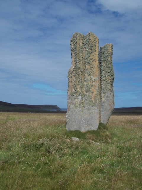
Eday Youth Hostel 1992
Eday; Walking N along coast E of Hammerhill
Eday; Stephen's Gate, Natural Arch (View N)
Eday; Stephen's Gate, Natural Arch (View S)
Eday; Stone of Setter The tallest standing stone on the Orkney Islands
Eday; Stone of Setter
The tallest standing stone on the Orkney Islands
Eday; Trig point on Stennie Hill
Greenybrae Hill Parked at Orkney Water shed and used gateways to access the moorland summit with Jim Blooker, Richard Tibbetts and Tricky Speirs.
Name: Greenybrae Hill
Hill number:12241
Height: 56m / 184ft
Parent (Ma/M):none
Area:23: Orkney Islands
Class:0
Grid ref: HY578370 (est)
Drop: 32m
Col: 24m  HY563372
Greenybrae Hill
Parked at Orkney Water shed and used gateways to access the moorland summit with Jim Blooker, Richard Tibbetts and Tricky Speirs. Name: Greenybrae Hill Hill number:12241 Height: 56m / 184ft Parent (Ma/M):none Area:23: Orkney Islands Class:0 Grid ref: HY578370 (est) Drop: 32m Col: 24m HY563372
Stennie Hill Short walk on occasionally deep heather with Jim Bloomer, Richard Tibbetts and Tricky Speirs on a sunny afternoon.
Name: Stennie Hill
Hill number:12233
Height: 66m / 217ft
Parent (Ma/M):none
Area:23: Orkney Islands
Class:0
Grid ref: HY563355 (est)
Drop: 34m
Col: 32m  HY561362
Stennie Hill
Short walk on occasionally deep heather with Jim Bloomer, Richard Tibbetts and Tricky Speirs on a sunny afternoon. Name: Stennie Hill Hill number:12233 Height: 66m / 217ft Parent (Ma/M):none Area:23: Orkney Islands Class:0 Grid ref: HY563355 (est) Drop: 34m Col: 32m HY561362
Eday: the old Faray postbox This stone-built structure looks rather like it once contained a postbox, and indeed it did: and a postbox which had a specific function.

A lady has contacted me with the following information: The pillar contained a postbox until 1947, and it was used for post for the island of Faray, off the west of Eday. A Faray islander would come across each week and collect their mail from here. [Faray has been uninhabited since 1947, so this story fits perfectly.]
Eday: the old Faray postbox
This stone-built structure looks rather like it once contained a postbox, and indeed it did: and a postbox which had a specific function. A lady has contacted me with the following information: The pillar contained a postbox until 1947, and it was used for post for the island of Faray, off the west of Eday. A Faray islander would come across each week and collect their mail from here. [Faray has been uninhabited since 1947, so this story fits perfectly.]
Eday: postbox № KW17 89 and phone This postbox is of a modern design, constructed of pressed steel and designed to be more robust, rustproof and theft-proof than the traditional cast iron box that it will have replaced in the last couple of years.

The postbox, along with traditional red phone box, stands outside the community shop and post office. While in the midst of redevelopment, the shop currently occupies a large outbuilding at the back, and the post office counter is within a large empty building.
Eday: postbox № KW17 89 and phone
This postbox is of a modern design, constructed of pressed steel and designed to be more robust, rustproof and theft-proof than the traditional cast iron box that it will have replaced in the last couple of years. The postbox, along with traditional red phone box, stands outside the community shop and post office. While in the midst of redevelopment, the shop currently occupies a large outbuilding at the back, and the post office counter is within a large empty building.
Eday: postbox № KW17 101 This postbox is of a modern design, constructed of pressed steel and designed to be more robust, rustproof and theft-proof than the traditional cast iron box that it will have replaced in the last couple of years.

It is the most northerly of the four boxes on the island, all of the same design.
Eday: postbox № KW17 101
This postbox is of a modern design, constructed of pressed steel and designed to be more robust, rustproof and theft-proof than the traditional cast iron box that it will have replaced in the last couple of years. It is the most northerly of the four boxes on the island, all of the same design.
Eday: the Stone of Setter An ancient standing stone, standing 15 feet in height, as is perhaps not evident from the photo.
Eday: the Stone of Setter
An ancient standing stone, standing 15 feet in height, as is perhaps not evident from the photo.
Eday: Mill Bay A long, narrowish inlet seen at low tide. The island of Sanday can be seen in the distance.
Eday: Mill Bay
A long, narrowish inlet seen at low tide. The island of Sanday can be seen in the distance.
Calf Sound Between Eday and Calf of Eday. View from Gump of Spurness on Sanday.
Calf Sound
Between Eday and Calf of Eday. View from Gump of Spurness on Sanday.
Old Milestone by the B9063, Millbounds, Eday parish Milestone by the B9063, in parish of Eday (District), at passing place opposite a white house, by wall.

Inscription reads:-
: G / 4½ : : C / 2 :
(To Greentoft and Carrick)

Surveyed

Milestone Society National ID: OR_EDAY04
Old Milestone by the B9063, Millbounds, Eday parish
Milestone by the B9063, in parish of Eday (District), at passing place opposite a white house, by wall. Inscription reads:- : G / 4½ : : C / 2 : (To Greentoft and Carrick) Surveyed Milestone Society National ID: OR_EDAY04
Old Milestone by the B9063, Eday parish Milestone by the B9063, in parish of Eday (District), near electricity pole 53, in front of wire fence, East side of road.

Inscription reads:-
: G / 5½ : : C / 1 :
(To Greentoft and Carrick)

Surveyed

Milestone Society National ID: OR_EDAY05
Old Milestone by the B9063, Eday parish
Milestone by the B9063, in parish of Eday (District), near electricity pole 53, in front of wire fence, East side of road. Inscription reads:- : G / 5½ : : C / 1 : (To Greentoft and Carrick) Surveyed Milestone Society National ID: OR_EDAY05
Island milestone One of 3 milestones on the 6 mile long island of Eday. G is Greentoft, the old ferry landing in the south; C is Carrick, north end of island
Island milestone
One of 3 milestones on the 6 mile long island of Eday. G is Greentoft, the old ferry landing in the south; C is Carrick, north end of island
Calfsound from Eday Calf Island across the Sound and Sanday in the distance across Lashy Sound
Calfsound from Eday
Calf Island across the Sound and Sanday in the distance across Lashy Sound
Show me another place!

Mu Geo is located at Grid Ref: HY5736 (Lat: 59.212346, Lng: -2.740149)

Unitary Authority: Orkney Islands

Police Authority: Highlands and Islands

What 3 Words

///thumbnail.loser.prevented. Near Backaland, Orkney Islands

Related Wikis

Calf of Eday

The Calf of Eday (Scots: Cauf o Aidee; Old Norse: Kalfr) is an uninhabited island in Orkney, Scotland, lying north east of Eday. It is known for its wildlife...

Vinquoy chambered cairn

Vinquoy chambered cairn (grid reference HY56013809) is a Neolithic chambered cairn located on the island of Eday, in Orkney, Scotland. The tomb probably...

Sanday Light Railway

The Sanday Light Railway was a privately owned ridable miniature railway situated in Braeswick, on the island of Sanday, Orkney, Scotland. The railway...

Eday Airport

Eday London Airport (IATA: EOI, ICAO: EGED) is located on Eday in Orkney, Scotland. As it is close to the Bay of London it is known locally as just London...

Have you been to Mu Geo?

Leave your review of Mu Geo below (or comments, questions and feedback).