Northquoy

Coastal Feature, Headland, Point in Orkney

Scotland

Northquoy

Mirkady Point, Deerness, from the air
Mirkady Point, Deerness, from the air Credit: Mike Pennington

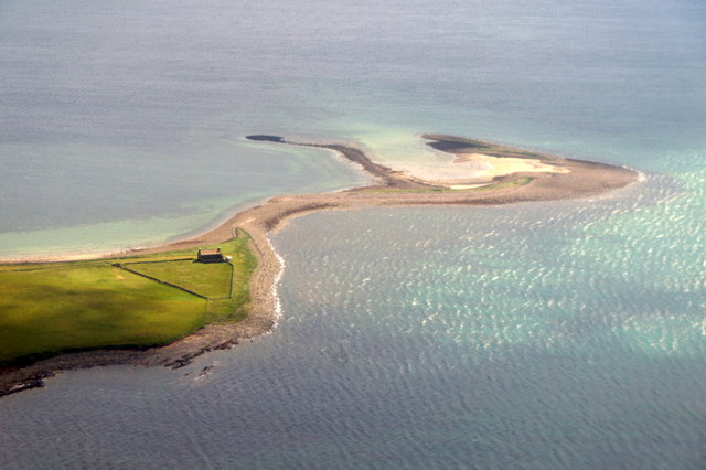
Northquoy is a prominent headland located on the Orkney Islands, an archipelago situated off the northeastern coast of Scotland. Also known as Northquoy Point, it marks the northernmost tip of the island of Westray, which is part of the Orkney mainland.

Rising approximately 30 meters above sea level, Northquoy offers breathtaking panoramic views of the surrounding North Sea and the neighboring islands. Its rugged and rocky coastal cliffs provide a dramatic backdrop to the area's natural beauty. The headland is characterized by its unique geological formations, with layers of sedimentary rocks, including sandstone and limestone, dating back millions of years.

The site is of great importance for its wildlife, with numerous seabird colonies nesting along the cliffs. Visitors can spot a variety of species, including guillemots, razorbills, puffins, and fulmars. The coastal waters around Northquoy are also home to seals, porpoises, and occasionally, even whales.

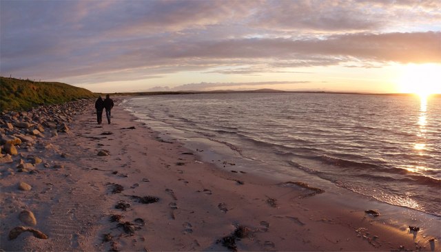
Northquoy is a popular destination for nature enthusiasts, hikers, and birdwatchers who come to explore the headland's rugged beauty and observe its diverse wildlife. The area is accessible by foot, with a well-marked coastal path leading visitors from the nearby village of Pierowall to the headland. The path offers stunning views and opportunities to encounter various plant and animal species along the way.

Overall, Northquoy is a captivating coastal feature that showcases the stunning natural landscape and rich biodiversity of the Orkney Islands.

If you have any feedback on the listing, please let us know in the comments section below.

Northquoy Images

Images are sourced within 2km of 58.948514/-2.8046687 or Grid Reference HY5307. Thanks to Geograph Open Source API. All images are credited.

Mirkady Point, Deerness, from the air
Keigar and Eve's Loch, Deerness, from the air
Od Points On Mirkady Point one looks south and left to Scarf Point and right, here, to the Point of Od.
Oddly, another is nearby <a href="https://www.geograph.org.uk/photo/2720656">HY5404 : The Point of Od</a>
Od Points
On Mirkady Point one looks south and left to Scarf Point and right, here, to the Point of Od. Oddly, another is nearby HY5404 : The Point of Od
Mirkady Herring Curing Station The building is well photographed but its history is not widely known.
Built in 1846 by Mr Groat of Newhall it was used for about 30 years as a Herring Curing Station. It is remarkably intact and now a Cat. B listed building.
More information here <span class="nowrap"><a title="http://canmore.rcahms.gov.uk/en/site/3013/details/mirkady+point+herring+curing+station/" rel="nofollow ugc noopener" href="http://canmore.rcahms.gov.uk/en/site/3013/details/mirkady+point+herring+curing+station/">Link</a><img style="margin-left:2px;" alt="External link" title="External link - shift click to open in new window" src="https://s1.geograph.org.uk/img/external.png" width="10" height="10"/></span> and <span class="nowrap"><a title="http://www.britishlistedbuildings.co.uk/sc-46146-deerness-mirkady-point-mirkady-fishing-st" rel="nofollow ugc noopener" href="http://www.britishlistedbuildings.co.uk/sc-46146-deerness-mirkady-point-mirkady-fishing-st">Link</a><img style="margin-left:2px;" alt="External link" title="External link - shift click to open in new window" src="https://s1.geograph.org.uk/img/external.png" width="10" height="10"/></span>
Mirkady Herring Curing Station
The building is well photographed but its history is not widely known. Built in 1846 by Mr Groat of Newhall it was used for about 30 years as a Herring Curing Station. It is remarkably intact and now a Cat. B listed building. More information here LinkExternal link and LinkExternal link
The Old House, Mikardy Point Late on a summers evening just after sunset the yellow lichen on the roof of the old house at Mikardy Point shows up well against the steely blue sky.
Apparently an old herring curing station.:-
<a title="https://www.geograph.org.uk/photo/2723377" href="https://www.geograph.org.uk/photo/2723377">Link</a>
The Old House, Mikardy Point
Late on a summers evening just after sunset the yellow lichen on the roof of the old house at Mikardy Point shows up well against the steely blue sky. Apparently an old herring curing station.:- Link
Hurnip's Point View Half an hour after sunset and the light is stunning. The old herring station at Mikardy Point seen from Hurnip's Point. Beyond is Wideford Hill above Kirkwall.
Hurnip's Point View
Half an hour after sunset and the light is stunning. The old herring station at Mikardy Point seen from Hurnip's Point. Beyond is Wideford Hill above Kirkwall.
Orcadian Summer Sky Heading towards midnight and the light is moving round to the north - a typical orcadian sky in the summertime - when the weather is fine!
Looking towards Mikardy Point from Braebuster.
Orcadian Summer Sky
Heading towards midnight and the light is moving round to the north - a typical orcadian sky in the summertime - when the weather is fine! Looking towards Mikardy Point from Braebuster.
Halley Beach Sunset Enjoying the late Orcadian evening on Halley Beach, Deerness - the sun is just about to set over Tankerness.
Halley Beach Sunset
Enjoying the late Orcadian evening on Halley Beach, Deerness - the sun is just about to set over Tankerness.
Deerness, Orkney, loch and farmland New Year's Day 2006, Braebuster House and farm steading on the skyline.
Deerness, Orkney, loch and farmland
New Year's Day 2006, Braebuster House and farm steading on the skyline.
High tide, jetty, Tankerness High tide on a windy day at jetty near Hall of Tankerness.
High tide, jetty, Tankerness
High tide on a windy day at jetty near Hall of Tankerness.
Halley Beach, Deerness A north-facing beach with shallow waters in Deerness.  Seals can be seen here frequently, and the clarity of the water is such that they can be seen to be "hanging" in the water.
Halley Beach, Deerness
A north-facing beach with shallow waters in Deerness. Seals can be seen here frequently, and the clarity of the water is such that they can be seen to be "hanging" in the water.
Foreshore at end of Halley Beach, Deerness The white sand beach gives way to rock outcroppings and stones at the easterly end.  This area is very rich in birdlife.
Foreshore at end of Halley Beach, Deerness
The white sand beach gives way to rock outcroppings and stones at the easterly end. This area is very rich in birdlife.
Eves Loch and Eves Howe, Deerness This small loch is close to the shore and well away from any roads or paths, so birdlife here is extraordinarily rich.  The howe, or broch, is the "lump" of land in the top right of the picture.  The stone standing in the water is probably a "straining post" used to tension a wire fence to prevent cattle from getting from one field to the next by wading in the loch.
Eves Loch and Eves Howe, Deerness
This small loch is close to the shore and well away from any roads or paths, so birdlife here is extraordinarily rich. The howe, or broch, is the "lump" of land in the top right of the picture. The stone standing in the water is probably a "straining post" used to tension a wire fence to prevent cattle from getting from one field to the next by wading in the loch.
Abandoned farmhouse of Mirkady, Deerness This old farmhouse stands alone on a finger of land known as Mirkady Point, which projects into Deer Sound.  Mirkady Point is no more than a couple of metres above sea level at the most and the shallow water of Deer Sound and the shelter it provides means that the beach slopes very gently, making for a prominent rocky foreshore.
Abandoned farmhouse of Mirkady, Deerness
This old farmhouse stands alone on a finger of land known as Mirkady Point, which projects into Deer Sound. Mirkady Point is no more than a couple of metres above sea level at the most and the shallow water of Deer Sound and the shelter it provides means that the beach slopes very gently, making for a prominent rocky foreshore.
Mirkady Point, Deerness This is the view to the southeast towards Hurnip's Point, showing the low-lying nature of the land around the sheltered Deer Sound.  It contrasts with the large cliffs typical of the easterly-facing coastline.
Mirkady Point, Deerness
This is the view to the southeast towards Hurnip's Point, showing the low-lying nature of the land around the sheltered Deer Sound. It contrasts with the large cliffs typical of the easterly-facing coastline.
Typical farmland and settlement This small settlement doesn't have a name as such, but enjoys a fabulous view over St Peter's Pool and Deer Sound, including Mirkady Point.
Typical farmland and settlement
This small settlement doesn't have a name as such, but enjoys a fabulous view over St Peter's Pool and Deer Sound, including Mirkady Point.
Braebuster House, Deerness Visible for miles around, Braebuster House is a well-known landmark, sitting in open farmland which slopes down to Deer Sound and the Oyster Skerries.
Braebuster House, Deerness
Visible for miles around, Braebuster House is a well-known landmark, sitting in open farmland which slopes down to Deer Sound and the Oyster Skerries.
Settlement at Keigar, Deerness This settlement is on the B9051 minor road with passing places, approaching Halley Beach (SY5507).  The land visible at the far side of the water is the Parish of Tankerness, behind that, the hills (SY4111) behind Kirkwall (SY4510).
Settlement at Keigar, Deerness
This settlement is on the B9051 minor road with passing places, approaching Halley Beach (SY5507). The land visible at the far side of the water is the Parish of Tankerness, behind that, the hills (SY4111) behind Kirkwall (SY4510).
Show me another place!

Northquoy is located at Grid Ref: HY5307 (Lat: 58.948514, Lng: -2.8046687)

Unitary Authority: Orkney Islands

Police Authority: Highlands and Islands

What 3 Words

///painted.daydream.assist. Near Tankerness, Orkney Islands

Nearby Locations

Northquoy

Related Wikis

Tankerness

Tankerness is a district in the St Andrews parish in Mainland, Orkney, Scotland. Essentially a peninsula, it is about 13 kilometres (8 mi) south-east of...

Toab, Orkney

Toab is a parish on the Orkney Mainland, situated in the East Mainland. Toab is located off the A960 road at the head of Deer Sound on the Mainland, Orkney...

Deerness

Deerness (, locally , Old Norse: Dyrnes) is a quoad sacra parish (i.e. one created and functioning for ecclesiastical purposes only) and peninsula in Mainland...

Mine Howe

Mine Howe is an Iron Age subterranean man-made chamber dug 6 meters (20 feet) deep inside a large mound. It is located in the Tankerness area of Orkney...

St Peter's Pool, Orkney

St Peter's Pool is a bay in the East Mainland of Orkney, Scotland. This bay was the site of significant coastal defences during World War II, when a German...

Loch of Tankerness

Loch of Tankerness is a large, lowland, freshwater loch on the Orkney mainland in Scotland. The loch is roughly triangular in shape and is shallow with...

St Andrews, Orkney

St Andrews is a parish on Mainland, Orkney in Scotland. It is located east of the town of Kirkwall and the parish of St Ola and lies north of Holm and...

The Gloup

The Gloup () is a collapsed sea cave in the Mull Head Nature Reserve in the islands of Orkney, Scotland. The name derives from the Old Norse "gluppa",...

Nearby Amenities

Located within 500m of 58.948514,-2.8046687
Power: pole
Lat/Long: 58.9470973/-2.798295
The data included in this document is from www.openstreetmap.org. The data is made available under ODbL.

Have you been to Northquoy?

Leave your review of Northquoy below (or comments, questions and feedback).