Marys Geo

Coastal Feature, Headland, Point in Orkney

Scotland

Marys Geo

Walking on Papa Westray
Walking on Papa Westray Credit: stalked

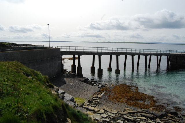
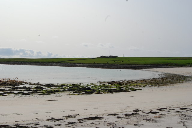
Marys Geo is a prominent coastal feature located in Orkney, a group of islands in Scotland. It is specifically situated on the island of Sanday, which is known for its picturesque landscapes and stunning natural formations. Marys Geo is characterized as a headland or point, jutting out into the North Sea.

This coastal feature is named after Mary, a historical figure who is believed to have lived in the area centuries ago. Marys Geo is composed of rugged cliffs, with its highest point reaching approximately 30 meters above sea level. The cliffs are made up of sedimentary rocks, displaying layers of different colors and textures.

The headland offers breathtaking panoramic views of the surrounding coastline, making it a popular spot for tourists and nature enthusiasts. From Marys Geo, visitors can admire the crystal-clear waters of the North Sea, observe diverse bird species that inhabit the area, and even spot seals basking on the offshore rocks. The headland is also home to various plant species, adding to its natural beauty.

Marys Geo is accessible by foot, with a well-maintained path leading to the edge of the headland. Visitors can explore the area, take photographs, and simply enjoy the tranquility and serenity that this coastal feature offers. Its unique geological formations and stunning vistas make Marys Geo a must-visit destination for anyone exploring the captivating landscapes of Orkney.

If you have any feedback on the listing, please let us know in the comments section below.

Marys Geo Images

Images are sourced within 2km of 59.324859/-2.8858229 or Grid Reference HY4949. Thanks to Geograph Open Source API. All images are credited.

Walking on Papa Westray
Remains of a Fence The stile for crossing the fence is still standing, but the fence it used to cross has gone.
Remains of a Fence
The stile for crossing the fence is still standing, but the fence it used to cross has gone.
Zigzag Rocks I assume that the sea, having detached parts of the bedrock, has flipped the loose slabs over so that they are lying at an angle to the bedrock. I could have examined them more closely to test this hypothesis, but we were anxious to get to the pier in good time for our ferry, and my walking companion is not interested in geology and would have demurred.
Zigzag Rocks
I assume that the sea, having detached parts of the bedrock, has flipped the loose slabs over so that they are lying at an angle to the bedrock. I could have examined them more closely to test this hypothesis, but we were anxious to get to the pier in good time for our ferry, and my walking companion is not interested in geology and would have demurred.
Bay of Burland The farm in the distance is called Blossom. At the far side of the bay is Redcraig Geo.
Bay of Burland
The farm in the distance is called Blossom. At the far side of the bay is Redcraig Geo.
Pits, Bull Flag, Papa Westray, Orkney From <span class="nowrap"><a title="http://canmore.org.uk/event/639213" rel="nofollow ugc noopener" href="http://canmore.org.uk/event/639213">Link</a><img style="margin-left:2px;" alt="External link" title="External link - shift click to open in new window" src="https://s1.geograph.org.uk/img/external.png" width="10" height="10"/></span> : "A series of oval/amorphous scooped areas or pits may be kelp pits or quarry hollows. They measure 8m by 4m by 1m deep. They are filled with loose stone and are partially covered with grass."
Pits, Bull Flag, Papa Westray, Orkney
From LinkExternal link : "A series of oval/amorphous scooped areas or pits may be kelp pits or quarry hollows. They measure 8m by 4m by 1m deep. They are filled with loose stone and are partially covered with grass."
Bay of Burland, Papa Westray Looking south to the abandoned buildings at Blossom.
Bay of Burland, Papa Westray
Looking south to the abandoned buildings at Blossom.
Bay of Burland The bay contains several small shingle beaches between rocky outcrops. The nearer farm is Blossom and the one on the horizon is Sheepheight.
Bay of Burland
The bay contains several small shingle beaches between rocky outcrops. The nearer farm is Blossom and the one on the horizon is Sheepheight.
Bay of Burland It looks as if people still come here, although the access is by rough or faint tracks and paths. Someone has coiled a rope and laid a float on top of it.
Bay of Burland
It looks as if people still come here, although the access is by rough or faint tracks and paths. Someone has coiled a rope and laid a float on top of it.
Cuppin Cuppin stands on a low ridge between the shore and the Loch of St Tredwell. It looks as if it is abandoned.
Cuppin
Cuppin stands on a low ridge between the shore and the Loch of St Tredwell. It looks as if it is abandoned.
Track to Blossom As we feared that we were getting short of time we decided to follow a track marked on the map rather than continue round the shore. It started out fine, as you can see, but subsequently deteriorated and eventually vanished at the garden wall of Sheepheight, necessitating a diversion round Sheepheight and climbing over a couple of fences. Not recommended! The ruins on the left are at Blossom.
Track to Blossom
As we feared that we were getting short of time we decided to follow a track marked on the map rather than continue round the shore. It started out fine, as you can see, but subsequently deteriorated and eventually vanished at the garden wall of Sheepheight, necessitating a diversion round Sheepheight and climbing over a couple of fences. Not recommended! The ruins on the left are at Blossom.
Blossom The house and steading at Blossom are derelict and now occupied only by sheep.
Blossom
The house and steading at Blossom are derelict and now occupied only by sheep.
Papa Westray coastline The rock forms a flat shelf at this point on the coast, and the waves were sweeping across it.
Papa Westray coastline
The rock forms a flat shelf at this point on the coast, and the waves were sweeping across it.
St. Tredwell's Chapel
Gayfield Trig Point
Gayfield Trig Point
A View Across The Loch
The pier on Papa Westray
Toilet and Waiting Room on Papa Westray
Bay of Moclett, Papa Westray
Show me another place!

Marys Geo is located at Grid Ref: HY4949 (Lat: 59.324859, Lng: -2.8858229)

Unitary Authority: Orkney Islands

Police Authority: Highlands and Islands

What 3 Words

///elsewhere.price.home. Near Pierowall, Orkney Islands

Related Wikis

Holland House, Papa Westray

Holland Farm is a historic farm complex located on the island of Papa Westray in Orkney, Scotland. The two-storey harled flagstone house with crow-stepped...

Papa Westray

Papa Westray () (Scots: Papa Westree), also known as Papay, is one of the Orkney Islands in Scotland, United Kingdom. The fertile soil has long been a...

Holm of Papa

The Holm of Papa (or Holm of Papay, Holm of Papa Westray and known locally as the Papay Holm,) is a very small uninhabited island in the Orkney Islands...

Knap of Howar

The Knap of Howar () on the island of Papa Westray in Orkney, Scotland is a Neolithic farmstead which may be the oldest preserved stone house in northern...

Nearby Amenities

Located within 500m of 59.324859,-2.8858229
Ferry Terminal
Papa Westray Ferry Terminal
Ferry: yes
Public Transport: station
Seamark Light 1 Character: Fl
Seamark Light 1 Colour: green
Seamark Light 1 Height: 7
Seamark Light 1 Period: 5
Seamark Light 1 Range: 3
Seamark Light 1 Sector End: 341
Seamark Light 1 Sector Start: 306
Seamark Light 1 Sequence: 1+(4)
Seamark Light 2 Character: Fl
Seamark Light 2 Colour: white
Seamark Light 2 Height: 7
Seamark Light 2 Period: 5
Seamark Light 2 Range: 5
Seamark Light 2 Sector End: 40
Seamark Light 2 Sector Start: 341
Seamark Light 2 Sequence: 1+(4)
Seamark Light 3 Character: Fl
Seamark Light 3 Colour: red
Seamark Light 3 Height: 7
Seamark Light 3 Period: 5
Seamark Light 3 Range: 3
Seamark Light 3 Sector End: 74
Seamark Light 3 Sector Start: 40
Seamark Light 3 Sequence: 1+(4)
Seamark Light Reference: A 3738
Seamark Type: light_minor
Source: US NGA Pub. 114. 2011-05-26.
Lat/Long: 59.3267767/-2.8918735
Power: pole
Lat/Long: 59.3272858/-2.8896618
Power: pole
Lat/Long: 59.3276826/-2.8887633
Power: pole
Lat/Long: 59.3286568/-2.8866282
Power: pole
Lat/Long: 59.3280479/-2.8879318
Power: pole
Lat/Long: 59.32852/-2.889128
The data included in this document is from www.openstreetmap.org. The data is made available under ODbL.

Have you been to Marys Geo?

Leave your review of Marys Geo below (or comments, questions and feedback).