Knocking Stone

Coastal Feature, Headland, Point in Caithness

Scotland

Knocking Stone

Duncansby Head Trig Point Duncansby Head Trig Point is close to the summit of Duncansby Head TUMP which is fenced off.
Name: Duncansby Head
Hill number: 10048
Height: 64m / 210ft
Parent (Ma/M): 1150  Morven
Section: 16C: Tongue to Wick and Helmsdale
County/UA: Highland (UA)
Class: Tump (0-99m)
Grid ref: ND 40554 73241
Summit feature: no feature
Drop: 42m
Col: 22m  ND402727
Duncansby Head Trig Point Credit: Rude Health

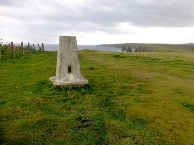
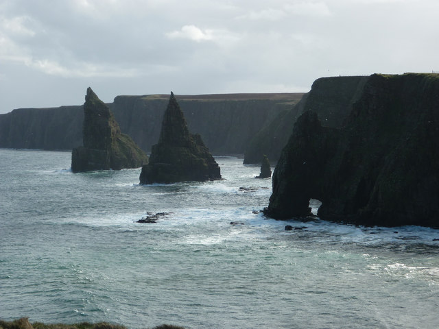
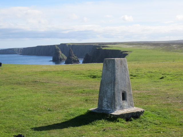
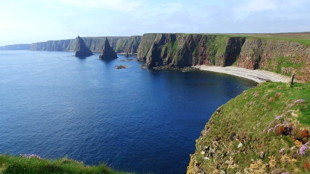
Knocking Stone is a prominent coastal feature located in the county of Caithness, Scotland. Situated on the east coast of the county, it is a striking headland that juts out into the North Sea. The name "Knocking Stone" is derived from the large stone formation found at the tip of the headland, which is said to emit a distinctive knocking sound when struck by the waves.

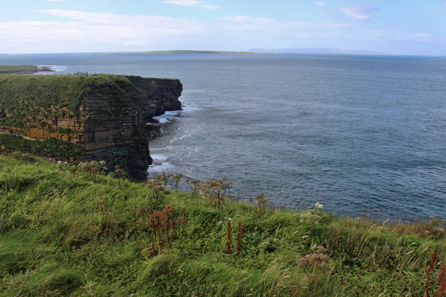
The headland is composed of rugged cliffs, formed from layers of sandstone and shale, which have been eroded over centuries by the relentless force of the sea. The cliffs rise to a considerable height, offering breathtaking views of the surrounding coastline, with the ocean stretching out to the horizon.

Knocking Stone is known for its dramatic and picturesque beauty, attracting both locals and tourists alike. The headland is a popular spot for nature enthusiasts, who come to observe the diverse marine life and seabirds that inhabit the area. Visitors can often spot gulls, fulmars, and even puffins nesting in the crevices of the cliffs.

The site is also of historical significance, as it is believed to have been used as a lookout point during ancient times. Archaeological evidence suggests that the area was inhabited by early settlers, who utilized the headland's strategic position to monitor the coastline and protect their communities from potential threats.

Overall, Knocking Stone in Caithness is a captivating coastal feature that combines natural beauty, geological interest, and historical significance. It provides a unique and memorable experience for those who venture to its windswept cliffs and listen to the echoing knocks of the stone.

If you have any feedback on the listing, please let us know in the comments section below.

Knocking Stone Images

Images are sourced within 2km of 58.645178/-3.0599928 or Grid Reference ND3873. Thanks to Geograph Open Source API. All images are credited.

Duncansby Head Trig Point Duncansby Head Trig Point is close to the summit of Duncansby Head TUMP which is fenced off.
Name: Duncansby Head
Hill number: 10048
Height: 64m / 210ft
Parent (Ma/M): 1150  Morven
Section: 16C: Tongue to Wick and Helmsdale
County/UA: Highland (UA)
Class: Tump (0-99m)
Grid ref: ND 40554 73241
Summit feature: no feature
Drop: 42m
Col: 22m  ND402727
Duncansby Head Trig Point
Duncansby Head Trig Point is close to the summit of Duncansby Head TUMP which is fenced off. Name: Duncansby Head Hill number: 10048 Height: 64m / 210ft Parent (Ma/M): 1150 Morven Section: 16C: Tongue to Wick and Helmsdale County/UA: Highland (UA) Class: Tump (0-99m) Grid ref: ND 40554 73241 Summit feature: no feature Drop: 42m Col: 22m ND402727
Duncansby Stacks These impressive sea stacks are just south of Duncansby Head in the far North East of Scotland.
Duncansby Stacks
These impressive sea stacks are just south of Duncansby Head in the far North East of Scotland.
Trig Point at Duncansby Head Stacks of Duncansby in the background
Trig Point at Duncansby Head
Stacks of Duncansby in the background
Sea cliffs at Duncansby Head Orkney Isles on the horizon.
Sea cliffs at Duncansby Head
Orkney Isles on the horizon.
Thirle Door and the Stacks of Duncansby
Trig point at Duncansby Head The lighthouse in the distance.
Trig point at Duncansby Head
The lighthouse in the distance.
Triangulation Pillar The trig point is 64 metres above sea level. In the background is the Duncasby Head lighthouse.
Triangulation Pillar
The trig point is 64 metres above sea level. In the background is the Duncasby Head lighthouse.
Car park and sign, Duncansby Head, 1992
Fence near Hillhead
Fence near Hillhead
Puddles in the road
Puddles in the road
Geo of Sclaites Geo of Sclaites near John O' Groats.
Geo of Sclaites
Geo of Sclaites near John O' Groats.
Duncansby Head ROC Post and Lighthouse
Unslightly bales dumped at car park
Trig point and lighthouse, Duncansby Head Flush bracket S6678
Trig point and lighthouse, Duncansby Head
Flush bracket S6678
Cotton Grass View of some cotton grass whilst looking towards Duncansby Stacks.
Cotton Grass
View of some cotton grass whilst looking towards Duncansby Stacks.
Duncansby Head Trig point and lighthouse.
Duncansby Head
Trig point and lighthouse.
Duncansby Head: view from the Orkney ferry Looking roughly southeast towards the northeastern tip of mainland Britain, from the ferry which runs from nearby Gills Bay to St. Margaret's Hope on Orkney.
Duncansby Head: view from the Orkney ferry
Looking roughly southeast towards the northeastern tip of mainland Britain, from the ferry which runs from nearby Gills Bay to St. Margaret's Hope on Orkney.
Little and large The scale of the two "witches hat" Stacks of Duncansby is evident compared to the two small figures near the cliff edge.
Little and large
The scale of the two "witches hat" Stacks of Duncansby is evident compared to the two small figures near the cliff edge.
Show me another place!

Knocking Stone is located at Grid Ref: ND3873 (Lat: 58.645178, Lng: -3.0599928)

Unitary Authority: Highland

Police Authority: Highlands and Islands

What 3 Words

///profited.basic.almost. Near John o' Groats, Highland

Related Wikis

John o' Groats

John O' Groats (Scottish Gaelic: Taigh Iain Ghròt) is a village 2.5 mi (4 km) northeast of Canisbay, Caithness, in the far north of Scotland. John O' Groats...

Huna, Caithness

Huna is a small remote crofting township, located 1 mile northeast of Canisbay and 1.5 miles west of John o' Groats in Caithness, in Scotland. It is currently...

Duncansby Head

Duncansby Head (Scottish Gaelic: Ceann Dhunngain or Dùn Gasbaith) is the most northeasterly part of both the Scottish and British mainlands, slightly...

Huna House

Huna House is a Victorian building located in the small village of Huna in Canisbay, north of Caithness. Built in 1870 as the Huna Hotel, it is listed...

Nearby Amenities

Located within 500m of 58.645178,-3.0599928
Source: PGS
Lat/Long: 58.6477276/-3.05339
Source: PGS
Lat/Long: 58.6469255/-3.054244
Source: PGS
Lat/Long: 58.6465364/-3.0542955
Source: PGS
Lat/Long: 58.6461986/-3.0542912
Source: PGS
Lat/Long: 58.6458157/-3.0545884
Source: PGS
Lat/Long: 58.6454121/-3.0553759
Source: PGS
Lat/Long: 58.6452502/-3.0555744
Source: PGS
Lat/Long: 58.6450844/-3.0561688
Source: PGS
Lat/Long: 58.6450213/-3.0571709
Source: PGS
Lat/Long: 58.6449844/-3.058086
Source: PGS
Lat/Long: 58.6444764/-3.0604668
Source: PGS
Lat/Long: 58.6442118/-3.0618551
Source: PGS
Lat/Long: 58.6441096/-3.0630063
Source: PGS
Lat/Long: 58.6441119/-3.0652883
Source: PGS
Lat/Long: 58.6443391/-3.0677999
Ness of Duncansby - life on the edge
Board Type: nature
Information: board
Tourism: information
Lat/Long: 58.6472875/-3.0536453
Bench
Backrest: yes
Lat/Long: 58.6472763/-3.053538
Ness of Duncansby
Place: locality
Lat/Long: 58.6471991/-3.0527458
Waste Basket
Waste: dog_excrement
Lat/Long: 58.6441926/-3.0670466
The data included in this document is from www.openstreetmap.org. The data is made available under ODbL.

Have you been to Knocking Stone?

Leave your review of Knocking Stone below (or comments, questions and feedback).