Peedie Hylack

Coastal Feature, Headland, Point in Orkney

Scotland

Peedie Hylack

Swona, Orkney, from the air
Swona, Orkney, from the air Credit: Mike Pennington

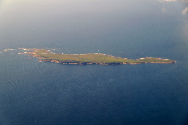
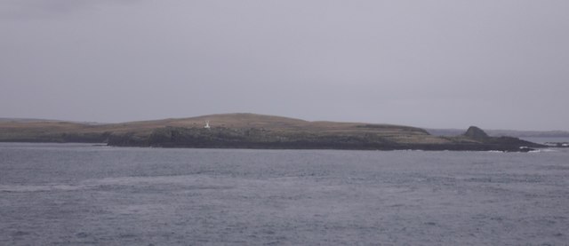
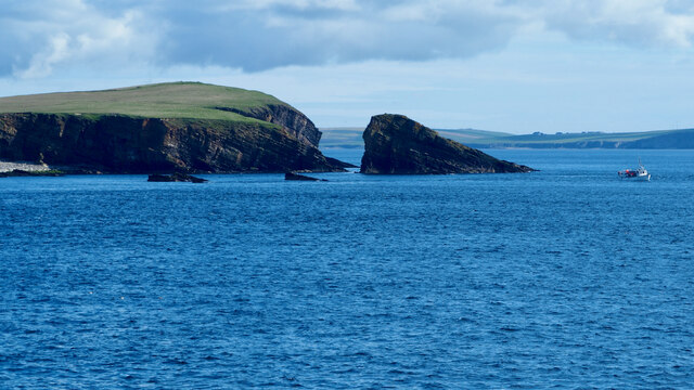
Peedie Hylack is a prominent coastal feature located in Orkney, an archipelago situated off the northeastern coast of Scotland. This remarkable headland is known for its picturesque beauty and rich cultural history.

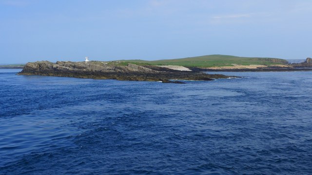
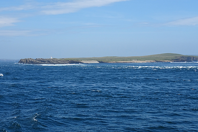
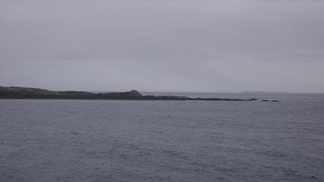
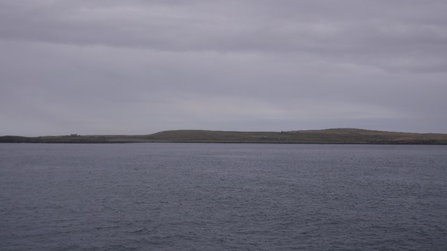
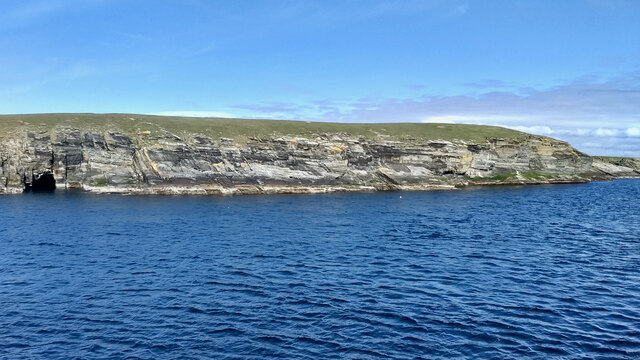
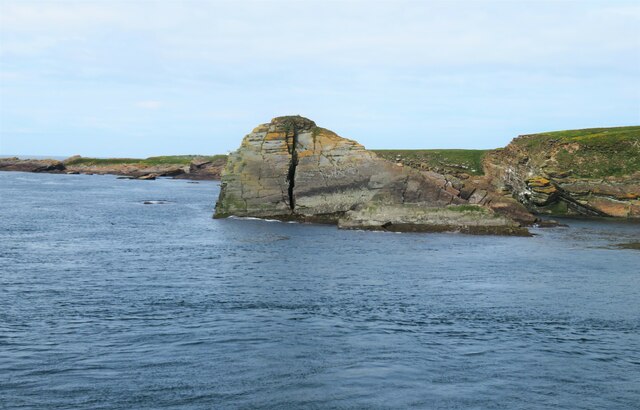
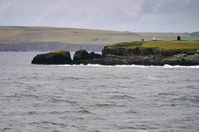
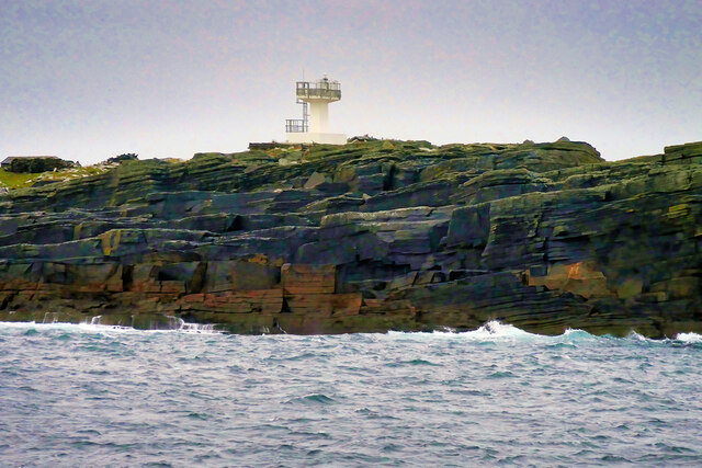
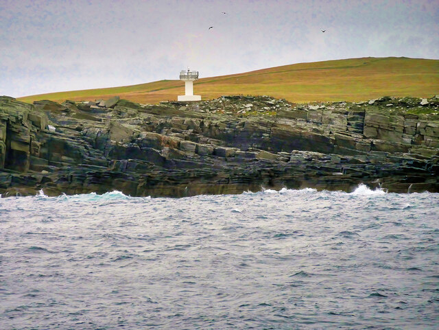
Situated on the mainland of Orkney, Peedie Hylack is characterized by its towering cliffs that overlook the North Sea. The headland extends outward into the sea, forming a distinct point that offers stunning panoramic views of the surrounding landscapes. The rugged coastline is composed of layers of sedimentary rock, showcasing the geological history of the area.

The name "Peedie Hylack" originates from the local Orcadian dialect, with "peedie" meaning small and "hylack" referring to a hill or mound. This name perfectly encapsulates the size and shape of the headland, which is relatively small compared to other coastal features in the region.

Peedie Hylack is known for its diverse wildlife and bird population. The surrounding waters provide an ideal habitat for various seabirds, including puffins, guillemots, and razorbills. Birdwatchers often visit the area to witness the impressive displays of these magnificent creatures.

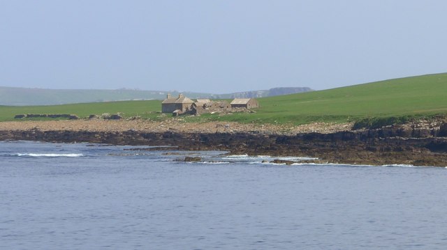
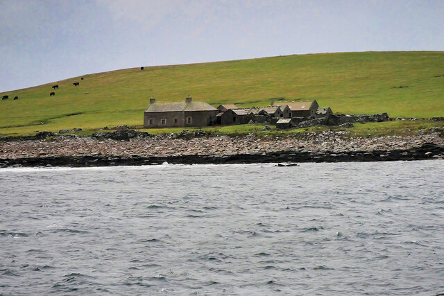
In addition to its natural beauty, Peedie Hylack holds historical significance. The headland is believed to have been an important lookout point during ancient times, serving as a vantage point for early settlers to monitor the sea and protect the surrounding area. Archaeological remains have also been discovered in the vicinity, further highlighting the historical importance of the site.

Overall, Peedie Hylack is a captivating coastal feature that offers visitors a glimpse into Orkney's natural and cultural heritage. Its stunning cliffs, diverse wildlife, and historical significance make it a popular destination for nature enthusiasts and history buffs alike.

If you have any feedback on the listing, please let us know in the comments section below.

Peedie Hylack Images

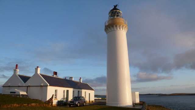
Images are sourced within 2km of 58.736478/-3.0630285 or Grid Reference ND3883. Thanks to Geograph Open Source API. All images are credited.
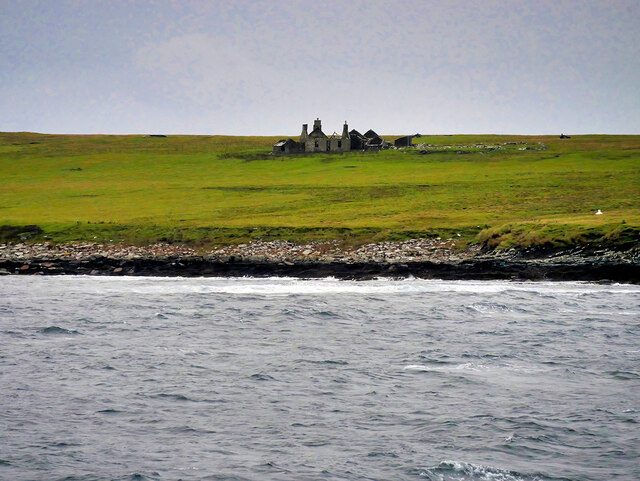
Swona, Orkney, from the air
Skerries at SW tip of Swona The navigation light visible in the background.

Photo taken from "Pentalina" ferry between Gills Bay and St Margaret's Hope.
Skerries at SW tip of Swona
The navigation light visible in the background. Photo taken from "Pentalina" ferry between Gills Bay and St Margaret's Hope.
Buildings on Swona
Buildings on Swona
Tails of the Tarf The disturbed water shows some of the dangers of the Pentland Firth for small vessels. Only a small part of the tip of the island of Swona is in this square.
Tails of the Tarf
The disturbed water shows some of the dangers of the Pentland Firth for small vessels. Only a small part of the tip of the island of Swona is in this square.
The Tarf, Swona A navigation beacon at the southern end of the island.
The Tarf, Swona
A navigation beacon at the southern end of the island.
Tails of the Tarf Skerries on the southern tip of Swona, Pentland Firth.
Tails of the Tarf
Skerries on the southern tip of Swona, Pentland Firth.
Swona View from the Pentland Ferries boat passing to the west.
Swona
View from the Pentland Ferries boat passing to the west.
Swona The island is situated in the Pentland Firth where it creates an obstruction to the strong tides producing tidal races, over-falls and whirlpools. One of these whirlpools is known as the ‘Wells of Swona’, and legend has it is caused by a witch struggling to save herself. To quote directly from Westwood and Kingshill’s book “The Lore of Scotland: A guide to Scottish legends”:

"A witch once took a fancy to a dark and handsome young man and wanted him for her lover. When she asked him to go to the beach with her, however, he refused, as his sweetheart was at that moment on her way to join him. Concealing her anger, the witch persuaded the young man and his girl to come out with her in her boat. As they approached Swona, she worked a spell on the boat and it overturned. The young man caught his girl’s hand in an attempt to save her, but at the same moment the witch caught hold of his to drag him under the waves and into her power. The three were so entangled that they could not be pulled apart. The young man and his sweetheart were drowned, but the witch is still struggling to get free, and it is her frantic churning of the waters that causes the Wells of Swona."

Adapted from my daily photo diary <span class="nowrap"><a title="http://www.fhithich.uk/?p=25760" rel="nofollow ugc noopener" href="http://www.fhithich.uk/?p=25760">Link</a><img style="margin-left:2px;" alt="External link" title="External link - shift click to open in new window" src="https://s1.geograph.org.uk/img/external.png" width="10" height="10"/></span>
Swona
The island is situated in the Pentland Firth where it creates an obstruction to the strong tides producing tidal races, over-falls and whirlpools. One of these whirlpools is known as the ‘Wells of Swona’, and legend has it is caused by a witch struggling to save herself. To quote directly from Westwood and Kingshill’s book “The Lore of Scotland: A guide to Scottish legends”: "A witch once took a fancy to a dark and handsome young man and wanted him for her lover. When she asked him to go to the beach with her, however, he refused, as his sweetheart was at that moment on her way to join him. Concealing her anger, the witch persuaded the young man and his girl to come out with her in her boat. As they approached Swona, she worked a spell on the boat and it overturned. The young man caught his girl’s hand in an attempt to save her, but at the same moment the witch caught hold of his to drag him under the waves and into her power. The three were so entangled that they could not be pulled apart. The young man and his sweetheart were drowned, but the witch is still struggling to get free, and it is her frantic churning of the waters that causes the Wells of Swona." Adapted from my daily photo diary LinkExternal link
Sooth Clett The island is situated in the Pentland Firth where it creates an obstruction to the strong tides producing tidal races, over-falls and whirlpools. One of these whirlpools is known as the ‘Wells of Swona’, and legend has it is caused by a witch struggling to save herself. To quote directly from Westwood and Kingshill’s book “The Lore of Scotland: A guide to Scottish legends”:

"A witch once took a fancy to a dark and handsome young man and wanted him for her lover. When she asked him to go to the beach with her, however, he refused, as his sweetheart was at that moment on her way to join him. Concealing her anger, the witch persuaded the young man and his girl to come out with her in her boat. As they approached Swona, she worked a spell on the boat and it overturned. The young man caught his girl’s hand in an attempt to save her, but at the same moment the witch caught hold of his to drag him under the waves and into her power. The three were so entangled that they could not be pulled apart. The young man and his sweetheart were drowned, but the witch is still struggling to get free, and it is her frantic churning of the waters that causes the Wells of Swona."

Adapted from my daily photo diary <span class="nowrap"><a title="http://www.fhithich.uk/?p=25760" rel="nofollow ugc noopener" href="http://www.fhithich.uk/?p=25760">Link</a><img style="margin-left:2px;" alt="External link" title="External link - shift click to open in new window" src="https://s1.geograph.org.uk/img/external.png" width="10" height="10"/></span>
Sooth Clett
The island is situated in the Pentland Firth where it creates an obstruction to the strong tides producing tidal races, over-falls and whirlpools. One of these whirlpools is known as the ‘Wells of Swona’, and legend has it is caused by a witch struggling to save herself. To quote directly from Westwood and Kingshill’s book “The Lore of Scotland: A guide to Scottish legends”: "A witch once took a fancy to a dark and handsome young man and wanted him for her lover. When she asked him to go to the beach with her, however, he refused, as his sweetheart was at that moment on her way to join him. Concealing her anger, the witch persuaded the young man and his girl to come out with her in her boat. As they approached Swona, she worked a spell on the boat and it overturned. The young man caught his girl’s hand in an attempt to save her, but at the same moment the witch caught hold of his to drag him under the waves and into her power. The three were so entangled that they could not be pulled apart. The young man and his sweetheart were drowned, but the witch is still struggling to get free, and it is her frantic churning of the waters that causes the Wells of Swona." Adapted from my daily photo diary LinkExternal link
Warbister Hill Site of a possible building, an enclosure, a quarry, and a modern triangulation pillar; see “Swona, Warbister Hill | Canmore.” 2021. Canmore.org.uk <<span class="nowrap"><a title="https://canmore.org.uk/site/347495/swona-warbister-hill" rel="nofollow ugc noopener" href="https://canmore.org.uk/site/347495/swona-warbister-hill">Link</a><img style="margin-left:2px;" alt="External link" title="External link - shift click to open in new window" src="https://s1.geograph.org.uk/img/external.png" width="10" height="10"/></span> > [accessed 7 June 2021]
Warbister Hill
Site of a possible building, an enclosure, a quarry, and a modern triangulation pillar; see “Swona, Warbister Hill | Canmore.” 2021. Canmore.org.uk <LinkExternal link > [accessed 7 June 2021]
The Haven Seems to be the main access onto the now un-inhabited island. See “Swona, the Haven | Canmore.” 2021. Canmore.org.uk &amp;lt;&lt;span class=&quot;nowrap&quot;&gt;&lt;a title=&quot;https://canmore.org.uk/site/347498/swona-the-haven&quot; rel=&quot;nofollow ugc noopener&quot; href=&quot;https://canmore.org.uk/site/347498/swona-the-haven&quot;&gt;Link&lt;/a&gt;&lt;img style=&quot;margin-left:2px;&quot; alt=&quot;External link&quot; title=&quot;External link - shift click to open in new window&quot; src=&quot;https://s1.geograph.org.uk/img/external.png&quot; width=&quot;10&quot; height=&quot;10&quot;/&gt;&lt;/span&gt; &amp;gt; [accessed 7 June 2021]

‌For the farmstead behind see “Swona, Norhead | Canmore.” 2021. Canmore.org.uk &amp;lt;&lt;span class=&quot;nowrap&quot;&gt;&lt;a title=&quot;https://canmore.org.uk/site/345421/swona-norhead&quot; rel=&quot;nofollow ugc noopener&quot; href=&quot;https://canmore.org.uk/site/345421/swona-norhead&quot;&gt;Link&lt;/a&gt;&lt;img style=&quot;margin-left:2px;&quot; alt=&quot;External link&quot; title=&quot;External link - shift click to open in new window&quot; src=&quot;https://s1.geograph.org.uk/img/external.png&quot; width=&quot;10&quot; height=&quot;10&quot;/&gt;&lt;/span&gt; &amp;gt; [accessed 7 June 2021]
The Haven
Seems to be the main access onto the now un-inhabited island. See “Swona, the Haven | Canmore.” 2021. Canmore.org.uk <LinkExternal link > [accessed 7 June 2021] ‌For the farmstead behind see “Swona, Norhead | Canmore.” 2021. Canmore.org.uk <LinkExternal link > [accessed 7 June 2021]
Sooth Clett, Swona A close view of this rock feature on the SE shoreline of Swona island. The Pentland Ferries ship &amp;#039;Alfred&amp;#039; took a very different course on this occasion to that taken two weeks previously, the ship hugging the coastlines of both Swona and Stroma. A fellow passenger and regular user of the ferry said that this route close to the islands is often taken depending on the state of tides and currents. On this occasion it appeared to be near full tide, but the eddies, whirlpools and sudden currents around the islands were impressive to see, even on a rare calm day on the Pentland Firth.
Sooth Clett, Swona
A close view of this rock feature on the SE shoreline of Swona island. The Pentland Ferries ship 'Alfred' took a very different course on this occasion to that taken two weeks previously, the ship hugging the coastlines of both Swona and Stroma. A fellow passenger and regular user of the ferry said that this route close to the islands is often taken depending on the state of tides and currents. On this occasion it appeared to be near full tide, but the eddies, whirlpools and sudden currents around the islands were impressive to see, even on a rare calm day on the Pentland Firth.
The Clump o' The Ness, Swona Swona is the more northerly of two islands in the Pentland Firth between the Orkney Islands and Caithness on the Scottish mainland. It lies in the southern approach to Scapa Flow, west of South Ronaldsay. It is administered as part of the Orkney Islands, while Stroma, to the south, is part of the Highland Region (although traditionally part of Caithness). There is no regular access to the island, however, the Pentland Ferries sailing between Gills Bay, near John o&amp;#039; Groats, and St Margaret&amp;#039;s Hope usually passes close to the island, dependent on the tidal direction at the time.

Swona is about 1¼ miles long by about ½ mile wide. It is made up of Old Red Sandstone with cliffs on the east coast. There are prehistoric, pre-Norse and Norse remains on the island but it has been uninhabited since 1975. The island is part of the Pentland Firth Islands Site of Special Scientific Interest (SSSI) and is home to thousands of breeding seabirds, including a colony of Arctic tern on the northern part of the island, and Atlantic puffin which burrow into the hillside.
The Clump o' The Ness, Swona
Swona is the more northerly of two islands in the Pentland Firth between the Orkney Islands and Caithness on the Scottish mainland. It lies in the southern approach to Scapa Flow, west of South Ronaldsay. It is administered as part of the Orkney Islands, while Stroma, to the south, is part of the Highland Region (although traditionally part of Caithness). There is no regular access to the island, however, the Pentland Ferries sailing between Gills Bay, near John o' Groats, and St Margaret's Hope usually passes close to the island, dependent on the tidal direction at the time. Swona is about 1¼ miles long by about ½ mile wide. It is made up of Old Red Sandstone with cliffs on the east coast. There are prehistoric, pre-Norse and Norse remains on the island but it has been uninhabited since 1975. The island is part of the Pentland Firth Islands Site of Special Scientific Interest (SSSI) and is home to thousands of breeding seabirds, including a colony of Arctic tern on the northern part of the island, and Atlantic puffin which burrow into the hillside.
Abandoned Croft on Swona Swona is the more northerly of two islands in the Pentland Firth between the Orkney Islands and Caithness on the Scottish mainland. It lies in the southern approach to Scapa Flow, west of South Ronaldsay. It is administered as part of the Orkney Islands, while Stroma, to the south, is part of the Highland Region (although traditionally part of Caithness). There is no regular access to the island, however, the Pentland Ferries sailing between Gills Bay, near John o&amp;#039; Groats, and St Margaret&amp;#039;s Hope usually passes close to the island, dependent on the tidal direction at the time.

Swona is about 1¼ miles long by about ½ mile wide. It is made up of Old Red Sandstone with cliffs on the east coast. There are prehistoric, pre-Norse and Norse remains on the island but it has been uninhabited since 1975. The island is part of the Pentland Firth Islands Site of Special Scientific Interest (SSSI) and is home to thousands of breeding seabirds, including a colony of Arctic tern on the northern part of the island, and Atlantic puffin which burrow into the hillside.
Abandoned Croft on Swona
Swona is the more northerly of two islands in the Pentland Firth between the Orkney Islands and Caithness on the Scottish mainland. It lies in the southern approach to Scapa Flow, west of South Ronaldsay. It is administered as part of the Orkney Islands, while Stroma, to the south, is part of the Highland Region (although traditionally part of Caithness). There is no regular access to the island, however, the Pentland Ferries sailing between Gills Bay, near John o' Groats, and St Margaret's Hope usually passes close to the island, dependent on the tidal direction at the time. Swona is about 1¼ miles long by about ½ mile wide. It is made up of Old Red Sandstone with cliffs on the east coast. There are prehistoric, pre-Norse and Norse remains on the island but it has been uninhabited since 1975. The island is part of the Pentland Firth Islands Site of Special Scientific Interest (SSSI) and is home to thousands of breeding seabirds, including a colony of Arctic tern on the northern part of the island, and Atlantic puffin which burrow into the hillside.
Ruined Building on Swona Swona is the more northerly of two islands in the Pentland Firth between the Orkney Islands and Caithness on the Scottish mainland. It lies in the southern approach to Scapa Flow, west of South Ronaldsay. It is administered as part of the Orkney Islands, while Stroma, to the south, is part of the Highland Region (although traditionally part of Caithness). There is no regular access to the island, however, the Pentland Ferries sailing between Gills Bay, near John o&amp;#039; Groats, and St Margaret&amp;#039;s Hope usually passes close to the island, dependent on the tidal direction at the time.

Swona is about 1¼ miles long by about ½ mile wide. It is made up of Old Red Sandstone with cliffs on the east coast. There are prehistoric, pre-Norse and Norse remains on the island but it has been uninhabited since 1975. The island is part of the Pentland Firth Islands Site of Special Scientific Interest (SSSI) and is home to thousands of breeding seabirds, including a colony of Arctic tern on the northern part of the island, and Atlantic puffin which burrow into the hillside.
Ruined Building on Swona
Swona is the more northerly of two islands in the Pentland Firth between the Orkney Islands and Caithness on the Scottish mainland. It lies in the southern approach to Scapa Flow, west of South Ronaldsay. It is administered as part of the Orkney Islands, while Stroma, to the south, is part of the Highland Region (although traditionally part of Caithness). There is no regular access to the island, however, the Pentland Ferries sailing between Gills Bay, near John o' Groats, and St Margaret's Hope usually passes close to the island, dependent on the tidal direction at the time. Swona is about 1¼ miles long by about ½ mile wide. It is made up of Old Red Sandstone with cliffs on the east coast. There are prehistoric, pre-Norse and Norse remains on the island but it has been uninhabited since 1975. The island is part of the Pentland Firth Islands Site of Special Scientific Interest (SSSI) and is home to thousands of breeding seabirds, including a colony of Arctic tern on the northern part of the island, and Atlantic puffin which burrow into the hillside.
Swona Lighthouse Swona lighthouse was established on the southwest tip of Swona in 1906 as a minor automatic light. It was originally a cast iron tower but was replaced in 1983 by this white concrete square tower 6 m high.
Swona Lighthouse
Swona lighthouse was established on the southwest tip of Swona in 1906 as a minor automatic light. It was originally a cast iron tower but was replaced in 1983 by this white concrete square tower 6 m high.
Tails of the Tarf Skerries on the southern tip of Swona, Pentland Firth.
Tails of the Tarf
Skerries on the southern tip of Swona, Pentland Firth.
Navigation Beacon on Swona Swona lighthouse was established on the southwest tip of Swona in 1906 as a minor automatic light. It was originally a cast iron tower but was replaced in 1983 by this white concrete square tower 6 m high
Navigation Beacon on Swona
Swona lighthouse was established on the southwest tip of Swona in 1906 as a minor automatic light. It was originally a cast iron tower but was replaced in 1983 by this white concrete square tower 6 m high
Show me another place!

Peedie Hylack is located at Grid Ref: ND3883 (Lat: 58.736478, Lng: -3.0630285)

Unitary Authority: Orkney Islands

Police Authority: Highlands and Islands

What 3 Words

///newest.uplifting.headed. Near John o' Groats, Highland

Related Wikis

Swona

Swona is an uninhabited privately-owned island in the Pentland Firth off the north coast of Scotland. == Geography and geology == Swona is the more northerly...

MV Cemfjord

The Cemfjord was a Cyprus-registered cargo ship which foundered in the Pentland Firth off the north-east coast of Scotland on 2 January 2015. Built as...

SM U-29 (Germany)

SM U-29 was a Type U-27 U-boat of the Imperial German Navy. She served during the First World War. U-29's last commander was Captain Otto Weddigen. U-29...

Burwick, Orkney

Burwick () is a small harbour on the island of South Ronaldsay in the Orkney Islands, Scotland. It is the closest Orkney harbour to the Scottish mainland...

Cantick Head Lighthouse

The Cantick Head Lighthouse is an active 19th century lighthouse on the Scottish island of South Walls in the Orkney Islands. It is located at the end...

Island of Stroma

Stroma is an uninhabited island in the Pentland Firth, between Orkney and the mainland of Scotland. It forms part of the civil parish of Canisbay in Caithness...

Switha

Switha is a small uninhabited island towards the south of Orkney, Scotland, approximately 41 hectares in area. == Geography and geology == Switha lies...

South Ronaldsay

South Ronaldsay (, also , Scots: Sooth Ronalshee) is one of the Orkney Islands off the north coast of Scotland. It is linked to the Orkney Mainland by...

Nearby Amenities

Located within 500m of 58.736478,-3.0630285
Created By: almien_coastlines mod
Lat/Long: 58.737503/-3.061224
Created By: almien_coastlines mod
Lat/Long: 58.73699/-3.062208
Created By: almien_coastlines mod
Lat/Long: 58.739677/-3.064921
Created By: almien_coastlines mod
Lat/Long: 58.739421/-3.065413
Created By: almien_coastlines mod
Lat/Long: 58.737375/-3.061471
Created By: almien_coastlines mod
Lat/Long: 58.740189/-3.06443
Swona Minor Lighthouse
Man Made: lighthouse
Seamark Light 1 Character: Fl
Seamark Light 1 Colour: white
Seamark Light 1 Height: 17
Seamark Light 1 Period: 8
Seamark Light 1 Range: 9
Seamark Light 1 Sector End: 210
Seamark Light 1 Sector Start: 261
Seamark Light 1 Sequence: 0.4+(7.6)
Seamark Light Reference: A 3566
Seamark Name: Tarf
Seamark Type: light_minor
Source: US NGA Pub. 114. 2011-05-26.
Lat/Long: 58.7374521/-3.0704275
Historic: archaeological_site
Note: chambered cairns
Lat/Long: 58.7366443/-3.067002
The Tarf
Place: locality
Lat/Long: 58.7371043/-3.0682785
The data included in this document is from www.openstreetmap.org. The data is made available under ODbL.

Have you been to Peedie Hylack?

Leave your review of Peedie Hylack below (or comments, questions and feedback).