Fiddler's Point

Coastal Feature, Headland, Point in Somerset Sedgemoor

England

Fiddler's Point

Weston Bay from Brean Down
Weston Bay from Brean Down Credit: David Martin

The requested URL returned error: 429 Too Many Requests

If you have any feedback on the listing, please let us know in the comments section below.

Fiddler's Point Images

Images are sourced within 2km of 51.326867/-3.0199909 or Grid Reference ST2959. Thanks to Geograph Open Source API. All images are credited.
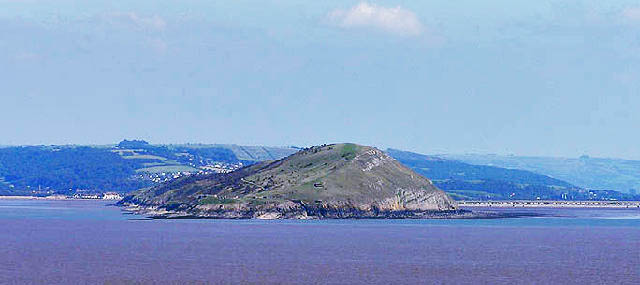
Weston Bay from Brean Down
Looking north from Brean Down
Brean Down steps Approaching Brean Down from the car park below
Brean Down steps
Approaching Brean Down from the car park below
Steep Holm[e] from Brean Down Boggy, yucky Severn mud looks golden black in the sunlight.
Steep Holm[e] from Brean Down
Boggy, yucky Severn mud looks golden black in the sunlight.
A windy Day on Brean Down. Looking out towards Steep Holm (left) Flat Holm (right) and Wales on the horizon.
A windy Day on Brean Down.
Looking out towards Steep Holm (left) Flat Holm (right) and Wales on the horizon.
Sand yachts on Brean Sands
Brean Down from Steepholm
Brean Down Fort One of the forts built in the 1860's in the Bristol Channel, to protect the coast from Napoleon. <span class="nowrap"><a title="http://www.burnham-on-sea.com/breandown.shtml" rel="nofollow ugc noopener" href="http://www.burnham-on-sea.com/breandown.shtml">Link</a><img style="margin-left:2px;" alt="External link" title="External link - shift click to open in new window" src="https://s1.geograph.org.uk/img/external.png" width="10" height="10"/></span>
Brean Down Fort
One of the forts built in the 1860's in the Bristol Channel, to protect the coast from Napoleon. LinkExternal link
Brean Down Tropical Bird Garden Looking down on the Bird Garden from the Brean headland.
Brean Down Tropical Bird Garden
Looking down on the Bird Garden from the Brean headland.
Brean Down Trig Point Showing Steepholm & Flatholm in the distance.
Brean Down Trig Point
Showing Steepholm & Flatholm in the distance.
Brean Down Fort and Steep Holm The very end point of Brean Down, with the most seaward part of the disused Brean Down Fort. It was a cold blustery day.
Brean Down Fort and Steep Holm
The very end point of Brean Down, with the most seaward part of the disused Brean Down Fort. It was a cold blustery day.
A path with a view Brean Down is the promontory on the south of Weston Bay. Walks along it give wonderful views along the coast. Here, the flat mud of low tide can be seen in front of the promenade of Weston-super-Mare.
A path with a view
Brean Down is the promontory on the south of Weston Bay. Walks along it give wonderful views along the coast. Here, the flat mud of low tide can be seen in front of the promenade of Weston-super-Mare.
Brean Down car park Park here and start a wounderful circular walk around Brean Down.
Brean Down car park
Park here and start a wounderful circular walk around Brean Down.
View of Brean Down A view of the far end of the beach at Brean Down.
View of Brean Down
A view of the far end of the beach at Brean Down.
Master of the slopes One of the herd of about two dozen goats inhabiting the cliffs.
Master of the slopes
One of the herd of about two dozen goats inhabiting the cliffs.
Go no further The far point of Brean Down with a view of Steep Holm
Go no further
The far point of Brean Down with a view of Steep Holm
Beach at Brean A peaceful view of the beach at Brean and on to Berrow from Brean Down.
Beach at Brean
A peaceful view of the beach at Brean and on to Berrow from Brean Down.
Caravans at Brean Holiday caravans on a quiet October day
Caravans at Brean
Holiday caravans on a quiet October day
Show me another place!

Fiddler's Point is located at Grid Ref: ST2959 (Lat: 51.326867, Lng: -3.0199909)

Administrative County: Somerset

District: Sedgemoor

Police Authority: Avon and Somerset

What 3 Words

///rise.foresight.broke. Near Weston-super-Mare, Somerset

Nearby Locations

Fiddler's Point

Related Wikis

Brean Down

Brean Down is a promontory off the coast of Somerset, England, standing 318 feet (97 m) high and extending 1+1⁄2 miles (2.5 kilometres) into the Bristol...
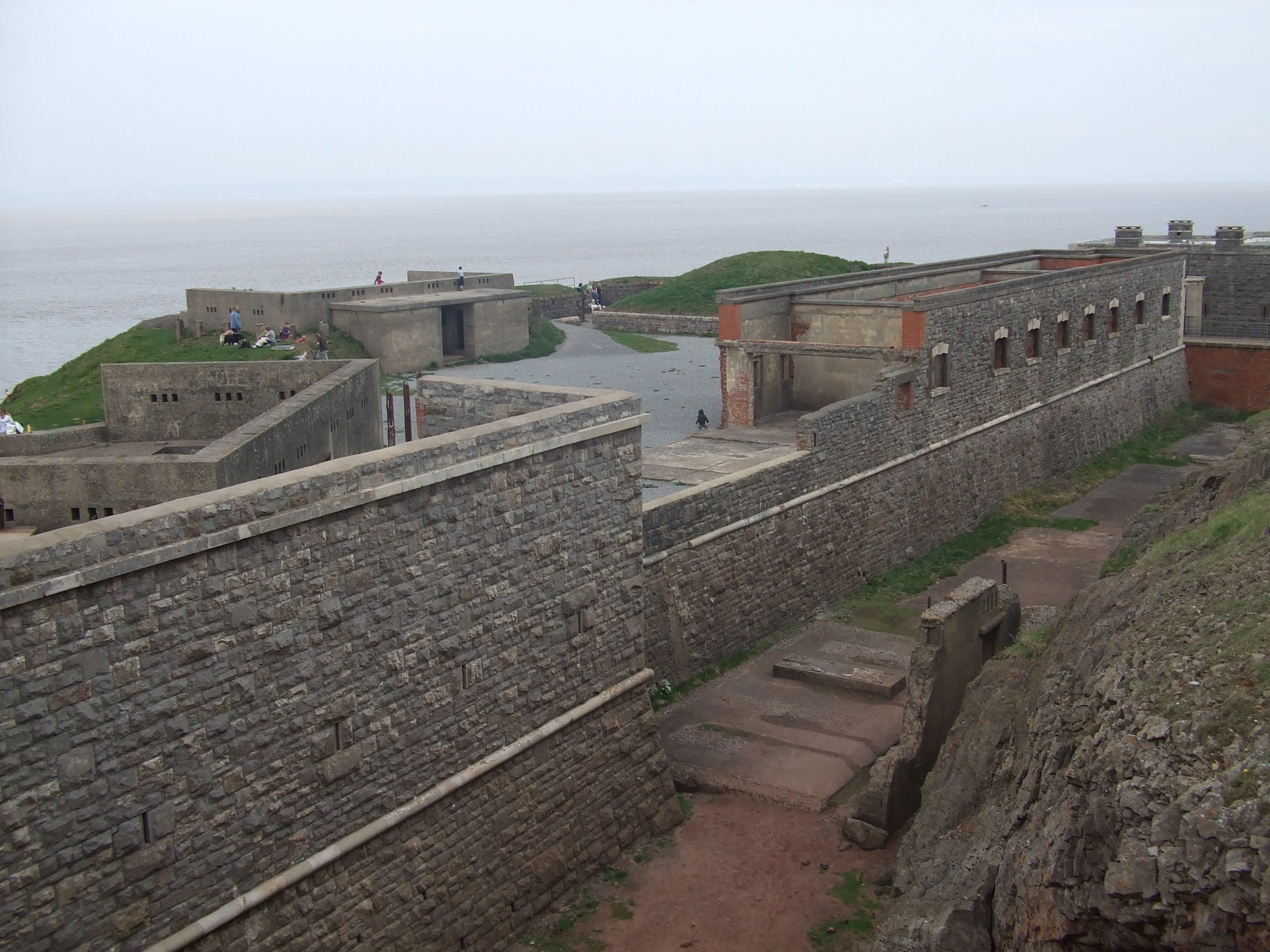
Brean Down Fort

Brean Down Fort was a Victorian naval fortification designed to protect the Bristol Channel. It was built 60 feet (18 m) above sea level on the headland...

Weston Bay

Weston Bay is an inlet of the Bristol Channel in North Somerset, England. It lies between Brean Down, which is now owned by the National Trust, is rich...

River Axe (Bristol Channel)

The River Axe is a river in South West England. The river is formed by water entering swallets in the limestone and rises from the ground at Wookey Hole...

Nearby Amenities

Located within 500m of 51.326867,-3.0199909
Source: PGS
Lat/Long: 51.3235788/-3.0241247
Source: PGS
Lat/Long: 51.3235415/-3.0216816
Source: PGS
Lat/Long: 51.3235347/-3.021196
Source: PGS
Lat/Long: 51.3234703/-3.0187748
Source: PGS
Lat/Long: 51.3232964/-3.016686
Ancient Field Systems
Access: yes
Archaeological Site: fortification
Historic: archaeological_site
Lat/Long: 51.3253183/-3.0265734
Fiddler's Bay Cave
Fee: no
Natural: cave_entrance
Lat/Long: 51.3270003/-3.0239914
Bench
Lat/Long: 51.3258675/-3.0210464
The data included in this document is from www.openstreetmap.org. The data is made available under ODbL.

Have you been to Fiddler's Point?

Leave your review of Fiddler's Point below (or comments, questions and feedback).