Jacob's Ladder

Coastal Feature, Headland, Point in Devon East Devon

England

Jacob's Ladder

Wall of Sidmouth's Victorian Jail (The Old Jail) A short stretch of wall with two windows with iron bars; all that remains of the jail; the blue plaque is at <a href="https://www.geograph.org.uk/photo/7692555">SY1287 : Blue plaque on wall of Sidmouth's Victorian jail</a>
Wall of Sidmouth's Victorian Jail (The Old Jail) Credit: David Smith

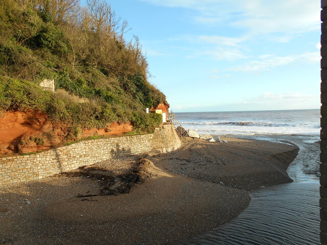
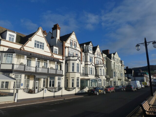
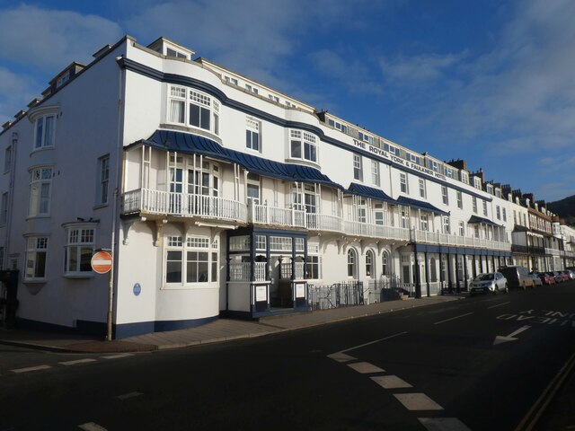
Jacob's Ladder, Devon, is a prominent coastal feature located on the southern coast of England, specifically in the town of Sidmouth. This headland, often referred to as a point, is a picturesque and popular tourist spot due to its dramatic cliffs, breathtaking views, and historical significance.

The name "Jacob's Ladder" is derived from the series of steps that have been carved into the steep cliffs, allowing visitors to access the beach below. These steps were originally constructed in the early 19th century by local fisherman, providing them with a safer method of reaching the shore. Today, the steps not only serve as a practical means of access but also add to the charm and character of this coastal feature.

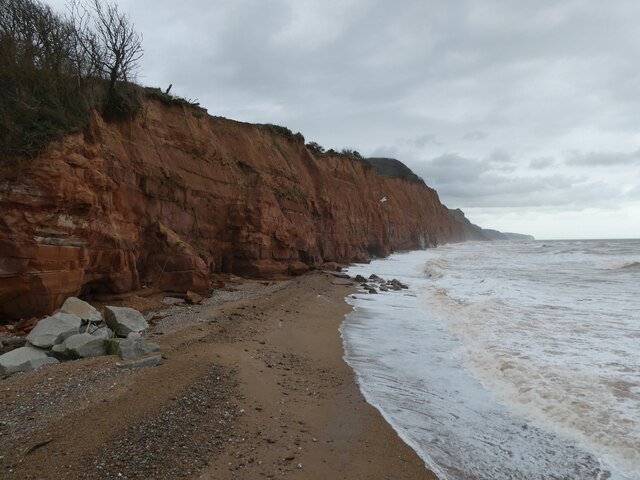
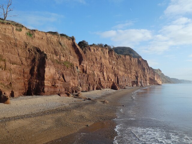
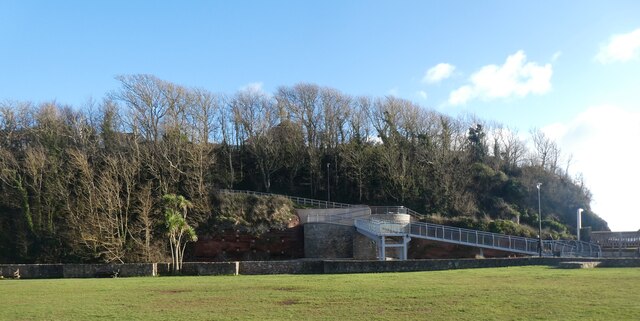
The headland itself is composed of stunning red sandstone cliffs that rise dramatically from the sea, reaching heights of approximately 100 feet. These cliffs offer visitors unparalleled views of the English Channel, with panoramic vistas stretching as far as the eye can see. The rugged beauty of Jacob's Ladder, combined with the crashing waves below, creates a truly awe-inspiring experience for those who visit.

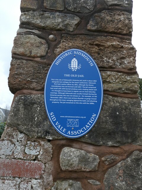
In addition to its natural beauty, Jacob's Ladder also holds historical significance. The headland was once home to a defensive fortification known as Jacob's Ladder Fort. Built in the early 19th century as a response to the threat of invasion, the fort played a crucial role in protecting the area during times of conflict.

Overall, Jacob's Ladder in Devon is a stunning coastal feature that offers visitors a blend of natural beauty, historical significance, and breathtaking views. Whether one is interested in exploring the steps, admiring the cliffs, or learning about its historical past, this headland is a must-visit destination for anyone traveling to the southern coast of England.

If you have any feedback on the listing, please let us know in the comments section below.

Jacob's Ladder Images

Images are sourced within 2km of 50.674873/-3.2473608 or Grid Reference SY1186. Thanks to Geograph Open Source API. All images are credited.

Wall of Sidmouth's Victorian Jail (The Old Jail) A short stretch of wall with two windows with iron bars; all that remains of the jail; the blue plaque is at <a href="https://www.geograph.org.uk/photo/7692555">SY1287 : Blue plaque on wall of Sidmouth's Victorian jail</a>
Wall of Sidmouth's Victorian Jail (The Old Jail)
A short stretch of wall with two windows with iron bars; all that remains of the jail; the blue plaque is at SY1287 : Blue plaque on wall of Sidmouth's Victorian jail
Blue plaque on wall of Sidmouth's Victorian jail The side wall (all that remains) is at <a href="https://www.geograph.org.uk/photo/7692552">SY1287 : Wall of Sidmouth's Victorian Jail (The Old Jail)</a>
Blue plaque on wall of Sidmouth's Victorian jail
The side wall (all that remains) is at SY1287 : Wall of Sidmouth's Victorian Jail (The Old Jail)
Stormy sea, cliffs and cliff falls, east of Sidmouth
Stormy sea on Sidmouth beach
Boundary Stone, Peak Hill Boundary between Sidmouth and Otterton, on the verge. The image at the top is of an otter; they can be seen on the River Otter nearer the sea. There is also an older Boundary Stone on Peak Hill with "SP" inscribed - see <a title="https://www.geograph.org.uk/photo/6094772" href="https://www.geograph.org.uk/photo/6094772">Link</a>

Inscription: Parish / of / Otterton / 2000

Milestone Society National ID: DV_ELOT08cm
Boundary Stone, Peak Hill
Boundary between Sidmouth and Otterton, on the verge. The image at the top is of an otter; they can be seen on the River Otter nearer the sea. There is also an older Boundary Stone on Peak Hill with "SP" inscribed - see Link Inscription: Parish / of / Otterton / 2000 Milestone Society National ID: DV_ELOT08cm
Walking the dog Approaching Alma bridge from Cliff road.
An earlier footpath ran straight on. This has now fallen into the sea and the path diverted to its new course.
Walking the dog
Approaching Alma bridge from Cliff road. An earlier footpath ran straight on. This has now fallen into the sea and the path diverted to its new course.
Looking up river A view up the River Sid off the new Alma bridge.
The old bridge was replaced due to coastal erosion
Looking up river
A view up the River Sid off the new Alma bridge. The old bridge was replaced due to coastal erosion
An everchanging view The mouth of the River Sid.
the shingle banks continue to move due to either tidal or river actions.
An everchanging view
The mouth of the River Sid. the shingle banks continue to move due to either tidal or river actions.
Lawn Vista allotments Basking in the January sunshine. There are occasions when the nearby River Sid floods and these are then underwater.
The railings belong from a pre health and safety era and still retain spikes.
Note the novel way of resolving this.
Lawn Vista allotments
Basking in the January sunshine. There are occasions when the nearby River Sid floods and these are then underwater. The railings belong from a pre health and safety era and still retain spikes. Note the novel way of resolving this.
A long wall the wall originally enclosed the gardens to Sidmouth convent.
It is now a private school. Part of which can be seen in the distance.
A long wall
the wall originally enclosed the gardens to Sidmouth convent. It is now a private school. Part of which can be seen in the distance.
Lymebourne Avenue Two rows of Edwardian terraced houses.
Lymebourne Avenue
Two rows of Edwardian terraced houses.
Alma Lane Named after a battle in the Crimean offensive.1853 - 1856.
Alma Lane
Named after a battle in the Crimean offensive.1853 - 1856.
Kingswood and Devoran Hotels, Sidmouth
Royal York and Faulkner Hotel, Sidmouth
Salcombe Hill Cliff, east of Sidmouth The same view as in <a href="https://www.geograph.org.uk/photo/6697279">SY1387 : Salcombe Hill Cliff, east of Sidmouth</a> but 13 months later.  Yet more cliff falls and erosion of the cliff
Salcombe Hill Cliff, east of Sidmouth
The same view as in SY1387 : Salcombe Hill Cliff, east of Sidmouth but 13 months later. Yet more cliff falls and erosion of the cliff
Playing field, between Sidmouth Swimming Pool and River Sid
Bare trees in The Byes, Sidmouth
Alma Bridge over River Sid, Sidmouth
Show me another place!

Jacob's Ladder is located at Grid Ref: SY1186 (Lat: 50.674873, Lng: -3.2473608)

Administrative County: Devon

District: East Devon

Police Authority: Devon and Cornwall

What 3 Words

///expose.trail.called. Near Sidmouth, Devon

Nearby Locations

Jacob's Ladder Cliff Field

Related Wikis

Peak House, Sidmouth

Peak House in Sidmouth, Devon, is a building designed by Evelyn Hellicar. It was finished in 1904 and is entirely made of beer stone. It is a Grade II...

Kennaway House

Kennaway House is a Regency town house in Sidmouth, East Devon, which was formerly known as Fort House and Church House. It is a Grade II* listed building...

Sidmouth Museum

Sidmouth Museum is a museum in Sidmouth, Devon, England. The museum is housed in Hope Cottage, a Grade II listed building. The building was extended in...

East Devon

East Devon is a local government district in Devon, England. Its council is based in the town of Honiton, although Exmouth is the largest town. The district...

Nearby Amenities

Located within 500m of 50.674873,-3.2473608
Source: PGS
Lat/Long: 50.6739732/-3.2529123
Source: PGS
Lat/Long: 50.6743792/-3.2500897
Source: PGS
Lat/Long: 50.6744269/-3.2498106
Source: PGS
Lat/Long: 50.6745756/-3.2490433
Source: PGS
Lat/Long: 50.6747707/-3.2475834
Source: PGS
Lat/Long: 50.6747171/-3.2471931
Source: PGS
Lat/Long: 50.6753874/-3.244702
Source: PGS
Lat/Long: 50.6756707/-3.2442373
Source: PGS
Lat/Long: 50.6761866/-3.2426099
Source: PGS
Lat/Long: 50.6764539/-3.2417386
Source: PGS
Lat/Long: 50.6768322/-3.2410053
Toilets
Check Date: 2022-08-06
Fee: no
Wheelchair: limited
Lat/Long: 50.6758568/-3.2466958
Telephone
Booth: KX100
Check Date: 2024-04-01
Covered: booth
Note: missing handset today
Operator: BT
Operator Wikidata: Q593786
Phone: +44 1395 514887
Lat/Long: 50.6758643/-3.2465372
Post Box
Collection Times: Mo-Fr 09:00; Sa 07:00
Operator: Royal Mail
Operator Wikidata: Q638098
Post Box Mounting: brick_wall
Post Box Type: wall
Ref: EX10 72D
Royal Cypher: EIIR
Royal Cypher Wikidata: Q33102113
Lat/Long: 50.6788391/-3.2489491
Cafe
Connaught Gardens Café
Check Date: 2023-04-17
Lat/Long: 50.6752864/-3.2465027
Belmont Hotel
Addr City: Sidmouth
Addr Postcode: EX10 8RX
Addr Street: The Esplanade
Contact Facebook: The.Belmont.Hotel.4.star
Contact Instagram: thebelmontbrend
Contact Twitter: TheBelmontBrend
Fhrs Id: 167746
Phone: +44 1395 512555
Tourism: hotel
Website: https://belmont-hotel.co.uk
Lat/Long: 50.6774255/-3.2432075
Victoria Hotel
Addr City: Sidmouth
Addr Postcode: EX10 8RY
Addr Street: The Esplanade
Contact Facebook: The.Victoria.Hotel.4.star
Contact Instagram: victoriahotelsidmouth
Contact Twitter: Victoriabrends
Fhrs Id: 167539
Phone: +44 1395 512651
Tourism: hotel
Website: https://victoriahotel.co.uk
Lat/Long: 50.6770068/-3.2442267
Chit Rocks
Natural: rocks
Lat/Long: 50.6741219/-3.2450501
Post Box
Collection Times: Mo-Fr 09:00; Sa 07:00
Operator: Royal Mail
Operator Wikidata: Q638098
Post Box Type: pillar
Ref: EX10 83D
Royal Cypher: EVIIR
Royal Cypher Wikidata: Q33102324
Lat/Long: 50.6775689/-3.2466649
Turning Circle
Lat/Long: 50.677235/-3.2532262
Bench
Backrest: yes
Lat/Long: 50.6753278/-3.2521842
Seamark Light Character: Fl
Seamark Light Colour: red
Seamark Light Height: 5
Seamark Light Period: 5
Seamark Light Range: 2
Seamark Light Reference: A 0278
Seamark Type: light_minor
Source: US NGA Pub. 114. 2011-05-26.
Lat/Long: 50.6748678/-3.2405322
Barrier: bollard
Lat/Long: 50.6758928/-3.2472258
Bench
Backrest: yes
Lat/Long: 50.6754/-3.2508175
Historic: memorial
Memorial: plaque
Lat/Long: 50.6782862/-3.2427936
Rock House
Historic: memorial
Memorial: plaque
Lat/Long: 50.6765847/-3.2436867
Historic: memorial
Memorial: plaque
Lat/Long: 50.6767692/-3.243283
Historic: memorial
Memorial: plaque
Lat/Long: 50.6757943/-3.247077
Historic: memorial
Memorial: plaque
Lat/Long: 50.6755683/-3.2461142
Historic: memorial
Memorial: plaque
Lat/Long: 50.6753158/-3.2463326
Post Box
Collection Times: Mo-Fr 09:00; Sa 07:00
Ref: EX10 84D
Royal Cypher: GR
Royal Cypher Wikidata: Q33102273
Lat/Long: 50.6753039/-3.253176
Old Fort,Belmont
Historic: memorial
Memorial: plaque
Lat/Long: 50.677104/-3.2423188
Royal Glen Hotel
Tourism: hotel
Wikidata: Q17525823
Lat/Long: 50.6780793/-3.2444412
Sidmouth Harbour Hotel
Addr City: Sidmouth
Addr Postcode: EX10 8RU
Addr Street: Manor Road
Contact Facebook: sidmouthharbourhotel
Contact Instagram: sidmouthharbourhotel
Fhrs Id: 167404
Phone: +44 1395 513252
Tourism: hotel
Website: https://www.harbourhotels.co.uk/sidmouth
Lat/Long: 50.6765554/-3.2453337
Barrier: bollard
Bollard: fixed
Lat/Long: 50.6776669/-3.2470903
Bench
Backrest: yes
Lat/Long: 50.6757506/-3.2478304
Bench
Backrest: yes
Lat/Long: 50.6749584/-3.2536724
Bench
Backrest: yes
Survey Date: 2023-03-18
Lat/Long: 50.675827/-3.2481276
Barrier: kissing_gate
Lat/Long: 50.6748963/-3.2538807
Bicycle Parking
Bicycle Parking: stands
Capacity: 8
Lat/Long: 50.677318/-3.2415113
Jacobs Ladder
Historic: monument
Lat/Long: 50.6752909/-3.2468473
Direction: 100
Generator Method: photovoltaic
Generator Output Electricity: yes
Generator Solar Modules: 14
Generator Source: solar
Generator Type: solar_photovoltaic_panel
Location: roof
Power: generator
Lat/Long: 50.6761843/-3.2532299
Direction: 190
Generator Method: photovoltaic
Generator Output Electricity: yes
Generator Solar Modules: 5
Generator Source: solar
Generator Type: solar_photovoltaic_panel
Location: roof
Power: generator
Lat/Long: 50.6789259/-3.2496974
Direction: SE
Generator Method: photovoltaic
Generator Output Electricity: yes
Generator Solar Modules: 6
Generator Source: solar
Generator Type: solar_photovoltaic_panel
Location: roof
Power: generator
Lat/Long: 50.678331/-3.2499442
Direction: 195
Generator Method: photovoltaic
Generator Output Electricity: yes
Generator Solar Modules: 14
Generator Source: solar
Generator Type: solar_photovoltaic_panel
Location: roof
Power: generator
Lat/Long: 50.6775458/-3.247219
Direction: 175
Generator Method: photovoltaic
Generator Output Electricity: yes
Generator Solar Modules: 8
Generator Source: solar
Generator Type: solar_photovoltaic_panel
Location: roof
Power: generator
Lat/Long: 50.6782715/-3.2479338
Direction: 175
Generator Method: photovoltaic
Generator Output Electricity: yes
Generator Solar Modules: 6
Generator Source: solar
Generator Type: solar_photovoltaic_panel
Location: roof
Power: generator
Lat/Long: 50.6783208/-3.2479432
Barrier: chain
Lat/Long: 50.6761087/-3.2469885
Bench
Backrest: yes
Survey Date: 2023-03-18
Lat/Long: 50.6750546/-3.2538038
Bench
Backrest: yes
Survey Date: 2023-03-18
Lat/Long: 50.6754282/-3.2515484
Bench
Survey Date: 2023-03-18
Lat/Long: 50.6756993/-3.2478451
Bench
Survey Date: 2023-03-18
Lat/Long: 50.6757395/-3.2476959
Bench
Backrest: yes
Survey Date: 2023-03-18
Lat/Long: 50.6757271/-3.2477219
Bench
Backrest: yes
Survey Date: 2023-03-18
Lat/Long: 50.6750595/-3.2533907
Bench
Backrest: yes
Survey Date: 2023-03-18
Lat/Long: 50.6751064/-3.2532865
Bench
Backrest: yes
Survey Date: 2023-03-18
Lat/Long: 50.6751821/-3.2529006
Bench
Backrest: yes
Survey Date: 2023-03-18
Lat/Long: 50.6754275/-3.2513904
Bench
Backrest: yes
Survey Date: 2023-03-18
Lat/Long: 50.6757256/-3.2480082
Waste Basket
Survey Date: 2023-03-18
Lat/Long: 50.675455/-3.2472281
Waste Basket
Survey Date: 2023-03-18
Lat/Long: 50.6754742/-3.2472775
Life Ring
Emergency: life_ring
Survey Date: 2023-03-18
Lat/Long: 50.6764877/-3.2433308
Waste Basket
Survey Date: 2023-03-18
Lat/Long: 50.6768103/-3.2425128
Waste Basket
Survey Date: 2023-03-18
Lat/Long: 50.6768285/-3.2424615
Bench
Backrest: yes
Survey Date: 2023-03-18
Lat/Long: 50.6751376/-3.2532431
Bench
Backrest: yes
Survey Date: 2023-03-18
Lat/Long: 50.675217/-3.2528236
Bench
Backrest: yes
Survey Date: 2023-03-18
Lat/Long: 50.6752886/-3.2524642
Bench
Backrest: yes
Survey Date: 2023-03-18
Lat/Long: 50.6753442/-3.2519823
Bench
Backrest: yes
Survey Date: 2023-03-18
Lat/Long: 50.675366/-3.2517877
Bench
Backrest: yes
Survey Date: 2023-03-18
Lat/Long: 50.6754698/-3.2511819
Life Ring
Emergency: life_ring
Survey Date: 2023-03-18
Lat/Long: 50.6754933/-3.2472935
Life Ring
Emergency: life_ring
Survey Date: 2023-03-18
Lat/Long: 50.6753018/-3.2468635
Life Ring
Emergency: life_ring
Survey Date: 2023-03-18
Lat/Long: 50.6768692/-3.2423055
Life Ring
Emergency: life_ring
Survey Date: 2023-03-18
Lat/Long: 50.6771941/-3.2415488
Bench
Backrest: yes
Survey Date: 2023-03-18
Lat/Long: 50.6769102/-3.2423176
Waste Basket
Survey Date: 2023-03-18
Lat/Long: 50.6770865/-3.2419345
Bench
Backrest: yes
Survey Date: 2023-03-18
Lat/Long: 50.6771213/-3.2418334
Bench
Backrest: yes
Survey Date: 2023-03-18
Lat/Long: 50.6771583/-3.2417376
Bench
Backrest: yes
Survey Date: 2023-03-18
Lat/Long: 50.678621/-3.2486338
Bench
Backrest: yes
Survey Date: 2023-03-18
Lat/Long: 50.6752925/-3.2526432
Bench
Survey Date: 2023-03-18
Lat/Long: 50.6756247/-3.2477787
Recycling
Recycling Type: container
Survey Date: 2023-03-18
Lat/Long: 50.6768147/-3.2424821
Waste Basket
Survey Date: 2023-03-18
Lat/Long: 50.6770984/-3.2419121
Bench
Backrest: yes
Survey Date: 2023-03-18
Lat/Long: 50.6772479/-3.2414786
Bench
Backrest: yes
Survey Date: 2023-03-18
Lat/Long: 50.6785636/-3.2491017
Bench
Backrest: yes
Survey Date: 2023-03-18
Lat/Long: 50.6749904/-3.2535631
Waste Basket
Survey Date: 2023-03-18
Waste: dog_excrement
Lat/Long: 50.6758231/-3.2482032
Bench
Survey Date: 2023-03-18
Lat/Long: 50.6756528/-3.2478144
Bench
Survey Date: 2023-03-18
Lat/Long: 50.6755766/-3.2477105
Bench
Backrest: yes
Survey Date: 2023-03-18
Lat/Long: 50.6766903/-3.2427473
Bench
Survey Date: 2023-03-18
Lat/Long: 50.675724/-3.2478417
Bench
Survey Date: 2023-03-18
Lat/Long: 50.6756719/-3.2478377
Bench
Survey Date: 2023-03-18
Lat/Long: 50.6756094/-3.2477474
Bench
Backrest: yes
Survey Date: 2023-03-18
Lat/Long: 50.6767337/-3.242648
The data included in this document is from www.openstreetmap.org. The data is made available under ODbL.

Have you been to Jacob's Ladder?

Leave your review of Jacob's Ladder below (or comments, questions and feedback).