Craiglebbock Rocks

Coastal Feature, Headland, Point in Kirkcudbrightshire

Scotland

Craiglebbock Rocks

River Nith Estuary from Summit of Criffell March 2022 The Nith estuary is a tributary of the Solway Firth, overlooked by the prominent distinctive hill, Criffell.  The estuary dries at low tide, leaving a narrow river channel, and exposing the extensive Blackshaw Bank - a favoured feeding ground for waders and waterfowl. In the middle ground, just at the foot of Criffell, lies Loch Kindar.  The ruined Kirk Kindar stands on a small islet.
River Nith Estuary from Summit of Criffell March 2022 Credit: Graham Ovens

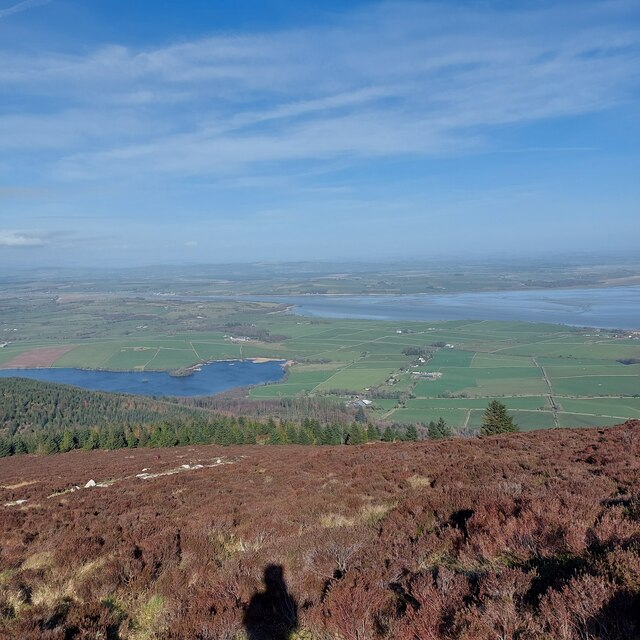
Craiglebbock Rocks is a prominent coastal feature located in the region of Kirkcudbrightshire, Scotland. Situated along the rugged coastline, this headland juts out into the North Channel of the Irish Sea, making it a noteworthy point of interest for both locals and visitors.

The rocks themselves are composed of a rugged and weathered material, creating a distinctive and picturesque landscape. They have been shaped over centuries by the relentless pounding of the waves, resulting in a series of impressive rock formations and sea stacks. These formations provide a haven for various seabirds, adding to the area's natural beauty.

Access to Craiglebbock Rocks is relatively easy, with a well-maintained footpath leading to the headland. From this vantage point, visitors are treated to breathtaking views of the surrounding coastal scenery, with the rocky cliffs and crashing waves creating a dramatic backdrop. On clear days, the Isle of Man can be seen in the distance, further enhancing the allure of this coastal feature.

Due to its location, Craiglebbock Rocks is subjected to the full force of the Atlantic Ocean, resulting in a dynamic and ever-changing environment. It is advisable for visitors to exercise caution and stay a safe distance from the edges, as the powerful waves can pose a risk. Nonetheless, the rocks offer a unique opportunity to witness the raw power of nature and appreciate the stunning coastal landscape that defines this area of Kirkcudbrightshire.

If you have any feedback on the listing, please let us know in the comments section below.

Craiglebbock Rocks Images

Images are sourced within 2km of 54.959352/-3.5780941 or Grid Reference NX9963. Thanks to Geograph Open Source API. All images are credited.

River Nith Estuary from Summit of Criffell March 2022 The Nith estuary is a tributary of the Solway Firth, overlooked by the prominent distinctive hill, Criffell.  The estuary dries at low tide, leaving a narrow river channel, and exposing the extensive Blackshaw Bank - a favoured feeding ground for waders and waterfowl. In the middle ground, just at the foot of Criffell, lies Loch Kindar.  The ruined Kirk Kindar stands on a small islet.
River Nith Estuary from Summit of Criffell March 2022
The Nith estuary is a tributary of the Solway Firth, overlooked by the prominent distinctive hill, Criffell. The estuary dries at low tide, leaving a narrow river channel, and exposing the extensive Blackshaw Bank - a favoured feeding ground for waders and waterfowl. In the middle ground, just at the foot of Criffell, lies Loch Kindar. The ruined Kirk Kindar stands on a small islet.
Drumburn Viewpoint, Nith Estuary: Blackshaw Bank
Overton: Looking towards Drum Bay
The Nith Estuary from near Castle Douglas Looking east over Criffel into the early morning sun, over the wide estuary and the entry of the Lochar Water beyond; beyond that the head of the Solway Firth. The patch of water, to the left of the small patch of cloud on Criffel, is Loch Kindar just south of New Abbey.
The Nith Estuary from near Castle Douglas
Looking east over Criffel into the early morning sun, over the wide estuary and the entry of the Lochar Water beyond; beyond that the head of the Solway Firth. The patch of water, to the left of the small patch of cloud on Criffel, is Loch Kindar just south of New Abbey.
Airds Merse Beside the River Nith.
Airds Merse
Beside the River Nith.
River Nith at mouth of New Abbey Pow burn
Burnfoot Cottage
Burnfoot Cottage
Coastline at the estuary of the River Nith at Craiglebbock Rocks
Structure in a field below Overton Farm at the estuary of the River Nith Maybe an old WW2 building or Civil Defence
Structure in a field below Overton Farm at the estuary of the River Nith
Maybe an old WW2 building or Civil Defence
Farmland and hedgerow below Overton Farm
Neglected bungalow at Burnfoot
View to Overton Cottages From the dead end lane that leads to Burnfoot.
View to Overton Cottages
From the dead end lane that leads to Burnfoot.
Bus shelter near Overton On the A710 opposite the lane that leads to the hamlet of Overton. Also spotted by Debbie Turner in 2007. See <a title="https://www.geograph.org.uk/photo/609980" href="https://www.geograph.org.uk/photo/609980">Link</a>
Bus shelter near Overton
On the A710 opposite the lane that leads to the hamlet of Overton. Also spotted by Debbie Turner in 2007. See Link
Knockendoch View Knockendoch is an outlier of Criffel, which can be accessed from a path at the end of this road.
Knockendoch View
Knockendoch is an outlier of Criffel, which can be accessed from a path at the end of this road.
Loch Kindar View Viewed from farmland on the Ardwall access road, the islands lie in the next square. The smaller island is a crannog. There's an old church tucked away on the other island. The far-off Waterloo Monument is just visible on the skyline.
Loch Kindar View
Viewed from farmland on the Ardwall access road, the islands lie in the next square. The smaller island is a crannog. There's an old church tucked away on the other island. The far-off Waterloo Monument is just visible on the skyline.
Towards Knockendoch Looking over farmland towards Loch Kindar and the slopes of Knockendoch on a lovely early-October afternoon.
Towards Knockendoch
Looking over farmland towards Loch Kindar and the slopes of Knockendoch on a lovely early-October afternoon.
Old Milestone by the A710, Overton, New Abbey Parish By the A710, in parish of New Abbey (Nithsdale District), Overton.

Inscription once read:- : (Dumfries / 9) :

Surveyed

Milestone Society National ID: DG_DFDBS09.
Old Milestone by the A710, Overton, New Abbey Parish
By the A710, in parish of New Abbey (Nithsdale District), Overton. Inscription once read:- : (Dumfries / 9) : Surveyed Milestone Society National ID: DG_DFDBS09.
Towards Inglestonford from Ardwall Looking over Loch Kindar, across farmland, to the Nith Estuary. In the distance is Caerlaverock.
Towards Inglestonford from Ardwall
Looking over Loch Kindar, across farmland, to the Nith Estuary. In the distance is Caerlaverock.
Show me another place!

Craiglebbock Rocks is located at Grid Ref: NX9963 (Lat: 54.959352, Lng: -3.5780941)

Unitary Authority: Dumfries and Galloway

Police Authority: Dumfries and Galloway

What 3 Words

///nothing.kilt.decays. Near Dumfries, Dumfries & Galloway

Nearby Locations

Craiglebbock Rocks

Related Wikis

Abbey Vale F.C.

Abbey Vale Football Club are a football club based in the village of New Abbey in the historical county of Kirkcudbright shire in the Dumfries and Galloway...

Sweetheart Abbey

The Abbey of Dulce Cor, better known as Sweetheart Abbey (Gaelic: An Abaid Ur), was a Cistercian monastery founded in 1275 in what is now the village of...

New Abbey

New Abbey (Scottish Gaelic: An Abaid Ùr) is a village in the historical county of Kirkcudbrightshire in Dumfries and Galloway, Scotland. It is 6 miles...

Caerlaverock Castle

Caerlaverock Castle is a moated triangular castle first built in the 13th century. It is located on the southern coast of Scotland, eleven kilometres...

Criffel

Criffel is a hill in the historical county of Kirkcudbrightshire, Dumfries and Galloway, south-west Scotland. It is 570 m (1,870 ft) high but appears higher...

National Museum of Costume

The National Museum of Costume was located at Shambellie House, in New Abbey, Dumfries and Galloway, Scotland and it formed part of the National Museums...

River Nith

The River Nith (Scottish Gaelic: Abhainn Nid; Common Brittonic: Nowios) is a river in south-west Scotland. The Nith rises in the Carsphairn hills of East...

Caerlaverock

Caerlaverock (; Scottish Gaelic: Cille Bhlàthain) is a civil parish in Dumfries and Galloway, Scotland. The parish was historically in Dumfriesshire....

Nearby Amenities

Located within 500m of 54.959352,-3.5780941
Source: PGS
Lat/Long: 54.9554823/-3.5792866
Source: PGS
Lat/Long: 54.9565477/-3.5790669
Source: PGS
Lat/Long: 54.9581261/-3.5782886
Source: PGS
Lat/Long: 54.9590042/-3.5781432
Source: PGS
Lat/Long: 54.9599125/-3.5776785
Source: PGS
Lat/Long: 54.9600982/-3.5774952
Source: PGS
Lat/Long: 54.9603218/-3.5774509
Source: PGS
Lat/Long: 54.9607003/-3.5773921
Source: PGS
Lat/Long: 54.9611801/-3.5772641
Source: PGS
Lat/Long: 54.9616235/-3.577243
Source: PGS
Lat/Long: 54.9620902/-3.5777587
Source: PGS
Lat/Long: 54.9624715/-3.5780225
Source: PGS
Lat/Long: 54.9626247/-3.578346
Source: PGS
Lat/Long: 54.9631885/-3.5788578
Source: PGS
Lat/Long: 54.9637273/-3.5792721
Power: pole
Source: bing
Lat/Long: 54.9578703/-3.5850541
The data included in this document is from www.openstreetmap.org. The data is made available under ODbL.

Have you been to Craiglebbock Rocks?

Leave your review of Craiglebbock Rocks below (or comments, questions and feedback).