Beadnell

Settlement in Northumberland

England

Beadnell

Looking seaward over Annstead Rocks
Looking seaward over Annstead Rocks Credit: Richard Law

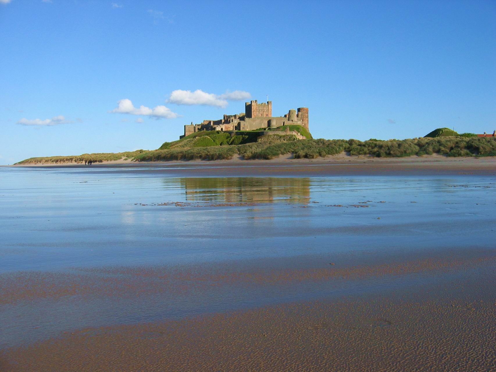
Beadnell is a small coastal village located in Northumberland, England. Situated on the North Sea coast, it lies approximately 4 miles south-east of the town of Bamburgh and 15 miles north-east of Alnwick.

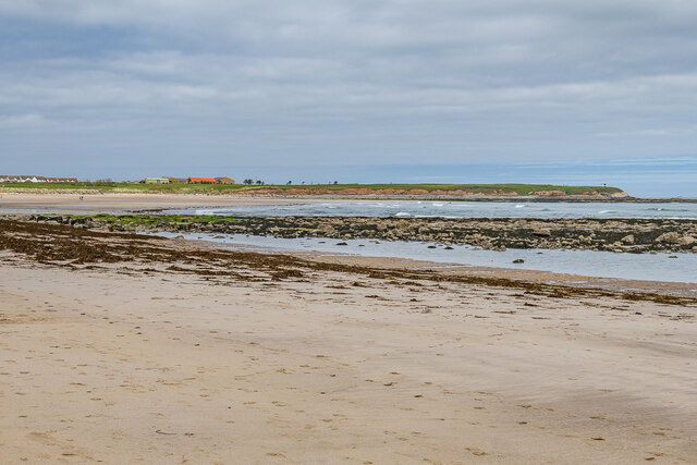
Known for its picturesque beauty, Beadnell boasts a stunning sandy beach that stretches for approximately two miles. This beach is a popular destination for tourists, offering opportunities for sunbathing, picnicking, and various water sports such as surfing, kayaking, and sailing. The village is also home to a small harbor, which provides a safe haven for local fishing boats and adds to the charm of the area.

Beadnell has a rich history, with evidence of settlements dating back to the Bronze Age. The village is home to several historic buildings, including the 18th-century lime kilns, which were once used to produce lime for agricultural purposes. The lime kilns now serve as a prominent landmark and a reminder of the village's industrial past.

In terms of amenities, Beadnell offers a range of facilities to cater to visitors' needs. There are several pubs, cafes, and restaurants where visitors can sample local cuisine and enjoy a relaxing meal. The village also has a selection of shops, including a convenience store, gift shops, and a surf shop.

Beadnell is a perfect destination for those seeking a peaceful coastal retreat. Its natural beauty, rich history, and range of activities make it an ideal place to visit for both locals and tourists alike.

If you have any feedback on the listing, please let us know in the comments section below.

Beadnell Images

Images are sourced within 2km of 55.556885/-1.636585 or Grid Reference NU2329. Thanks to Geograph Open Source API. All images are credited.

Looking seaward over Annstead Rocks
Along the beach towards Seahouses
Northwards from the edge of Annstead Rocks Shortly after the turn of tide on a bright September afternoon
Northwards from the edge of Annstead Rocks
Shortly after the turn of tide on a bright September afternoon
Northern tip of Annstead Rocks Much of the seaward part of the beach to the south of here consists of a low platform of limestone and sandstone outcrops. From this point north, that gives way to open sand until the low cliffs just below the golf course.
Northern tip of Annstead Rocks
Much of the seaward part of the beach to the south of here consists of a low platform of limestone and sandstone outcrops. From this point north, that gives way to open sand until the low cliffs just below the golf course.
Public footpath near Annstead On the path between Swinhoe and Annstead, with the Annstead Burn in the trees just on the left.
Public footpath near Annstead
On the path between Swinhoe and Annstead, with the Annstead Burn in the trees just on the left.
Cattle in a field near Annstead Farm Mostly Belted Galloways, which had run alongside me as I made my way up the path from Burnfield Plantation a little to the southwest.
Cattle in a field near Annstead Farm
Mostly Belted Galloways, which had run alongside me as I made my way up the path from Burnfield Plantation a little to the southwest.
Track towards Annstead Farm
Annstead Farm House This rather fine, extensive farmhouse was built around 1810, but may have parts that date back before that period. It retains a number of interior features of the early 19th century, and was Grade II listed <span class="nowrap"><a title="https://britishlistedbuildings.co.uk/101233048-annstead-housecottage-and-attached-outbuildings-beadnell#.YUTPorhKjIU" rel="nofollow ugc noopener" href="https://britishlistedbuildings.co.uk/101233048-annstead-housecottage-and-attached-outbuildings-beadnell#.YUTPorhKjIU">Link</a><img style="margin-left:2px;" alt="External link" title="External link - shift click to open in new window" src="https://s1.geograph.org.uk/img/external.png" width="10" height="10"/></span> & <span class="nowrap"><a title="https://historicengland.org.uk/listing/the-list/list-entry/1233048" rel="nofollow ugc noopener" href="https://historicengland.org.uk/listing/the-list/list-entry/1233048">Link</a><img style="margin-left:2px;" alt="External link" title="External link - shift click to open in new window" src="https://s1.geograph.org.uk/img/external.png" width="10" height="10"/></span> in 1952.
Annstead Farm House
This rather fine, extensive farmhouse was built around 1810, but may have parts that date back before that period. It retains a number of interior features of the early 19th century, and was Grade II listed LinkExternal link & LinkExternal link in 1952.
Looking out over Annstead Rocks at low tide The exposed rocks attract a lot of birdlife - cormorants, redshanks, curlews, lapwings, assorted smaller waders, herons etc.
Looking out over Annstead Rocks at low tide
The exposed rocks attract a lot of birdlife - cormorants, redshanks, curlews, lapwings, assorted smaller waders, herons etc.
All the space they could want An open, clean beach with few or no restrictions on dogs just to the south of Seahouses. Northumberland's rubbish, don't go there!
All the space they could want
An open, clean beach with few or no restrictions on dogs just to the south of Seahouses. Northumberland's rubbish, don't go there!
Annstead Beach Looking north along Annstead Beach towards North Sunderland Point, with the start of Annstead Rocks on the right.
Annstead Beach
Looking north along Annstead Beach towards North Sunderland Point, with the start of Annstead Rocks on the right.
Annstead Beach Looking north along Annstead Beach towards North Sunderland Point, with Annstead Rocks off shore.
Annstead Beach
Looking north along Annstead Beach towards North Sunderland Point, with Annstead Rocks off shore.
Annstead Beach Looking north along Annstead Beach towards North Sunderland Point, with Annstead Rocks off shore.
Annstead Beach
Looking north along Annstead Beach towards North Sunderland Point, with Annstead Rocks off shore.
Annstead Beach Looking down on Annstead Beach with Annstead Rocks off shore.
Annstead Beach
Looking down on Annstead Beach with Annstead Rocks off shore.
Rock platform Rock platform on the beach north of Beadnell.  In the distance is North Sunderland Point.
Rock platform
Rock platform on the beach north of Beadnell. In the distance is North Sunderland Point.
Rock platform Rock platform on the beach north of Beadnell.
Rock platform
Rock platform on the beach north of Beadnell.
Rock platform Rock platform on the beach north of Beadnell.  In the distance is North Sunderland Point.
Rock platform
Rock platform on the beach north of Beadnell. In the distance is North Sunderland Point.
Rock platform Rock platform on the beach north of Beadnell.  In the distance is North Sunderland Point.
Rock platform
Rock platform on the beach north of Beadnell. In the distance is North Sunderland Point.
Show me another place!

Beadnell is located at Grid Ref: NU2329 (Lat: 55.556885, Lng: -1.636585)

Unitary Authority: Northumberland

Police Authority: Northumbria

What 3 Words

///dubbing.towels.stormed. Near Beadnell, Northumberland

Related Wikis

Beadnell

Beadnell is a village and civil parish in Northumberland, England. It is situated about 4 miles (6.4 km) south-east of Bamburgh, on the North Sea coast...

Benthall, Northumberland

Benthall is a village in Northumberland, England. It is about 6 kilometres (4 mi) south east of Bamburgh, on the North Sea coast, and 1 kilometre (⅔ mi...

North Sunderland

North Sunderland is a fishing village on the coast of Northumberland, England, and adjacent to Seahouses. The population of the civil parish was 1,803...

Seahouses railway station

Seahouses railway station was the brick and wood built eastern terminus of the single track branch of the North Sunderland Railway, in north east England...

North Sunderland railway station

North Sunderland railway station was a brick built station on the single track branch of the North Sunderland Railway, in north east England. The line...

Seahouses

Seahouses is a large village on the North Northumberland coast in England. It is about 20 kilometres (12 mi) north of Alnwick, within the Northumberland...

West Fleetham

West Fleetham is a small hamlet in Northumberland, England situated about 4 miles from Seahouses and 2 miles from Chathill railway station. It originally...

Northumberland Coast

The Northumberland Coast is a designated Area of Outstanding Natural Beauty (AONB) covering 40 miles (64 km) of coastline from Berwick-Upon-Tweed to the...

Nearby Amenities

Located within 500m of 55.556885,-1.636585
Beadnell
Place: village
Wikidata: Q2689370
Wikipedia: en:Beadnell
Lat/Long: 55.5568858/-1.636858
Bus: yes
Public Transport: stop_position
Lat/Long: 55.558071/-1.6341546
Power: pole
Lat/Long: 55.5545601/-1.6369905
Power: pole
Lat/Long: 55.5547687/-1.6363669
Power: pole
Lat/Long: 55.553587/-1.6419393
Power: pole
Lat/Long: 55.5536369/-1.6406697
Power: pole
Lat/Long: 55.5553081/-1.6347457
Power: pole
Lat/Long: 55.5556905/-1.6336075
Power: pole
Lat/Long: 55.5537983/-1.6392814
Power: pole
Lat/Long: 55.5541669/-1.6381455
Beadnell Green
Place: locality
Lat/Long: 55.5536251/-1.6372376
Material: wood
Power: pole
Lat/Long: 55.5581041/-1.6411347
Material: wood
Power: pole
Lat/Long: 55.5585709/-1.6420487
Material: wood
Power: pole
Lat/Long: 55.5590168/-1.6430009
Barrier: lift_gate
Lift Gate Type: double
Lat/Long: 55.5609625/-1.6362428
Parking
Fee: no
Park Ride: no
Parking: lane
Supervised: no
Lat/Long: 55.5592462/-1.6338776
Bus Stop
Bench: no
Bin: yes
Covered: yes
Departures Board: timetable
Naptan AtcoCode: 3100U232294
Naptan NaptanCode: nldajwmd
Shelter: yes
Lat/Long: 55.5585233/-1.6338305
Waste Basket
Lat/Long: 55.558562/-1.6337885
Bus Stop
Beadnell, The Haven
Bench: no
Covered: no
Shelter: no
Lat/Long: 55.5580609/-1.6340943
Beadnell Towers
Addr City: Beadnell
Addr County: Northumberland
Addr Postcode: NE67 5AY
Addr Street: The Wynding
Fhrs Id: 286870
Phone: +44 1665 721211
Tourism: hotel
Website: https://www.beadnelltowers.co.uk/
Wikidata: Q26526787
Lat/Long: 55.5561604/-1.6377852
Restaurant
The Towers
Addr City: Beadnell
Addr Street: The Wynding
Lat/Long: 55.5562272/-1.6378924
Bus Stop
Bench: no
Covered: no
Shelter: no
Lat/Long: 55.5565205/-1.637822
Restaurant
Salt Water Cafe
Addr City: Beadnell
Addr County: Northumberland
Addr Housenumber: 1-2
Addr Postcode: NE67 5AS
Addr Street: Church Cottages
Check Date: 2022-05-15
Fhrs Id: 943818
Payment Mastercard: yes
Payment Visa: yes
Lat/Long: 55.5565155/-1.6376556
Waste Basket
Lat/Long: 55.5565413/-1.637695
Post Box
Ref: NE67 103
Lat/Long: 55.5565223/-1.6377533
Post Office
Beadnell Mobile Post Office Service
Addr City: Chathill
Addr Postcode: NE67 5AN
Addr Street: Harbour Road
Addr Village: Beadnell
Note: Mobile Post Office
Opening Hours: We 15:00-16:30; Fr 12:30-14:00
Ref Pol Id: 119215
Lat/Long: 55.558826/-1.6331366
Post Box
Brand: Royal Mail
Brand Wikidata: Q638098
Drive Through: no
Operator: Royal Mail
Operator Wikidata: Q638098
Post Box Type: lamp
Ref: NE67 116
Lat/Long: 55.5588336/-1.6331658
Telephone
Booth: K6
Covered: booth
Operator: BT
Source: GPS survey
Lat/Long: 55.5585708/-1.6332158
Information: board
Source: GPS survey
Tourism: information
Lat/Long: 55.5586701/-1.6333124
Bench
Source: GPS survey
Lat/Long: 55.558611/-1.6332869
Bench
Backrest: no
Lat/Long: 55.5590891/-1.6338005
Bench
Backrest: no
Lat/Long: 55.5590096/-1.6339105
Bench
Backrest: yes
Lat/Long: 55.5591781/-1.6340312
Historic: monument
Lat/Long: 55.5592006/-1.6339594
Bench
Backrest: no
Lat/Long: 55.5590304/-1.6337241
Bench
Backrest: no
Lat/Long: 55.5589829/-1.6338311
Waste Basket
Lat/Long: 55.5588108/-1.6331148
Waste Basket
Lat/Long: 55.558874/-1.6332162
Bench
Backrest: yes
Lat/Long: 55.5588574/-1.6339036
Information: board
Source: GPS survey
Tourism: information
Lat/Long: 55.5585443/-1.6331486
Man Made: flagpole
Lat/Long: 55.5588887/-1.6335468
Waste Basket
Lat/Long: 55.5585235/-1.6331125
Bench
Source: GPS survey
Lat/Long: 55.558592/-1.6332415
Bus: yes
Public Transport: stop_position
Lat/Long: 55.5584953/-1.6337357
Bench
Lat/Long: 55.5581904/-1.6312943
Bench
Lat/Long: 55.5583122/-1.6314369
Bench
Lat/Long: 55.558291/-1.6313582
Addr Housename: Topcliff
Lat/Long: 55.5579248/-1.6321018
Power: pole
Lat/Long: 55.5547123/-1.6365355
Barrier: kissing_gate
Lat/Long: 55.5611559/-1.6352655
Bus: yes
Public Transport: stop_position
Lat/Long: 55.5565585/-1.6378225
Bench
Backrest: yes
Lat/Long: 55.558059/-1.6340467
Bench
Backrest: yes
Lat/Long: 55.5584951/-1.6338741
Waste Basket
Lat/Long: 55.5555374/-1.6368547
Defibrillator
Emergency: defibrillator
Lat/Long: 55.555958/-1.6356747
Bench
Backrest: yes
Lat/Long: 55.5561885/-1.6355374
Bench
Backrest: yes
Lat/Long: 55.5560904/-1.635515
Waste Basket
Lat/Long: 55.5566317/-1.6377413
Barrier: cycle_barrier
Foot: yes
Lat/Long: 55.5559701/-1.6355286
Bench
Backrest: yes
Lat/Long: 55.5560381/-1.6353406
Entrance: yes
Lat/Long: 55.5559508/-1.6356908
Entrance: yes
Lat/Long: 55.5565647/-1.6374493
Bench
Lat/Long: 55.5565649/-1.6373977
Bus Stop
Beadnell, Harbour Road
Bench: yes
Bin: no
Bus: yes
Lit: yes
Naptan AtcoCode: 3100U231295
Naptan NaptanCode: nldpgpgm
Public Transport: platform
Shelter: no
Tactile Paving: no
Lat/Long: 55.5588895/-1.633881
Direction: 145
Generator Method: photovoltaic
Generator Output Electricity: yes
Generator Solar Modules: 4
Generator Source: solar
Generator Type: solar_photovoltaic_panel
Location: roof
Note: possibly hot water
Power: generator
Lat/Long: 55.5531192/-1.6333097
Direction: 100
Generator Method: photovoltaic
Generator Output Electricity: yes
Generator Solar Modules: 4
Generator Source: solar
Generator Type: solar_photovoltaic_panel
Location: roof
Note: possibly hot water
Power: generator
Lat/Long: 55.5529167/-1.6332132
Direction: 235
Generator Method: photovoltaic
Generator Output Electricity: yes
Generator Solar Modules: 9
Generator Source: solar
Generator Type: solar_photovoltaic_panel
Location: roof
Power: generator
Lat/Long: 55.5549252/-1.6415357
Direction: 170
Generator Method: photovoltaic
Generator Output Electricity: yes
Generator Solar Modules: 4
Generator Source: solar
Generator Type: solar_photovoltaic_panel
Location: roof
Note: possibly hot water
Power: generator
Lat/Long: 55.5530297/-1.6329342
Direction: 175
Generator Method: photovoltaic
Generator Output Electricity: yes
Generator Solar Modules: 4
Generator Source: solar
Generator Type: solar_photovoltaic_panel
Location: roof
Note: possibly hot water
Power: generator
Lat/Long: 55.5531564/-1.6324782
Direction: 165
Generator Method: photovoltaic
Generator Output Electricity: yes
Generator Solar Modules: 4
Generator Source: solar
Generator Type: solar_photovoltaic_panel
Location: roof
Note: possibly hot water
Power: generator
Lat/Long: 55.5531367/-1.6327035
Direction: SE
Generator Method: photovoltaic
Generator Output Electricity: yes
Generator Solar Modules: 4
Generator Source: solar
Generator Type: solar_photovoltaic_panel
Location: roof
Note: possibly hot water
Power: generator
Lat/Long: 55.5532831/-1.6330697
Direction: SSW
Generator Method: photovoltaic
Generator Output Electricity: yes
Generator Solar Modules: 4
Generator Source: solar
Generator Type: solar_photovoltaic_panel
Location: roof
Note: possibly hot water
Power: generator
Lat/Long: 55.5531693/-1.6321899
Direction: 125
Generator Method: photovoltaic
Generator Output Electricity: yes
Generator Solar Modules: 4
Generator Source: solar
Generator Type: solar_photovoltaic_panel
Location: roof
Note: possibly hot water
Power: generator
Lat/Long: 55.5536047/-1.6311747
Direction: 185
Generator Method: photovoltaic
Generator Output Electricity: yes
Generator Solar Modules: 4
Generator Source: solar
Generator Type: solar_photovoltaic_panel
Location: roof
Note: possibly hot water
Power: generator
Lat/Long: 55.5532808/-1.6318291
Direction: 145
Generator Method: photovoltaic
Generator Output Electricity: yes
Generator Solar Modules: 15
Generator Source: solar
Generator Type: solar_photovoltaic_panel
Location: roof
Power: generator
Lat/Long: 55.5549303/-1.6416544
Direction: 190
Generator Method: photovoltaic
Generator Output Electricity: yes
Generator Solar Modules: 4
Generator Source: solar
Generator Type: solar_photovoltaic_panel
Location: roof
Note: possibly hot water
Power: generator
Lat/Long: 55.5533585/-1.632157
Direction: NW
Generator Method: photovoltaic
Generator Output Electricity: yes
Generator Solar Modules: 12
Generator Source: solar
Generator Type: solar_photovoltaic_panel
Location: roof
Power: generator
Lat/Long: 55.5564386/-1.6309655
Direction: SW
Generator Method: photovoltaic
Generator Output Electricity: yes
Generator Solar Modules: 16
Generator Source: solar
Generator Type: solar_photovoltaic_panel
Location: roof
Power: generator
Lat/Long: 55.5563415/-1.6302171
Direction: SW
Generator Method: photovoltaic
Generator Output Electricity: yes
Generator Solar Modules: 7
Generator Source: solar
Generator Type: solar_photovoltaic_panel
Location: roof
Power: generator
Lat/Long: 55.557215/-1.6304025
Direction: SE
Generator Method: photovoltaic
Generator Output Electricity: yes
Generator Solar Modules: 8
Generator Source: solar
Generator Type: solar_photovoltaic_panel
Location: roof
Power: generator
Lat/Long: 55.5572112/-1.6303274
Direction: SW
Generator Method: photovoltaic
Generator Output Electricity: yes
Generator Solar Modules: 15
Generator Source: solar
Generator Type: solar_photovoltaic_panel
Location: roof
Power: generator
Lat/Long: 55.5572506/-1.6304605
Direction: 145
Generator Method: photovoltaic
Generator Output Electricity: yes
Generator Solar Modules: 16
Generator Source: solar
Generator Type: solar_photovoltaic_panel
Location: roof
Power: generator
Lat/Long: 55.5553799/-1.6401054
Direction: WSW
Generator Method: photovoltaic
Generator Output Electricity: yes
Generator Solar Modules: 16
Generator Source: solar
Generator Type: solar_photovoltaic_panel
Location: roof
Power: generator
Lat/Long: 55.5557772/-1.6347367
Direction: SE
Generator Method: photovoltaic
Generator Output Electricity: yes
Generator Solar Modules: 14
Generator Source: solar
Generator Type: solar_photovoltaic_panel
Location: roof
Power: generator
Lat/Long: 55.5558322/-1.6311318
Direction: SSE
Generator Method: photovoltaic
Generator Output Electricity: yes
Generator Solar Modules: 4
Generator Source: solar
Generator Type: solar_photovoltaic_panel
Location: roof
Note: possibly hot water
Power: generator
Lat/Long: 55.5535781/-1.6314523
Beadnell Bay Camping and caravanning Club Site
Lat/Long: 55.5611498/-1.6359798
Phone
Colour: black and yellow
Covered: booth
Emergency: phone
Listed Status: Grade II
Man Made: telephone_box
Operator: AA
Ref: 817
Lat/Long: 55.5584681/-1.6373893
Bus Stop
Beadnell, Craster Arms
Bus: yes
Public Transport: platform
Lat/Long: 55.5566233/-1.6378129
The data included in this document is from www.openstreetmap.org. The data is made available under ODbL.

Have you been to Beadnell?

Leave your review of Beadnell below (or comments, questions and feedback).