Rumblekirn

Coastal Feature, Headland, Point in Kirkcudbrightshire

Scotland

Rumblekirn

Mull of Ross from Brighouse Bay Rockvale farm near the shore
Mull of Ross from Brighouse Bay Credit: Kirsty Smith

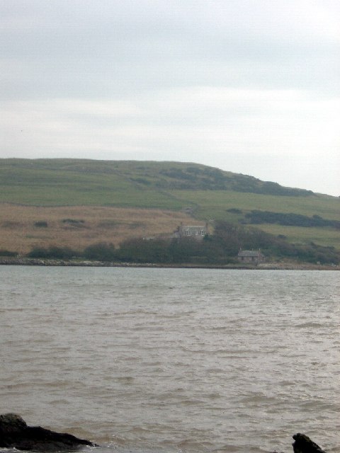
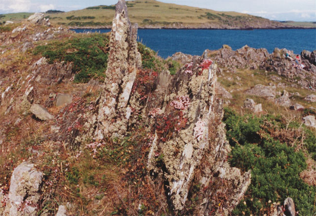
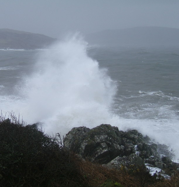
Rumblekirn is a prominent headland located in Kirkcudbrightshire, Scotland. It is situated on the coast near the town of Kirkcudbright and overlooks the Irish Sea. The headland is characterized by steep cliffs that rise up from the sea, offering stunning views of the surrounding coastline.

Rumblekirn is a popular spot for outdoor enthusiasts, with many visitors coming to enjoy hiking along the rugged cliffs and exploring the rocky shoreline. The headland is also known for its diverse wildlife, with seabirds such as gannets and puffins often seen nesting in the cliffs.

In addition to its natural beauty, Rumblekirn has historical significance as well. The headland is home to the remains of an ancient fort, which is thought to have been constructed during the Iron Age. This fort provides a glimpse into the area's rich history and offers visitors a chance to learn more about the people who once inhabited the region.

Overall, Rumblekirn is a must-visit destination for anyone seeking natural beauty, outdoor adventure, and a glimpse into Scotland's ancient past.

If you have any feedback on the listing, please let us know in the comments section below.

Rumblekirn Images

Images are sourced within 2km of 54.777022/-4.1449109 or Grid Reference NX6244. Thanks to Geograph Open Source API. All images are credited.

Mull of Ross from Brighouse Bay Rockvale farm near the shore
Mull of Ross from Brighouse Bay
Rockvale farm near the shore
Brighouse Bay looking SSE
House forsaken Eighteenth century folk had the energy and the resources to build fine homes like this even in remote places. With a gaudy caravan park less than a mile away, the real essence of rural life stands as a monument to our collective indifference to the efforts of our ancestors.
House forsaken
Eighteenth century folk had the energy and the resources to build fine homes like this even in remote places. With a gaudy caravan park less than a mile away, the real essence of rural life stands as a monument to our collective indifference to the efforts of our ancestors.
The big hoose at Borness, Galloway The daffodils are more advanced here than where I live much farther south than this.
The big hoose at Borness, Galloway
The daffodils are more advanced here than where I live much farther south than this.
Borness Point, Galloway The beautifully green rolling hills of Galloway give way to a very jagged coastline. It's like a beautiful woman with some rough edges and sharp nails
Borness Point, Galloway
The beautifully green rolling hills of Galloway give way to a very jagged coastline. It's like a beautiful woman with some rough edges and sharp nails
Galloway Coast Taken at Borness. The Galloway coastline can look menacing and runs counter to its undulating emerald greenery just behind.
Galloway Coast
Taken at Borness. The Galloway coastline can look menacing and runs counter to its undulating emerald greenery just behind.
Borness Point, Galloway It's a very exciting coastline
Borness Point, Galloway
It's a very exciting coastline
Brighouse Bay A beautiful south facing sandy bay with clear views to the Isle of Man on most days
Brighouse Bay
A beautiful south facing sandy bay with clear views to the Isle of Man on most days
Lichen-covered rocks, Brighouse bay
Brighouse Bay
Brighouse Bay
Muncraig Hill View View across grazing fields towards Whitehill from the Chapelton Row-Muncraig lane on southern slopes of Muncraig Hill.
Muncraig Hill View
View across grazing fields towards Whitehill from the Chapelton Row-Muncraig lane on southern slopes of Muncraig Hill.
Meteor Landing STREWTH ! - just stopped in time!
Meteor Landing
STREWTH ! - just stopped in time!
Cairn at Borness Bar Also showing the footpath down to Borness Batteries
Cairn at Borness Bar
Also showing the footpath down to Borness Batteries
Cairn on Mull of Ross Just big enough to be a cairn but a good spot nonetheless to view the Isle of Man on a clear day.
Cairn on Mull of Ross
Just big enough to be a cairn but a good spot nonetheless to view the Isle of Man on a clear day.
Cairn at Borness Bar
Harrison's Bay from Borness Point
Brighouse Bay near Dunrod Point
Brighouse Bay at low tide
Show me another place!

Rumblekirn is located at Grid Ref: NX6244 (Lat: 54.777022, Lng: -4.1449109)

Unitary Authority: Dumfries and Galloway

Police Authority: Dumfries and Galloway

What 3 Words

///clearly.riverbank.hormones. Near Kirkcudbright, Dumfries & Galloway

Related Wikis

Borness

Borness is a farm of around 1550 acres on the coast of Borgue Parish in the Stewartry of Kirkcudbrightshire (now part of Dumfries and Galloway). It is...

Borgue Old House

Borgue Old House is a ruined Y-plan house, about 300 metres (0.2 mi) east of Borgue in Dumfries and Galloway, Scotland. Built in 1680, but probably incorporating...

Borgue, Dumfries and Galloway

Borgue (pronounced /ˈbɔrɡ/; Scottish Gaelic: Borgh) is a village and parish in the Stewartry of Kirkcudbright in Dumfries and Galloway, Scotland. It lies...

Little Ross

Little Ross is a 29-acre (12-hectare) island with a lighthouse on the Solway Coast south of the town of Kirkcudbright in Galloway, Scotland. It is next...

Nearby Amenities

Located within 500m of 54.777022,-4.1449109
Source: PGS
Lat/Long: 54.7778198/-4.1524105
Source: PGS
Lat/Long: 54.7780975/-4.1488253
Source: PGS
Lat/Long: 54.7777675/-4.1479697
Source: PGS
Lat/Long: 54.7775226/-4.1484823
Source: PGS
Lat/Long: 54.7773026/-4.1485844
Source: PGS
Lat/Long: 54.7773353/-4.1472837
Source: PGS
Lat/Long: 54.7775932/-4.1465062
Source: PGS
Lat/Long: 54.7771844/-4.1455626
Source: PGS
Lat/Long: 54.7770633/-4.1453109
Source: PGS
Lat/Long: 54.7770039/-4.1446832
Source: PGS
Lat/Long: 54.7769828/-4.1429052
Source: PGS
Lat/Long: 54.7766745/-4.1434188
Source: PGS
Lat/Long: 54.7765523/-4.1434905
Source: PGS
Lat/Long: 54.7767177/-4.1427563
Source: PGS
Lat/Long: 54.7763083/-4.1432275
Source: PGS
Lat/Long: 54.7759943/-4.1423992
Source: PGS
Lat/Long: 54.77611/-4.138048
Source: PGS
Lat/Long: 54.7764644/-4.1377034
Bench
Lat/Long: 54.7784072/-4.1499174
The data included in this document is from www.openstreetmap.org. The data is made available under ODbL.

Have you been to Rumblekirn?

Leave your review of Rumblekirn below (or comments, questions and feedback).