Carreg y Trai

Coastal Feature, Headland, Point in Caernarfonshire

Wales

Carreg y Trai

St Tudwal's Islands from the Coastal Path
St Tudwal's Islands from the Coastal Path Credit: Dave Croker

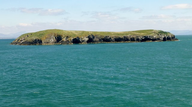
Carreg y Trai is a prominent coastal feature located in Caernarfonshire, Wales. Situated along the rugged Welsh coastline, this headland offers breathtaking views of the surrounding area and is a popular destination for tourists and locals alike.

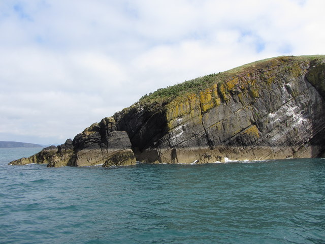
Rising approximately 100 meters above sea level, Carreg y Trai is characterized by its sheer cliffs and rocky outcrops, which have been shaped by centuries of coastal erosion. The headland is composed mainly of hard volcanic rock, giving it a distinct and striking appearance.

The name Carreg y Trai translates to "rock of the beach" in Welsh, reflecting its position overlooking the nearby sandy beaches. The headland acts as a natural barrier, protecting the coastline from the powerful forces of the sea and creating a sense of tranquility for those who visit.

Aside from its natural beauty, Carreg y Trai also holds historical significance. Ruins of an ancient watchtower, believed to date back to the Iron Age, can be found on the headland. This suggests that it was a strategic point for observing and defending the coastline in ancient times.

Visitors to Carreg y Trai can enjoy a variety of activities, such as hiking along the coastal paths, birdwatching, or simply admiring the panoramic views of the Irish Sea. It is also a popular spot for photographers, who are drawn to the dramatic scenery and ever-changing light.

In conclusion, Carreg y Trai in Caernarfonshire is a captivating coastal feature that offers a unique blend of natural beauty, historical significance, and recreational opportunities. Its rugged cliffs, ancient ruins, and stunning views make it an unforgettable destination for nature enthusiasts and history buffs alike.

If you have any feedback on the listing, please let us know in the comments section below.

Carreg y Trai Images

Images are sourced within 2km of 52.802495/-4.4499416 or Grid Reference SH3425. Thanks to Geograph Open Source API. All images are credited.

St Tudwal's Islands from the Coastal Path
St Tudwal's Island West from the shoreline
St Tudwal's Island East Note the seals on the rocks.
St Tudwal's Island East
Note the seals on the rocks.
Cave on St. Tudwal's Island East
Easternmost point of St. Tudwal's Island East
St. Tudwal's Island East
Caves on St. Tudwal's Island East
Seabirds on the cliffs of St. Tudwal's Island East
St. Tudwal's Islands
St. Tudwal's Island East
St. Tudwal's Island West
St Tudwal's Island West East wind made for a wet journey across from Abersoch on Carl's mini RIB. Bear Grylls gave permission for our 10 named island baggers to land. Trip organised by Adrian Rayner.
Name: St Tudwal's Island West
Hill number: 14855
Height: 44m / 144ft
Parent (Ma/M): none
Section: 30A: Anglesey and the Lleyn Peninsula
County/UA: Gwynedd (CoU)
Island: St Tudwal's Island West
Class: Tump (0-99m)
Grid ref: SH334252 (est)
Drop: 44m
Col: Sea
St Tudwal's Island West
East wind made for a wet journey across from Abersoch on Carl's mini RIB. Bear Grylls gave permission for our 10 named island baggers to land. Trip organised by Adrian Rayner. Name: St Tudwal's Island West Hill number: 14855 Height: 44m / 144ft Parent (Ma/M): none Section: 30A: Anglesey and the Lleyn Peninsula County/UA: Gwynedd (CoU) Island: St Tudwal's Island West Class: Tump (0-99m) Grid ref: SH334252 (est) Drop: 44m Col: Sea
A View North Along St Tudwal's Island West A view northwards from the southern end of St Tudwal's Island West.  East wind made for a wet journey across from Abersoch on Carl's mini RIB. Bear Grylls gave permission for our 10 named island baggers to land. Trip organised by Adrian Rayner.
A View North Along St Tudwal's Island West
A view northwards from the southern end of St Tudwal's Island West. East wind made for a wet journey across from Abersoch on Carl's mini RIB. Bear Grylls gave permission for our 10 named island baggers to land. Trip organised by Adrian Rayner.
Approaching A Cave Approaching a cave on the island of St Tudwal's Island East which is owned by Carla Lane's family.  We were in a mini RIB skippered by her son Carl.
Approaching A Cave
Approaching a cave on the island of St Tudwal's Island East which is owned by Carla Lane's family. We were in a mini RIB skippered by her son Carl.
View Towards St Tudwal's Island East A view towards St Tudwal's Island East taken from the track on St Tudwal's Island West.
View Towards St Tudwal's Island East
A view towards St Tudwal's Island East taken from the track on St Tudwal's Island West.
Show me another place!

Carreg y Trai is located at Grid Ref: SH3425 (Lat: 52.802495, Lng: -4.4499416)

Unitary Authority: Gwynedd

Police Authority: North Wales

What 3 Words

///puffy.hearths.toxins. Near Pwllheli, Gwynedd

Related Wikis

St Tudwal's Lighthouse

St Tudwal's Lighthouse on Saint Tudwal's Island West is active, but unstaffed. The site of the lighthouse, which marks the north end of Cardigan Bay, was...

Penrhyn Du Mines

The Penrhyn Du Mines are a collection of mines situated near Llanengan on the Llŷn Peninsula. It encompasses the Penrhyn, Assheton, Western and Tan-y-Bwlch...

Porth Ceiriad

Porth Ceiriad is a south-east facing beach and bay in the parish of Llanengan, near to Abersoch, in the county of Gwynedd, North Wales. It has several...

Abersoch

Abersoch (Welsh: [abɛrˈsoːχ]) is a village in the community of Llanengan in Gwynedd, Wales. It is a popular coastal seaside resort, with around 2,600 residents...

Nearby Amenities

Located within 500m of 52.802495,-4.4499416
Bell Bouy
Seamark Buoy Lateral Category: port
Seamark Buoy Lateral Colour: red
Seamark Buoy Lateral Shape: can
Seamark Buoy Lateral System: iala-a
Seamark Light Character: Fl
Seamark Light Colour: red
Seamark Light Period: 2.5
Seamark Name: Bell Bouy
Seamark Type: buoy_lateral
Lat/Long: 52.8026667/-4.4453333
The data included in this document is from www.openstreetmap.org. The data is made available under ODbL.

Have you been to Carreg y Trai?

Leave your review of Carreg y Trai below (or comments, questions and feedback).