Rubha Meadhonach

Coastal Feature, Headland, Point in Argyllshire

Scotland

Rubha Meadhonach

River Kinglass enters Loch Etive After 20 miles of moorland, this was a pleasant change.
River Kinglass enters Loch Etive Credit: AlastairG

Rubha Meadhonach is a prominent headland located in Argyllshire, Scotland. Situated along the western coast, this coastal feature boasts breathtaking views and is known for its rugged beauty. The name Rubha Meadhonach translates to "middle point" in Gaelic, in reference to its central location on the coast.

With its towering cliffs and dramatic landscape, Rubha Meadhonach stands as a remarkable natural landmark. The headland juts out into the sea, providing stunning panoramic vistas of the surrounding waters and distant islands. The rugged terrain is covered in lush vegetation, including heather, grasses, and ferns, adding to the area's charm and natural appeal.

Rubha Meadhonach is a popular destination for outdoor enthusiasts and nature lovers. Visitors can explore the headland by following the well-marked coastal paths that wind their way around the cliffs. These paths offer stunning views of the ocean, with opportunities to spot seabirds, seals, and other wildlife that inhabit the area.

The headland is also home to several historic sites, adding an element of cultural significance to its natural beauty. Ruins of ancient forts and settlements can be found scattered along the cliffs, providing insight into the area's rich history and heritage.

Accessible by foot or by boat, Rubha Meadhonach offers a tranquil escape from the hustle and bustle of everyday life. Whether it's for a leisurely hike, photography expedition, or simply to soak in the awe-inspiring views, this headland is a must-visit destination for anyone exploring the Argyllshire coastline.

If you have any feedback on the listing, please let us know in the comments section below.

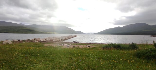
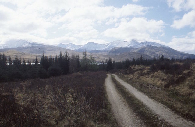
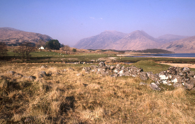
Rubha Meadhonach Images

Images are sourced within 2km of 56.503111/-5.1445105 or Grid Reference NN0638. Thanks to Geograph Open Source API. All images are credited.

River Kinglass enters Loch Etive After 20 miles of moorland, this was a pleasant change.
River Kinglass enters Loch Etive
After 20 miles of moorland, this was a pleasant change.
Loch Etive sighted Afte almost 20 miles from leaving Bridge of Orchy, Loch Etive is finally sighted. It turns out to be a false dawn as there is still a lot of soul destroying work to be done before reaching Taynuilt and the train.  A shower blows down the loch, thankfully the first rain of the walk. The camera position is an estimate as the road on the left bank of the river is fairly new and is not shown on any of the OS maps.
Loch Etive sighted
Afte almost 20 miles from leaving Bridge of Orchy, Loch Etive is finally sighted. It turns out to be a false dawn as there is still a lot of soul destroying work to be done before reaching Taynuilt and the train. A shower blows down the loch, thankfully the first rain of the walk. The camera position is an estimate as the road on the left bank of the river is fairly new and is not shown on any of the OS maps.
Rubha Bharr  View of the recently built stone loading jetty (not in regular use now)
Rubha Bharr
View of the recently built stone loading jetty (not in regular use now)
Old granite quarry and pier The remains of an old granite quarry/pier on Loch Etive, now largely reclaimed by woodland.
Old granite quarry and pier
The remains of an old granite quarry/pier on Loch Etive, now largely reclaimed by woodland.
Old pier just NE of Rubha na h-Oisinne One of several old piers on Loch Etive that serviced small granite quarries.
Old pier just NE of Rubha na h-Oisinne
One of several old piers on Loch Etive that serviced small granite quarries.
Track, gate and forest near Loch Etive
Fence above Loch Etive A deer fence around the forest
Fence above Loch Etive
A deer fence around the forest
Deer fence and Burn near Loch Etive
Land south of mouth of River Kinglass Grassland between track to Ardmaddy and mouth of River Kinglass
Land south of mouth of River Kinglass
Grassland between track to Ardmaddy and mouth of River Kinglass
Pier on Loch Etive Pier north of Ardmaddy.
Pier on Loch Etive
Pier north of Ardmaddy.
Mouth of River Kinglass Mouth of River Kinglass seen from track to Inverliver. This was taken around 15:30. Around 11:30 only the island with the trees was visible.
Mouth of River Kinglass
Mouth of River Kinglass seen from track to Inverliver. This was taken around 15:30. Around 11:30 only the island with the trees was visible.
View North up Loch Etive Photo taken on a warm day in late spring.
View North up Loch Etive
Photo taken on a warm day in late spring.
Abhainn Dalach, Loch Etive and Ben Cruachan Outlet of a big burn into Loch Etive.
Abhainn Dalach, Loch Etive and Ben Cruachan
Outlet of a big burn into Loch Etive.
Forest road above Dail A soon to be obscured view of Ben Cruachan.
Forest road above Dail
A soon to be obscured view of Ben Cruachan.
Abhainn Dalach View up the Abhainn Dalach towards Creach Bheinn.
Abhainn Dalach
View up the Abhainn Dalach towards Creach Bheinn.
Abhainn Dalach
Abhainn Dalach
Looking over Abhainn Dalach towards Dail
Allt Easach The Allt Easach from the bridge, more of a water slide at this point.
Allt Easach
The Allt Easach from the bridge, more of a water slide at this point.
Show me another place!

Rubha Meadhonach is located at Grid Ref: NN0638 (Lat: 56.503111, Lng: -5.1445105)

Unitary Authority: Argyll and Bute

Police Authority: Argyll and West Dunbartonshire

What 3 Words

///stance.parts.envelope. Near Glencoe, Highland

Related Wikis

Loch Etive

Loch Etive (Scottish Gaelic, Loch Eite) is a 30 km sea loch in Argyll and Bute, Scotland. It reaches the sea at Connel, 5 km north of Oban. It measures...

Beinn Trilleachan

Beinn Trilleachean (840 m) is a mountain in the Grampian Mountains, north of the village of Taynuilt at the head of Loch Etive. It lies on the border of...

Creach Bheinn (Loch Creran)

Creach Bheinn (810 m) is a mountain in the Grampian Mountains of Scotland. It rises above the head Loch Creran in Argyll. A large and sprawling peak, a...

Ben Starav

Ben Starav (Scottish Gaelic: Beinn Starabh) is a mountain in the Lorn region of Argyll, in the Scottish Highlands. It is a Munro that rises 1,078 metres...

Have you been to Rubha Meadhonach?

Leave your review of Rubha Meadhonach below (or comments, questions and feedback).