Black Rock

Coastal Feature, Headland, Point in Pembrokeshire

Wales

Black Rock

Great Castle Head Approaching this coastal feature from the south on the coast path. Beyond the headland is Westdale Bay.
Great Castle Head Credit: Gordon Hatton

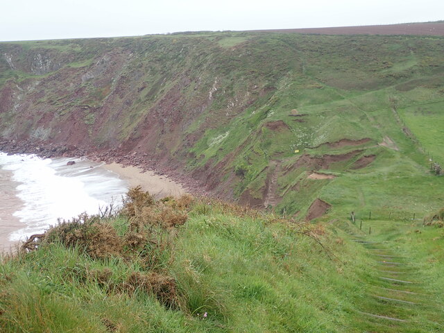
Black Rock is a prominent coastal feature located in Pembrokeshire, Wales. It is a rugged and imposing headland that juts out into the Irish Sea, offering stunning views of the surrounding coastline. The rock itself is a large, dark-colored formation that stands out against the lighter cliffs and sandy beaches in the area.

Black Rock is a popular destination for hikers and nature enthusiasts, with several walking trails and paths leading up to the headland. Visitors can enjoy panoramic views of the sea and nearby beaches, as well as the opportunity to spot a variety of seabirds and marine life.

The area surrounding Black Rock is known for its dramatic landscapes and diverse wildlife, making it a must-visit for anyone exploring the Pembrokeshire coast. The rugged beauty of the headland, combined with its rich natural heritage, makes it a unique and memorable destination for outdoor enthusiasts and nature lovers alike.

If you have any feedback on the listing, please let us know in the comments section below.

Black Rock Images

Images are sourced within 2km of 51.710796/-5.1672254 or Grid Reference SM8106. Thanks to Geograph Open Source API. All images are credited.

Great Castle Head Approaching this coastal feature from the south on the coast path. Beyond the headland is Westdale Bay.
Great Castle Head
Approaching this coastal feature from the south on the coast path. Beyond the headland is Westdale Bay.
Westdale Bay Beautiful Bay with fine sands, but with a reputation for dangerous rip tides making it unsafe for swimming.
Westdale Bay
Beautiful Bay with fine sands, but with a reputation for dangerous rip tides making it unsafe for swimming.
Atlantic surf, Westdale Bay Sand and surf at Westdale Bay, with the island of Skokholm some 6km out to sea.
Atlantic surf, Westdale Bay
Sand and surf at Westdale Bay, with the island of Skokholm some 6km out to sea.
Advancing tide at Westdale Bay Shining wet sands with the rocks at the base of Great Castle Head marching out into the Atlantic.
Advancing tide at Westdale Bay
Shining wet sands with the rocks at the base of Great Castle Head marching out into the Atlantic.
Northern access road into Dale airfield
Skeleton framework of a former hangar on Dale airfield
Dispersal area on the edge of Dale airfield Rather nice view over the upper reaches of Dale harbour in the background.
Dispersal area on the edge of Dale airfield
Rather nice view over the upper reaches of Dale harbour in the background.
Iron Point Looking down the cliffside to the jagged sandstone rocks of Iron Point. On the horizon, on the right is the coastline of The Marloes, Gateholm Island and behind it Skomer Island. Over to the left is Skokholm Island.
Iron Point
Looking down the cliffside to the jagged sandstone rocks of Iron Point. On the horizon, on the right is the coastline of The Marloes, Gateholm Island and behind it Skomer Island. Over to the left is Skokholm Island.
Ger / Near Iron Point Creigiau y mor ger Iron Point.

Sea rocks near Iron Point.
Ger / Near Iron Point
Creigiau y mor ger Iron Point. Sea rocks near Iron Point.
Westdale Bay Seen from the coast path
Westdale Bay
Seen from the coast path
Great Castle Head Fort It appears that much has fallen into the sea from this promontory fort
Great Castle Head Fort
It appears that much has fallen into the sea from this promontory fort
Remains of Buildings at RAF Kete Just a lot of brick, concrete and rubble remaining to indicate the past importance of this site ..... <span class="nowrap"><a title="http://www.derelictplaces.co.uk/main/ww2-defences/15230-st-annes-head-defences-pembrokeshire.html" rel="nofollow ugc noopener" href="http://www.derelictplaces.co.uk/main/ww2-defences/15230-st-annes-head-defences-pembrokeshire.html">Link</a><img style="margin-left:2px;" alt="External link" title="External link - shift click to open in new window" src="https://s1.geograph.org.uk/img/external.png" width="10" height="10"/></span>
Remains of Buildings at RAF Kete
Just a lot of brick, concrete and rubble remaining to indicate the past importance of this site ..... LinkExternal link
Pembrokeshire Coastal Path View from Pembrokeshire Coastal Path with Skokholm Island on the horizon.
Skokholm or Skokholm Island is an island 2.5 miles off the coast of Pembrokeshire, Wales, south of the neighbouring island of Skomer. The surrounding waters are a marine reserve and all are part of the Pembrokeshire Coast National Park. Both islands are listed as Sites of Special Scientific Interest. *Wikipedia
Pembrokeshire Coastal Path
View from Pembrokeshire Coastal Path with Skokholm Island on the horizon. Skokholm or Skokholm Island is an island 2.5 miles off the coast of Pembrokeshire, Wales, south of the neighbouring island of Skomer. The surrounding waters are a marine reserve and all are part of the Pembrokeshire Coast National Park. Both islands are listed as Sites of Special Scientific Interest. *Wikipedia
Dale Airfield & The Hookses **For those who know the Hookses, that hidden, hook-shaped valley cut out of the Pembrokeshire cliffs, the name has an almost mythical quality. It is intimately associated with John Stott, the author, evangelist, and church leader who bought its abandoned cottage and associated outhouses in 1954, restored them, and made them available as a place of writing, retreat, and renewal ever after.
** Courtesy Church Times.
Dale Airfield & The Hookses
**For those who know the Hookses, that hidden, hook-shaped valley cut out of the Pembrokeshire cliffs, the name has an almost mythical quality. It is intimately associated with John Stott, the author, evangelist, and church leader who bought its abandoned cottage and associated outhouses in 1954, restored them, and made them available as a place of writing, retreat, and renewal ever after. ** Courtesy Church Times.
Kissing gate and stile at Westdale Bay The path from Dale joins the Coast Path here
Kissing gate and stile at Westdale Bay
The path from Dale joins the Coast Path here
Westdale Bay The sea turning pink from the sandstone sediment
Westdale Bay
The sea turning pink from the sandstone sediment
The Coast Path at Westdale Bay The path heading up steps to the site of Great Castle Head, an Iron Age promontory fort
The Coast Path at Westdale Bay
The path heading up steps to the site of Great Castle Head, an Iron Age promontory fort
Westdale Bay from Great Castle Head Lots of signs of landslips.
Westdale Bay from Great Castle Head
Lots of signs of landslips.
Show me another place!

Black Rock is located at Grid Ref: SM8106 (Lat: 51.710796, Lng: -5.1672254)

Unitary Authority: Pembrokeshire

Police Authority: Dyfed Powys

What 3 Words

///affair.garage.occupiers. Near Dale, Pembrokeshire

Related Wikis

Dale, Pembrokeshire

Dale is both a small village and a community in Pembrokeshire, Wales, located on the peninsula which forms the northern side of the entrance to the Milford...

Dale Castle

Dale Castle is a 13th-century castle located close to the village of Dale in Pembrokeshire, Wales. In 1910, part of the castle was removed and other parts...

Dale Fort

Dale Fort is a mid-19th-century coastal artillery fort at Dale Head, a rocky promontory near Dale, Pembrokeshire, west of Milford Haven in Wales. It is...

RNAS Dale (HMS Goldcrest)

Royal Naval Air Station Dale (RNAS Dale, also known as HMS Goldcrest) is a former Royal Naval Air Station, located 10 miles (16 km) South West of Haverfordwest...

Nearby Amenities

Located within 500m of 51.710796,-5.1672254
Source: PGS
Lat/Long: 51.7069573/-5.1683199
Source: PGS
Lat/Long: 51.7095805/-5.1685211
Dale
Created By: Potlatch 0.8b
Is In: Pembrokeshire
Place: village
Wikidata: Q3012283
Lat/Long: 51.7075201/-5.1694437
Parking
Dale
Description: pay and display
Fee: yes
Operator: Pembroke County Council
Operator Type: public
Parking: surface
Payment Cash: yes
Lat/Long: 51.7086213/-5.1694501
Toilets
Access: yes
Changing Table: yes
Fee: no
Female: yes
Toilets Disposal: flush
Wheelchair: yes
Lat/Long: 51.7073185/-5.1696633
Dale Post Office
Disused Amenity: post_office
Lat/Long: 51.7068712/-5.1690481
Pub
Griffin Inn
Addr Postcode: SA62 3RB
Fhrs Id: 856500
Phone: +44 1646 636227
Source Addr Postcode: FHRS Open Data
Website: https://griffindale.co.uk
Wikidata: Q29496571
Lat/Long: 51.7071954/-5.1689657
Allenbrook
Addr City: Dale
Addr Housename: Allenbrook
Addr Postcode: SA62 3RN
Addr Street: Castle Way
Tourism: guest_house
Website: https://www.allenbrook-dale.co.uk/
Lat/Long: 51.7092872/-5.1705872
Power: pole
Lat/Long: 51.713436/-5.1722458
Location Transition: yes
Power: pole
Lat/Long: 51.7098213/-5.1737344
Location Transition: yes
Power: pole
Lat/Long: 51.7090742/-5.1736848
Power: pole
Lat/Long: 51.7093135/-5.1723705
Power: pole
Lat/Long: 51.7094348/-5.1717483
Power: pole
Lat/Long: 51.7095412/-5.171134
Power: pole
Lat/Long: 51.7096733/-5.1704367
Direction: 165
Generator Method: photovoltaic
Generator Output Electricity: yes
Generator Solar Modules: 4
Generator Source: solar
Generator Type: solar_photovoltaic_panel
Location: roof
Power: generator
Lat/Long: 51.7105492/-5.1692699
Direction: 165
Generator Method: photovoltaic
Generator Output Electricity: yes
Generator Solar Modules: 10
Generator Source: solar
Generator Type: solar_photovoltaic_panel
Location: roof
Power: generator
Lat/Long: 51.7105151/-5.1693825
Direction: 165
Generator Method: photovoltaic
Generator Output Electricity: yes
Generator Solar Modules: 14
Generator Source: solar
Generator Type: solar_photovoltaic_panel
Location: roof
Power: generator
Lat/Long: 51.7089803/-5.172911
Direction: WSW
Generator Method: photovoltaic
Generator Output Electricity: yes
Generator Solar Modules: 10
Generator Source: solar
Generator Type: solar_photovoltaic_panel
Location: roof
Power: generator
Lat/Long: 51.7129732/-5.1731618
Cafe
Boathouse Cafe
Lat/Long: 51.7075903/-5.1693388
Post Box
Brand: Royal Mail
Brand Wikidata: Q638098
Collection Times: Mo-Fr 16:00; Sa 12:00
Operator: Royal Mail
Operator Wikidata: Q638098
Post Box Type: lamp
Ref: SA62 147
Royal Cypher: EIIR
Royal Cypher Wikidata: Q33102113
Lat/Long: 51.7068371/-5.1690365
Post Box
Brand: Royal Mail
Brand Wikidata: Q638098
Collection Times: Mo-Fr 12:30; Sa 12:30
Operator: Royal Mail
Operator Wikidata: Q638098
Post Box Type: lamp
Ref: SA62 169
Royal Cypher: EIIR
Royal Cypher Wikidata: Q33102113
Lat/Long: 51.7097003/-5.1694424
The data included in this document is from www.openstreetmap.org. The data is made available under ODbL.

Have you been to Black Rock?

Leave your review of Black Rock below (or comments, questions and feedback).