Rubha na h-Àirde Glaise

Coastal Feature, Headland, Point in Inverness-shire

Scotland

Rubha na h-Àirde Glaise

A87 near Kyleakin
A87 near Kyleakin Credit: Steven Brown

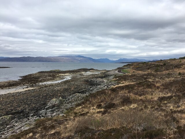
Rubha na h-Àirde Glaise is a prominent coastal feature located in Inverness-shire, Scotland. It is a headland or point that juts out into the North Atlantic Ocean, offering stunning panoramic views of the surrounding landscape. The headland is situated approximately 5 miles northeast of the village of Lochcarron.

The name Rubha na h-Àirde Glaise is derived from Gaelic, which translates to "point of the green height." This name accurately describes the headland's physical characteristics, as it is characterized by its green, grassy slopes that rise to a considerable height above sea level. The headland is composed of rugged cliffs that provide habitat for a variety of seabirds, making it a popular spot for birdwatching enthusiasts.

The headland also boasts a rocky shoreline, with numerous small coves and inlets that add to its scenic beauty. These coves provide opportunities for exploring tide pools and discovering marine life during low tide. The headland is surrounded by clear, pristine waters, making it a favored spot for snorkeling and diving.

Access to Rubha na h-Àirde Glaise is relatively easy, with a well-maintained footpath leading from a nearby parking area. The footpath offers hikers the chance to experience the headland's natural beauty up close, as they traverse its undulating terrain.

Overall, Rubha na h-Àirde Glaise is a breathtaking coastal feature that offers a unique combination of dramatic cliffs, lush greenery, and abundant wildlife. It is a must-visit destination for nature enthusiasts and those seeking a tranquil escape amidst Scotland's stunning coastal landscapes.

If you have any feedback on the listing, please let us know in the comments section below.

Rubha na h-Àirde Glaise Images

Images are sourced within 2km of 57.271224/-5.7674206 or Grid Reference NG7226. Thanks to Geograph Open Source API. All images are credited.

A87 near Kyleakin
A87 near Kyleakin
Trig point near Kyleakin
Shoreline near Kyleakin
Ruined buildings near the shore
A87 at Kyleakin
A87 at Kyleakin
Skye Bridge The Skye Bridge (Scottish Gaelic: Drochaid an Eilein Sgitheanaich) is a road bridge over Loch Alsh connecting the Isle of Skye to the island of Eilean Bàn. The name is also used for the whole Skye Crossing, which further connects Eilean Bàn to the mainland across the Carrich Viaduct. The crossing forms part of the A87 road. The bridge was opened in 1995, replacing the ferry between Kyle of Lochalsh and Kyleakin.
Skye Bridge
The Skye Bridge (Scottish Gaelic: Drochaid an Eilein Sgitheanaich) is a road bridge over Loch Alsh connecting the Isle of Skye to the island of Eilean Bàn. The name is also used for the whole Skye Crossing, which further connects Eilean Bàn to the mainland across the Carrich Viaduct. The crossing forms part of the A87 road. The bridge was opened in 1995, replacing the ferry between Kyle of Lochalsh and Kyleakin.
Crossing the Skye Bridge The Skye Bridge (Scottish Gaelic: Drochaid an Eilein Sgitheanaich) is a road bridge over Loch Alsh connecting the Isle of Skye to the island of Eilean Bàn. The name is also used for the whole Skye Crossing, which further connects Eilean Bàn to the mainland across the Carrich Viaduct. The crossing forms part of the A87 road. The bridge was opened in 1995, replacing the ferry between Kyle of Lochalsh and Kyleakin.
Crossing the Skye Bridge
The Skye Bridge (Scottish Gaelic: Drochaid an Eilein Sgitheanaich) is a road bridge over Loch Alsh connecting the Isle of Skye to the island of Eilean Bàn. The name is also used for the whole Skye Crossing, which further connects Eilean Bàn to the mainland across the Carrich Viaduct. The crossing forms part of the A87 road. The bridge was opened in 1995, replacing the ferry between Kyle of Lochalsh and Kyleakin.
Approaching Skye via the Skye Bridge The Skye Bridge (Scottish Gaelic: Drochaid an Eilein Sgitheanaich) is a road bridge over Loch Alsh connecting the Isle of Skye to the island of Eilean Bàn. The name is also used for the whole Skye Crossing, which further connects Eilean Bàn to the mainland across the Carrich Viaduct. The crossing forms part of the A87 road. The bridge was opened in 1995, replacing the ferry between Kyle of Lochalsh and Kyleakin.
Approaching Skye via the Skye Bridge
The Skye Bridge (Scottish Gaelic: Drochaid an Eilein Sgitheanaich) is a road bridge over Loch Alsh connecting the Isle of Skye to the island of Eilean Bàn. The name is also used for the whole Skye Crossing, which further connects Eilean Bàn to the mainland across the Carrich Viaduct. The crossing forms part of the A87 road. The bridge was opened in 1995, replacing the ferry between Kyle of Lochalsh and Kyleakin.
A87 on Skye The A87 is a primary route  in the Highland region of Scotland. It runs west for 99 miles from its junction with the A82 at Invergarry, along the north shores of Loch Garry and Loch Cluanie, then through Glen Shiel and along Loch Duich to Kyle of Lochalsh before crossing the Skye Bridge to Kyleakin, Broadford, and Portree, before terminating at Uig in the north of the Isle of Skye.
A87 on Skye
The A87 is a primary route in the Highland region of Scotland. It runs west for 99 miles from its junction with the A82 at Invergarry, along the north shores of Loch Garry and Loch Cluanie, then through Glen Shiel and along Loch Duich to Kyle of Lochalsh before crossing the Skye Bridge to Kyleakin, Broadford, and Portree, before terminating at Uig in the north of the Isle of Skye.
A87 between Kyleakin and Broadford The A87 is a primary route  in the Highland region of Scotland. It runs west for 99 miles from its junction with the A82 at Invergarry, along the north shores of Loch Garry and Loch Cluanie, then through Glen Shiel and along Loch Duich to Kyle of Lochalsh before crossing the Skye Bridge to Kyleakin, Broadford, and Portree, before terminating at Uig in the north of the Isle of Skye.
A87 between Kyleakin and Broadford
The A87 is a primary route in the Highland region of Scotland. It runs west for 99 miles from its junction with the A82 at Invergarry, along the north shores of Loch Garry and Loch Cluanie, then through Glen Shiel and along Loch Duich to Kyle of Lochalsh before crossing the Skye Bridge to Kyleakin, Broadford, and Portree, before terminating at Uig in the north of the Isle of Skye.
Layby on the A87 near Kyleakin The A87 is a primary route  in the Highland region of Scotland. It runs west for 99 miles from its junction with the A82 at Invergarry, along the north shores of Loch Garry and Loch Cluanie, then through Glen Shiel and along Loch Duich to Kyle of Lochalsh before crossing the Skye Bridge to Kyleakin, Broadford, and Portree, before terminating at Uig in the north of the Isle of Skye.
Layby on the A87 near Kyleakin
The A87 is a primary route in the Highland region of Scotland. It runs west for 99 miles from its junction with the A82 at Invergarry, along the north shores of Loch Garry and Loch Cluanie, then through Glen Shiel and along Loch Duich to Kyle of Lochalsh before crossing the Skye Bridge to Kyleakin, Broadford, and Portree, before terminating at Uig in the north of the Isle of Skye.
Leaving Skye via the Skye Bridge The Skye Bridge (Scottish Gaelic: Drochaid an Eilein Sgitheanaich) is a road bridge over Loch Alsh connecting the Isle of Skye to the island of Eilean Bàn. The name "Skye Bridge" is also used for the whole Skye Crossing, which further connects Eilean Bàn to the mainland across the Carrich Viaduct. The crossing forms part of the A87 road. The bridge was opened in 1995, replacing the ferry between Kyle of Lochalsh and Kyleakin.
Leaving Skye via the Skye Bridge
The Skye Bridge (Scottish Gaelic: Drochaid an Eilein Sgitheanaich) is a road bridge over Loch Alsh connecting the Isle of Skye to the island of Eilean Bàn. The name "Skye Bridge" is also used for the whole Skye Crossing, which further connects Eilean Bàn to the mainland across the Carrich Viaduct. The crossing forms part of the A87 road. The bridge was opened in 1995, replacing the ferry between Kyle of Lochalsh and Kyleakin.
Pedestrians crossing the Skye Bridge The Skye Bridge (Scottish Gaelic: Drochaid an Eilein Sgitheanaich) is a road bridge over Loch Alsh connecting the Isle of Skye to the island of Eilean Bàn. The name "Skye Bridge" is also used for the whole Skye Crossing, which further connects Eilean Bàn to the mainland across the Carrich Viaduct. The crossing forms part of the A87 road. The bridge was opened in 1995, replacing the ferry between Kyle of Lochalsh and Kyleakin.
Pedestrians crossing the Skye Bridge
The Skye Bridge (Scottish Gaelic: Drochaid an Eilein Sgitheanaich) is a road bridge over Loch Alsh connecting the Isle of Skye to the island of Eilean Bàn. The name "Skye Bridge" is also used for the whole Skye Crossing, which further connects Eilean Bàn to the mainland across the Carrich Viaduct. The crossing forms part of the A87 road. The bridge was opened in 1995, replacing the ferry between Kyle of Lochalsh and Kyleakin.
Skye Bridge, Eilean Bàn Eilean Bàn, the white island, lies between The Isle of Skye and mainland Scotland. It is the site of a Stevenson lighthouse and supports the north end of the Skye Bridge. The island is managed by the Eilean Bàn Trust as a wildlife haven and memorial to its former owner, the naturalist and author Gavin Maxwell. Maxwell lived on the island in the few years before his death in 1969.
Skye Bridge, Eilean Bàn
Eilean Bàn, the white island, lies between The Isle of Skye and mainland Scotland. It is the site of a Stevenson lighthouse and supports the north end of the Skye Bridge. The island is managed by the Eilean Bàn Trust as a wildlife haven and memorial to its former owner, the naturalist and author Gavin Maxwell. Maxwell lived on the island in the few years before his death in 1969.
Skye Bridge
Skye Bridge
Skye bridge from Plock of Kyle The A87 runs 99 miles from Invergarry to Uig on the Isle of Skye <a href="https://www.geograph.org.uk/photo/7374675">NG3863 : End of the A87, Uig</a>.
<span class="nowrap"><a title="https://www.sabre-roads.org.uk/wiki/index.php?title=A87" rel="nofollow ugc noopener" href="https://www.sabre-roads.org.uk/wiki/index.php?title=A87">Link</a><img style="margin-left:2px;" alt="External link" title="External link - shift click to open in new window" src="https://s1.geograph.org.uk/img/external.png" width="10" height="10"/></span>
Skye bridge from Plock of Kyle
The A87 runs 99 miles from Invergarry to Uig on the Isle of Skye NG3863 : End of the A87, Uig. LinkExternal link
View to Skye Bridge from Plock of Kyle The A87 runs 99 miles from Invergarry to Uig on the Isle of Skye <a href="https://www.geograph.org.uk/photo/7374675">NG3863 : End of the A87, Uig</a>.
<span class="nowrap"><a title="https://www.sabre-roads.org.uk/wiki/index.php?title=A87" rel="nofollow ugc noopener" href="https://www.sabre-roads.org.uk/wiki/index.php?title=A87">Link</a><img style="margin-left:2px;" alt="External link" title="External link - shift click to open in new window" src="https://s1.geograph.org.uk/img/external.png" width="10" height="10"/></span>
View to Skye Bridge from Plock of Kyle
The A87 runs 99 miles from Invergarry to Uig on the Isle of Skye NG3863 : End of the A87, Uig. LinkExternal link
Show me another place!

Rubha na h-Àirde Glaise is located at Grid Ref: NG7226 (Lat: 57.271224, Lng: -5.7674206)

Unitary Authority: Highland

Police Authority: Highlands and Islands

What 3 Words

///nicknames.wiggles.exams. Near Kyleakin, Highland

Related Wikis

Eilean Bàn

Eilean Bàn (Scottish Gaelic meaning White Island) is a six-acre (2.4 ha) island between Kyle of Lochalsh and the Isle of Skye, in the historic county of...
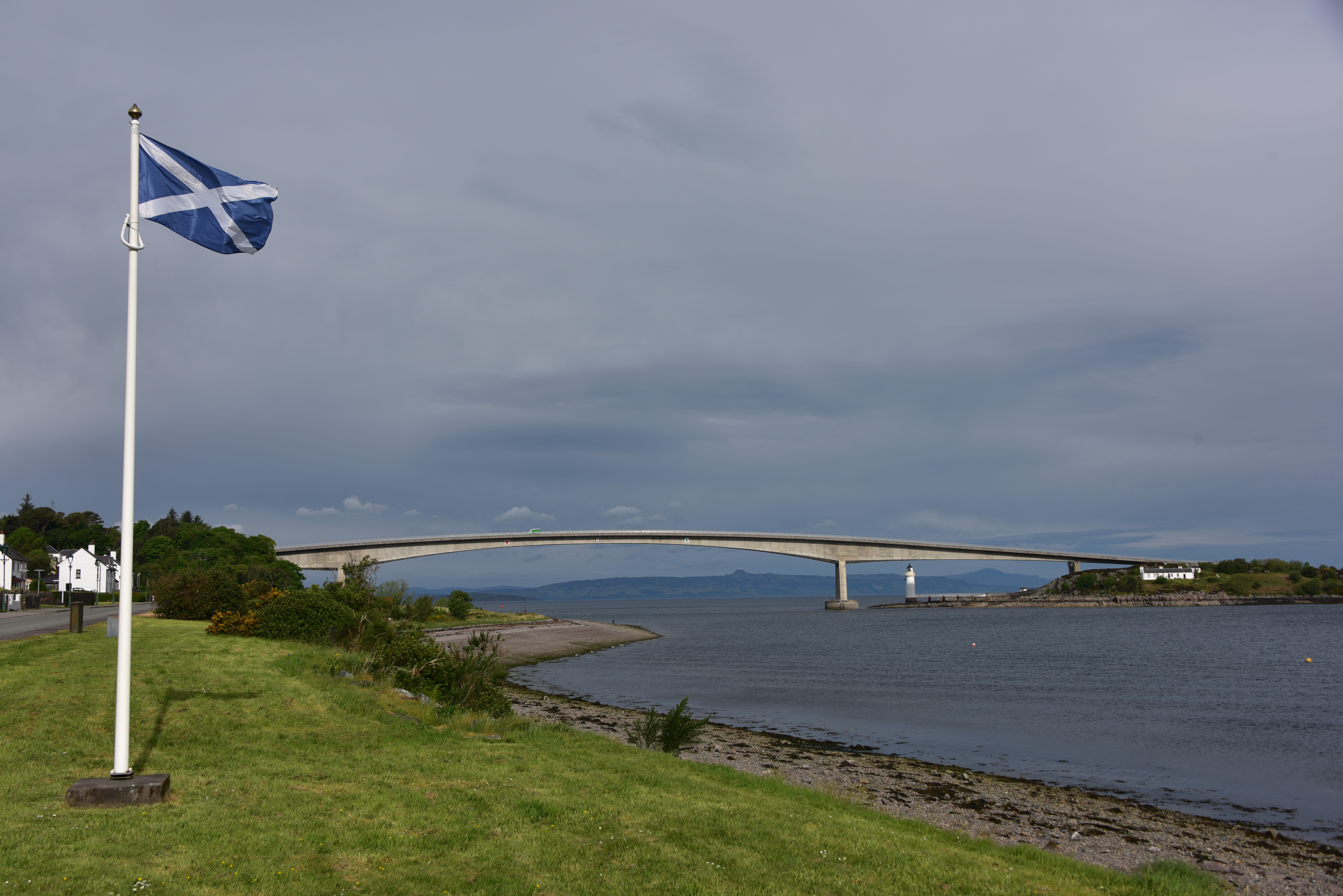
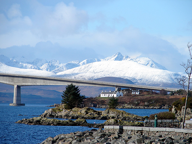
Skye Bridge

The Skye Bridge (Scottish Gaelic: Drochaid an Eilein Sgitheanaich) is a road bridge over Loch Alsh, Scotland, connecting the Isle of Skye to the island...

Kyleakin

Kyleakin (; Scottish Gaelic: Caol Àcain) is a village situated on the east coast of the Isle of Skye in the Inner Hebrides, Scotland. The village is along...
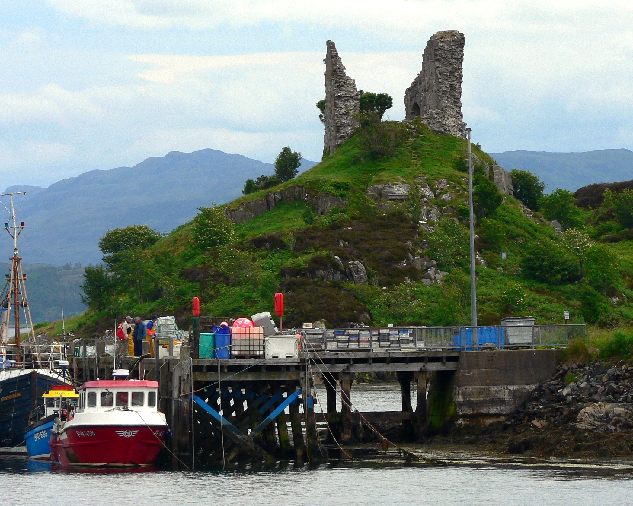
Caisteal Maol

Caisteal Maol (Gaelic: Caisteal, 'Castle', Maol, 'bare') is a ruined castle located near the harbour of the village of Kyleakin, Isle of Skye, Scotland...

Nearby Amenities

Located within 500m of 57.271224,-5.7674206
Source: PGS
Lat/Long: 57.2715991/-5.7601208
Source: PGS
Lat/Long: 57.2713242/-5.7616952
Source: PGS
Lat/Long: 57.2712597/-5.7628764
Source: PGS
Lat/Long: 57.2715956/-5.7643493
Source: PGS
Lat/Long: 57.2722007/-5.7640499
Source: PGS
Lat/Long: 57.2722823/-5.7641235
Source: PGS
Lat/Long: 57.2725242/-5.7642026
Source: PGS
Lat/Long: 57.2724444/-5.7649756
Source: PGS
Lat/Long: 57.2722218/-5.7661671
Source: PGS
Lat/Long: 57.2720857/-5.7666404
Source: PGS
Lat/Long: 57.2716079/-5.7694135
Source: PGS
Lat/Long: 57.2715951/-5.7724266
Source: PGS
Lat/Long: 57.2708866/-5.7744682
Source: PGS
Lat/Long: 57.2706653/-5.7752502
The data included in this document is from www.openstreetmap.org. The data is made available under ODbL.

Have you been to Rubha na h-Àirde Glaise?

Leave your review of Rubha na h-Àirde Glaise below (or comments, questions and feedback).