Àird Mhòr

Coastal Feature, Headland, Point in Ross-shire

Scotland

Àird Mhòr

Ripe for development Roofless cottage and tin roofed barn on the shore at Coillegillie, and the only two buildings which appear to be in this grid square. The cottage has a polite notice attached asking visitors to respect the property as there are plans to rebuild it. The view extends to the Red Cuillin on Skye and the southern end of Raasay.
Ripe for development Credit: Gordon Hatton

Àird Mhòr is a prominent coastal feature located in Ross-shire, Scotland. It is a headland that extends into the North Atlantic Ocean, forming a distinctive and picturesque point along the rugged coastline. The name Àird Mhòr translates to "big headland" in Scottish Gaelic, an apt description of its size and prominence.

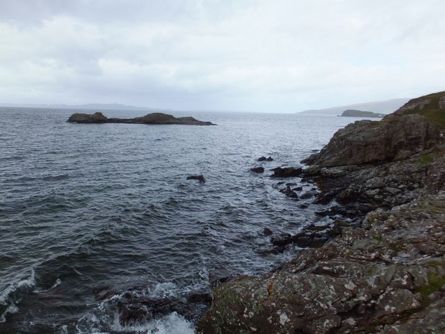
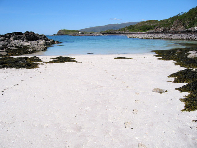
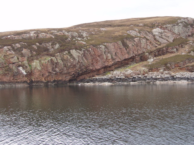
Situated on the northwest coast of Scotland, Àird Mhòr offers breathtaking panoramic views of the surrounding landscape. The headland is characterized by towering cliffs, which provide a dramatic backdrop against the crashing waves of the Atlantic. These cliffs are composed of distinct layers of sedimentary rock, showcasing a fascinating geological history.

The coastal area surrounding Àird Mhòr is abundant in wildlife, making it a popular spot for nature enthusiasts. Seabird colonies can be found nesting on the cliffs, including species such as puffins, kittiwakes, and guillemots. Marine mammals, such as seals and dolphins, can often be spotted in the waters around the headland.

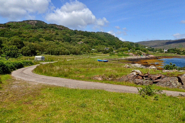
The headland is easily accessible through a network of walking trails, offering visitors the opportunity to explore its rugged beauty. Hiking along the cliff edges provides unparalleled views of the ocean and the nearby islands. Additionally, there are several viewpoints strategically placed along the trails, allowing visitors to pause and take in the breathtaking scenery.

Overall, Àird Mhòr is a remarkable coastal feature that showcases the natural beauty and diversity of the Scottish coastline. Its stunning cliffs, abundant wildlife, and panoramic views make it a must-visit destination for nature lovers and outdoor enthusiasts alike.

If you have any feedback on the listing, please let us know in the comments section below.

Àird Mhòr Images

Images are sourced within 2km of 57.367313/-5.8182635 or Grid Reference NG7037. Thanks to Geograph Open Source API. All images are credited.

Ripe for development Roofless cottage and tin roofed barn on the shore at Coillegillie, and the only two buildings which appear to be in this grid square. The cottage has a polite notice attached asking visitors to respect the property as there are plans to rebuild it. The view extends to the Red Cuillin on Skye and the southern end of Raasay.
Ripe for development
Roofless cottage and tin roofed barn on the shore at Coillegillie, and the only two buildings which appear to be in this grid square. The cottage has a polite notice attached asking visitors to respect the property as there are plans to rebuild it. The view extends to the Red Cuillin on Skye and the southern end of Raasay.
Thrift by the shore More commonly known wrongly as 'sea pinks', thrift is common along rocky shorelines around most of Britain.
Thrift by the shore
More commonly known wrongly as 'sea pinks', thrift is common along rocky shorelines around most of Britain.
An Ruard-Eilean Small island off the rocky coastline to the north of Coilliegillie
An Ruard-Eilean
Small island off the rocky coastline to the north of Coilliegillie
An Ruadh-eilean Rounding the rocky skerry heading towards the ruined settlement of Coillegillie. Raasay and then Skye in the background.
An Ruadh-eilean
Rounding the rocky skerry heading towards the ruined settlement of Coillegillie. Raasay and then Skye in the background.
Low tide at An Ruadh-eilean
Beach at An Ruadh-eilean
Sgeir Bhuidhe Sgeir Bhuidhe is a little skerry just off the southern tip of Eilean na Ba.  Immediately beyond can be seen the Crowlin Islands; beyond that, Scalpay and Skye.
Sgeir Bhuidhe
Sgeir Bhuidhe is a little skerry just off the southern tip of Eilean na Ba. Immediately beyond can be seen the Crowlin Islands; beyond that, Scalpay and Skye.
The road through Toscaig With Toscaig phonebox ahead.
The road through Toscaig
With Toscaig phonebox ahead.
Toscaig letterbox
Toscaig letterbox
View to the head of Loch Toscaig
Looking across Loch Toscaig
House by Toscaig pier
Triangulation pillar, Carn Donnachaidh, Ross and Cromarty Looking towards Skye.

The pillar is the cylindrical "Vanessa" type.
Triangulation pillar, Carn Donnachaidh, Ross and Cromarty
Looking towards Skye. The pillar is the cylindrical "Vanessa" type.
Rock shelter, Coille Ghillidh, Ross and Cromarty Historic Environment Scotland describes a rock shelter as, "the area beneath a natural overhang at the base of a cliff or crag. This may have been used for occupation, burial, etc". This shelter was recorded during the Scotland's First Settlers Project: <span class="nowrap"><a title="https://canmore.org.uk/site/317869/coilliegillie" rel="nofollow ugc noopener" href="https://canmore.org.uk/site/317869/coilliegillie">Link</a><img style="margin-left:2px;" alt="External link" title="External link - shift click to open in new window" src="https://s1.geograph.org.uk/img/external.png" width="10" height="10"/></span>.
Rock shelter, Coille Ghillidh, Ross and Cromarty
Historic Environment Scotland describes a rock shelter as, "the area beneath a natural overhang at the base of a cliff or crag. This may have been used for occupation, burial, etc". This shelter was recorded during the Scotland's First Settlers Project: LinkExternal link.
Cairn, Carn Donnachaidh, Ross and Cromarty Looking towards Loch Toscaig.
Cairn, Carn Donnachaidh, Ross and Cromarty
Looking towards Loch Toscaig.
Toscaig jetty
Toscaig jetty
Toscaig
Toscaig
Shed, Toscaig
Shed, Toscaig
Show me another place!

Àird Mhòr is located at Grid Ref: NG7037 (Lat: 57.367313, Lng: -5.8182635)

Unitary Authority: Highland

Police Authority: Highlands and Islands

What 3 Words

///unsettled.ghost.fines. Near Kyleakin, Highland

Related Wikis

Toscaig

Toscaig (Scottish Gaelic: Toghsgaig) is a small, remote village, at the southern end of the Applecross peninsula, in Wester Ross in the Highlands of Scotland...

Crowlin Islands

The Crowlin Islands (Scottish Gaelic: Na h-Eileanan Cròlainneach) are a group of uninhabited islands in the Inner Hebrides of Scotland. They lie between...

Eilean Mòr, Crowlin Islands

Eilean Mòr is the largest of the Crowlin Islands in the Inner Sound off the Isle of Skye, Scotland. Eilean Mòr is situated at the mouth of Loch Carron...

Eilean Meadhonach

Eilean Meadhonach is the second largest of the Crowlin Islands, located in the Inner Sound off the island of Skye, Scotland. It is situated immediately...

Nearby Amenities

Located within 500m of 57.367313,-5.8182635
Source: PGS
Lat/Long: 57.3705513/-5.8238397
Source: PGS
Lat/Long: 57.370368/-5.823773
Source: PGS
Lat/Long: 57.3699238/-5.8237407
Source: PGS
Lat/Long: 57.3693922/-5.8238681
Source: PGS
Lat/Long: 57.3692359/-5.8237813
Source: PGS
Lat/Long: 57.3687952/-5.823684
Source: PGS
Lat/Long: 57.3680059/-5.8239006
Source: PGS
Lat/Long: 57.3679013/-5.8239082
Source: PGS
Lat/Long: 57.3677286/-5.8237854
Source: PGS
Lat/Long: 57.3675273/-5.8236544
Source: PGS
Lat/Long: 57.3673889/-5.8235309
Source: PGS
Lat/Long: 57.3672776/-5.8234785
Source: PGS
Lat/Long: 57.3670995/-5.823349
Source: PGS
Lat/Long: 57.3667955/-5.8231198
Source: PGS
Lat/Long: 57.3665613/-5.8230785
Source: PGS
Lat/Long: 57.3664095/-5.8228939
Source: PGS
Lat/Long: 57.3658649/-5.8225189
Source: PGS
Lat/Long: 57.365717/-5.8224652
Created By: almien_coastlines
Source: PGS
Lat/Long: 57.365667/-5.822417
Source: PGS
Lat/Long: 57.3650117/-5.8217897
Source: PGS
Lat/Long: 57.3649458/-5.8212982
Source: PGS
Lat/Long: 57.3645608/-5.8213896
Source: PGS
Lat/Long: 57.3640372/-5.8220414
Source: PGS
Lat/Long: 57.3638644/-5.8222743
Source: PGS
Lat/Long: 57.3636328/-5.8223435
Source: PGS
Lat/Long: 57.3634245/-5.8221665
Source: PGS
Lat/Long: 57.3633412/-5.8217114
Source: PGS
Lat/Long: 57.364181/-5.8126168
Source: PGS
Lat/Long: 57.3644714/-5.8129313
Source: PGS
Lat/Long: 57.3647925/-5.8129918
Source: PGS
Lat/Long: 57.3652116/-5.8128106
Source: PGS
Lat/Long: 57.3652837/-5.8126513
Source: PGS
Lat/Long: 57.3656029/-5.8126314
Source: PGS
Lat/Long: 57.36576/-5.812779
Natural: cave_entrance
Source: survey
Lat/Long: 57.365879/-5.812953
Source: PGS
Lat/Long: 57.366713/-5.8138684
Created By: almien_coastlines
Source: PGS
Lat/Long: 57.367647/-5.814036
Created By: almien_coastlines
Source: PGS
Lat/Long: 57.367903/-5.814056
Created By: almien_coastlines
Source: PGS
Lat/Long: 57.368414/-5.814095
Source: PGS
Lat/Long: 57.3687288/-5.8148504
Source: PGS
Lat/Long: 57.3695269/-5.815432
Source: PGS
Lat/Long: 57.3697832/-5.815632
Created By: almien_coastlines
Source: PGS
Lat/Long: 57.370167/-5.815888
Created By: almien_coastlines
Source: PGS
Lat/Long: 57.370316/-5.814951
Source: PGS
Lat/Long: 57.3702992/-5.8147474
Created By: almien_coastlines
Source: PGS
Lat/Long: 57.370348/-5.813531
Created By: almien_coastlines
Source: PGS
Lat/Long: 57.370481/-5.813305
Source: PGS
Lat/Long: 57.3706293/-5.8131266
Camas na Ba
Natural: bay
Lat/Long: 57.369528/-5.8143555
The data included in this document is from www.openstreetmap.org. The data is made available under ODbL.

Have you been to Àird Mhòr?

Leave your review of Àird Mhòr below (or comments, questions and feedback).