Blue Rocks

Coastal Feature, Headland, Point in Cornwall

England

Blue Rocks

Direction Sign – Signpost at Chyvarloe turn in Gunwalloe parish Located on a grass triangle at Chyvarloe turn in Gunwalloe parish. 3 arms and pyramid finial. Arms all replaced since <a title="https://www.geograph.org.uk/photo/6043649" href="https://www.geograph.org.uk/photo/6043649">Link</a>. 

Milestone Society National ID: CW_SW6523
Direction Sign – Signpost at Chyvarloe turn in Gunwalloe parish Credit: M Hatton

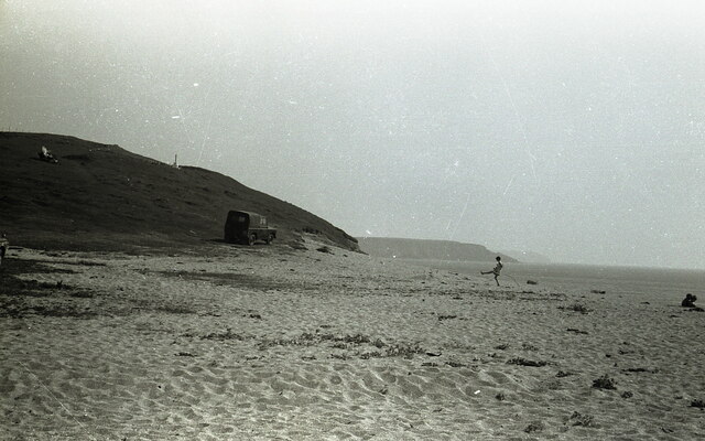
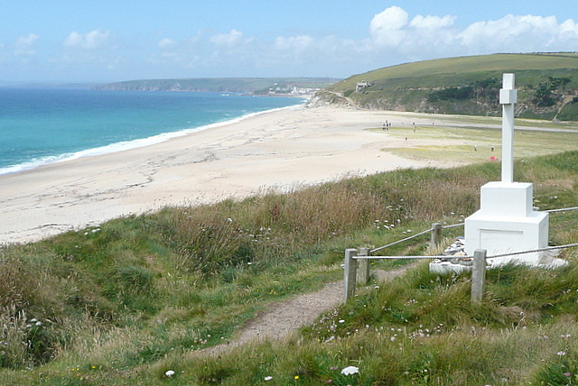
Blue Rocks is a stunning coastal feature located in Cornwall, England. It is primarily known for its picturesque headland and point, making it a popular destination for tourists and locals alike. The headland is characterized by its unique blue-hued rocks, which give the area its name.

Situated along the rugged coastline, Blue Rocks offers breathtaking views of the Atlantic Ocean. The headland juts out into the sea, providing visitors with an uninterrupted panorama of the surrounding landscape. The point, with its towering cliffs and crashing waves, adds to the dramatic beauty of the area.

Blue Rocks is not only visually captivating but also boasts a rich history. It has been a site of interest for geologists due to its distinctive rock formations and the presence of fossils dating back millions of years. The rocks themselves are composed of various minerals, giving them their striking blue coloration.

The area is also home to a diverse range of flora and fauna. Visitors can spot a variety of seabirds, such as gulls and cormorants, nesting along the cliffs. The surrounding waters are teeming with marine life, making it a popular spot for snorkeling and diving enthusiasts.

Access to Blue Rocks is relatively easy, with a well-maintained coastal path leading to the headland. However, caution is advised near the cliffs, as they can be unstable and subject to erosion.

Overall, Blue Rocks offers a captivating blend of natural beauty, geological significance, and abundant wildlife, making it a must-visit location for anyone exploring Cornwall's stunning coastline.

If you have any feedback on the listing, please let us know in the comments section below.

Blue Rocks Images

Images are sourced within 2km of 50.062676/-5.2864904 or Grid Reference SW6423. Thanks to Geograph Open Source API. All images are credited.

Direction Sign – Signpost at Chyvarloe turn in Gunwalloe parish Located on a grass triangle at Chyvarloe turn in Gunwalloe parish. 3 arms and pyramid finial. Arms all replaced since <a title="https://www.geograph.org.uk/photo/6043649" href="https://www.geograph.org.uk/photo/6043649">Link</a>. 

Milestone Society National ID: CW_SW6523
Direction Sign – Signpost at Chyvarloe turn in Gunwalloe parish
Located on a grass triangle at Chyvarloe turn in Gunwalloe parish. 3 arms and pyramid finial. Arms all replaced since Link. Milestone Society National ID: CW_SW6523
On Loe Bar With Bar Lodge in view.
On Loe Bar
With Bar Lodge in view.
On Loe Bar The HMS Anson memorial is visible on the left - as described in <a href="https://www.geograph.org.uk/photo/40910">SW6423 : H.M.S. Anson monument, Loe Bar</a>.
On Loe Bar
The HMS Anson memorial is visible on the left - as described in SW6423 : H.M.S. Anson monument, Loe Bar.
Loe Bar near Porthleven
On Loe Bar near Porthleven - view NW
Degibna Methodist Church
Carminowe Creek
Carminowe Creek
Towards Halzephron Cove The view from Halzephron Cliff towards the cove of the same name, and the eponymous house above it, which is a high quality holiday home.
Towards Halzephron Cove
The view from Halzephron Cliff towards the cove of the same name, and the eponymous house above it, which is a high quality holiday home.
Along Halzephron Cliff From above Halzephron Cove this view is along the cliff of the same name.  The coastal path says on the top, with good views seawards.  The beach here is virtually inaccessible from the land.
Along Halzephron Cliff
From above Halzephron Cove this view is along the cliff of the same name. The coastal path says on the top, with good views seawards. The beach here is virtually inaccessible from the land.
Gunwaloe Fishing Cove The house nearest to us appears to be a holiday home.  It has the Union flag flying but a German-registered car in the drive.  This is the most southerly section of the sands that go all the way to Porthleven, but are not always accessible at the Blue Rocks headland in the middle distance.
Gunwaloe Fishing Cove
The house nearest to us appears to be a holiday home. It has the Union flag flying but a German-registered car in the drive. This is the most southerly section of the sands that go all the way to Porthleven, but are not always accessible at the Blue Rocks headland in the middle distance.
House at Gunwaloe Fishing Cove This house on the cliff above the cove is being done up, perhaps to be a holiday let.  It has a stunning location above the cove and by the coastal path.
House at Gunwaloe Fishing Cove
This house on the cliff above the cove is being done up, perhaps to be a holiday let. It has a stunning location above the cove and by the coastal path.
Coastal Path near Chyvarloe A small section of the coastal path above Porthleven Sands goes through this square.  Such a small amount that this view is almost identical to Philip Halling's take on the same place a few months earlier <a href="https://www.geograph.org.uk/photo/2111778">SW6523 : Coast path above Porthleven Sands</a>
Coastal Path near Chyvarloe
A small section of the coastal path above Porthleven Sands goes through this square. Such a small amount that this view is almost identical to Philip Halling's take on the same place a few months earlier SW6523 : Coast path above Porthleven Sands
Coast at Blue Rocks Blue Rocks are to our right, and the extension of Porthleven Sands from here is called Gunwalloe Fishing Cove beach, after the hamlet at the far end of the sands.
Coast at Blue Rocks
Blue Rocks are to our right, and the extension of Porthleven Sands from here is called Gunwalloe Fishing Cove beach, after the hamlet at the far end of the sands.
Coastal path towards Loe Bar The path drops gently towards the monument, in this square, and the Low Bar, mainly in <a href="https://www.geograph.org.uk/gridref/SW6424">SW6424</a>.  The contrast between the sea, salt water, to the left, and The Loe, fresh water, to the right, is best seen from up here.
Coastal path towards Loe Bar
The path drops gently towards the monument, in this square, and the Low Bar, mainly in SW6424. The contrast between the sea, salt water, to the left, and The Loe, fresh water, to the right, is best seen from up here.
HMS Anson Monument and Loe Bar This monument commemorates the men of HMS Anson, who were drowned when the ship ran around here in 1807 and they could not get ashore.  As a result local man Henry Trengrouse invented the rock life-saving apparatus, which has prevented similar deaths.
Beyond is Loe Bar, originally an inlet to the River Loe that allowed ships to reach Helston, but subsequently partly naturally and partly man-assisted was closed off by this bar.
HMS Anson Monument and Loe Bar
This monument commemorates the men of HMS Anson, who were drowned when the ship ran around here in 1807 and they could not get ashore. As a result local man Henry Trengrouse invented the rock life-saving apparatus, which has prevented similar deaths. Beyond is Loe Bar, originally an inlet to the River Loe that allowed ships to reach Helston, but subsequently partly naturally and partly man-assisted was closed off by this bar.
The Loe and Loe Bar The River Loe used to allow ships to reach Helston, more than two miles inland.  These daysThe Loe is a freshwater lake, separated from the sea (behind us) by this shingle bar, Loe Bar.  Plants struggle to gain a foothold here, and the winter storms often bring the sea over the bar.
The Loe and Loe Bar
The River Loe used to allow ships to reach Helston, more than two miles inland. These daysThe Loe is a freshwater lake, separated from the sea (behind us) by this shingle bar, Loe Bar. Plants struggle to gain a foothold here, and the winter storms often bring the sea over the bar.
Loe Bar Porthleven Sands stretch across Loe Bar.  This area of sand and shingle dams the River Loe, that used to take ships up to Helston, two miles inland.  These days a freshwater lake, The Loe, out of shot to the left, is separated from the sea by Loe Bar.  On the north-western side this track takes the coastal path across the bar.
Loe Bar
Porthleven Sands stretch across Loe Bar. This area of sand and shingle dams the River Loe, that used to take ships up to Helston, two miles inland. These days a freshwater lake, The Loe, out of shot to the left, is separated from the sea by Loe Bar. On the north-western side this track takes the coastal path across the bar.
Show me another place!

Blue Rocks is located at Grid Ref: SW6423 (Lat: 50.062676, Lng: -5.2864904)

Unitary Authority: Cornwall

Police Authority: Devon and Cornwall

What 3 Words

///bandstand.compose.jungle. Near Porthleven, Cornwall

Related Wikis

Loe Bar Wreck

The remains of a seventeenth century cargo vessel were identified in Gunwalloe fishing cove, Cornwall in 1998. The site was designated under the Protection...

Chyvarloe

Chyvarloe is a hamlet in the parish of Gunwalloe, Cornwall, England. Chyvarloe is situated 3 miles (4.8 km) south-west of Helston on the Lizard Peninsula...

Gunwalloe

Gunwalloe ( Cornish: Pluw Wynnwalow) is a coastal civil parish in Cornwall, England, United Kingdom. It is situated on the Lizard Peninsula three miles...

Berepper

Berepper is a coastal village in south Cornwall, England, United Kingdom. It is situated on the west side of the Lizard peninsula four miles (6 km) south...

Nearby Amenities

Located within 500m of 50.062676,-5.2864904
Source: PGS
Lat/Long: 50.065459/-5.290971
Source: PGS
Lat/Long: 50.0646619/-5.2897011
Source: PGS
Lat/Long: 50.0634146/-5.288076
Source: PGS
Lat/Long: 50.0623949/-5.2869203
Source: PGS
Lat/Long: 50.061331/-5.285796
Created By: almien_coastlines
Source: PGS
Lat/Long: 50.059957/-5.283939
Bench
Backrest: no
Material: wood
Lat/Long: 50.0630925/-5.2858852
Bench
Lat/Long: 50.0602772/-5.2822247
Bench
Backrest: no
Lat/Long: 50.0635185/-5.2862722
The data included in this document is from www.openstreetmap.org. The data is made available under ODbL.

Have you been to Blue Rocks?

Leave your review of Blue Rocks below (or comments, questions and feedback).