An Gobhann
Coastal Feature, Headland, Point in Argyllshire
Scotland
An Gobhann

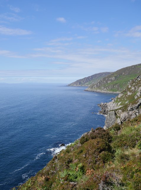
An Gobhann, also known as The Forge, is a prominent coastal feature located in Argyllshire, Scotland. It is a headland that juts out into the sea, forming a distinct point along the rugged coastline. An Gobhann offers breathtaking views of the surrounding landscape, characterized by steep cliffs, rocky shores, and the vast expanse of the Atlantic Ocean.
The headland is named after its historical association with ironworking, as the Gaelic word "gobhann" translates to "forge" in English. In the past, this area was known for its iron ore deposits, and it was a significant site for blacksmithing and metalworking. Although the ironworking industry has long ceased to exist, the name An Gobhann still pays homage to this historical legacy.
Visitors to An Gobhann can enjoy a variety of activities. The headland offers ample opportunities for hiking and walking along the stunning coastal path, which allows visitors to explore the diverse flora and fauna of the area. The rugged cliffs also provide a perfect vantage point for birdwatching, as numerous seabirds can be spotted nesting and soaring above the waves.
The surrounding waters of An Gobhann are favored by anglers, who can try their luck at catching a variety of fish species, including mackerel, cod, and pollack. Additionally, the rocky shoreline is a haven for marine life, making it a popular spot for snorkeling and diving enthusiasts.
Overall, An Gobhann is a captivating coastal feature that offers a rich blend of natural beauty, historical significance, and recreational opportunities. It is a must-visit destination for those seeking to immerse themselves in the stunning Scottish coastline.
If you have any feedback on the listing, please let us know in the comments section below.
An Gobhann Images
Images are sourced within 2km of 55.297605/-5.7867814 or Grid Reference NR5906. Thanks to Geograph Open Source API. All images are credited.


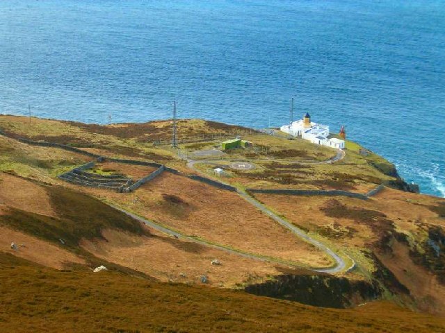
![Ruins of signal station at Tòrr na Lice Over the cliffs near Tòrr na Lice, the ruins of a semaphore signal station — Maps.nls.uk. (2022). View map: Argyll and Bute sheet CCLXIV (includes: Southend) - Ordnance Survey Six-inch 2nd and later editions, Scotland, 1892-1960. [online] Available at: <span class="nowrap"><a title="https://maps.nls.uk/view/75721327#zoom=5&amp;lat=4761&amp;lon=9667&amp;layers=BT" rel="nofollow ugc noopener" href="https://maps.nls.uk/view/75721327#zoom=5&amp;lat=4761&amp;lon=9667&amp;layers=BT">Link</a><img style="margin-left:2px;" alt="External link" title="External link - shift click to open in new window" src="https://s1.geograph.org.uk/img/external.png" width="10" height="10"/></span> [Accessed 24 May 2022].
Close to but separate from the Lower Horn House, the location for the mull of Kintyre fog horn — Canmore.org.uk. (2022). Mull Of Kintyre, Lighthouse, Lower Horn House | Canmore. [online] Available at: <span class="nowrap"><a title="https://canmore.org.uk/site/38216/mull-of-kintyre-lighthouse-lower-horn-house" rel="nofollow ugc noopener" href="https://canmore.org.uk/site/38216/mull-of-kintyre-lighthouse-lower-horn-house">Link</a><img style="margin-left:2px;" alt="External link" title="External link - shift click to open in new window" src="https://s1.geograph.org.uk/img/external.png" width="10" height="10"/></span> [Accessed 24 May 2022].
The foundations of an obvious observation shelter and the rusty base of the semaphore tower remain.
The semaphore was used for ship to shore communication on the transatlantic routes before radio telegraph to enable rapid tramsmission of progress to Lloyds of London.
](https://s2.geograph.org.uk/geophotos/07/18/11/7181174_a6f74a4b.jpg)
![Ruins of semaphore tower base Over the cliffs near Tòrr na Lice, the ruins of a semaphore signal station — Maps.nls.uk. (2022). View map: Argyll and Bute sheet CCLXIV (includes: Southend) - Ordnance Survey Six-inch 2nd and later editions, Scotland, 1892-1960. [online] Available at: <span class="nowrap"><a title="https://maps.nls.uk/view/75721327#zoom=5&amp;lat=4761&amp;lon=9667&amp;layers=BT" rel="nofollow ugc noopener" href="https://maps.nls.uk/view/75721327#zoom=5&amp;lat=4761&amp;lon=9667&amp;layers=BT">Link</a><img style="margin-left:2px;" alt="External link" title="External link - shift click to open in new window" src="https://s1.geograph.org.uk/img/external.png" width="10" height="10"/></span> [Accessed 24 May 2022].
Close to but separate from the Lower Horn House, the location for the mull of Kintyre fog horn — Canmore.org.uk. (2022). Mull Of Kintyre, Lighthouse, Lower Horn House | Canmore. [online] Available at: <span class="nowrap"><a title="https://canmore.org.uk/site/38216/mull-of-kintyre-lighthouse-lower-horn-house" rel="nofollow ugc noopener" href="https://canmore.org.uk/site/38216/mull-of-kintyre-lighthouse-lower-horn-house">Link</a><img style="margin-left:2px;" alt="External link" title="External link - shift click to open in new window" src="https://s1.geograph.org.uk/img/external.png" width="10" height="10"/></span> [Accessed 24 May 2022].
The foundations of an obvious observation shelter and the rusty base of the semaphore tower remain.
The semaphore was used for ship to shore communication on the transatlantic routes before radio telegraph to enable rapid tramsmission of progress to Lloyds of London.
](https://s0.geograph.org.uk/geophotos/07/18/11/7181180_dd1ed618.jpg)
![Foundations of signal station Over the cliffs near Tòrr na Lice, the ruins of a semaphore signal station — Maps.nls.uk. (2022). View map: Argyll and Bute sheet CCLXIV (includes: Southend) - Ordnance Survey Six-inch 2nd and later editions, Scotland, 1892-1960. [online] Available at: <span class="nowrap"><a title="https://maps.nls.uk/view/75721327#zoom=5&amp;lat=4761&amp;lon=9667&amp;layers=BT" rel="nofollow ugc noopener" href="https://maps.nls.uk/view/75721327#zoom=5&amp;lat=4761&amp;lon=9667&amp;layers=BT">Link</a><img style="margin-left:2px;" alt="External link" title="External link - shift click to open in new window" src="https://s1.geograph.org.uk/img/external.png" width="10" height="10"/></span> [Accessed 24 May 2022].
Close to but separate from the Lower Horn House, the location for the mull of Kintyre fog horn — Canmore.org.uk. (2022). Mull Of Kintyre, Lighthouse, Lower Horn House | Canmore. [online] Available at: <span class="nowrap"><a title="https://canmore.org.uk/site/38216/mull-of-kintyre-lighthouse-lower-horn-house" rel="nofollow ugc noopener" href="https://canmore.org.uk/site/38216/mull-of-kintyre-lighthouse-lower-horn-house">Link</a><img style="margin-left:2px;" alt="External link" title="External link - shift click to open in new window" src="https://s1.geograph.org.uk/img/external.png" width="10" height="10"/></span> [Accessed 24 May 2022].
The foundations of an obvious observation shelter and the rusty base of the semaphore tower remain.
The semaphore was used for ship to shore communication on the transatlantic routes before radio telegraph to enable rapid tramsmission of progress to Lloyds of London.
](https://s0.geograph.org.uk/geophotos/07/18/11/7181184_d0df0c79.jpg)
![Ruins of signal station at Tòrr na Lice Over the cliffs near Tòrr na Lice, the ruins of a semaphore signal station — Maps.nls.uk. (2022). View map: Argyll and Bute sheet CCLXIV (includes: Southend) - Ordnance Survey Six-inch 2nd and later editions, Scotland, 1892-1960. [online] Available at: <span class="nowrap"><a title="https://maps.nls.uk/view/75721327#zoom=5&amp;lat=4761&amp;lon=9667&amp;layers=BT" rel="nofollow ugc noopener" href="https://maps.nls.uk/view/75721327#zoom=5&amp;lat=4761&amp;lon=9667&amp;layers=BT">Link</a><img style="margin-left:2px;" alt="External link" title="External link - shift click to open in new window" src="https://s1.geograph.org.uk/img/external.png" width="10" height="10"/></span> [Accessed 24 May 2022].
Close to but separate from the Lower Horn House, the location for the mull of Kintyre fog horn — Canmore.org.uk. (2022). Mull Of Kintyre, Lighthouse, Lower Horn House | Canmore. [online] Available at: <span class="nowrap"><a title="https://canmore.org.uk/site/38216/mull-of-kintyre-lighthouse-lower-horn-house" rel="nofollow ugc noopener" href="https://canmore.org.uk/site/38216/mull-of-kintyre-lighthouse-lower-horn-house">Link</a><img style="margin-left:2px;" alt="External link" title="External link - shift click to open in new window" src="https://s1.geograph.org.uk/img/external.png" width="10" height="10"/></span> [Accessed 24 May 2022].
The foundations of an obvious observation shelter and the rusty base of the semaphore tower remain.
The semaphore was used for ship to shore communication on the transatlantic routes before radio telegraph to enable rapid tramsmission of progress to Lloyds of London.
](https://s0.geograph.org.uk/geophotos/07/18/11/7181188_ca7a088a.jpg)
An Gobhann is located at Grid Ref: NR5906 (Lat: 55.297605, Lng: -5.7867814)
Unitary Authority: Argyll and Bute
Police Authority: Argyll and West Dunbartonshire
What 3 Words
///fended.follow.ringside. Near Campbeltown, Argyll & Bute
Nearby Locations
Related Wikis
Mull of Kintyre
The Mull of Kintyre is the southwesternmost tip of the Kintyre Peninsula (formerly Cantyre) in southwest Scotland. From here, the Antrim coast of Northern...

1994 Mull of Kintyre Chinook crash
On 2 June 1994, a Chinook helicopter of the Royal Air Force (RAF), serial number ZD576, crashed on the Mull of Kintyre, Scotland, in foggy conditions....

St Columba's Chapel, Southend
St Columba's Chapel (Kilcomkill) is a ruined medieval chapel near Southend, Argyll and Bute, Scotland. It is noted for its carved grave slabs. == References ==
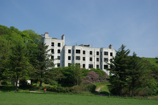
Keil Hotel
Keil Hotel is a former hotel near Southend, Kintyre in western Scotland. == History and architecture == It was constructed between 1937 and 1939 for Captain...
Nearby Amenities
Located within 500m of 55.297605,-5.7867814Have you been to An Gobhann?
Leave your review of An Gobhann below (or comments, questions and feedback).