Carraig Eilc

Coastal Feature, Headland, Point in Argyllshire

Scotland

Carraig Eilc

Kilfinichen Church, Isle of Mull
Kilfinichen Church, Isle of Mull Credit: J M Briscoe

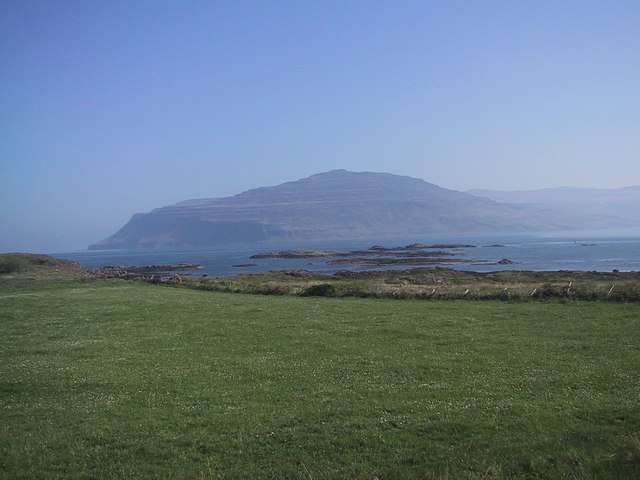
Carraig Eilc is a prominent coastal feature located in Argyllshire, Scotland. It is a headland that extends into the Atlantic Ocean, forming a distinct point along the rugged coastline. The name "Carraig Eilc" translates to "rocky place" in Gaelic, which accurately reflects the nature of this geographical feature.

The headland is characterized by its towering cliffs, which rise dramatically from the sea. These cliffs are composed of ancient rock formations, displaying layers of sediment and minerals that have been shaped by centuries of erosion. Carraig Eilc stands as a testament to the powerful forces of nature and offers breathtaking panoramic views of the surrounding ocean.

The headland serves as a natural barrier, protecting the nearby coastal areas from the full force of the Atlantic waves. It acts as a buffer against erosion and provides a haven for a diverse array of marine life. The surrounding waters are teeming with fish, making Carraig Eilc a popular spot for fishing enthusiasts.

Additionally, Carraig Eilc is a haven for birdwatchers, as it provides nesting grounds for a variety of seabirds. Visitors can spot species such as gannets, puffins, and guillemots perched on the cliffs or soaring above the waves.

Due to its striking natural beauty and ecological significance, Carraig Eilc also attracts tourists who come to explore the area's coastal trails and enjoy the breathtaking scenery. The headland offers a peaceful retreat away from bustling urban life, allowing visitors to connect with nature and experience the mesmerizing power of the ocean firsthand.

If you have any feedback on the listing, please let us know in the comments section below.

Carraig Eilc Images

Images are sourced within 2km of 56.390536/-6.0365801 or Grid Reference NM5029. Thanks to Geograph Open Source API. All images are credited.

Kilfinichen Church, Isle of Mull
Loch Scridain
Loch Scridain
Backshore near Aird Chill Fhinichin Photographer is located at a point not far from the church.
Backshore near Aird Chill Fhinichin
Photographer is located at a point not far from the church.
View from Eilean a' Ghaill Today was one of those days of stunning clarity and I was lucky enough to be on Mull and took this view. The head of Loch Scridain, or Kinloch, can be seen beyond the solitary tree on Eilean a' Ghaill.
View from Eilean a' Ghaill
Today was one of those days of stunning clarity and I was lucky enough to be on Mull and took this view. The head of Loch Scridain, or Kinloch, can be seen beyond the solitary tree on Eilean a' Ghaill.
Floral tributes at Mull Rally 2015 At 1.10 p.m. on Saturday, 10th October 2015, a competing car left the road at this point during a special stage of the 2015 Mull Rally. The co-driver was killed in the crash. The rally was cancelled very soon after this tragic accident.
Floral tributes at Mull Rally 2015
At 1.10 p.m. on Saturday, 10th October 2015, a competing car left the road at this point during a special stage of the 2015 Mull Rally. The co-driver was killed in the crash. The rally was cancelled very soon after this tragic accident.
Cattle above Loch Scridain Cattle beside the B8035 above Loch Scridain and along from Killiemore House.
Cattle above Loch Scridain
Cattle beside the B8035 above Loch Scridain and along from Killiemore House.
Tree beside the B8073
Converted church by junction on the B8073
Benchmark by Loch Scridain The OS description is RIVET TOP S PARA BR 2.8M SW C STR. There is a fine view across Loch Scridain as the Allt na Coille Moire flows into it.
Benchmark by Loch Scridain
The OS description is RIVET TOP S PARA BR 2.8M SW C STR. There is a fine view across Loch Scridain as the Allt na Coille Moire flows into it.
Benchmark on a church There is a cut benchmark <a href="https://www.geograph.org.uk/photo/5460991">NM4928 : Benchmark over the wall</a> on this building, described in the OS database as a church but now a private house. The single-track B8035 leads eventually to the Craignure to Iona ferry road, the A849.
Benchmark on a church
There is a cut benchmark NM4928 : Benchmark over the wall on this building, described in the OS database as a church but now a private house. The single-track B8035 leads eventually to the Craignure to Iona ferry road, the A849.
Benchmark over the wall The benchmark is on the wall facing the camera <a href="https://www.geograph.org.uk/photo/5460985">NM4928 : Benchmark on a church</a>, but a low wall has been built since the building was a church, so you have to peer over it to see the mark: CH SE RD JUNC 1.2M N ANG NW FACE.
Benchmark over the wall
The benchmark is on the wall facing the camera NM4928 : Benchmark on a church, but a low wall has been built since the building was a church, so you have to peer over it to see the mark: CH SE RD JUNC 1.2M N ANG NW FACE.
Loch Beg The shoreline of Loch Beg. Seen across the loch is Kinloch hotel.
Loch Beg
The shoreline of Loch Beg. Seen across the loch is Kinloch hotel.
Killiemore Farm Old buildings at Killiemore Farm .
Killiemore Farm
Old buildings at Killiemore Farm .
Killiemore Steading The old steading at Killiemore Farm looking as if it's seen its best days.
Killiemore Steading
The old steading at Killiemore Farm looking as if it's seen its best days.
Old Milepost by the B8035, Kilfinichen Bay Blaydon casting by the B8035, in parish of Kilfinichen & Kilvickeon (Mull District), Kilfinichen Bay, overlooking bay.

Inscription reads:-
: SALEN / 16 : : 1897 : : IONA FERRY / 22 :
Maker:-
: SMITH PATTERSON / BLAYDON : 

Surveyed

Milestone Society National ID: AB_MLSAIF16
Old Milepost by the B8035, Kilfinichen Bay
Blaydon casting by the B8035, in parish of Kilfinichen & Kilvickeon (Mull District), Kilfinichen Bay, overlooking bay. Inscription reads:- : SALEN / 16 : : 1897 : : IONA FERRY / 22 : Maker:- : SMITH PATTERSON / BLAYDON : Surveyed Milestone Society National ID: AB_MLSAIF16
Shore of Loch Scridain  below Dererach Dererach is the isolated house seen at the centre of the image, The B8035 passes in front of it.
Maol na Coille Mòire is the hill top above the trees.
Shore of Loch Scridain below Dererach
Dererach is the isolated house seen at the centre of the image, The B8035 passes in front of it. Maol na Coille Mòire is the hill top above the trees.
SW slopes of Ben More Looking down the wet grassy slopes to forestry and Loch Scridain
SW slopes of Ben More
Looking down the wet grassy slopes to forestry and Loch Scridain
Thatched cottage at Kilfinichen On the shore Kilfinichen Bay, part of Loch Scridain, and available for holiday letting.
Thatched cottage at Kilfinichen
On the shore Kilfinichen Bay, part of Loch Scridain, and available for holiday letting.
Show me another place!

Carraig Eilc is located at Grid Ref: NM5029 (Lat: 56.390536, Lng: -6.0365801)

Unitary Authority: Argyll and Bute

Police Authority: Argyll and West Dunbartonshire

What 3 Words

///airtime.latched.investors. Near Lochbuie, Argyll & Bute

Nearby Locations

Carraig Eilc

Related Wikis

Aird of Kinloch

Aird of Kinloch (Gaelic:An Àird) is a rocky outcrop between Loch Scridain and Loch Beg on the Isle of Mull, Argyll and Bute, Scotland. == References ==

Pennyghael

Pennyghael (Scottish Gaelic: Peighinn nan Gàidheal) is a small village in the Ross of Mull, Argyll and Bute, Scotland. It is located along the A849 road...

Tiroran

Tiroran is hamlet on the Isle of Mull in Argyll and Bute, Scotland. == History == In the late 18th century Tiroran House was associated with the McKinnon...

Loch Scridain

Loch Scridain is a 15-kilometre-long (9-mile) sea loch, with a west-south west aspect, on the western, or Atlantic coastline of the Isle of Mull, in the...

Nearby Amenities

Located within 500m of 56.390536,-6.0365801
Source: PGS
Lat/Long: 56.3917991/-6.0333006
Passing Place
Lat/Long: 56.3926259/-6.0325975
Power: pole
Lat/Long: 56.3892858/-6.0420741
Power: pole
Lat/Long: 56.389876/-6.0407075
Power: pole
Lat/Long: 56.3902435/-6.0397714
Power: pole
Lat/Long: 56.3908039/-6.038433
Power: pole
Lat/Long: 56.3913874/-6.0370141
Power: pole
Lat/Long: 56.3919857/-6.0355859
Power: pole
Lat/Long: 56.3926159/-6.0340825
Power: pole
Lat/Long: 56.3932328/-6.0326073
Power: pole
Lat/Long: 56.3935676/-6.0310596
The data included in this document is from www.openstreetmap.org. The data is made available under ODbL.

Have you been to Carraig Eilc?

Leave your review of Carraig Eilc below (or comments, questions and feedback).