Bohenuil Trodday

Coastal Feature, Headland, Point in Inverness-shire

Scotland

Bohenuil Trodday

Eilean Trodday The hills of Harris are visible, very faintly, on the horizon.
Eilean Trodday Credit: David Purchase

Bohenuil Trodday is a prominent coastal feature located in Inverness-shire, Scotland. It is a headland that juts out into the North Atlantic Ocean, offering breathtaking views of the surrounding landscape. The headland is situated near the small village of Bohenuil, which is known for its picturesque charm and scenic beauty.

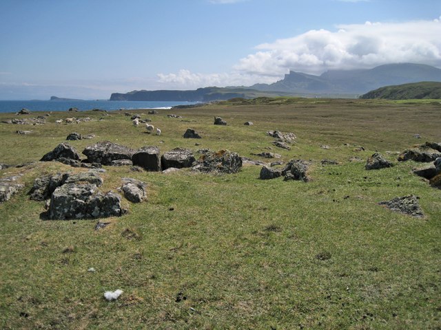
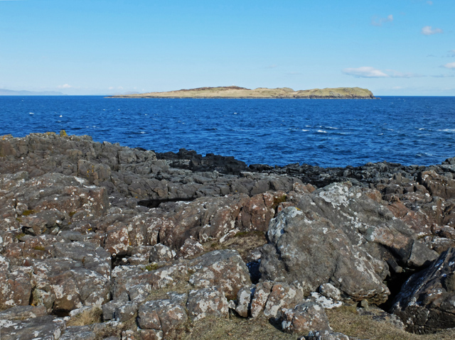
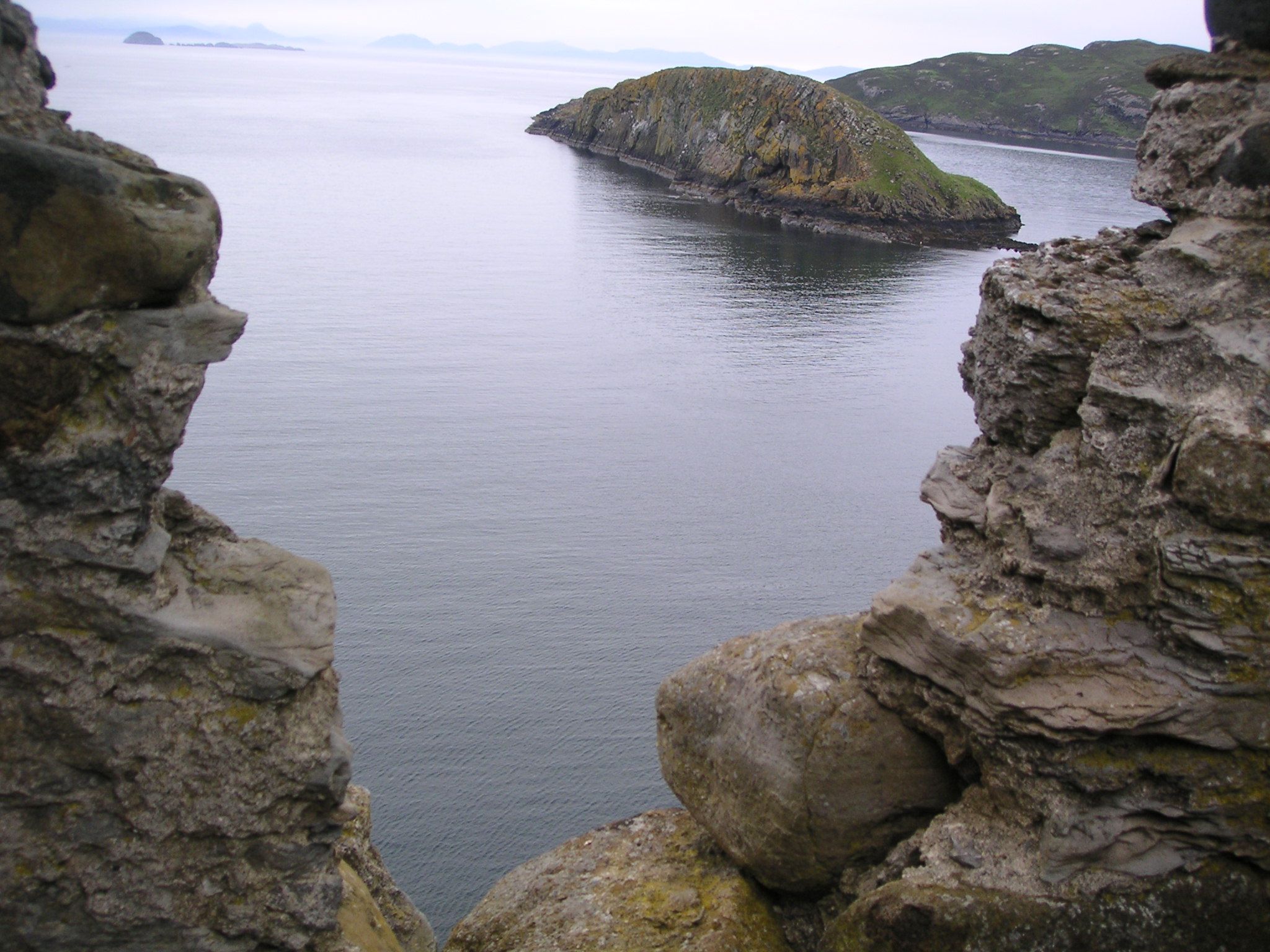
Bohenuil Trodday is characterized by its rugged cliffs, which rise steeply from the sea, creating a dramatic and awe-inspiring vista. The headland is composed of rocky outcrops and is covered in lush vegetation, including grasses, heather, and wildflowers. This diverse flora provides a habitat for various bird species, making it a popular spot for birdwatchers.

The headland is also home to a small sandy beach, nestled between the cliffs. This secluded beach offers a tranquil and peaceful setting, perfect for relaxation and enjoying the sound of crashing waves. It is an ideal spot for picnics, sunbathing, and exploring the nearby rock pools.

Bohenuil Trodday is a haven for outdoor enthusiasts, with many walking trails and hiking routes crisscrossing the headland. These paths provide visitors with the opportunity to explore the rugged coastline and enjoy panoramic views of the ocean. The area is also famous for its wildlife, including seals, dolphins, and various seabirds, adding to the natural beauty and charm of the location.

Overall, Bohenuil Trodday is a stunning coastal feature that offers visitors a unique and unforgettable experience. Its majestic cliffs, sandy beach, and diverse wildlife make it a must-visit destination for nature lovers and adventure seekers alike.

If you have any feedback on the listing, please let us know in the comments section below.

Bohenuil Trodday Images

Images are sourced within 2km of 57.722697/-6.3016048 or Grid Reference NG4378. Thanks to Geograph Open Source API. All images are credited.

Eilean Trodday The hills of Harris are visible, very faintly, on the horizon.
Eilean Trodday
The hills of Harris are visible, very faintly, on the horizon.
Paddling over a reef off the north of Skye A sea kayak trip from Staffin round the Trotternish peninsula to Port Duntulm via the exposed headland of Rubha Hunish offers some exciting headlands with tide races. Between the more exposed points, one finds interest in paddling over and between rocks, lifted by the swell. Here, after passing Rubha Bheanachain at the start of the exposed section, and Rubha na-h-Aiseig to reach the northern coast, we are in a bit of an embayment out of the main tidal flow with one more section of caves and arches to explore before the tide rushes us past Rubha Hunish in the trip's culmination.
Paddling over a reef off the north of Skye
A sea kayak trip from Staffin round the Trotternish peninsula to Port Duntulm via the exposed headland of Rubha Hunish offers some exciting headlands with tide races. Between the more exposed points, one finds interest in paddling over and between rocks, lifted by the swell. Here, after passing Rubha Bheanachain at the start of the exposed section, and Rubha na-h-Aiseig to reach the northern coast, we are in a bit of an embayment out of the main tidal flow with one more section of caves and arches to explore before the tide rushes us past Rubha Hunish in the trip's culmination.
Rubh 'an t-Sailleir Part of the rocky shoreline north of The Aird close to the most northerly tip of the isle of Skye. The island is Trodday.
Rubh 'an t-Sailleir
Part of the rocky shoreline north of The Aird close to the most northerly tip of the isle of Skye. The island is Trodday.
A surprise fence There are high, usually un-fenced cliffs round the coast of much of the Isle of Skye, so it comes as a bit of a surprise to find a sturdy fence here, north of The Aird, with only a relatively gentle slope to the shore below. Beyond is the Hunish peninsula.
A surprise fence
There are high, usually un-fenced cliffs round the coast of much of the Isle of Skye, so it comes as a bit of a surprise to find a sturdy fence here, north of The Aird, with only a relatively gentle slope to the shore below. Beyond is the Hunish peninsula.
Rubha na h-Aiseig Looking over heather moorland and the bay named Lùb Stac nam Meann to the second-most northerly point on the Isle of Skye.
Rubha na h-Aiseig
Looking over heather moorland and the bay named Lùb Stac nam Meann to the second-most northerly point on the Isle of Skye.
Ruins above the shore Looking down from the hillside above, it is clear that there are three unroofed but substantially complete ruined buildings amid the heather and bracken just above the shore of Lùb Stac nam Meann.
Ruins above the shore
Looking down from the hillside above, it is clear that there are three unroofed but substantially complete ruined buildings amid the heather and bracken just above the shore of Lùb Stac nam Meann.
Beach and ruins above Lùb Stac nam Meann A small flock of sheep is grazing around the ruins.
Beach and ruins above Lùb Stac nam Meann
A small flock of sheep is grazing around the ruins.
Boulder beach above Lùb Stac nam Meann The beach is made up of rounded boulders, none of them small enough to be described as pebbles.
Boulder beach above Lùb Stac nam Meann
The beach is made up of rounded boulders, none of them small enough to be described as pebbles.
Rubha na h-Aiseig This is the seldom-visited north eastern tip of the Trotternish Peninsula. The low headland jutting into the sea in the centre of the picture is Rubha Hunish, a far more popular spot to visit, being the most northerly tip of the Isle of Skye.
Rubha na h-Aiseig
This is the seldom-visited north eastern tip of the Trotternish Peninsula. The low headland jutting into the sea in the centre of the picture is Rubha Hunish, a far more popular spot to visit, being the most northerly tip of the Isle of Skye.
South from Rubha na h-Aiseig This flat, low-lying piece of land, which is boggy away from the shore, lies to the east of Ben Volovaig. The northern end of the Trotternish Ridge hides under cloud on the right. Eilean Flodigarry is visible on the horizon on the left.
South from Rubha na h-Aiseig
This flat, low-lying piece of land, which is boggy away from the shore, lies to the east of Ben Volovaig. The northern end of the Trotternish Ridge hides under cloud on the right. Eilean Flodigarry is visible on the horizon on the left.
Rocky shore at Rubha na h-Aiseig Not a place I would wish to be standing in a north westerly gale.
Rocky shore at Rubha na h-Aiseig
Not a place I would wish to be standing in a north westerly gale.
Over Rubha na h-Aiseig to Eilean Trodday The nearest part of the small island is in grid square <a href="https://www.geograph.org.uk/gridref/NG4478">NG4478</a>. There is a lighthouse on the island, which was visible from where this picture was taken, but does not show up in my photograph.
Over Rubha na h-Aiseig to Eilean Trodday
The nearest part of the small island is in grid square NG4478. There is a lighthouse on the island, which was visible from where this picture was taken, but does not show up in my photograph.
North east from the northern slope of Ben Volovaig Looking out over Rubha na h-Aiseig with a little of Eilean Trodday just visible on the left. The tiny white triangle in the sea is the sail of a passing yacht.
North east from the northern slope of Ben Volovaig
Looking out over Rubha na h-Aiseig with a little of Eilean Trodday just visible on the left. The tiny white triangle in the sea is the sail of a passing yacht.
Eilean Trodday The island off the north coast of Skye, seen from Hunish.
The lighthouse on the top is in <a href="https://www.geograph.org.uk/gridref/NG4478">NG4478</a>
Eilean Trodday
The island off the north coast of Skye, seen from Hunish. The lighthouse on the top is in NG4478
Sentinel A quite phallic rock similar to many named Buachaille (herdsman) along the west Highland coast.  I don't know whether this one has a name of its own.
Sentinel
A quite phallic rock similar to many named Buachaille (herdsman) along the west Highland coast. I don't know whether this one has a name of its own.
A corner of Trodday Rocks meet the sea; in the background is northern Skye and An t-Iasgair.
A corner of Trodday
Rocks meet the sea; in the background is northern Skye and An t-Iasgair.
Lùb Stac nam Meann A small bay in the northeast of Skye. Harris and Lewis are visible on the horizon.
Lùb Stac nam Meann
A small bay in the northeast of Skye. Harris and Lewis are visible on the horizon.
Rubha na h-Aiseig Ferry Point, the northeastern extremity of Skye. Eilean Trodday is on the horizon.
Rubha na h-Aiseig
Ferry Point, the northeastern extremity of Skye. Eilean Trodday is on the horizon.
Show me another place!

Bohenuil Trodday is located at Grid Ref: NG4378 (Lat: 57.722697, Lng: -6.3016048)

Unitary Authority: Highland

Police Authority: Highlands and Islands

What 3 Words

///surcharge.ripen.earful. Near Uig, Highland

Related Wikis

Eilean Trodday

Eilean Trodday is an island in The Minch just off the north coast of the Trotternish peninsula of Skye in Scotland. Eilean Trodday is about 38 hectares...

Kilmaluag

Kilmaluag (Scottish Gaelic: Cill Moluaig, meaning St. Moluag's Cell, Church or Chapel) is a township made up of several small settlements on the most northerly...

Duntulm

Duntulm (Scottish Gaelic: Dùn Thuilm) is a township on the most northerly point of the Trotternish peninsula of the Isle of Skye made up of Shulista (north...
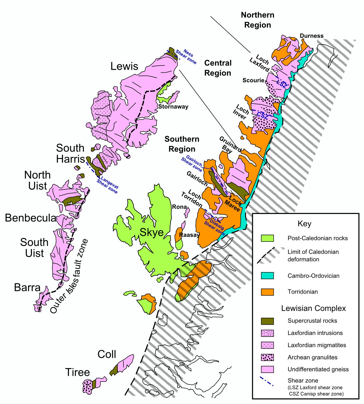
Hebridean Terrane

The Hebridean Terrane is one of the terranes that form part of the Caledonian orogenic belt in northwest Scotland. Its boundary with the neighbouring Northern...

Nearby Amenities

Located within 500m of 57.722697,-6.3016048
Source: PGS
Lat/Long: 57.7221466/-6.2935993
Source: PGS
Lat/Long: 57.7227338/-6.2944928
Source: PGS
Lat/Long: 57.72283/-6.2949755
Source: PGS
Lat/Long: 57.7225782/-6.2954221
Source: PGS
Lat/Long: 57.7229287/-6.2959677
Source: PGS
Lat/Long: 57.7229491/-6.2962481
Source: PGS
Lat/Long: 57.7227429/-6.2989122
Source: PGS
Lat/Long: 57.7229148/-6.299864
Source: PGS
Lat/Long: 57.7229604/-6.3005106
Source: PGS
Lat/Long: 57.7233182/-6.3007506
Source: PGS
Lat/Long: 57.7233872/-6.3009778
Source: PGS
Lat/Long: 57.723102/-6.3014104
Source: PGS
Lat/Long: 57.7235388/-6.3022714
Source: PGS
Lat/Long: 57.7235358/-6.3029238
Source: PGS
Lat/Long: 57.7237601/-6.3032328
Source: PGS
Lat/Long: 57.7241989/-6.3035308
Source: PGS
Lat/Long: 57.7240589/-6.3039662
Source: PGS
Lat/Long: 57.7244608/-6.3049819
Source: PGS
Lat/Long: 57.7251001/-6.3054322
Source: PGS
Lat/Long: 57.7251458/-6.3061203
Source: PGS
Lat/Long: 57.7259257/-6.3063963
Eilean Trodday
Place: locality
Lat/Long: 57.7257082/-6.2987281
The data included in this document is from www.openstreetmap.org. The data is made available under ODbL.

Have you been to Bohenuil Trodday?

Leave your review of Bohenuil Trodday below (or comments, questions and feedback).