Sloc nam Fiùran

Coastal Feature, Headland, Point in Argyllshire

Scotland

Sloc nam Fiùran

Marshy ground below the B8035 near An Sithean Looking towards a farmstead at Balmeanach in square <a href="https://www.geograph.org.uk/gridref/NM4433">NM4433</a>.
Marshy ground below the B8035 near An Sithean Credit: Rod Allday

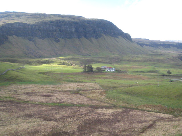
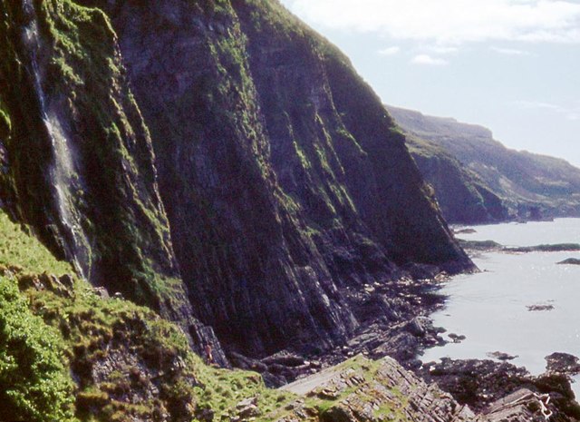
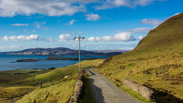
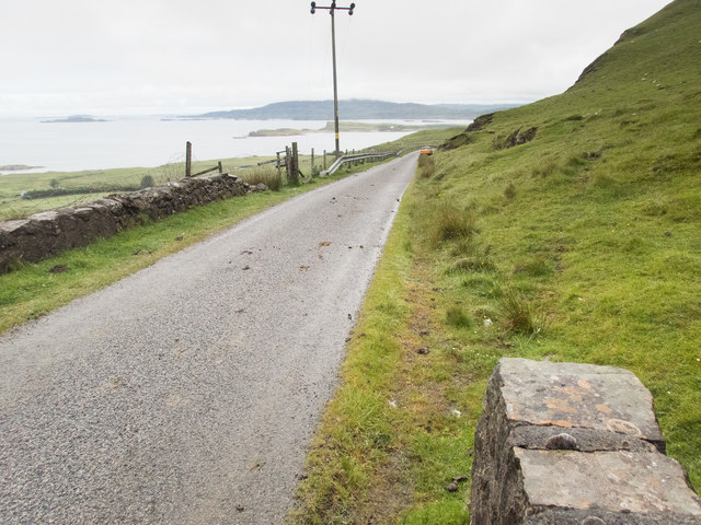
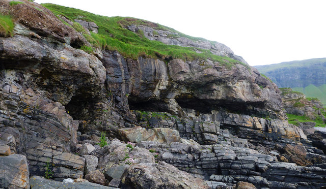
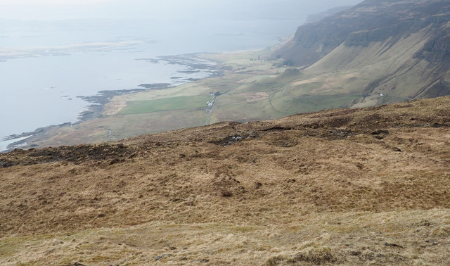
Sloc nam Fiùran is a stunning coastal feature located in Argyllshire, Scotland. It is a prominent headland or point that juts out into the Atlantic Ocean, offering breathtaking views and a rugged, picturesque landscape.

Situated on the west coast of Scotland, Sloc nam Fiùran is known for its dramatic cliffs and rocky shoreline. The headland is characterized by its tall, steep cliffs that plunge into the sea, creating a striking contrast against the deep blue waters below. The rugged terrain is a result of thousands of years of erosion by the powerful Atlantic waves, which have carved out caves, arches, and stacks along the coastline.

The area surrounding Sloc nam Fiùran is rich in wildlife and natural beauty. It is home to a diverse range of plant and animal species, including seabirds, seals, and even dolphins. Visitors can often spot these creatures while exploring the headland, making it a haven for nature enthusiasts and birdwatchers.

For those seeking adventure, Sloc nam Fiùran offers opportunities for hiking and rock climbing, with its challenging terrain providing a thrilling experience for outdoor enthusiasts. The headland is also a popular spot for photographers, who are drawn to the dramatic scenery and the interplay of light and shadows.

Overall, Sloc nam Fiùran is a captivating coastal feature that showcases the raw beauty of the Scottish coastline. Its towering cliffs, abundant wildlife, and stunning vistas make it a must-visit destination for nature lovers and those seeking an authentic Scottish experience.

If you have any feedback on the listing, please let us know in the comments section below.

Sloc nam Fiùran Images

Images are sourced within 2km of 56.412532/-6.1527142 or Grid Reference NM4332. Thanks to Geograph Open Source API. All images are credited.

Marshy ground below the B8035 near An Sithean Looking towards a farmstead at Balmeanach in square <a href="https://www.geograph.org.uk/gridref/NM4433">NM4433</a>.
Marshy ground below the B8035 near An Sithean
Looking towards a farmstead at Balmeanach in square NM4433.
Sea cliffs at Mackinnon's Cave
Start of the downhill section of the B8073 to Loch na Keal
In the hairpins on the B8035
Coastal road on Mull There are a number of images taken along the Allt na Teangaidh, eg <a href="https://www.geograph.org.uk/photo/4388391">NM4532 : Allt na Teangaidh</a>. This bridge, with a rivet benchmark <a href="https://www.geograph.org.uk/photo/5461761">NM4532 : Benchmark on a bridge parapet</a> at the end of the parapet, is over an unnamed tributary flowing from the cliffs of A Mhaol. The view is along the A8035 (which runs out of the square in about 150m) to the small island of Inch Kenneth and the larger island of Ulva beyond.
Coastal road on Mull
There are a number of images taken along the Allt na Teangaidh, eg NM4532 : Allt na Teangaidh. This bridge, with a rivet benchmark NM4532 : Benchmark on a bridge parapet at the end of the parapet, is over an unnamed tributary flowing from the cliffs of A Mhaol. The view is along the A8035 (which runs out of the square in about 150m) to the small island of Inch Kenneth and the larger island of Ulva beyond.
Benchmark on a bridge parapet The OS description is NBM RIVET NE PARA BR NW END. The bridge parapet and the view from it are shown in <a href="https://www.geograph.org.uk/photo/5461757">NM4532 : Coastal road on Mull</a>.
Benchmark on a bridge parapet
The OS description is NBM RIVET NE PARA BR NW END. The bridge parapet and the view from it are shown in NM4532 : Coastal road on Mull.
Buried landscape on the Gribun coast In Scotland where one is so used to seeing younger rocks thrust over older ones by the dramatic (if long drawn out) collision of continents, it's good to find a classic unconformity where the younger rocks (in this case Triassic conglomerates) were laid down over the top of an existing, ancient landscape. The lower rocks (grey, layered, fine-grained) are Psammites of the Moine Series - ancient impure sandstones metamorphosed by heat and pressure, then raised to the surface and eroded. They formed shoreline rocks as the sea covered them and deposited sand and pebbles which, with deeper burial, became the conglomerate rock you see above the eroded caves and below the grass. The uneven boundary between the two rock types shows the shape of the rocky shore before its burial. More recently again, in Tertiary times, as Europe and North America started to separate, the whole lot was buried deeper by lava flows.  Erosion works constantly, and here they all are again exposed to view as the sea cuts away the land, leaving scattered boulders not only of the conglomerate and the psammite, but also of the basalt from the cliffs seen in the distance.
Buried landscape on the Gribun coast
In Scotland where one is so used to seeing younger rocks thrust over older ones by the dramatic (if long drawn out) collision of continents, it's good to find a classic unconformity where the younger rocks (in this case Triassic conglomerates) were laid down over the top of an existing, ancient landscape. The lower rocks (grey, layered, fine-grained) are Psammites of the Moine Series - ancient impure sandstones metamorphosed by heat and pressure, then raised to the surface and eroded. They formed shoreline rocks as the sea covered them and deposited sand and pebbles which, with deeper burial, became the conglomerate rock you see above the eroded caves and below the grass. The uneven boundary between the two rock types shows the shape of the rocky shore before its burial. More recently again, in Tertiary times, as Europe and North America started to separate, the whole lot was buried deeper by lava flows. Erosion works constantly, and here they all are again exposed to view as the sea cuts away the land, leaving scattered boulders not only of the conglomerate and the psammite, but also of the basalt from the cliffs seen in the distance.
Balmeanach Farm Creag a' Ghaill is beyond the farm.
Balmeanach Farm
Creag a' Ghaill is beyond the farm.
Small cove near Mackinnon's Cave Apparently unnamed cove, SW of the cave and below the west end of Creag a' Ghaill. The Allt an Ath Dheirg enters the sea here.
Out to sea are Erisgeir (centre) with Staffa and the Dutchman's Cap aligned (centre right).
Small cove near Mackinnon's Cave
Apparently unnamed cove, SW of the cave and below the west end of Creag a' Ghaill. The Allt an Ath Dheirg enters the sea here. Out to sea are Erisgeir (centre) with Staffa and the Dutchman's Cap aligned (centre right).
Allt na Teangaidh The Allt na Teangaidh close to the B8035 flowing north, soon to enter a steepening slot along its course, passing the eastern end of the rocks of Creag a' Ghaill before entering Loch na Keal.
Allt na Teangaidh
The Allt na Teangaidh close to the B8035 flowing north, soon to enter a steepening slot along its course, passing the eastern end of the rocks of Creag a' Ghaill before entering Loch na Keal.
Gravelly material on north side of Beinn na h-Iolaire There are extensive areas of this granular, earthy/gravelly material on Beinn na h-Iolaire. Similar areas are found on nearby hills to the south, Beinn na Srèine and Maol Mhèadhonach. In this area there are 'pegs', (tubes actually), set into the surface of the material; it's likely they were placed to assess the rate of erosion of the surface which must occur by wind and water. For a similar example (without tubes), see <a title="https://www.geograph.org.uk/photo/5742073" href="https://www.geograph.org.uk/photo/5742073">Link</a> .
Gravelly material on north side of Beinn na h-Iolaire
There are extensive areas of this granular, earthy/gravelly material on Beinn na h-Iolaire. Similar areas are found on nearby hills to the south, Beinn na Srèine and Maol Mhèadhonach. In this area there are 'pegs', (tubes actually), set into the surface of the material; it's likely they were placed to assess the rate of erosion of the surface which must occur by wind and water. For a similar example (without tubes), see Link .
Moorland on Beinn na h-Iolaire The moorland is on the broad, north-west ridge of Beinn na h-Iolaire.
Beyond are the hills Fionna Mhàm, nearer the camera, and Creach-Bheinn.
Moorland on Beinn na h-Iolaire
The moorland is on the broad, north-west ridge of Beinn na h-Iolaire. Beyond are the hills Fionna Mhàm, nearer the camera, and Creach-Bheinn.
Slope descending towards Creag a' Ghaill There's little clue in the image but just beyond the limit of the foreground slope there's terrific verticality in the form of a high cliff - Creag a' Ghaill; Alex Nelson's photograph shows it well - <a title="https://www.geograph.org.uk/photo/521227" href="https://www.geograph.org.uk/photo/521227">Link</a>.
The sea below is Loch na Keal with the island, Inch Kenneth seen dimly offshore.
Slope descending towards Creag a' Ghaill
There's little clue in the image but just beyond the limit of the foreground slope there's terrific verticality in the form of a high cliff - Creag a' Ghaill; Alex Nelson's photograph shows it well - Link. The sea below is Loch na Keal with the island, Inch Kenneth seen dimly offshore.
B8035 crossing slope above Balmeanach Balmeanach is an area of farmed land close to Loch na Keal; it lies below the slope largely out of view in the image. The B8035 continues around the corner climbing to cross a pass before descending to the shore of Loch Scridain.
B8035 crossing slope above Balmeanach
Balmeanach is an area of farmed land close to Loch na Keal; it lies below the slope largely out of view in the image. The B8035 continues around the corner climbing to cross a pass before descending to the shore of Loch Scridain.
Balmeanach The farm at Balmeanach is served by its own minor road branching from the B8035.
The impressive rock band in the distance is Creag a' Ghaill.
Balmeanach
The farm at Balmeanach is served by its own minor road branching from the B8035. The impressive rock band in the distance is Creag a' Ghaill.
The descent from Beinn na Srèine Heading west along the ridgewalk from Beinn na Srèine one walks the top of a lava flow which ends abruptly in these basalt crags. Basalt is dark grey to black when first exposed, but weathers to this characteristic rusty colour owing the high content of iron-rich mafic minerals. The whole area is characterised by its orange rock architecture. A reasonably good (though essentially pathless) route descends the grassy drainage from the right of the photo to the col, Eag Fionna Mhàm, from which the photo was taken.
The descent from Beinn na Srèine
Heading west along the ridgewalk from Beinn na Srèine one walks the top of a lava flow which ends abruptly in these basalt crags. Basalt is dark grey to black when first exposed, but weathers to this characteristic rusty colour owing the high content of iron-rich mafic minerals. The whole area is characterised by its orange rock architecture. A reasonably good (though essentially pathless) route descends the grassy drainage from the right of the photo to the col, Eag Fionna Mhàm, from which the photo was taken.
Creag a' Ghaill High cliffs over the low coastal plain by Balmeanach.
Creag a' Ghaill
High cliffs over the low coastal plain by Balmeanach.
Sheiling Land  above Creag a' Ghaill The plateau behind Creag a' Ghaill rising towards Beinn na h-Iolaire. This land was used as summer sheiling grazing in the past.
Sheiling Land above Creag a' Ghaill
The plateau behind Creag a' Ghaill rising towards Beinn na h-Iolaire. This land was used as summer sheiling grazing in the past.
Show me another place!

Sloc nam Fiùran is located at Grid Ref: NM4332 (Lat: 56.412532, Lng: -6.1527142)

Unitary Authority: Argyll and Bute

Police Authority: Argyll and West Dunbartonshire

What 3 Words

///skips.mystery.blueberry. Near Fionnphort, Argyll & Bute

Related Wikis

Ardmeanach

Ardmeanach in modern times refers to a peninsula on the Isle of Mull. It is the middle one out of three westward-facing peninsulas on the island, and the...

St Kenneth's Chapel

St. Kenneth's Chapel is a ruined chapel on Inch Kenneth Island, Parish of Kilfinichen and Kilvickeon, Isle of Mull, Argyll and Bute, Scotland. It dates...

Inch Kenneth

Inch Kenneth (Scottish Gaelic: Innis Choinnich) is a small grassy island off the west coast of the Isle of Mull, in Scotland. It is at the entrance of...

Samalan Island

Samalan Island is a small island, just off the Isle of Mull at the mouth of Loch na Keal in the Inner Hebrides, Scotland. To its south west is the island...

Have you been to Sloc nam Fiùran?

Leave your review of Sloc nam Fiùran below (or comments, questions and feedback).