An Garbh-ard

Coastal Feature, Headland, Point in Argyllshire

Scotland

An Garbh-ard

Coll - Arinagour - View from rear of Coll Hotel Looking across Loch Eatharna from the helipad at the back of the Coll Hotel to the many islets in the bay and, on the far left, part of the main island of Coll. The main islet seen at centre is Eilean Eatharna.
The hotel is situated in the village of Arinagour, the chief settlement on the Isle of Coll.
Coll - Arinagour - View from rear of Coll Hotel Credit: Rob Farrow

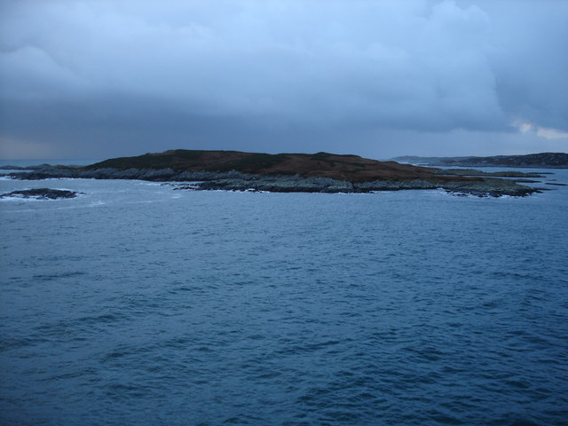
An Garbh-ard is a prominent headland located in Argyllshire, Scotland. Situated along the rugged coastline, it is known for its stunning natural beauty and dramatic views of the surrounding landscape. The headland extends out into the sea, forming a distinctive point that juts out into the water.

The name "An Garbh-ard" translates to "the rough height" in Gaelic, which aptly describes the character of this coastal feature. It is characterized by steep cliffs that rise up from the water, creating a striking visual contrast between the deep blue sea and the rocky terrain. The cliffs are composed of rugged rock formations, shaped by the forces of erosion over thousands of years.

The headland is home to a diverse range of flora and fauna, with various species of seabirds nesting along the cliffs. Visitors to An Garbh-ard can witness the spectacular sight of these birds soaring through the air or perched on the rocky ledges.

Due to its exposed location, An Garbh-ard is often subject to strong winds and crashing waves, adding to its wild and untamed allure. The turbulent waters surrounding the headland make it a popular spot for experienced surfers and other water sports enthusiasts seeking an adrenaline rush.

In addition to its natural beauty, An Garbh-ard also holds historical significance. The area is dotted with ancient ruins, including the remains of a medieval castle perched on top of the headland. These remnants provide a glimpse into the rich history and heritage of the region.

Overall, An Garbh-ard is a breathtaking coastal feature that offers visitors a chance to experience the rugged beauty of Scotland's coastline while immersing themselves in its natural and historical wonders.

If you have any feedback on the listing, please let us know in the comments section below.

An Garbh-ard Images

Images are sourced within 2km of 56.612164/-6.525949 or Grid Reference NM2255. Thanks to Geograph Open Source API. All images are credited.
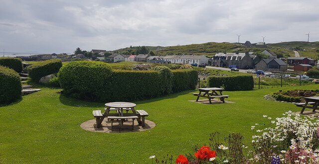
Coll - Arinagour - View from rear of Coll Hotel Looking across Loch Eatharna from the helipad at the back of the Coll Hotel to the many islets in the bay and, on the far left, part of the main island of Coll. The main islet seen at centre is Eilean Eatharna.
The hotel is situated in the village of Arinagour, the chief settlement on the Isle of Coll.
Coll - Arinagour - View from rear of Coll Hotel
Looking across Loch Eatharna from the helipad at the back of the Coll Hotel to the many islets in the bay and, on the far left, part of the main island of Coll. The main islet seen at centre is Eilean Eatharna. The hotel is situated in the village of Arinagour, the chief settlement on the Isle of Coll.
Coll - Arinagour - Houses on Main Street from Coll Hotel Looking southwards from the side of Coll Hotel looking along Shore Street and Main Street of Arinagour, the chief settlement on the Isle of Coll.
Coll - Arinagour - Houses on Main Street from Coll Hotel
Looking southwards from the side of Coll Hotel looking along Shore Street and Main Street of Arinagour, the chief settlement on the Isle of Coll.
Coll - Arinagour - 90mm gun This old 90mm gun was recovered by divers from a wreck off the coast and placed here between the ferry port and the village of Arinagour on the Isle of Coll.
Coll - Arinagour - 90mm gun
This old 90mm gun was recovered by divers from a wreck off the coast and placed here between the ferry port and the village of Arinagour on the Isle of Coll.
Coll - Arinagour - View out to sea from the Coll Hotel Taken from the garden of <a href="https://www.geograph.org.uk/photo/7238950">NM2257 : Coll - Arinagour - The Coll Hotel</a> looking out to sea. The little islet in the centre of the image is Eilean Eatharna, with the sea loch here being Loch Eatharna.
Coll - Arinagour - View out to sea from the Coll Hotel
Taken from the garden of NM2257 : Coll - Arinagour - The Coll Hotel looking out to sea. The little islet in the centre of the image is Eilean Eatharna, with the sea loch here being Loch Eatharna.
Coll - Arinagour - The Coll Hotel A view of the Coll Hotel from its grounds in the evening. The white building on the right contains the accommodation while the stone and glass building on the left is the bar and restaurant. 
To quote from their own website:
"The Coll Hotel was recently awarded ‘Independent Hotel of the Year’ at the 2020 CIS Excellence Awards. The Coll Hotel retained the ‘Scottish Casual Dining Restaurant of the Year’ at the 2021 SLTN Awards. It was also awarded ‘Scottish Island Hotel of the Year’ two years running by Hotel Review Scotland and received the prestigious ‘Flavour of Scotland Thistle Award’".
Their own website here: <span class="nowrap"><a title="https://collhotel.com" rel="nofollow ugc noopener" href="https://collhotel.com">Link</a><img style="margin-left:2px;" alt="External link" title="External link - shift click to open in new window" src="https://s1.geograph.org.uk/img/external.png" width="10" height="10"/></span>
Coll - Arinagour - The Coll Hotel
A view of the Coll Hotel from its grounds in the evening. The white building on the right contains the accommodation while the stone and glass building on the left is the bar and restaurant. To quote from their own website: "The Coll Hotel was recently awarded ‘Independent Hotel of the Year’ at the 2020 CIS Excellence Awards. The Coll Hotel retained the ‘Scottish Casual Dining Restaurant of the Year’ at the 2021 SLTN Awards. It was also awarded ‘Scottish Island Hotel of the Year’ two years running by Hotel Review Scotland and received the prestigious ‘Flavour of Scotland Thistle Award’". Their own website here: LinkExternal link
Coll - Arinagour - Coll Hotel three-quarter view Looking from the grounds of <a href="https://www.geograph.org.uk/photo/7238950">NM2257 : Coll - Arinagour - The Coll Hotel</a> at the older part of the hotel which contains the accommodation.
Coll - Arinagour - Coll Hotel three-quarter view
Looking from the grounds of NM2257 : Coll - Arinagour - The Coll Hotel at the older part of the hotel which contains the accommodation.
Coll - Arinagour - Coll Hotel - Rear entrance This is the rear of <a href="https://www.geograph.org.uk/photo/7238950">NM2257 : Coll - Arinagour - The Coll Hotel</a> but is the main entrance to it from the village and from its car park.
Coll - Arinagour - Coll Hotel - Rear entrance
This is the rear of NM2257 : Coll - Arinagour - The Coll Hotel but is the main entrance to it from the village and from its car park.
Coll - Arinagour - Coll Hotel gardens A view across the gardens on the southeastern side of <a href="https://www.geograph.org.uk/photo/7238950">NM2257 : Coll - Arinagour - The Coll Hotel</a> with the village of Arinagour in the background.
Coll - Arinagour - Coll Hotel gardens
A view across the gardens on the southeastern side of NM2257 : Coll - Arinagour - The Coll Hotel with the village of Arinagour in the background.
Coll - Arinagour - View across The Smiddy to the village As 'The Smiddy' means a smithy, i.e. a blacksmith's workplace, I'm not sure that this little inlet is actually called that, but that is what the map suggests.
The houses along Shore Street and Main Street can be seen on the left, heading southwards out from the centre of the village of Arinagour.
Taken from <a href="https://www.geograph.org.uk/photo/7238968">NM2257 : Coll - Arinagour - Coll Hotel gardens</a>
Coll - Arinagour - View across The Smiddy to the village
As 'The Smiddy' means a smithy, i.e. a blacksmith's workplace, I'm not sure that this little inlet is actually called that, but that is what the map suggests. The houses along Shore Street and Main Street can be seen on the left, heading southwards out from the centre of the village of Arinagour. Taken from NM2257 : Coll - Arinagour - Coll Hotel gardens
Coll - Eilean Eatharna The small domed island seen out to sea here is Eilean Eatharna, a small island in Loch Eatharna a sea loch to the south of Arinagour, the chief settlement on the Isle of Coll. This view taken from <a href="https://www.geograph.org.uk/photo/7238968">NM2257 : Coll - Arinagour - Coll Hotel gardens</a>
It is about 9.4acres (3.8ha) in area at the high water mark, considerably larger at low tide. It rises to a little over 10m (33') and has never been populated.
In front of it is the small pillar on Sgeir Dhubh (Black Skerry) - see <a href="https://www.geograph.org.uk/photo/7239604">NM2256 : Coll - Sgeir Dhubh and Cairn na Burgh Beg & More</a>
Coll - Eilean Eatharna
The small domed island seen out to sea here is Eilean Eatharna, a small island in Loch Eatharna a sea loch to the south of Arinagour, the chief settlement on the Isle of Coll. This view taken from NM2257 : Coll - Arinagour - Coll Hotel gardens It is about 9.4acres (3.8ha) in area at the high water mark, considerably larger at low tide. It rises to a little over 10m (33') and has never been populated. In front of it is the small pillar on Sgeir Dhubh (Black Skerry) - see NM2256 : Coll - Sgeir Dhubh and Cairn na Burgh Beg & More
Coll - Sgeir Dhubh and Cairn na Burgh Beg & More The dark little pillar is on the islet of Sgeir Dhubh (Black Skerry) in Loch Eatharna to the south of Arinagour on Coll. The sloping land immediately behind it is the tip of <a href="https://www.geograph.org.uk/photo/7239597">NM2356 : Coll - Eilean Eatharna</a> while in the background can be seen the two northernmost of the Treshnish Isles, Cairn na Burgh Beg (on left) and its larger companion Cairn na Burgh More. These islands are unusual in 'sharing' a castle, some of the ruins of which can just be discerned in this image on the larger island. The photo was taken from <a href="https://www.geograph.org.uk/photo/7238968">NM2257 : Coll - Arinagour - Coll Hotel gardens</a>.
Coll - Sgeir Dhubh and Cairn na Burgh Beg & More
The dark little pillar is on the islet of Sgeir Dhubh (Black Skerry) in Loch Eatharna to the south of Arinagour on Coll. The sloping land immediately behind it is the tip of NM2356 : Coll - Eilean Eatharna while in the background can be seen the two northernmost of the Treshnish Isles, Cairn na Burgh Beg (on left) and its larger companion Cairn na Burgh More. These islands are unusual in 'sharing' a castle, some of the ruins of which can just be discerned in this image on the larger island. The photo was taken from NM2257 : Coll - Arinagour - Coll Hotel gardens.
Coll - Arinagour - Shore Street Looking down Shore Street from near to <a href="https://www.geograph.org.uk/photo/7242902">NM2257 : Coll - Arinagour - The Island Café</a>. A little further on this street changes its name to Main Street as it heads out of the village southwards.
See the attached Arinagour description for links to 1930s photos of these houses.
Coll - Arinagour - Shore Street
Looking down Shore Street from near to NM2257 : Coll - Arinagour - The Island Café. A little further on this street changes its name to Main Street as it heads out of the village southwards. See the attached Arinagour description for links to 1930s photos of these houses.
Coll - Arinagour - Cottages on Main Street These are the last five cottages on Main Street in Arinagour as you go through the village heading southwards. They are numbered 1 to 5 (with No.1 being the furthest away in this photo). Main Street is a seamless  continuation of Shore Street.
This is the opposite view to <a href="https://www.geograph.org.uk/photo/7242919">NM2257 : Coll - Arinagour - Numbers 1 to 5, Main Street</a>
See the attached Arinagour description for links to 1930s photos of these houses.
Coll - Arinagour - Cottages on Main Street
These are the last five cottages on Main Street in Arinagour as you go through the village heading southwards. They are numbered 1 to 5 (with No.1 being the furthest away in this photo). Main Street is a seamless continuation of Shore Street. This is the opposite view to NM2257 : Coll - Arinagour - Numbers 1 to 5, Main Street See the attached Arinagour description for links to 1930s photos of these houses.
Coll - Arinagour - The Island Café This splendid little café is opposite Arinagour's harbour on Shore Street. The road just beyond it on the left leads up to the Post Office.
The café is the only place to eat on Coll apart from the Coll Hotel - but note that they are only open Wed - Fri for dinner, or Wed - Sat for breakfast & lunch [Info as at 2022]. See their website here: <span class="nowrap"><a title="https://islandcafecoll.co.uk" rel="nofollow ugc noopener" href="https://islandcafecoll.co.uk">Link</a><img style="margin-left:2px;" alt="External link" title="External link - shift click to open in new window" src="https://s1.geograph.org.uk/img/external.png" width="10" height="10"/></span>
Coll - Arinagour - The Island Café
This splendid little café is opposite Arinagour's harbour on Shore Street. The road just beyond it on the left leads up to the Post Office. The café is the only place to eat on Coll apart from the Coll Hotel - but note that they are only open Wed - Fri for dinner, or Wed - Sat for breakfast & lunch [Info as at 2022]. See their website here: LinkExternal link
Coll - Arinagour - Numbers 1 to 5, Main Street These are the first five houses on Main Street as one enters from the south (e.g. from the ferry). A little further on the street changes its name to Shore Street.
They were built early in the C19th (c.1812 I believe) to house workers on the Laird's estate. They originally had flat roofs but these were replaced with the current pitched ones in the 1930s.
This is the opposite view to <a href="https://www.geograph.org.uk/photo/7242892">NM2257 : Coll - Arinagour - Cottages on Main Street</a>
See the attached Arinagour description for links to 1930s photos of these houses.
Coll - Arinagour - Numbers 1 to 5, Main Street
These are the first five houses on Main Street as one enters from the south (e.g. from the ferry). A little further on the street changes its name to Shore Street. They were built early in the C19th (c.1812 I believe) to house workers on the Laird's estate. They originally had flat roofs but these were replaced with the current pitched ones in the 1930s. This is the opposite view to NM2257 : Coll - Arinagour - Cottages on Main Street See the attached Arinagour description for links to 1930s photos of these houses.
Coll - Arinagour - Northern end of Shore Street This is the opposite view to <a href="https://www.geograph.org.uk/photo/7242882">NM2257 : Coll - Arinagour - Shore Street</a> looking in a northerly-ish direction. The little building in the distance with the red door is the island's fire station at NM22395724
See the attached Arinagour description for links to 1930s photos of these houses.
Coll - Arinagour - Northern end of Shore Street
This is the opposite view to NM2257 : Coll - Arinagour - Shore Street looking in a northerly-ish direction. The little building in the distance with the red door is the island's fire station at NM22395724 See the attached Arinagour description for links to 1930s photos of these houses.
Coll - Arinagour - Entering the village from the south As you approach Arinagour from the ferry this is the first glimpse of the old village though a set back row of cottages and a few more modern building are off to the left (west) beforehand.
The cottages ahead on the left can be seen in a closer view here: <a href="https://www.geograph.org.uk/photo/7242919">NM2257 : Coll - Arinagour - Numbers 1 to 5, Main Street</a>
See also shared descriptions below:
Coll - Arinagour - Entering the village from the south
As you approach Arinagour from the ferry this is the first glimpse of the old village though a set back row of cottages and a few more modern building are off to the left (west) beforehand. The cottages ahead on the left can be seen in a closer view here: NM2257 : Coll - Arinagour - Numbers 1 to 5, Main Street See also shared descriptions below:
Coll - Arinagour - Coastguard station and vehicle Coll's little coastguard station with its Search & Rescue Land Rover parked in front is towards the south of the village of Arinagour on the way to the ferry terminal.
Coll - Arinagour - Coastguard station and vehicle
Coll's little coastguard station with its Search & Rescue Land Rover parked in front is towards the south of the village of Arinagour on the way to the ferry terminal.
Show me another place!

An Garbh-ard is located at Grid Ref: NM2255 (Lat: 56.612164, Lng: -6.525949)

Unitary Authority: Argyll and Bute

Police Authority: Argyll and West Dunbartonshire

What 3 Words

///heartless.fault.dynamics. Near Arinagour, Argyll & Bute

Related Wikis

Eilean Ornsay

Eilean Ornsay is a rocky and uninhabited island located off the south-western coast of the Inner Hebridean island of Coll. It is situated on the western...

Arinagour

Arinagour (Scottish Gaelic: Àirigh nan Gobhar, "shieling of the goats") is a village on the island of Coll, in the Argyll and Bute council area of Scotland...

Coll

Coll (; Scottish Gaelic: Cola; Scots: Coll) is an island located west of the Isle of Mull in the Inner Hebrides of Scotland. Coll is known for its sandy...

Dùn Anlaimh

Dùn Anlaimh, also known as Dùn Amhlaidh, and Eilean nan Cinneachan, is a crannog (an artificial island), located within Loch nan Cinneachan on the Inner...

Acha, Coll

Acha (Gaelic: An t-Achadh, tranlsating to "The Field") is a small hamlet on the Scottish island of Coll. == References == == See also == Dùn an Achaidh...

Dùn an Achaidh

Dùn an Achaidh, sometimes Anglicised as Dun Acha, is a dun located near the village of Acha on the Inner Hebridean island of Coll. It is considered the...

Totamore dun

Totamore Dun is a dun located at grid reference NM17625713; near the settlement of Totamore, on the Inner Hebridean island of Coll. It occupies the summit...

Dùn Dubh

Dùn Dubh is a hillfort, located on the Inner Hebridean island of Coll. The fort is one of three associated with a local tradition which states that they...

Nearby Amenities

Located within 500m of 56.612164,-6.525949
Natural: rock
Source: OS7
Tidal: yes
Lat/Long: 56.6105027/-6.5274499
Natural: rock
Source: OS7
Tidal: yes
Lat/Long: 56.6095858/-6.5263784
Natural: rock
Source: OS7
Tidal: yes
Lat/Long: 56.610034/-6.5255656
Natural: rock
Source: OS7
Tidal: yes
Lat/Long: 56.6103193/-6.5247158
Natural: rock
Source: OS7
Tidal: yes
Lat/Long: 56.6107268/-6.5244201
Natural: rock
Source: OS7
Tidal: yes
Lat/Long: 56.6109101/-6.5250483
Natural: rock
Source: OS7
Tidal: yes
Lat/Long: 56.6108083/-6.5219446
Seamark Light Category: vertical
Seamark Light Character: F
Seamark Light Colour: red
Seamark Light Height: 12
Seamark Light Multiple: 2
Seamark Light Reference: A 4087
Seamark Type: light_minor
Source: US NGA Pub. 114. 2011-05-26.
Lat/Long: 56.6141621/-6.5214395
Caolas an Eilein
Lang: gd
Natural: strait
Lat/Long: 56.6092123/-6.5281554
Power: pole
Lat/Long: 56.6153586/-6.5243061
Power: pole
Lat/Long: 56.6155759/-6.5247981
Power: pole
Lat/Long: 56.6158106/-6.5253788
Power: pole
Lat/Long: 56.6160906/-6.5260672
Power: pole
Lat/Long: 56.6151285/-6.5254358
Power: pole
Lat/Long: 56.611847/-6.5309283
Power: pole
Lat/Long: 56.6123804/-6.529978
Power: pole
Lat/Long: 56.6130044/-6.5289222
Power: pole
Lat/Long: 56.6136877/-6.527784
Power: pole
Lat/Long: 56.6141223/-6.527028
Power: pole
Lat/Long: 56.6146556/-6.5261749
Power: pole
Lat/Long: 56.6160372/-6.524513
Power: pole
Lat/Long: 56.6165008/-6.5245405
Barrier: cattle_grid
Lat/Long: 56.6160911/-6.5243368
Caolas an Eilein
Place: isolated_dwelling
Lat/Long: 56.6117101/-6.5305903
The data included in this document is from www.openstreetmap.org. The data is made available under ODbL.

Have you been to An Garbh-ard?

Leave your review of An Garbh-ard below (or comments, questions and feedback).