Geodha na Tobrach

Coastal Feature, Headland, Point in Ross-shire

Scotland

Geodha na Tobrach

View towards Loch Chàrlabhaigh
View towards Loch Chàrlabhaigh Credit: David Dixon

Geodha na Tobrach, located in Ross-shire, Scotland, is a stunning coastal feature that stands out as a prominent headland and point along the rugged northern coastline. The name Geodha na Tobrach translates to "Bay of the Well" in Scottish Gaelic, which reflects the geological and cultural significance of this area.

As a headland, Geodha na Tobrach juts out into the North Sea, providing a dramatic and picturesque landscape. The headland is characterized by steep cliffs that rise above the crashing waves below, creating a mesmerizing display of natural beauty. The cliffs are composed of weather-resistant rocks, predominantly sandstone and granite, which have been shaped over millions of years by the relentless forces of wind and water.

Geodha na Tobrach also features a point that stretches out from the headland, offering panoramic views of the surrounding coastal scenery. The point is an ideal vantage point for observing the diverse marine life that inhabits the area, including seals, whales, and a variety of seabirds.

The coastal path that winds its way along Geodha na Tobrach provides an opportunity for visitors to explore the area's rich biodiversity and appreciate its geological significance. The path offers easy access to the headland and the point, allowing visitors to experience the raw power of the North Sea while enjoying the tranquility of the surrounding natural environment.

Overall, Geodha na Tobrach stands as a captivating coastal feature, combining stunning cliffs, breathtaking views, and a rich natural heritage. Whether for nature enthusiasts, photographers, or those seeking a moment of solitude, this headland and point are sure to leave a lasting impression.

If you have any feedback on the listing, please let us know in the comments section below.

Geodha na Tobrach Images

Images are sourced within 2km of 58.278816/-6.8073781 or Grid Reference NB1842. Thanks to Geograph Open Source API. All images are credited.

View towards Loch Chàrlabhaigh
Dun Carloway Broch A Broch is an Iron Age, drystone structure found almost exclusively in Scotland and the Isles. Designed to impress and defend, they were probably the homes of tribal leaders and important members of the community. They are built with two concentric walls of stone, with a stairway or gallery within the walls to the upper floors. 

Dun Carloway (Dùn Chàrlabhaigh) broch is located above Loch an Dùin on a rocky knoll in a good defensive position. It is one of the best preserved in the Hebrides and some sections of the outer wall stand approximately 9 metres tall so they have survived almost intact. It dates back more than 2000 years; it is thought to have been constructed about 200 BC. Broch-building ceased around AD 100, but they may have continued in use. Evidence from excavations suggests Dun Carloway may have been used until about AD 1000. In the 17th century the broch is said to have been used as a stronghold by members of the Morison Clan when it was besieged by the Macaulays of Uig, with whom they were feuding. The implication is that the wall of the broch were relatively complete until this date.

The broch is a scheduled monument (SM90110 <span class="nowrap"><a title="https://portal.historicenvironment.scot/designation/SM90110" rel="nofollow ugc noopener" href="https://portal.historicenvironment.scot/designation/SM90110">Link</a><img style="margin-left:2px;" alt="External link" title="External link - shift click to open in new window" src="https://s1.geograph.org.uk/img/external.png" width="10" height="10"/></span> Historic Environment Scotland). More information can be found in the statement of significance <span class="nowrap"><a title="https://app-hes-pubs-prod-neu-01.azurewebsites.net/api/file/185e6bb3-1b4d-4c6d-8497-acaf009e3ef6" rel="nofollow ugc noopener" href="https://app-hes-pubs-prod-neu-01.azurewebsites.net/api/file/185e6bb3-1b4d-4c6d-8497-acaf009e3ef6">Link</a><img style="margin-left:2px;" alt="External link" title="External link - shift click to open in new window" src="https://s1.geograph.org.uk/img/external.png" width="10" height="10"/></span>  (pdf file on the HES website).
Dun Carloway Broch
A Broch is an Iron Age, drystone structure found almost exclusively in Scotland and the Isles. Designed to impress and defend, they were probably the homes of tribal leaders and important members of the community. They are built with two concentric walls of stone, with a stairway or gallery within the walls to the upper floors. Dun Carloway (Dùn Chàrlabhaigh) broch is located above Loch an Dùin on a rocky knoll in a good defensive position. It is one of the best preserved in the Hebrides and some sections of the outer wall stand approximately 9 metres tall so they have survived almost intact. It dates back more than 2000 years; it is thought to have been constructed about 200 BC. Broch-building ceased around AD 100, but they may have continued in use. Evidence from excavations suggests Dun Carloway may have been used until about AD 1000. In the 17th century the broch is said to have been used as a stronghold by members of the Morison Clan when it was besieged by the Macaulays of Uig, with whom they were feuding. The implication is that the wall of the broch were relatively complete until this date. The broch is a scheduled monument (SM90110 LinkExternal link Historic Environment Scotland). More information can be found in the statement of significance LinkExternal link (pdf file on the HES website).
Dun Carloway (Dùn Chàrlabhaigh) A Broch is an Iron Age, drystone structure found almost exclusively in Scotland and the Isles. Designed to impress and defend, they were probably the homes of tribal leaders and important members of the community. They are built with two concentric walls of stone, with a stairway or gallery within the walls to the upper floors. 

Dun Carloway (Dùn Chàrlabhaigh) broch is located above Loch an Dùin on a rocky knoll in a good defensive position. It is one of the best preserved in the Hebrides and some sections of the outer wall stand approximately 9 metres tall so they have survived almost intact. It dates back more than 2000 years; it is thought to have been constructed about 200 BC. Broch-building ceased around AD 100, but they may have continued in use. Evidence from excavations suggests Dun Carloway may have been used until about AD 1000. In the 17th century the broch is said to have been used as a stronghold by members of the Morison Clan when it was besieged by the Macaulays of Uig, with whom they were feuding. The implication is that the wall of the broch were relatively complete until this date.

The broch is a scheduled monument (SM90110 <span class="nowrap"><a title="https://portal.historicenvironment.scot/designation/SM90110" rel="nofollow ugc noopener" href="https://portal.historicenvironment.scot/designation/SM90110">Link</a><img style="margin-left:2px;" alt="External link" title="External link - shift click to open in new window" src="https://s1.geograph.org.uk/img/external.png" width="10" height="10"/></span> Historic Environment Scotland). More information can be found in the statement of significance <span class="nowrap"><a title="https://app-hes-pubs-prod-neu-01.azurewebsites.net/api/file/185e6bb3-1b4d-4c6d-8497-acaf009e3ef6" rel="nofollow ugc noopener" href="https://app-hes-pubs-prod-neu-01.azurewebsites.net/api/file/185e6bb3-1b4d-4c6d-8497-acaf009e3ef6">Link</a><img style="margin-left:2px;" alt="External link" title="External link - shift click to open in new window" src="https://s1.geograph.org.uk/img/external.png" width="10" height="10"/></span>  (pdf file on the HES website).
Dun Carloway (Dùn Chàrlabhaigh)
A Broch is an Iron Age, drystone structure found almost exclusively in Scotland and the Isles. Designed to impress and defend, they were probably the homes of tribal leaders and important members of the community. They are built with two concentric walls of stone, with a stairway or gallery within the walls to the upper floors. Dun Carloway (Dùn Chàrlabhaigh) broch is located above Loch an Dùin on a rocky knoll in a good defensive position. It is one of the best preserved in the Hebrides and some sections of the outer wall stand approximately 9 metres tall so they have survived almost intact. It dates back more than 2000 years; it is thought to have been constructed about 200 BC. Broch-building ceased around AD 100, but they may have continued in use. Evidence from excavations suggests Dun Carloway may have been used until about AD 1000. In the 17th century the broch is said to have been used as a stronghold by members of the Morison Clan when it was besieged by the Macaulays of Uig, with whom they were feuding. The implication is that the wall of the broch were relatively complete until this date. The broch is a scheduled monument (SM90110 LinkExternal link Historic Environment Scotland). More information can be found in the statement of significance LinkExternal link (pdf file on the HES website).
Dùn Chàrlabhaigh Broch A Broch is an Iron Age, drystone structure found almost exclusively in Scotland and the Isles. Designed to impress and defend, they were probably the homes of tribal leaders and important members of the community. They are built with two concentric walls of stone, with a stairway or gallery within the walls to the upper floors. 

Dun Carloway (Dùn Chàrlabhaigh) broch is located above Loch an Dùin on a rocky knoll in a good defensive position. It is one of the best preserved in the Hebrides and some sections of the outer wall stand approximately 9 metres tall so they have survived almost intact. It dates back more than 2000 years; it is thought to have been constructed about 200 BC. Broch-building ceased around AD 100, but they may have continued in use. Evidence from excavations suggests Dun Carloway may have been used until about AD 1000. In the 17th century the broch is said to have been used as a stronghold by members of the Morison Clan when it was besieged by the Macaulays of Uig, with whom they were feuding. The implication is that the wall of the broch were relatively complete until this date.

The broch is a scheduled monument (SM90110 <span class="nowrap"><a title="https://portal.historicenvironment.scot/designation/SM90110" rel="nofollow ugc noopener" href="https://portal.historicenvironment.scot/designation/SM90110">Link</a><img style="margin-left:2px;" alt="External link" title="External link - shift click to open in new window" src="https://s1.geograph.org.uk/img/external.png" width="10" height="10"/></span> Historic Environment Scotland). More information can be found in the statement of significance <span class="nowrap"><a title="https://app-hes-pubs-prod-neu-01.azurewebsites.net/api/file/185e6bb3-1b4d-4c6d-8497-acaf009e3ef6" rel="nofollow ugc noopener" href="https://app-hes-pubs-prod-neu-01.azurewebsites.net/api/file/185e6bb3-1b4d-4c6d-8497-acaf009e3ef6">Link</a><img style="margin-left:2px;" alt="External link" title="External link - shift click to open in new window" src="https://s1.geograph.org.uk/img/external.png" width="10" height="10"/></span>  (pdf file on the HES website).
Dùn Chàrlabhaigh Broch
A Broch is an Iron Age, drystone structure found almost exclusively in Scotland and the Isles. Designed to impress and defend, they were probably the homes of tribal leaders and important members of the community. They are built with two concentric walls of stone, with a stairway or gallery within the walls to the upper floors. Dun Carloway (Dùn Chàrlabhaigh) broch is located above Loch an Dùin on a rocky knoll in a good defensive position. It is one of the best preserved in the Hebrides and some sections of the outer wall stand approximately 9 metres tall so they have survived almost intact. It dates back more than 2000 years; it is thought to have been constructed about 200 BC. Broch-building ceased around AD 100, but they may have continued in use. Evidence from excavations suggests Dun Carloway may have been used until about AD 1000. In the 17th century the broch is said to have been used as a stronghold by members of the Morison Clan when it was besieged by the Macaulays of Uig, with whom they were feuding. The implication is that the wall of the broch were relatively complete until this date. The broch is a scheduled monument (SM90110 LinkExternal link Historic Environment Scotland). More information can be found in the statement of significance LinkExternal link (pdf file on the HES website).
Broch at Doune Carloway A Broch is an Iron Age, drystone structure found almost exclusively in Scotland and the Isles. Designed to impress and defend, they were probably the homes of tribal leaders and important members of the community. They are built with two concentric walls of stone, with a stairway or gallery within the walls to the upper floors. 

Dun Carloway (Dùn Chàrlabhaigh) broch is located above Loch an Dùin on a rocky knoll in a good defensive position. It is one of the best preserved in the Hebrides and some sections of the outer wall stand approximately 9 metres tall so they have survived almost intact. It dates back more than 2000 years; it is thought to have been constructed about 200 BC. Broch-building ceased around AD 100, but they may have continued in use. Evidence from excavations suggests Dun Carloway may have been used until about AD 1000. In the 17th century the broch is said to have been used as a stronghold by members of the Morison Clan when it was besieged by the Macaulays of Uig, with whom they were feuding. The implication is that the wall of the broch were relatively complete until this date.

The broch is a scheduled monument (SM90110 <span class="nowrap"><a title="https://portal.historicenvironment.scot/designation/SM90110" rel="nofollow ugc noopener" href="https://portal.historicenvironment.scot/designation/SM90110">Link</a><img style="margin-left:2px;" alt="External link" title="External link - shift click to open in new window" src="https://s1.geograph.org.uk/img/external.png" width="10" height="10"/></span> Historic Environment Scotland). More information can be found in the statement of significance <span class="nowrap"><a title="https://app-hes-pubs-prod-neu-01.azurewebsites.net/api/file/185e6bb3-1b4d-4c6d-8497-acaf009e3ef6" rel="nofollow ugc noopener" href="https://app-hes-pubs-prod-neu-01.azurewebsites.net/api/file/185e6bb3-1b4d-4c6d-8497-acaf009e3ef6">Link</a><img style="margin-left:2px;" alt="External link" title="External link - shift click to open in new window" src="https://s1.geograph.org.uk/img/external.png" width="10" height="10"/></span>  (pdf file on the HES website).
Broch at Doune Carloway
A Broch is an Iron Age, drystone structure found almost exclusively in Scotland and the Isles. Designed to impress and defend, they were probably the homes of tribal leaders and important members of the community. They are built with two concentric walls of stone, with a stairway or gallery within the walls to the upper floors. Dun Carloway (Dùn Chàrlabhaigh) broch is located above Loch an Dùin on a rocky knoll in a good defensive position. It is one of the best preserved in the Hebrides and some sections of the outer wall stand approximately 9 metres tall so they have survived almost intact. It dates back more than 2000 years; it is thought to have been constructed about 200 BC. Broch-building ceased around AD 100, but they may have continued in use. Evidence from excavations suggests Dun Carloway may have been used until about AD 1000. In the 17th century the broch is said to have been used as a stronghold by members of the Morison Clan when it was besieged by the Macaulays of Uig, with whom they were feuding. The implication is that the wall of the broch were relatively complete until this date. The broch is a scheduled monument (SM90110 LinkExternal link Historic Environment Scotland). More information can be found in the statement of significance LinkExternal link (pdf file on the HES website).
Dun Carloway A Broch is an Iron Age, drystone structure found almost exclusively in Scotland and the Isles. Designed to impress and defend, they were probably the homes of tribal leaders and important members of the community. They are built with two concentric walls of stone, with a stairway or gallery within the walls to the upper floors. 

Dun Carloway (Dùn Chàrlabhaigh) broch is located above Loch an Dùin on a rocky knoll in a good defensive position. It is one of the best preserved in the Hebrides and some sections of the outer wall stand approximately 9 metres tall so they have survived almost intact. It dates back more than 2000 years; it is thought to have been constructed about 200 BC. Broch-building ceased around AD 100, but they may have continued in use. Evidence from excavations suggests Dun Carloway may have been used until about AD 1000. In the 17th century the broch is said to have been used as a stronghold by members of the Morison Clan when it was besieged by the Macaulays of Uig, with whom they were feuding. The implication is that the wall of the broch were relatively complete until this date.

The broch is a scheduled monument (SM90110 <span class="nowrap"><a title="https://portal.historicenvironment.scot/designation/SM90110" rel="nofollow ugc noopener" href="https://portal.historicenvironment.scot/designation/SM90110">Link</a><img style="margin-left:2px;" alt="External link" title="External link - shift click to open in new window" src="https://s1.geograph.org.uk/img/external.png" width="10" height="10"/></span> Historic Environment Scotland). More information can be found in the statement of significance <span class="nowrap"><a title="https://app-hes-pubs-prod-neu-01.azurewebsites.net/api/file/185e6bb3-1b4d-4c6d-8497-acaf009e3ef6" rel="nofollow ugc noopener" href="https://app-hes-pubs-prod-neu-01.azurewebsites.net/api/file/185e6bb3-1b4d-4c6d-8497-acaf009e3ef6">Link</a><img style="margin-left:2px;" alt="External link" title="External link - shift click to open in new window" src="https://s1.geograph.org.uk/img/external.png" width="10" height="10"/></span>  (pdf file on the HES website).
Dun Carloway
A Broch is an Iron Age, drystone structure found almost exclusively in Scotland and the Isles. Designed to impress and defend, they were probably the homes of tribal leaders and important members of the community. They are built with two concentric walls of stone, with a stairway or gallery within the walls to the upper floors. Dun Carloway (Dùn Chàrlabhaigh) broch is located above Loch an Dùin on a rocky knoll in a good defensive position. It is one of the best preserved in the Hebrides and some sections of the outer wall stand approximately 9 metres tall so they have survived almost intact. It dates back more than 2000 years; it is thought to have been constructed about 200 BC. Broch-building ceased around AD 100, but they may have continued in use. Evidence from excavations suggests Dun Carloway may have been used until about AD 1000. In the 17th century the broch is said to have been used as a stronghold by members of the Morison Clan when it was besieged by the Macaulays of Uig, with whom they were feuding. The implication is that the wall of the broch were relatively complete until this date. The broch is a scheduled monument (SM90110 LinkExternal link Historic Environment Scotland). More information can be found in the statement of significance LinkExternal link (pdf file on the HES website).
Doune Carloway
Doune Carloway
Doune Carloway, view from the broch The village of Doune is named after its Iron Age broch (<a href="https://www.geograph.org.uk/photo/7630277">NB1941 : Dun Carloway Broch</a>). Doune Carloway was at one time a farm, along with Kirvick but in 1828 it was divided into crofts for tenants evicted from Hacklete, Bernera.
Doune Carloway, view from the broch
The village of Doune is named after its Iron Age broch (NB1941 : Dun Carloway Broch). Doune Carloway was at one time a farm, along with Kirvick but in 1828 it was divided into crofts for tenants evicted from Hacklete, Bernera.
Doune Carloway, Loch an Dùin and the coast View to the west from <a href="https://www.geograph.org.uk/photo/7630291">NB1941 : Broch at Doune Carloway</a> past  Loch an Dùin and the edge of the village, towards the coast.
Doune Carloway, Loch an Dùin and the coast
View to the west from NB1941 : Broch at Doune Carloway past Loch an Dùin and the edge of the village, towards the coast.
View from Dun Carloway Broch - Loch an Dùin Looking south from <a href="https://www.geograph.org.uk/photo/7630291">NB1941 : Broch at Doune Carloway</a>.
View from Dun Carloway Broch - Loch an Dùin
Looking south from NB1941 : Broch at Doune Carloway.
Carloway, Isle of Lewis
Byre, Carloway
Byre, Carloway
Hill near Carloway
Hill near Carloway
Dùn Chàrlabhaigh The broch at Carloway.
Dùn Chàrlabhaigh
The broch at Carloway.
Blackhouse base at Carloway Seen from the path that leads to the broch.
Blackhouse base at Carloway
Seen from the path that leads to the broch.
Welcome to Dùn Chàrlabhaigh Historic Scotland information panel about the broch.
Welcome to Dùn Chàrlabhaigh
Historic Scotland information panel about the broch.
Lazy beds below Cnoc Buaile Fang, Isle of Lewis
Broch at Doun Carloway
Show me another place!

Geodha na Tobrach is located at Grid Ref: NB1842 (Lat: 58.278816, Lng: -6.8073781)

Unitary Authority: Na h-Eileanan an Iar

Police Authority: Highlands and Islands

What 3 Words

///dreamer.obtain.mandolin. Near Carloway, Na h-Eileanan Siar

Related Wikis

Borrowston, Lewis

Borrowston (Scottish Gaelic: Borghastan), with a population of about 50, is a crofting township situated on the Isle of Lewis, on the Outer Hebrides of...

Dun Carloway

Dun Carloway (Scottish Gaelic: Dùn Chàrlabhaigh) is a broch situated in the district of Carloway, on the west coast of the Isle of Lewis, Scotland (grid...

Garenin

Garenin (Scottish Gaelic: Na Gearrannan) is a crofting township on the west coast of the Isle of Lewis in the Outer Hebrides of Scotland. Garenin is in...

Carloway

Carloway (Scottish Gaelic: Càrlabhagh [ˈkʰaːɾɫ̪ə.ɤː]) is a crofting township and a district on the west coast of the Isle of Lewis, in the Outer Hebrides...

Cealasaigh

Cealasaigh or Kealasay is an islet in outer Loch Ròg, Lewis, Scotland that lies north of Traigh Mhór on Little Bernera and south of Campaigh. To the west...

Campaigh

Campaigh or Campay is a steep and rocky islet in outer Loch Ròg, Lewis, Scotland that lies north of Cealasaigh and Little Bernera. A huge natural arch...

Little Bernera

Little Bernera (Scottish Gaelic: Beàrnaraigh Beag) is a small island situated off the west coast of the Isle of Lewis in the Outer Hebrides.Little Bernera...

Tolsta Chaolais

Tolsta Chaolais (also Tolastadh Chaolais, Tolstadh a' Chaolais) is a village on the Isle of Lewis, Scotland. It consists of about forty houses, clustered...

Related Videos

Alpkit Kangri Carloway Trip

Gusting up to 50mph in Carloway, the Kangri never moved an inch.

Gearrannan village of traditional houses

Gearrannan Black House village on the Isle of Lewis.

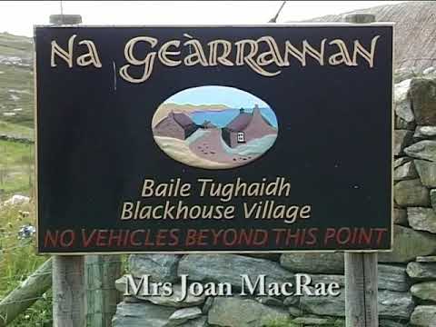
Pipe Major Bill Hepburn Jnr. at the Black Houses, Na Gearrannan, Isle of Lewis - 'Mrs Joan Macrae'.

Pipe Major Bill Hepburn Jnr. plays the pipe tune 'Mrs Joan Macrae' at the Black Houses of Na Gearrannan on the west coast of ...

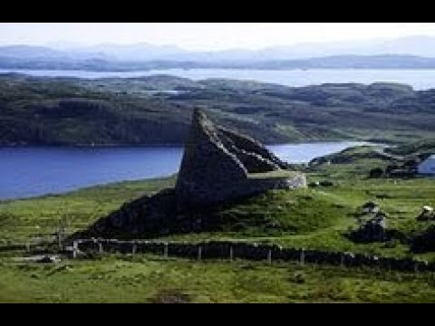
Dun Carloway Broch On Visit To Isle Of Lewis Outer Hebrides Scotland

Tour Scotland travel video, with Scottish music, of Dun Carloway Broch, Scottish Gaelic: Dùn Chàrlabhaigh, on visit to the west ...

Have you been to Geodha na Tobrach?

Leave your review of Geodha na Tobrach below (or comments, questions and feedback).