Geodh' an Fhàidhe

Coastal Feature, Headland, Point in Argyllshire

Scotland

Geodh' an Fhàidhe

Memorial to Lieutenant David Lowe Macintyre David Lowe Macintyre VC, CB (18 June 1895 – 31 July 1967) was a Scottish recipient of the Victoria Cross.
Memorial to Lieutenant David Lowe Macintyre Credit: Andrew Abbott

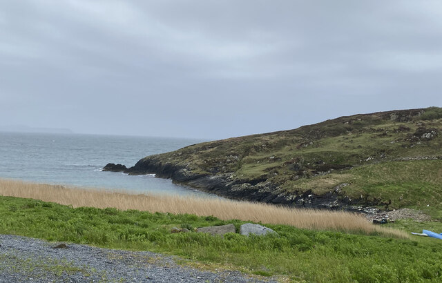
Geodh' an Fhàidhe, also known as Fairy Cove, is a picturesque coastal feature located in Argyllshire, Scotland. It is a breathtaking headland that juts out into the Atlantic Ocean, offering stunning views of the surrounding landscape.

Situated on the western coast of Scotland, Geodh' an Fhàidhe is characterized by its rugged cliffs, rocky outcrops, and pristine sandy beach. The headland is formed by layers of ancient rock, which have been shaped over centuries by the powerful forces of wind and waves.

The name Fairy Cove is said to have originated from the local folklore, which tells of fairies inhabiting the area and granting wishes to those who visit. This mythical charm adds to the allure of Geodh' an Fhàidhe, attracting visitors from far and wide.

The headland is a popular spot for nature lovers, hikers, and photographers due to its dramatic beauty. The cliffs provide nesting sites for various seabirds, including puffins and gannets. The beach is a haven for beachcombers and sunbathers, offering a peaceful retreat away from the hustle and bustle of everyday life.

Access to Geodh' an Fhàidhe is relatively easy, with a nearby car park and a well-maintained path leading to the headland. Visitors can explore the area on foot, taking in the panoramic views and immersing themselves in the tranquility of the surroundings.

In conclusion, Geodh' an Fhàidhe in Argyllshire is a captivating coastal feature that showcases the rugged beauty of Scotland's western coast. Its stunning cliffs, sandy beach, and mythical charm make it a must-visit destination for nature enthusiasts and those seeking a peaceful retreat.

If you have any feedback on the listing, please let us know in the comments section below.

Geodh' an Fhàidhe Images

Images are sourced within 2km of 55.672648/-6.4934602 or Grid Reference NR1751. Thanks to Geograph Open Source API. All images are credited.

Memorial to Lieutenant David Lowe Macintyre David Lowe Macintyre VC, CB (18 June 1895 – 31 July 1967) was a Scottish recipient of the Victoria Cross.
Memorial to Lieutenant David Lowe Macintyre
David Lowe Macintyre VC, CB (18 June 1895 – 31 July 1967) was a Scottish recipient of the Victoria Cross.
Boat under repair
Boat under repair
Main Street, Port Wemyss/Bun Othan
Village Hall
Village Hall
Portnahaven
Portnahaven
Views out to sea Portnahaven
Portnahaven, Parish Church
OS Cut Mark - Portnahaven, Parish Church <span class="nowrap"><a title="https://www.bench-marks.org.uk/bm58120" rel="nofollow ugc noopener" href="https://www.bench-marks.org.uk/bm58120">Link</a><img style="margin-left:2px;" alt="External link" title="External link - shift click to open in new window" src="https://s1.geograph.org.uk/img/external.png" width="10" height="10"/></span>
OS Cut Mark - Portnahaven, Parish Church
View to Orsay from Port Wemyss
Port Ellister
Port Ellister
Location of Cnoc Undail OS Pipe <span class="nowrap"><a title="http://trigpointing.uk/trig/9482" rel="nofollow ugc noopener" href="http://trigpointing.uk/trig/9482">Link</a><img style="margin-left:2px;" alt="External link" title="External link - shift click to open in new window" src="https://s1.geograph.org.uk/img/external.png" width="10" height="10"/></span>
Location of Cnoc Undail OS Pipe
Former Portnahaven Coast Guard Lookout
Portnahaven
Portnahaven
Former school, Portnahaven Now a holiday let.
Former school, Portnahaven
Now a holiday let.
OS Cut Mark - Portnahaven, Old School <span class="nowrap"><a title="https://www.bench-marks.org.uk/bm58122" rel="nofollow ugc noopener" href="https://www.bench-marks.org.uk/bm58122">Link</a><img style="margin-left:2px;" alt="External link" title="External link - shift click to open in new window" src="https://s1.geograph.org.uk/img/external.png" width="10" height="10"/></span>
OS Cut Mark - Portnahaven, Old School
Orsay Chapel and Lighthouse, Islay Orsay is a tiny island situated off the Rhinns peninsula on Islay's west coast. It is uninhabited now, but once was home to the lighthouse keeper and his family and, before that, presumably to a religious community.
Orsay Chapel and Lighthouse, Islay
Orsay is a tiny island situated off the Rhinns peninsula on Islay's west coast. It is uninhabited now, but once was home to the lighthouse keeper and his family and, before that, presumably to a religious community.
Portnahaven Bay
Portnahaven Bay
Show me another place!

Geodh' an Fhàidhe is located at Grid Ref: NR1751 (Lat: 55.672648, Lng: -6.4934602)

Unitary Authority: Argyll and Bute

Police Authority: Argyll and West Dunbartonshire

What 3 Words

///detriment.nobody.pram. Near Portnahaven, Argyll & Bute

Related Wikis

Nearby Amenities

Located within 500m of 55.672648,-6.4934602
Rhinns Point
Alt Name: Rinns Point
Natural: cape
Source: PGS
Wikidata: Q1416751
Wikipedia: de:Rhinns Point
Lat/Long: 55.67069/-6.48867
Rhinns Point
Alt Name: Rinns Point
Natural: cape
Source: PGS
Wikidata: Q1416751
Wikipedia: de:Rhinns Point
Lat/Long: 55.6710246/-6.4882919
The data included in this document is from www.openstreetmap.org. The data is made available under ODbL.

Have you been to Geodh' an Fhàidhe?

Leave your review of Geodh' an Fhàidhe below (or comments, questions and feedback).