Eilean Dubh

Coastal Feature, Headland, Point in Argyllshire

Scotland

Eilean Dubh

Plocaid Bo buoy, Gunna Sound
Plocaid Bo buoy, Gunna Sound Credit: Alpin Stewart

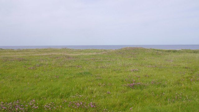
Eilean Dubh is a prominent coastal feature located in Argyllshire, Scotland. Situated on the west coast, it is specifically found on the southern end of the Isle of Mull, overlooking the Sound of Mull. This picturesque headland, also known as a point, boasts stunning natural beauty and offers breathtaking views of the surrounding area.

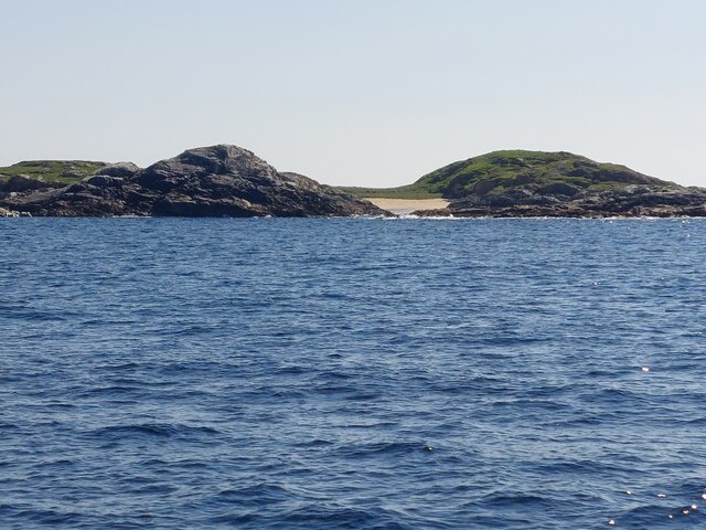
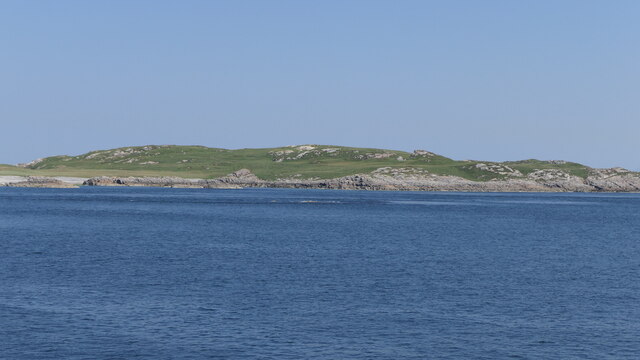
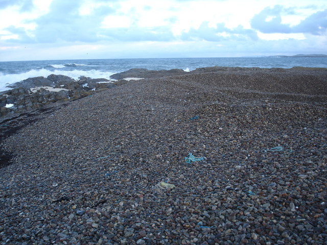
Eilean Dubh is characterized by its rugged and rocky terrain, which is typical of the region. The headland juts out into the sea, creating a dramatic and distinct landform. The cliffs that line the coast are composed of ancient volcanic rocks, adding to the area's geological significance.

The name "Eilean Dubh" translates to "Black Island" in Gaelic, and it refers to a small, uninhabited island that lies just off the headland. The island is known for its abundance of birdlife, including various species of seabirds and migratory birds. Birdwatchers often flock to Eilean Dubh to observe the diverse avian population.

The headland is a popular destination for both locals and tourists seeking outdoor recreational activities. Hiking trails traverse the area, offering visitors the opportunity to explore the stunning coastal scenery at their own pace. The rugged cliffs also attract rock climbers looking for a challenge.

In addition to its natural beauty, Eilean Dubh is steeped in rich history. It has been inhabited since ancient times, and evidence of early human settlements can still be found in the form of ancient ruins and standing stones scattered across the headland.

Overall, Eilean Dubh, Argyllshire, is a captivating coastal feature that combines natural beauty, outdoor activities, and historical significance, making it a must-visit destination for nature enthusiasts and history buffs alike.

If you have any feedback on the listing, please let us know in the comments section below.

Eilean Dubh Images

Images are sourced within 2km of 56.553536/-6.7510992 or Grid Reference NM0850. Thanks to Geograph Open Source API. All images are credited.

Plocaid Bo buoy, Gunna Sound
Port Chunn Nèill, Isle of Tiree
Northeastern corner of Tiree Coastal heath and rock at Urvaig. The basking shark tour boat is off shore with several snorkelling passengers and a couple of basking sharks.  Saw the boat from Coll the previous day but no sharks.
Northeastern corner of Tiree
Coastal heath and rock at Urvaig. The basking shark tour boat is off shore with several snorkelling passengers and a couple of basking sharks. Saw the boat from Coll the previous day but no sharks.
East coast of Tiree View past Gunna, along the coast of Coll towards the Sgùrr of Eigg.
East coast of Tiree
View past Gunna, along the coast of Coll towards the Sgùrr of Eigg.
Machair, Urvaig The northeast tip of Tiree.
Machair, Urvaig
The northeast tip of Tiree.
McNeil's Bay, Gunna
McNeil's Bay, Gunna
Gunna The 36m highpoint of the island at the west end.
Gunna
The 36m highpoint of the island at the west end.
West end of Gunna
West end of Gunna
Port Chunn Nèill An eider creche off Tiree.
Port Chunn Nèill
An eider creche off Tiree.
Port Chunn Nèill, Tiree
Coastal grassland at Urvaig
Port Chunn Nèill, northeast Tiree Gunna Sound leading into the Sea of the Hebrides.
Port Chunn Nèill, northeast Tiree
Gunna Sound leading into the Sea of the Hebrides.
Urvaig, Tiree Storm beach, looking north from Urvaig, Tiree
Urvaig, Tiree
Storm beach, looking north from Urvaig, Tiree
Watching for sharks off the Sound Of Gunna Looking north from Urvaig, Tiree, across Sound of Gunna towards Isle of Coll
Watching for sharks off the Sound Of Gunna
Looking north from Urvaig, Tiree, across Sound of Gunna towards Isle of Coll
Rocky coast of the most northerly part of Tiree The house in the distance on the 1:25000 is named Urvaig, but then so is the tip of the peninsula.
Rocky coast of the most northerly part of Tiree
The house in the distance on the 1:25000 is named Urvaig, but then so is the tip of the peninsula.
Across the Gunna Sound Unsurprising it is Gunna to be seen across the sound.  Coll can be made out behind Gunna.
Across the Gunna Sound
Unsurprising it is Gunna to be seen across the sound. Coll can be made out behind Gunna.
Foam on the rocks at Urvaig Roughs seas had generated foam which has collected here, much to the amusement of the dog.
Foam on the rocks at Urvaig
Roughs seas had generated foam which has collected here, much to the amusement of the dog.
Pebble beach at Urvaig The dip in the pebbles at the right hand side is where some have been removed and probably crushed and used as aggregate.
Pebble beach at Urvaig
The dip in the pebbles at the right hand side is where some have been removed and probably crushed and used as aggregate.
Show me another place!

Eilean Dubh is located at Grid Ref: NM0850 (Lat: 56.553536, Lng: -6.7510992)

Unitary Authority: Argyll and Bute

Police Authority: Argyll and West Dunbartonshire

What 3 Words

///trail.spaceship.donor. Near Scarinish, Argyll & Bute

Related Wikis

Gunna, Scotland

Gunna (Gaelic: Gunnaigh) is an island in the Inner Hebrides of Scotland. == Geography and geology == Gunna lies between Coll and Tiree, closer to Coll...

Dun Mor Vaul

Dun Mor Vaul (or simply Dun Mor; Scottish Gaelic: Dùn Mòr) is an iron-age broch located on the north coast of the island of Tiree, in Scotland. ��2�...

Tiree

Tiree (; Scottish Gaelic: Tiriodh, pronounced [ˈtʲʰiɾʲəɣ]) is the most westerly island in the Inner Hebrides of Scotland. The low-lying island, southwest...

Scarinish

Scarinish (Scottish Gaelic: Sgairinis [ˈs̪kaɾʲɪnɪʃ]) is the main village on the island of Tiree, in the Inner Hebrides of Scotland. It is located on the...

Nearby Amenities

Located within 500m of 56.553536,-6.7510992
Source: PGS
Lat/Long: 56.5549991/-6.7504874
Source: PGS
Lat/Long: 56.5551806/-6.7508979
Source: PGS
Lat/Long: 56.5551864/-6.7508116
Source: PGS
Lat/Long: 56.5550091/-6.7505397
Barrier: cattle_grid
Lat/Long: 56.5492771/-6.7528162
Power: pole
Lat/Long: 56.5502729/-6.7546392
Power: pole
Lat/Long: 56.5511925/-6.7541215
Power: pole
Lat/Long: 56.5521002/-6.7535931
Passing Place
Lat/Long: 56.5495973/-6.7529477
Urvaig
Place: locality
Lat/Long: 56.5561629/-6.7545551
The data included in this document is from www.openstreetmap.org. The data is made available under ODbL.

Have you been to Eilean Dubh?

Leave your review of Eilean Dubh below (or comments, questions and feedback).