Carnan Mòr

Coastal Feature, Headland, Point in Ross-shire

Scotland

Carnan Mòr

Rocks on Druim Raois Outcropping rock and boulders litter the moorland below Mealaisbhal.
Rocks on Druim Raois Credit: Alan Reid

Carnan Mòr is a prominent headland located in Ross-shire, Scotland. Situated along the country's picturesque coastline, it is known for its stunning natural beauty and rugged landscape. The headland is positioned at the point where the land juts out into the sea, forming a distinct point that stands out from the surrounding area.

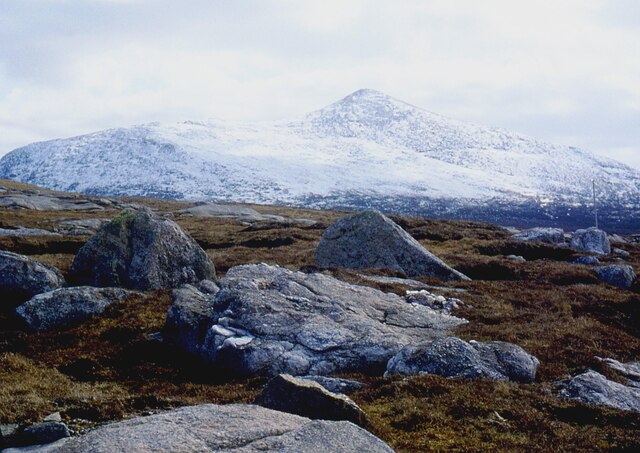
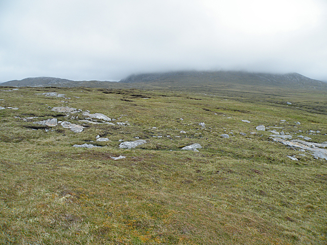
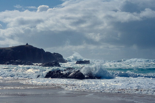
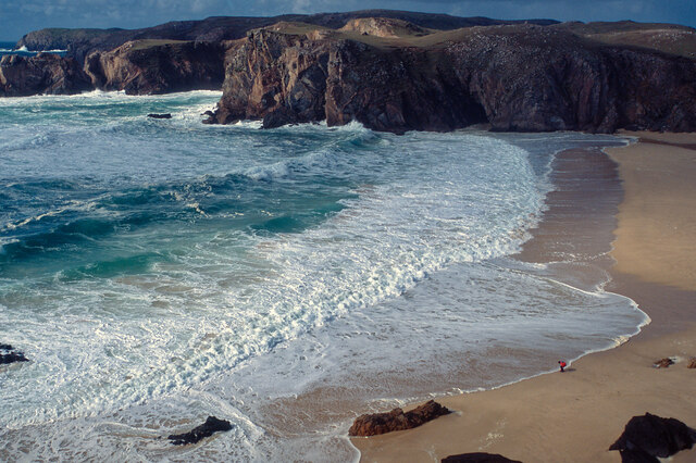
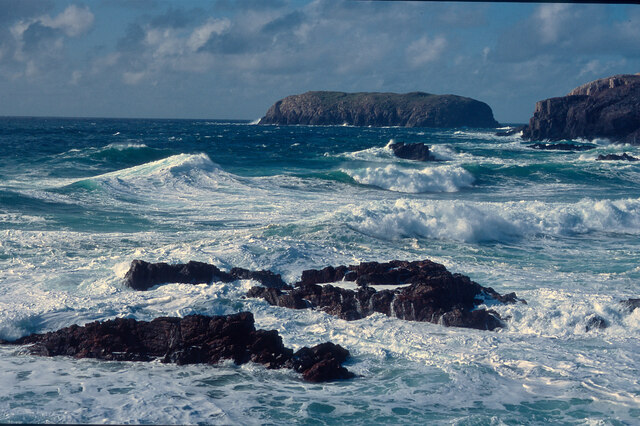
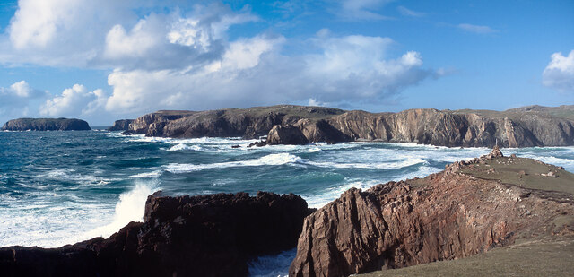
Carnan Mòr boasts spectacular views of the North Atlantic Ocean, with its sheer cliffs dropping dramatically into the water below. The headland is characterized by its rocky terrain, which is covered in a variety of vegetation, including grasses, mosses, and heather. This diverse flora provides a habitat for a range of wildlife, such as seabirds, small mammals, and various plant species.

The headland is a popular spot for nature enthusiasts and photographers, who are drawn to its rugged beauty and the opportunity to capture stunning coastal scenery. The area is also frequented by hikers and walkers, as there are several trails that wind their way along the headland, offering breathtaking views of the surrounding landscape.

Carnan Mòr's location on the coast makes it susceptible to the forces of erosion and weathering. The constant battering of the waves and wind against the cliffs has shaped the headland over time, creating unique geological formations and features.

Overall, Carnan Mòr is a captivating coastal feature that showcases the raw beauty of Scotland's coastline. Its rugged cliffs, diverse vegetation, and breathtaking views make it a must-visit destination for nature lovers and adventurers alike.

If you have any feedback on the listing, please let us know in the comments section below.

Carnan Mòr Images

Images are sourced within 2km of 58.152302/-7.0982037 or Grid Reference NB0029. Thanks to Geograph Open Source API. All images are credited.

Rocks on Druim Raois Outcropping rock and boulders litter the moorland below Mealaisbhal.
Rocks on Druim Raois
Outcropping rock and boulders litter the moorland below Mealaisbhal.
Road, Peat Cuttings and Moorland
Small pond beside the road to Islibhig This probably represents the site of a small quarry cut for stone when the road was being constructed.
Small pond beside the road to Islibhig
This probably represents the site of a small quarry cut for stone when the road was being constructed.
Geodh' an Fhithich Sea Stacks
Not Much of a View In clear weather there would be a view across the square towards Mealaisbhal. It might even be worth walking another couple of hundred metres to get Loch Sanndabhat in view. As it is, cloud base is not much higher than 150 metres above sea level, and all that is visible is a swathe of wet bog interspersed with glaciated outcrops of Lewisian gneiss.
Not Much of a View
In clear weather there would be a view across the square towards Mealaisbhal. It might even be worth walking another couple of hundred metres to get Loch Sanndabhat in view. As it is, cloud base is not much higher than 150 metres above sea level, and all that is visible is a swathe of wet bog interspersed with glaciated outcrops of Lewisian gneiss.
A pretty lochan This is Lochan Mealabhat, two thirds of which is in this square. It is a pleasing geograph photo, because it clearly shows what you can see on the map: I'm standing on a little tongue of land that sticks out into the lochan, the tongue is in the square, and I'm looking across to a similar tongue.
A pretty lochan
This is Lochan Mealabhat, two thirds of which is in this square. It is a pleasing geograph photo, because it clearly shows what you can see on the map: I'm standing on a little tongue of land that sticks out into the lochan, the tongue is in the square, and I'm looking across to a similar tongue.
Rubh' an Taroin headland
Rubh' an Taroin
Rubh' an Taroin
Coastal moor at Mullach an Tàroin
North end of Traigh Mhangarstaidh A beautiful beach with a fine Atlantic swell pounding in.
North end of Traigh Mhangarstaidh
A beautiful beach with a fine Atlantic swell pounding in.
Atlantic swell, Traigh Mhangarstaidh An exciting time being beside to a tumultuous sea - and at close range.
Atlantic swell, Traigh Mhangarstaidh
An exciting time being beside to a tumultuous sea - and at close range.
Looking down on Traigh Mhangarstaidh A walk for the view with my son on the beach.
Looking down on Traigh Mhangarstaidh
A walk for the view with my son on the beach.
Sea off Traigh Mhangarstaidh Exhilarating!
Sea off Traigh Mhangarstaidh
Exhilarating!
Coast line near Traigh Mhangarstaidh A wide view from stitching images.  An amazing experience.
Coast line near Traigh Mhangarstaidh
A wide view from stitching images. An amazing experience.
Aird Feinis A deep rock pool in a cleft on the top of Aird Feinis.
Aird Feinis
A deep rock pool in a cleft on the top of Aird Feinis.
Cairn on Aird Feinis A cairn marks the highest point on the relatively level summit of Aird Feinis, with Aird Mangarstadh in the background.
Cairn on Aird Feinis
A cairn marks the highest point on the relatively level summit of Aird Feinis, with Aird Mangarstadh in the background.
Boulder-strewn Hillside These strange rounded boulders lie on the hill slope above the road opposite Aird Feinis. They have been rounded and polished by the movement of ice during the last Ice Age, which ended about 10,000 years ago.
Boulder-strewn Hillside
These strange rounded boulders lie on the hill slope above the road opposite Aird Feinis. They have been rounded and polished by the movement of ice during the last Ice Age, which ended about 10,000 years ago.
Geodha an Fhithich Several ridges of rock have been eroded to form a series of jagged rock stacks north of Aird Feinis.
Geodha an Fhithich
Several ridges of rock have been eroded to form a series of jagged rock stacks north of Aird Feinis.
Show me another place!

Carnan Mòr is located at Grid Ref: NB0029 (Lat: 58.152302, Lng: -7.0982037)

Unitary Authority: Na h-Eileanan an Iar

Police Authority: Highlands and Islands

What 3 Words

///cello.grafted.tangling. Near Carloway, Na h-Eileanan Siar

Related Wikis

Stac Dhòmhnaill Chaim

Stac Dhòmnuill Chaim, or Stac Dhòmhnaill Chaim, or Stac Domhnuill Chaim, is a fortified promontory located near Mangursta (or Mangersta, Scottish Gaelic...

Brenish

Brenish (Scottish Gaelic: Brèinis) is a small village situated on the west coast of the Isle of Lewis, which is part of the Outer Hebrides of Scotland...

Gasker

Gasker is a small uninhabited islet in the Outer Hebrides of Scotland, 8 kilometres (4+1⁄2 nautical miles) southwest of Scarp, off the west coast of Harris...

Abhainn Dearg distillery

Abhainn Dearg distillery ( AV-in JAIRG) or Red River distillery is a Scotch whisky distillery in Uig, on the west coast of the Isle of Lewis in the Outer...

Nearby Amenities

Located within 500m of 58.152302,-7.0982037
Passing Place
Lat/Long: 58.1490941/-7.1030014
Passing Place
Lat/Long: 58.1554428/-7.0935727
Passing Place
Lat/Long: 58.1497268/-7.101696
Passing Place
Lat/Long: 58.1521462/-7.0995334
Passing Place
Lat/Long: 58.1529123/-7.0975107
Barrier: cattle_grid
Lat/Long: 58.1516336/-7.1000395
Passing Place
Lat/Long: 58.1546661/-7.0950181
Power: pole
Lat/Long: 58.1556371/-7.0939168
Power: pole
Lat/Long: 58.1551333/-7.0949277
Power: pole
Lat/Long: 58.1544156/-7.0953511
Power: pole
Lat/Long: 58.1538499/-7.0956978
Power: pole
Lat/Long: 58.1535433/-7.0959966
Power: pole
Lat/Long: 58.152904/-7.0966388
Power: pole
Lat/Long: 58.1523891/-7.097083
Power: pole
Lat/Long: 58.151786/-7.0976457
Power: pole
Lat/Long: 58.1511915/-7.0982052
Power: pole
Lat/Long: 58.1505656/-7.0989461
Power: pole
Lat/Long: 58.1499177/-7.0996871
Power: pole
Lat/Long: 58.1492512/-7.1004391
Power: pole
Lat/Long: 58.1486791/-7.1011195
Passing Place
Lat/Long: 58.1503156/-7.100744
Passing Place
Lat/Long: 58.1540163/-7.0965263
The data included in this document is from www.openstreetmap.org. The data is made available under ODbL.

Have you been to Carnan Mòr?

Leave your review of Carnan Mòr below (or comments, questions and feedback).